


Summary
Limes Transalutanus[1] is the modern name given to a fortified frontier system of the Roman Empire, built on the western edge of Teleorman's forests as part of the Dacian Limes in the Roman province of Dacia, modern-day Romania.[2][3]

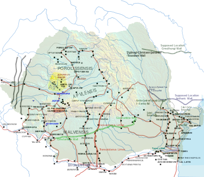
The Limes Transalutanus, of 235 km length,[4] was needed to shorten the line of communication to the strategic fort at Angustia by almost 30 per cent compared to the earlier route via the Limes Alutanus.[5][6]
The Limes dates from the first half of the 3rd century AD[7] although the road and many of the forts on the Limes date from the end of Trajan's Dacian Wars (c.106 AD) and were in use until the reign of Philip the Arab.[8] Between 244–247, under Philip the Arab, after the Carpian and Getae (or Goths) attacks, the Roman Imperial army abandoned the limes for some time. They returned to the limes, but closed the road to the Rucăr-Bran pass starting from the modern village of Băiculeşti.
The frontier system was composed of a road linking military forts and towers and in the southern, less mountainous, part a 3 m high vallum 10–12 m wide reinforced with wooden palisades on stone walls and also a ditch. In this southern part the limes was parallel to Olt river at a distance varying from 5 to 30 km east of the river.
Later, another limes was built in the area, known as Brazda lui Novac.
Forts edit
Known forts on the Limes Transalutanus include (from the north):
- Cumidava (castra)
- Castra of Drumul Carului
- Jidava (castra) also called Campulung Muscel
- Castra of Albota
- Săpata
- Castra of Fâlfani
- Gresia Roman fort
- Castra of Băneasa
See also edit
References edit
- ^ Technological challenges on the Limes Transalutanus, Eugen S. Teodor, Dan Ştefan, https://www.antiquity.ac.uk/projgall/teodor342
- ^ Limes https://limesromania.ro/en/articole/about-the-project/
- ^ Eugen Teodor, The Invisible Giant: Limes Transalutanus. An overview south of Argeş River ISBN 978-606-537-298-6 ©Editura Cetatea de Scaun, Târgoviște, 2015
- ^ Măndescu, Dragoş. “Then and Now. The Limes Transalutanus 130 Years after Its Discovery.” BEITRÄGE ZUM WELTERBE LIMES Bayerisches Landesamt für Denkmalpflege · Deutsche Limeskommission Limes XXIII Proceedings of the 23rd International Congress of Roman Frontier Studies Ingolstadt 2015, C. Sebastian Sommer, Suzana Matešic (Hrsg.) · In Kommission: Nünnerich-Asmus Verlag · Mainz (2018)
- ^ Teodor, Eugen & Ștefan, Maria-Magdalena. (2014). LANDSCAPE ARCHAEOLOGY ALONG LIMES TRANSALUTANUS. JOURNAL OF ANCIENT HISTORY AND ARCHAEOLOGY. 1. 10.14795/j.v1i3.68
- ^ TEODOR, E.S. 2013. Uriaşul invizibil: Limes Transalutanus. O reevaluare la sud de râul Argeş. Târgovişte: Editura Cetatea de Scaun
- ^ E. S. Teodor et al. Roman frontier crossing Mocanului Valley, Cercetări Arheologice 29.2, 2022, 543-556
- ^ C. C. Petolescu, Auxilia dacica. Contribuție la istoria militară a Daciei Roma- ne (Bucharest 2002) p55
External links edit
- Dorin Bondoc (Repertoriul fortificaţiilor de pe ripa nordică a limesului Dunării de Jos în epoca romană)