


Summary
Lindenwold is a borough in Camden County, in the U.S. state of New Jersey. As of the 2020 United States census, the borough's population was 21,641,[10][11] an increase of 4,028 (+22.9%) from the 2010 census count of 17,613,[20][21] which in turn reflected an increase of 199 (+1.1%) from the 17,414 counted in the 2000 census.[22]
Lindenwold, New Jersey | |
|---|---|
 Train pulls into Lindenwold station, March 2008 | |
 Seal | |
 Lindenwold highlighted in Camden County. Inset: Location of Camden County in the State of New Jersey. | |
 Census Bureau map of Lindenwold, New Jersey | |
 Lindenwold Location in Camden County  Lindenwold Location in New Jersey  Lindenwold Location in the United States | |
| Coordinates: 39°49′08″N 74°59′24″W / 39.818832°N 74.989966°W[1][2] | |
| Country | |
| State | |
| County | Camden |
| Incorporated | April 23, 1929 |
| Government | |
| • Type | Borough |
| • Body | Borough Council |
| • Mayor | Richard E. Roach Jr. (D term ends December 31, 2023)[3][4] |
| • Administrator | Dawn S. Thompson[5] |
| • Municipal clerk | Deborah Jackson[6] |
| Area | |
| • Total | 3.94 sq mi (10.21 km2) |
| • Land | 3.90 sq mi (10.11 km2) |
| • Water | 0.04 sq mi (0.11 km2) 1.07% |
| • Rank | 300th of 565 in state 9th of 37 in county[1] |
| Elevation | 56 ft (17 m) |
| Population | |
| • Total | 21,641 |
| • Estimate | 21,595 |
| • Rank | 129th of 565 in state 7th of 37 in county[13] |
| • Density | 5,546.1/sq mi (2,141.4/km2) |
| • Rank | 99th of 565 in state 9th of 37 in county[13] |
| Time zone | UTC−05:00 (Eastern (EST)) |
| • Summer (DST) | UTC−04:00 (Eastern (EDT)) |
| ZIP Code | |
| Area code | 856[16] |
| FIPS code | 3400740440[1][17][18] |
| GNIS feature ID | 0885279[1][19] |
| Website | www |
As of 2020, Lindenwold had the 10th-highest property tax rate in New Jersey with an equalized rate of 4.810% compared to 3.470% in the county as a whole and a statewide average of 2.279%.[23] The borough is part of the South Jersey region of the state.
History edit
Lindenwold was created on April 23, 1929, from Clementon Township, one of seven municipalities created from the now-defunct township, and one of five new municipalities created on that same date: Hi-Nella, Pine Hill, Pine Valley (since merged with Pine Hill), and Somerdale.[24] The borough's first official meeting was held on the following May 31 in the old Fire Hall at Linden Avenue and Berlin Road. The name "Lindenwold" (German for "linden forest") was suggested by Wimer Bedford, a local resident who had been reading a German book that included the word. Bedford sought to have linden trees planted along the borough's streets, but local officials chose cheaper trees as an alternative.[25][26]
Geography edit
According to the U.S. Census Bureau, the borough had a total area of 3.94 square miles (10.21 km2), including 3.90 square miles (10.11 km2) of land and 0.04 square miles (0.11 km2) of water (1.07%).[1][2] Unincorporated communities, localities and place names located partially or completely within the township include Kirkwood and Lucastown.[27]
Lindenwold borders the Camden County municipalities of Berlin Borough, Berlin Township, Clementon Borough, Gibbsboro, Gloucester Township, Laurel Springs, Pine Hill, Somerdale, Stratford, and Voorhees Township.[28][29][30]
Demographics edit
| Census | Pop. | Note | %± |
|---|---|---|---|
| 1930 | 2,523 | — | |
| 1940 | 2,552 | 1.1% | |
| 1950 | 3,479 | 36.3% | |
| 1960 | 7,335 | 110.8% | |
| 1970 | 12,199 | 66.3% | |
| 1980 | 18,196 | 49.2% | |
| 1990 | 18,734 | 3.0% | |
| 2000 | 17,414 | −7.0% | |
| 2010 | 17,613 | 1.1% | |
| 2020 | 21,641 | 22.9% | |
| 2022 (est.) | 21,595 | [10][12] | −0.2% |
| Population sources: 1930–2000[31] 1930[32] 1940–2000[33] 2000[34][35] 2010[20][21] 2020[10][11] | |||
2010 census edit
The 2010 United States census counted 17,613 people, 7,426 households, and 4,211 families in the borough. The population density was 4,525.1 per square mile (1,747.2/km2). There were 8,251 housing units at an average density of 2,119.8 per square mile (818.5/km2). The racial makeup was 48.08% (8,469) White, 34.66% (6,104) Black or African American, 0.44% (78) Native American, 2.80% (493) Asian, 0.02% (4) Pacific Islander, 10.34% (1,822) from other races, and 3.65% (643) from two or more races. Hispanic or Latino of any race were 20.85% (3,673) of the population.[20]
Of the 7,426 households, 26.5% had children under the age of 18; 30.9% were married couples living together; 18.8% had a female householder with no husband present and 43.3% were non-families. Of all households, 33.8% were made up of individuals and 8.2% had someone living alone who was 65 years of age or older. The average household size was 2.37 and the average family size was 3.04.[20]
22.5% of the population were under the age of 18, 11.2% from 18 to 24, 32.5% from 25 to 44, 24.4% from 45 to 64, and 9.4% who were 65 years of age or older. The median age was 33.3 years. For every 100 females, the population had 90.6 males. For every 100 females ages 18 and older there were 87.9 males.[20]
The Census Bureau's 2006–2010 American Community Survey showed that (in 2010 inflation-adjusted dollars) median household income was $47,462 (with a margin of error of +/− $2,694) and the median family income was $55,906 (+/− $3,257). Males had a median income of $34,580 (+/− $5,293) versus $35,523 (+/− $3,099) for females. The per capita income for the borough was $22,793 (+/− $1,111). About 9.8% of families and 11.1% of the population were below the poverty line, including 15.0% of those under age 18 and 4.4% of those age 65 or over.[36]
2000 census edit
As of the 2000 census,[17] there were 17,414 people, 7,465 households, and 4,299 families residing in the borough. The population density was 4,415.5 inhabitants per square mile (1,704.8/km2). There were 8,244 housing units at an average density of 2,090.3 per square mile (807.1/km2). The racial makeup of the borough was 61.42% White, 28.22% African American, 0.48% Native American, 3.53% Asian, 0.06% Pacific Islander, 3.24% from other races, and 3.06% from two or more races. Hispanic or Latino of any race were 7.56% of the population.[34][35]
There were 7,465 households, out of which 29.1% had children under the age of 18 living with them, 35.0% were married couples living together, 16.6% had a female householder with no husband present, and 42.4% were non-families. 34.3% of all households were made up of individuals, and 7.0% had someone living alone who was 65 years of age or older. The average household size was 2.32 and the average family size was 3.00.[34][35]
In the borough, the population was spread out, with 23.6% under the age of 18, 10.4% from 18 to 24, 36.2% from 25 to 44, 20.9% from 45 to 64, and 8.8% who were 65 years of age or older. The median age was 33 years. For every 100 females, there were 91.3 males. For every 100 females age 18 and over, there were 87.8 males.[34][35]
The median income for a household in the borough was $36,080, and the median income for a family was $40,931. Males had a median income of $34,990 versus $26,514 for females. The per capita income for the borough was $18,659. About 11.3% of families and 11.8% of the population were below the poverty line, including 15.1% of those under age 18 and 5.1% of those age 65 or over.[34][35]
Government edit
Local government edit
Lindenwold is governed under the borough form of New Jersey municipal government, which is used in 218 municipalities (of the 564) statewide, making it the most common form of government in New Jersey.[37] The governing body is comprised of the mayor and the borough council, with all positions elected at-large on a partisan basis as part of the November general election. A mayor is elected directly by the voters to a four-year term of office. The borough council has six members elected to serve three-year terms on a staggered basis, with two seats coming up for election each year in a three-year cycle.[7] The borough form of government used by Lindenwold is a "weak mayor / strong council" government in which council members act as the legislative body with the mayor presiding at meetings and voting only in the event of a tie. The mayor can veto ordinances subject to an override by a two-thirds majority vote of the council. The mayor makes committee and liaison assignments for council members, and most appointments are made by the mayor with the advice and consent of the council.[38][39]
In the November 2021 general election, Walter F. Lenkowski was elected to fill the seat expiring in December 2022 that had been held by Joseph C. Strippoli until he resigned from office in July 2021.[40][41]
As of 2023[update], the mayor of Lindenwold Borough is Democrat Richard E. Roach Jr., whose term of office ends December 31, 2023. Members of the Lindenwold Borough Council are Linda M. Hess (D, 2023), Walter F. Lenkowski (D, 2025), Raymond D. Morrisey (D, 2025), Odessa Patton (2024), Cheryle Randolph-Sharpe (D, 2024), Sandra Sinon (D, 2023).[3][42][43][41][44]
The borough of Lindenwold is serviced by Ambulnz (formally Jefferson Health) EMS 24/7. EMS is staffed with two NJ State Certified EMTs who operate as BLS 63 daily. EMS also covers the neighboring borough Clementon.
Federal, state, and county representation edit
Lindenwold is located in the 1st Congressional District[45] and is part of New Jersey's 6th state legislative district.[46]
For the 118th United States Congress, New Jersey's 1st congressional district is represented by Donald Norcross (D, Camden).[47][48] New Jersey is represented in the United States Senate by Democrats Cory Booker (Newark, term ends 2027)[49] and Bob Menendez (Englewood Cliffs, term ends 2025).[50][51]
For the 2024-2025 session, the 6th legislative district of the New Jersey Legislature is represented in the State Senate by James Beach (D, Voorhees Township) and in the General Assembly by Louis Greenwald (D, Voorhees Township) and Pamela Rosen Lampitt (D, Cherry Hill).[52]
Camden County is governed by a Board of County Commissioners comprised of seven members chosen at-large in partisan elections for three-year terms on a staggered basis by the residents of the county, with either two or three seats up for election each year as part of the November general election. At a reorganization meeting held in January after each election, the newly constituted Board of Commissioners selects one member to serve as Director and another as Deputy Director, each serving a one-year term in that role.[53] As of 2024[update], Camden County's Commissioners are: Commissioner Director Louis Cappelli Jr. (D, Collingswood, 2026),[54] Commissioner Deputy Director Edward T. McDonnell (D, Pennsauken Township, 2025),[55] Virginia Ruiz Betteridge (D, Runnemede, 2025),[56] Almar Dyer (D, Pennsauken Township, 2024),[57] Melinda Kane (D, Cherry Hill, 2024),[58] Jeffrey L. Nash (D, Winslow Township, 2024),[59] and Jonathan L. Young Sr. (D, Berlin Township, 2026).[60][53][61][62][63]
Camden County's constitutional officers are: Clerk Joseph Ripa (D, Voorhees Township, 2024),[64][65] Sheriff Gilbert "Whip" Wilson (D, Camden, 2024)[66][67] and Surrogate Michelle Gentek-Mayer (D, Gloucester Township, 2025).[68][69][70]
Politics edit
As of March 2011, there were a total of 9,970 registered voters in Lindenwood, of which 4,510 (45.2%) were registered as Democrats, 714 (7.2%) were registered as Republicans and 4,742 (47.6%) were registered as Unaffiliated. There were 4 voters registered as Libertarians or Greens.[71]
In the 2012 presidential election, Democrat Barack Obama received 80.2% of the vote (4,936 cast), ahead of Republican Mitt Romney with 18.7% (1,152 votes), and other candidates with 1.1% (67 votes), among the 6,206 ballots cast by the borough's 10,991 registered voters (51 ballots were spoiled), for a turnout of 56.5%.[72][73] In the 2008 presidential election, Democrat Barack Obama received 76.4% of the vote (5,208 cast), ahead of Republican John McCain, who received around 20.5% (1,400 votes), with 6,813 ballots cast among the borough's 9,556 registered voters, for a turnout of 71.3%.[74] In the 2004 presidential election, Democrat John Kerry received 71.1% of the vote (4,295 ballots cast), outpolling Republican George W. Bush, who received around 27.3% (1,650 votes), with 6,042 ballots cast among the borough's 9,306 registered voters, for a turnout percentage of 64.9.[75]
In the 2013 gubernatorial election, Democrat Barbara Buono received 52.6% of the vote (1,406 cast), ahead of Republican Chris Christie with 45.7% (1,221 votes), and other candidates with 1.7% (46 votes), among the 2,744 ballots cast by the borough's 11,121 registered voters (71 ballots were spoiled), for a turnout of 24.7%.[76][77] In the 2009 gubernatorial election, Democrat Jon Corzine received 61.8% of the vote (1,871 ballots cast), ahead of both Republican Chris Christie with 30.6% (927 votes) and Independent Chris Daggett with 4.5% (135 votes), with 3,027 ballots cast among the borough's 9,848 registered voters, yielding a 30.7% turnout.[78]
Education edit
The Lindenwold Public Schools serve students in pre-kindergarten through twelfth grade.[79] As of the 2018–19 school year, the district, comprised of five schools, had an enrollment of 2,845 students and 240.1 classroom teachers (on an FTE basis), for a student–teacher ratio of 11.8:1.[80] Schools in the district (with 2018–19 enrollment data from the National Center for Education Statistics[81]) are Lindenwold Preschool[82] with 159 students in Pre-K, Lindenwold School 4[83] with 630 students in grades K–4, Lindenwold School 5[84] with 591 students in grades K–4, Lindenwold Middle School[85] with 840 students in grades 5–8, and Lindenwold High School[86] with 543 students in grades 9–12.[87]
At the end of the 2007–08 school year, the Roman Catholic Diocese of Camden closed Saint Lawrence Regional School and merged it together with schools in Somerdale and Stratford to create John Paul II Regional School.[88]
Transportation edit
Roads and highways edit
As of May 2010[update], the borough had a total of 44.90 miles (72.26 km) of roadways, of which 31.41 miles (50.55 km) were maintained by the municipality, 12.14 miles (19.54 km) by Camden County and 1.35 miles (2.17 km) by the New Jersey Department of Transportation.[89]
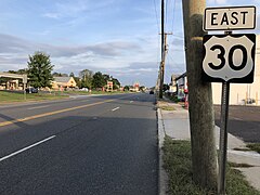
U.S. Route 30 is the main highway serving Lindenwold.[90]
Public transportation edit
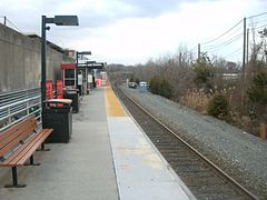
The Lindenwold station[91] is home to the eastern terminus and main operations facility for the PATCO Speedline.[92] It is also a stop on NJ Transit's Atlantic City Line, which runs from 30th Street Station in Philadelphia to the Atlantic City Rail Terminal.[93]
NJ Transit offers bus service between the borough and Camden on the 403 route, with local service on the 451 and 459 routes, and service to Atlantic City on the 554.[94][95]
Notable people edit
People who were born in, residents of, or otherwise closely associated with Lindenwold include:
- Earl Harrison (born 1961), former professional basketball player[96]
- Suzy Hotrod (born 1980), roller derby skater[97]
- Carlton R. Rouh (1919–1977), Medal of Honor recipient[98]
- Jimmy Woode (1926–2005), jazz bassist[99]
References edit
- ^ a b c d e 2019 Census Gazetteer Files: New Jersey Places, United States Census Bureau. Accessed July 1, 2020.
- ^ a b US Gazetteer files: 2010, 2000, and 1990, United States Census Bureau. Accessed September 4, 2014.
- ^ a b Meet Your Mayor and Council, Lindenwold Borough. Accessed June 8, 2023.
- ^ 2023 New Jersey Mayors Directory, New Jersey Department of Community Affairs, updated February 8, 2023. Accessed February 10, 2023.
- ^ Borough Administrator, Lindenwold Borough. Accessed June 8, 2023.
- ^ Borough Clerk / Registrar, Lindenwold Borough. Accessed June 8, 2023.
- ^ a b 2012 New Jersey Legislative District Data Book, Rutgers University Edward J. Bloustein School of Planning and Public Policy, March 2013, p. 24.
- ^ "ArcGIS REST Services Directory". United States Census Bureau. Retrieved October 11, 2022.
- ^ U.S. Geological Survey Geographic Names Information System: Borough of Lindenwold, Geographic Names Information System. Accessed March 7, 2013.
- ^ a b c d e QuickFacts Lindenwold borough, New Jersey, United States Census Bureau. Accessed December 22, 2022.
- ^ a b c Total Population: Census 2010 - Census 2020 New Jersey Municipalities, New Jersey Department of Labor and Workforce Development. Accessed December 1, 2022.
- ^ a b Annual Estimates of the Resident Population for Minor Civil Divisions in New Jersey: April 1, 2020 to July 1, 2022, United States Census Bureau, released May 2023. Accessed May 18, 2023.
- ^ a b Population Density by County and Municipality: New Jersey, 2020 and 2021, New Jersey Department of Labor and Workforce Development. Accessed March 1, 2023.
- ^ Look Up a ZIP Code for Lindenwold, NJ, United States Postal Service. Accessed August 28, 2013.
- ^ Zip Codes, State of New Jersey. Accessed August 28, 2013.
- ^ Area Code Lookup - NPA NXX for Lindenwold, NJ, Area-Codes.com. Accessed August 28, 2013.
- ^ a b U.S. Census website, United States Census Bureau. Accessed September 4, 2014.
- ^ Geographic Codes Lookup for New Jersey, Missouri Census Data Center. Accessed April 1, 2022.
- ^ US Board on Geographic Names, United States Geological Survey. Accessed September 4, 2014.
- ^ a b c d e DP-1 - Profile of General Population and Housing Characteristics: 2010 for Lindenwold borough, Camden County, New Jersey Archived 2020-02-12 at archive.today, United States Census Bureau. Accessed June 21, 2012.
- ^ a b Profile of General Demographic Characteristics: 2010 for Lindenwold borough[permanent dead link], New Jersey Department of Labor and Workforce Development. Accessed June 21, 2012.
- ^ Table 7. Population for the Counties and Municipalities in New Jersey: 1990, 2000 and 2010, New Jersey Department of Labor and Workforce Development, February 2011. Accessed May 1, 2023.
- ^ "Here are the 30 N.J. towns with the highest property tax rates", NJ Advance Media for NJ.com, March 15, 2021. Accessed January 19, 2022. "The average equalized tax rate in New Jersey was 2.279 in 2020, according to data from the Department of Community Affairs. Here is the list of 30 New Jersey towns with the highest property tax rates.... 10. Lindenwold Equalized tax rate in Lindenwold Borough, Camden County, was 4.810 in 2020 Average equalized tax rate in Camden County: 3.470"
- ^ Snyder, John P. The Story of New Jersey's Civil Boundaries: 1606-1968, Bureau of Geology and Topography; Trenton, New Jersey; 1969. p. 107. Accessed June 21, 2012.
- ^ Lindenwold Borough Community Pages, Lindenwold Official Government Website. Accessed June 21, 2012.
- ^ Laughlin, Jason. "Lindenwold: A tree by any name" [dead link], Courier-Post, October 18, 2006. Accessed September 3, 2015. "Wimer Bedford gave the town its name when it became a town in 1885. In German, Lindenwold means Linden Woods. He had hoped to plant linden trees throughout the community, but while he was away on business the town government found cheaper and more affordable trees and planted them instead."
- ^ Locality Search, State of New Jersey. Accessed May 21, 2015.
- ^ Areas touching Lindenwold, MapIt. Accessed September 18, 2019.
- ^ Municipalities within Camden County, NJ, Delaware Valley Regional Planning Commission. Accessed February 25, 2020.
- ^ New Jersey Municipal Boundaries, New Jersey Department of Transportation. Accessed November 15, 2019.
- ^ Barnett, Bob. Population Data for Camden County Municipalities, 1850 - 2000, WestJersey.org, January 6, 2011. Accessed October 7, 2012.
- ^ Fifteenth Census of the United States: 1930 - Population Volume I, United States Census Bureau, p. 715. Accessed October 7, 2012.
- ^ Table 6: New Jersey Resident Population by Municipality: 1940 - 2000, Workforce New Jersey Public Information Network, August 2001. Accessed May 1, 2023.
- ^ a b c d e Census 2000 Profiles of Demographic / Social / Economic / Housing Characteristics for Lindenwold borough, New Jersey Archived 2007-07-11 at the Wayback Machine, United States Census Bureau. Accessed October 7, 2012.
- ^ a b c d e DP-1: Profile of General Demographic Characteristics: 2000 - Census 2000 Summary File 1 (SF 1) 100-Percent Data for Lindenwold borough, Camden County, New Jersey Archived 2020-02-12 at archive.today, United States Census Bureau. Accessed October 7, 2012.
- ^ DP03: Selected Economic Characteristics from the 2006-2010 American Community Survey 5-Year Estimates for Lindenwold borough, Camden County, New Jersey Archived 2020-02-12 at archive.today, United States Census Bureau. Accessed June 20, 2012.
- ^ Inventory of Municipal Forms of Government in New Jersey, Rutgers University Center for Government Studies, July 1, 2011. Accessed June 1, 2023.
- ^ Cerra, Michael F. "Forms of Government: Everything You've Always Wanted to Know, But Were Afraid to Ask" Archived 2014-09-24 at the Wayback Machine, New Jersey State League of Municipalities. Accessed November 30, 2014.
- ^ "Forms of Municipal Government in New Jersey", p. 6. Rutgers University Center for Government Studies. Accessed June 1, 2023.
- ^ Mayor and Council Meeting Minutes for July 28, 2021, Borough of Lindenwold. Accessed July 11, 2022. "Mayor Roach updated that the numbers are rising for cases in Lindenwold. Mayor announced that he has received a letter of resignation for Councilman Strippoli. He thanked the former Mayor and Councilman for all his years of service to the Borough of Lindenwold."
- ^ a b 2021 General Election November 2, 2021 Official Election Results, Camden County, New Jersey, update November 15, 2021. Accessed January 1, 2022.
- ^ 2023 Municipal Data Sheet, Lindenwold Borough. Accessed June 8, 2023.
- ^ Official Election Results 2022 General Election November 8, 2022, Camden County, New Jersey, as of November 21, 2022. Accessed January 1, 2023.
- ^ 2020 General Election November 3, 2020 Official Election Results, Camden County, New Jersey, update November 20, 2020. Accessed January 1, 2021.
- ^ Plan Components Report, New Jersey Redistricting Commission, December 23, 2011. Accessed February 1, 2020.
- ^ Districts by Number for 2023-2031, New Jersey Legislature. Accessed September 18, 2023.
- ^ Directory of Representatives: New Jersey, United States House of Representatives. Accessed January 3, 2019.
- ^ Full Biography, Congressman Donald Norcross. Accessed January 3, 2019. "Donald and his wife Andrea live in Camden City and are the proud parents of three grown children and grandparents of two."
- ^ U.S. Sen. Cory Booker cruises past Republican challenger Rik Mehta in New Jersey, PhillyVoice. Accessed April 30, 2021. "He now owns a home and lives in Newark's Central Ward community."
- ^ Biography of Bob Menendez, United States Senate, January 26, 2015. "Menendez, who started his political career in Union City, moved in September from Paramus to one of Harrison's new apartment buildings near the town's PATH station.."
- ^ Home, sweet home: Bob Menendez back in Hudson County. nj.com. Accessed April 30, 2021. "Booker, Cory A. - (D - NJ) Class II; Menendez, Robert - (D - NJ) Class I"
- ^ Legislative Roster for District 6, New Jersey Legislature. Accessed January 12, 2024.
- ^ a b About the Board of Commissioners, Camden County, New Jersey. Accessed February 1, 2023.
- ^ Louis Cappelli, Jr., Camden County, New Jersey. Accessed February 1, 2023.
- ^ Edward T. McDonnell, Camden County, New Jersey. Accessed February 1, 2023.
- ^ Virginia Betteridge, Camden County, New Jersey. Accessed February 1, 2023.
- ^ Al Dyer, Camden County, New Jersey. Accessed February 1, 2023. As of date accessed, incorrect term dates are listed.
- ^ Melinda Kane, Camden County, New Jersey. Accessed February 1, 2023. As of date accessed, incorrect term dates are listed.
- ^ Jeffrey L. Nash, Camden County, New Jersey. Accessed February 1, 2023.
- ^ Jonathan L. Young Sr., Camden County, New Jersey. Accessed February 1, 2023.
- ^ Official Election Results 2022 General Election November 8, 2022, Camden County, New Jersey, as of November 21, 2022. Accessed January 1, 2023.
- ^ Official Election Results 2021 General Election November 2, 2021, Camden County, New Jersey, updated November 15, 2021. Accessed January 1, 2022.
- ^ Official Election Results 2020 General Election November 3, 2020, Camden County, New Jersey, updated November 20, 2020. Accessed January 1, 2021.
- ^ County Clerk Joseph Ripa, Camden County, New Jersey. Accessed February 1, 2023.
- ^ Members List: Clerks, Constitutional Officers Association of New Jersey. Accessed February 1, 2023.
- ^ Sheriff Gilbert "Whip" Wilson, Camden County, New Jersey. Accessed February 1, 2023. As of date accessed, incorrect term dates are listed.
- ^ Members List: Sheriffs, Constitutional Officers Association of New Jersey. Accessed February 1, 2023.
- ^ Surrogate Michelle Gentek-Mayer, Camden County, New Jersey. Accessed February 1, 2023.
- ^ Members List: Surrogates, Constitutional Officers Association of New Jersey. Accessed February 1, 2023.
- ^ Your Government, Camden County, New Jersey. Accessed February 1, 2023.
- ^ Voter Registration Summary - Camden, New Jersey Department of State Division of Elections, March 23, 2011. Accessed October 15, 2012.
- ^ "Presidential General Election Results - November 6, 2012 - Camden County" (PDF). New Jersey Department of Elections. March 15, 2013. Retrieved December 24, 2014.
- ^ "Number of Registered Voters and Ballots Cast - November 6, 2012 - General Election Results - Camden County" (PDF). New Jersey Department of Elections. March 15, 2013. Retrieved December 24, 2014.
- ^ 2008 Presidential General Election Results: Camden County, New Jersey Department of State Division of Elections, December 23, 2008. Accessed October 15, 2012.
- ^ 2004 Presidential Election: Camden County, New Jersey Department of State Division of Elections, December 13, 2004. Accessed October 15, 2012.
- ^ "Governor - Camden County" (PDF). New Jersey Department of Elections. January 29, 2014. Retrieved December 24, 2014.
- ^ "Number of Registered Voters and Ballots Cast - November 5, 2013 - General Election Results - Camden County" (PDF). New Jersey Department of Elections. January 29, 2014. Retrieved December 24, 2014.
- ^ 2009 Governor: Camden County Archived 2012-10-17 at the Wayback Machine, New Jersey Department of State Division of Elections, December 31, 2009. Accessed October 15, 2012.
- ^ Lindenwold Board of Education Bylaw 0110 - Identification, Lindenwold Public Schools. Accessed June 4, 2020. "Purpose: The Board of Education exists for the purpose of providing a thorough and efficient system of free public education in grades Pre-Kindergarten through twelve in the Lindenwold School District. Composition: The Lindenwold School District is comprised of all the area within the municipal boundaries of Lindenwold"
- ^ District information for Lindenwold Public School District, National Center for Education Statistics. Accessed April 1, 2020.
- ^ School Data for the Lindenwold Public Schools, National Center for Education Statistics. Accessed April 1, 2020.
- ^ Lindenwold Preschool, Lindenwold Public Schools. Accessed June 4, 2020.
- ^ Lindenwold School 4, Lindenwold Public Schools. Accessed June 4, 2020.
- ^ Lindenwold School 5, Lindenwold Public Schools. Accessed June 4, 2020.
- ^ Lindenwold Middle School, Lindenwold Public Schools. Accessed June 4, 2020.
- ^ Lindenwold High School, Lindenwold Public Schools. Accessed June 4, 2020.
- ^ New Jersey School Directory for the Lindenwold Public Schools, New Jersey Department of Education. Accessed February 1, 2024.
- ^ Staff. "In the fall, different schools will open", Catholic Star Herald, June 19, 2008. Accessed October 19, 2013. "Our Lady of Grace/Holy Rosary, Somerdale, and St. Lawrence, Lindenwold, will merge in Stratford with St. Luke elementary school, and the three will become John Paul II Regional School."
- ^ Camden County Mileage by Municipality and Jurisdiction, New Jersey Department of Transportation, May 2010. Accessed July 18, 2014.
- ^ U.S. Route 30 Straight Line Diagram, New Jersey Department of Transportation, updated March 2018. Accessed December 22, 2022.
- ^ Lindenwold station, NJ Transit. Accessed October 19, 2013.
- ^ Lindenwold Station , PATCO Speedline. Accessed October 19, 2013.
- ^ Atlantic City Rail Line, NJ Transit. Accessed October 19, 2013.
- ^ Camden County Bus/Rail Connections, NJ Transit, backed up by the Internet Archive as of May 22, 2009. Accessed October 17, 2011.
- ^ South Jersey Transit Guide Archived 2018-09-29 at the Wayback Machine, Cross County Connection, as of April 1, 2010. Accessed December 13, 2014.
- ^ Staff. "Martin's investment pays off as Morehead claims title", The Advocate-Messenger, March 12, 1984. Accessed August 12, 2016. "Harrison, a 6-foot-7 senior from Lindenwold, N.J., grabbed a game-high 13 rebounds and hit nine of 11 free throws and three of seven from the field to lead the winners with 15 points."
- ^ "Suzy Hotrod" Archived 2012-02-25 at the Wayback Machine, ESPN. Accessed October 17, 2011.
- ^ DeCastro, Lavinia. "Lindenwold recalls a hometown hero", Courier-Post, September 14, 2009. Accessed October 17, 2011. "In Lindenwold, Carlton Rouh is a household name. Rouh was once Lindenwold's mayor, but he is remembered for more than his years in public service."
- ^ Keepnews, Peter. "Jimmy Woode, Ex-Ellington Bassist, Dies at 78", The New York Times, April 30, 2005. Accessed September 3, 2015. "Jimmy Woode, a bassist who spent five years with Duke Ellington but was best known as one of the leading figures on the European jazz scene, died on Saturday at his home in Lindenwold, N.J."
External links edit
- Lindenwold Borough municipal website
- Lindenwold Public Schools
- School Performance Reports for the Lindenwold Public Schools, New Jersey Department of Education
- School Data for the Lindenwold Public Schools, National Center for Education Statistics