


Summary
This is a list of Category A listed buildings in the Highland council area of northern Scotland.

In Scotland, the term listed building refers to a building or other structure officially designated as being of "special architectural or historic interest".[1] Category A structures are those considered to be "buildings of national or international importance, either architectural or historic, or fine little-altered examples of some particular period, style or building type."[2] Listing was begun by a provision in the Town and Country Planning (Scotland) Act 1947, and the current legislative basis for listing is the Planning (Listed Buildings and Conservation Areas) (Scotland) Act 1997.[3] The authority for listing rests with Historic Scotland, an executive agency of the Scottish Government, which inherited this role from the Scottish Development Department in 1991. Once listed, severe restrictions are imposed on the modifications allowed to a building's structure or its fittings. Listed building consent must be obtained from local authorities prior to any alteration to such a structure.[3] There are approximately 47,400 listed buildings in Scotland, of which around 8% (some 3,800) are Category A.[4]
The council area of Highland is the largest in Scotland, covering 30,659 square kilometres (11,838 sq mi), and it has a population of around 220,500. There are 185 Category A listed buildings in the area.
Listed buildings edit
| Name | Location | Date Listed | Grid Ref. [note 1] | Geo-coordinates | Notes | LB Number [note 2] | Image |
|---|---|---|---|---|---|---|---|
| Sluggan Bridge over River Dulnain | Sluggan, Carrbridge | NH8698922008 | 57°16′29″N 3°52′33″W / 57.274691°N 3.875884°W | [5] | 240 |  Upload another image | |
| Muckrach Castle | Dulnain Bridge | NH9858925051 | 57°18′17″N 3°41′05″W / 57.304737°N 3.684851°W | [6] | 249 |  Upload another image | |
| Croft House | Coylumbridge, Rothiemurchus | NH9029309343 | 57°09′42″N 3°48′56″W / 57.161785°N 3.815525°W | [7] | 251 |  Upload another image | |
| Aviemore railway station | Aviemore | NH8955312344 | 57°11′19″N 3°49′45″W / 57.188552°N 3.829084°W | [8] | 257 | 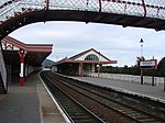 Upload another image | |
| Broomhill Bridge over River Spey | Broomhill, Nethy Bridge | NH9969122357 | 57°16′51″N 3°39′56″W / 57.280791°N 3.665476°W | [9] | 260 |  Upload another image | |
| Shin Railway Viaduct over Kyle of Sutherland | Kyle of Sutherland | NH5789395274 | 57°55′27″N 4°24′04″W / 57.924102°N 4.40098°W | [10] | 279 |  Upload another image | |
| Borrodale Viaduct over Borrodale Burn | Arisaig | NM6974685492 | 56°54′12″N 5°46′59″W / 56.90339°N 5.783152°W | [11] | 302 | 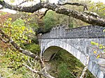 Upload another image | |
| Castle Tioram | Loch Moidart, Lochaber | NM6621172431 | 56°47′04″N 5°49′45″W / 56.784552°N 5.829072°W | [12] | 305 |  Upload another image | |
| St Finnan's Chapel and Burial Ground | Eilean Fhianain, Loch Shiel | NM7520468276 | 56°45′06″N 5°40′43″W / 56.75173°N 5.678545°W | [13] | 306 |  Upload another image | |
| Glenfinnan Monument | Glenfinnan | NM9061680575 | 56°52′09″N 5°26′13″W / 56.869195°N 5.437078°W | [14] | 308 |  Upload another image | |
| Glenfinnan Railway Viaduct over River Finnan | Glenfinnan | NM9098681349 | 56°52′35″N 5°25′54″W / 56.876303°N 5.431656°W | [15] | 310 |  Upload another image | |
| Kinlochmoidart House | Kinlochmoidart | NM7162472384 | 56°47′13″N 5°44′26″W / 56.786816°N 5.740628°W | [16] | 317 |  Upload another image | |
| Old Spey Bridge over River Spey | Speybridge, Grantown-on-Spey | NJ0397726337 | 57°19′03″N 3°35′45″W / 57.31745°N 3.595963°W | [17] | 335 |  Upload another image | |
| Castle Grant | Grantown-on-Spey | NJ0413730181 | 57°21′07″N 3°35′41″W / 57.352°N 3.594803°W | [18] | 348 |  Upload another image | |
| Castle Grant East Lodge, railway bridge over A939 road, and entrance arch to drive | Grantown-on-Spey | NJ0326830205 | 57°21′07″N 3°36′33″W / 57.352032°N 3.609248°W | [19] | 349 |  Upload another image | |
| The Dairy, Rosehaugh Estate | Avoch | NH6817255670 | 57°34′18″N 4°12′21″W / 57.571799°N 4.20582°W | [20] | 374 |  Upload another image | |
| Glendale Mill and Kiln (now museum) | Glendale, Skye | NG1681249801 | 57°26′59″N 6°43′21″W / 57.449858°N 6.722543°W | [21] | 467 |  Upload another image | |
| Cape Wrath Lighthouse | Cape Wrath | NC2595574726 | 58°37′31″N 4°59′57″W / 58.62541°N 4.99915°W | [22] | 488 |  Upload another image | |
| Dunvegan Parish Church | Dunvegan, Skye | NG2508847951 | 57°26′18″N 6°34′59″W / 57.438378°N 6.583012°W | [23] | 498 |  Upload another image | |
| Dunvegan Castle | Dunvegan, Skye | NG2474049106 | 57°26′55″N 6°35′24″W / 57.448509°N 6.590088°W | [24] | 501 |  Upload another image | |
| Dunvegan Castle, The Laundry | Dunvegan, Skye | NG2466949025 | 57°26′52″N 6°35′28″W / 57.44774°N 6.591176°W | [25] | 503 |  Upload another image | |
| Balnakeil House | Balnakeil, Durness | NC3919668634 | 58°34′33″N 4°46′02″W / 58.575873°N 4.767108°W | [26] | 517 |  Upload another image | |
| Ardnamurchan Lighthouse | Ardnamurchan Point | NM4158767473 | 56°43′38″N 6°13′34″W / 56.727126°N 6.226016°W | [27] | 521 |  Upload another image | |
| Glenborrodale Castle | Glenborrodale | NM6062560888 | 56°40′42″N 5°54′34″W / 56.678259°N 5.909513°W | [28] | 524 |  Upload another image | |
| Mingary Castle | Kilchoan | NM5027463101 | 56°41′34″N 6°04′49″W / 56.692677°N 6.080171°W | [29] | 527 |  Upload another image | |
| Aldourie Castle | Dores, Loch Ness | NH6012937212 | 57°24′13″N 4°19′47″W / 57.403719°N 4.329597°W | [30] | 535 |  Upload another image | |
| Aultmore House | Nethy Bridge | NJ0144021662 | 57°16′30″N 3°38′10″W / 57.274932°N 3.636202°W | [31] | 549 |  Upload Photo | |
| Ardclach Bell Tower | Ardclach, Ferness | NH9538145334 | 57°29′10″N 3°44′48″W / 57.486123°N 3.746715°W | [32] | 551 |  Upload another image | |
| Dulsie Bridge over River Findhorn | Dulsie, Ferness | NH9319541443 | 57°27′02″N 3°46′53″W / 57.450679°N 3.781457°W | [33] | 557 |  Upload another image | |
| Glenferness House | Ferness | NH9371842842 | 57°27′48″N 3°46′24″W / 57.463363°N 3.773354°W | [34] | 560 | Upload Photo | |
| Logie Bridge over River Findhorn | Ferness | NH9596146227 | 57°29′39″N 3°44′15″W / 57.494275°N 3.737427°W | [35] | 564 |  Upload another image | |
| Skibo Castle | Dornoch | NH7362489052 | 57°52′23″N 4°07′56″W / 57.872995°N 4.132295°W | [36] | 597 |  Upload another image | |
| Embo House | Embo, Dornoch | NH8089092242 | 57°54′13″N 4°00′41″W / 57.903627°N 4.011482°W | [37] | 608 |  Upload another image | |
| Boath House | Auldearn | NH9195955826 | 57°34′46″N 3°48′30″W / 57.579517°N 3.808423°W | [38] | 1649 |  Upload another image | |
| Brightmony House | Auldearn | NH9295253754 | 57°33′40″N 3°47′27″W / 57.561151°N 3.790912°W | [39] | 1657 | Upload Photo | |
| Culloden Moor, Memorial Cairn | Culloden | NH7417344983 | 57°28′39″N 4°06′00″W / 57.47758°N 4.100039°W | [40] | 1699 | 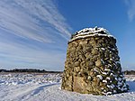 Upload another image | |
| Nairn Viaduct over River Nairn, otherwise known as Culloden Moor Viaduct | Clava, Culloden | NH7641344972 | 57°28′41″N 4°03′46″W / 57.478098°N 4.062705°W | [41] | 1709 |  Upload another image | |
| Dalcross Castle | Dalcross, Croy | NH7786048289 | 57°30′30″N 4°02′25″W / 57.508266°N 4.040252°W | [42] | 1713 |  Upload another image | |
| Fort George | Ardersier, Inverness | NH7607956674 | 57°34′59″N 4°04′27″W / 57.58305°N 4.07423°W | [43] | 1721 |  Upload another image | |
| Budgate House | Cawdor | NH8361149491 | 57°31′14″N 3°56′42″W / 57.520572°N 3.944903°W | [44] | 1727 |  Upload another image | |
| Cawdor Castle | Cawdor | NH8471849870 | 57°31′27″N 3°55′36″W / 57.524257°N 3.926612°W | [45] | 1728 |  Upload another image | |
| Cawdor Parish Church | Cawdor | NH8436149947 | 57°31′29″N 3°55′57″W / 57.524858°N 3.932606°W | [46] | 1760 |  Upload another image | |
| Coul House | Contin | NH4624956404 | 57°34′17″N 4°34′21″W / 57.571457°N 4.572446°W | [47] | 1769 |  Upload another image | |
| Contin Bridge over the Black Water | Contin | NH4540356672 | 57°34′25″N 4°35′12″W / 57.573573°N 4.586746°W | [48] | 1789 |  Upload another image | |
| Canisbay Parish Church (St Drostan's) | Canisbay | ND3434972853 | 58°38′19″N 3°07′57″W / 58.638569°N 3.132592°W | [49] | 1795 |  Upload another image | |
| Castle of Mey | Mey | ND2903273889 | 58°38′49″N 3°13′28″W / 58.647032°N 3.224483°W | [50] | 1797 | 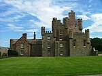 Upload another image | |
| Freswick House | Freswick | ND3780167142 | 58°35′16″N 3°04′18″W / 58.587798°N 3.07157°W | [51] | 1799 |  Upload another image | |
| Holme Rose | Croy | NH8065248630 | 57°30′43″N 3°59′38″W / 57.512072°N 3.993851°W | [52] | 1812 |  Upload another image | |
| Cromarty House | Cromarty | NH7929567018 | 57°40′36″N 4°01′32″W / 57.676777°N 4.025647°W | [53] | 1818 |  Upload another image | |
| Cromarty House, Stables | Cromarty | NH7938566857 | 57°40′31″N 4°01′27″W / 57.675356°N 4.024058°W | [54] | 1820 |  Upload another image | |
| Kilravock Castle | Croy | NH8140949361 | 57°31′08″N 3°58′54″W / 57.518833°N 3.98158°W | [55] | 1841 |  Upload another image | |
| White Bridge over River Nairn | Clephanton | NH8242150223 | 57°31′37″N 3°57′54″W / 57.526835°N 3.965112°W | [56] | 1843 | 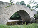 Upload another image | |
| Fort Augustus Abbey | Fort Augustus | NH3814809154 | 57°08′41″N 4°40′36″W / 57.144664°N 4.676667°W | [57] | 1861 |  Upload another image | |
| Fort Augustus Abbey Church | Fort Augustus | NH3814809154 | 57°08′41″N 4°40′36″W / 57.144664°N 4.676667°W | [58] | 1862 | Upload Photo | |
| Oich Old Bridge over River Oich | Aberchalder | NH3376603612 | 57°05′36″N 4°44′43″W / 57.093372°N 4.745313°W | [59] | 1872 |  Upload another image | |
| Old Bridge over River Foyers, Whitebridge | Whitebridge | NH4891515369 | 57°12′15″N 4°30′10″W / 57.204108°N 4.502683°W | [60] | 1874 |  Upload another image | |
| Dunnet Parish Church (Church Of Scotland) | Dunnet | ND2198771183 | 58°37′17″N 3°20′42″W / 58.621525°N 3.344895°W | [61] | 1888 | 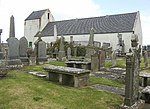 Upload another image | |
| Edderton Old Parish Church and Burial Ground | Edderton | NH7191884231 | 57°49′45″N 4°09′30″W / 57.829237°N 4.158442°W | [62] | 4572 |  Upload another image | |
| Keppoch Barn | Roybridge | NN2695380925 | 56°53′14″N 4°50′31″W / 56.88731°N 4.842039°W | [63] | 6837 | Upload Photo | |
| Commando Memorial | Spean Bridge | NN2078882369 | 56°53′53″N 4°56′39″W / 56.897923°N 4.944103°W | [64] | 6842 |  Upload another image | |
| Mucomir Bridge over River Lochy | Gairlochy, Caledonian Canal | NN1836083824 | 56°54′36″N 4°59′06″W / 56.910031°N 4.984949°W | [65] | 6868 | Upload Photo | |
| Garvamore Barracks | Garvamore, Laggan | NN5280494305 | 57°00′59″N 4°25′34″W / 57.016326°N 4.425978°W | [66] | 6899 |  Upload another image | |
| Garva Bridge over River Spey (St George's Bridge) | Garvamore, Laggan | NN5217494750 | 57°01′12″N 4°26′12″W / 57.020118°N 4.436605°W | [67] | 6900 | 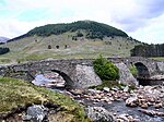 Upload another image | |
| Ardverikie House | Loch Laggan | NN5078987555 | 56°57′18″N 4°27′18″W / 56.955098°N 4.455137°W | [68] | 6910 |  Upload another image | |
| Ardverikie Gate Lodge, gate piers and bridge over River Pattack | Ardverikie House, Loch Laggan | NN5394089689 | 56°58′31″N 4°24′17″W / 56.975257°N 4.404611°W | [69] | 6911 |  Upload another image | |
| Cluny Castle | Balgowan, Laggan | NN6456894290 | 57°01′11″N 4°13′57″W / 57.019794°N 4.232388°W | [70] | 6914 |  Upload another image | |
| Plockton Church and Graveyard | Plockton, Innes Street | NG8027933303 | 57°20′14″N 5°39′09″W / 57.337127°N 5.652572°W | [71] | 6927 |  Upload another image | |
| 12 Lower Ardelve | Ardelve | NG8741326671 | 57°16′52″N 5°31′43″W / 57.281048°N 5.528586°W | [72] | 6999 |  Upload another image | |
| Mound Bridge and Keeper's Cottage | The Mound, Loch Fleet | NH7754998219 | 57°57′23″N 4°04′15″W / 57.956372°N 4.070904°W | [73] | 7022 |  Upload another image | |
| St Andrew's Parish Church | Golspie, Main Street | NC8377500225 | 57°58′34″N 3°58′00″W / 57.976049°N 3.966753°W | [74] | 7036 |  Upload another image | |
| Dunrobin Castle | Golspie | NC8504900820 | 57°58′54″N 3°56′44″W / 57.981721°N 3.945517°W | [75] | 7044 |  Upload another image | |
| Dunrobin Castle, Garden Pavilion (Museum) and Walled Garden | Golspie | NC8518000774 | 57°58′53″N 3°56′36″W / 57.981342°N 3.943281°W | [76] | 7045 |  Upload another image | |
| Caledonian Canal, Glen Loy Aqueduct over the River Loy | Strone, Muirshearlich | NN1492181771 | 56°53′25″N 5°02′23″W / 56.890254°N 5.039845°W | [77] | 7085 |  Upload another image | |
| Caledonian Canal sluice by Carn Phail | Strone, Muirshearlich | NN1488681251 | 56°53′08″N 5°02′24″W / 56.885575°N 5.04004°W | [78] | 7089 |  Upload another image | |
| Caledonian Canal, Torcastle Aqueduct over the Allt Sheangain | Torcastle, Muirshearlich | NN1318279159 | 56°51′58″N 5°03′59″W / 56.866126°N 5.066425°W | [79] | 7090 |  Upload another image | |
| Callert House | Loch Leven | NN0914160401 | 56°41′46″N 5°07′07″W / 56.696219°N 5.118604°W | [80] | 7091 |  Upload another image | |
| Fasnakyle Power Station | Cannich | NH3186729626 | 57°19′34″N 4°47′39″W / 57.326087°N 4.794209°W | [81] | 7118 |  Upload another image | |
| Glen Affric Lodge | Glen Affric | NH1841222919 | 57°15′39″N 5°00′45″W / 57.260765°N 5.012421°W | [82] | 7121 |  Upload another image | |
| Beauly Priory | Beauly | NH5275846489 | 57°29′05″N 4°27′28″W / 57.484647°N 4.457732°W | [83] | 7129 |  Upload another image | |
| Loth Parish Church | Lothmore, Helmsdale | NC9709311380 | 58°04′46″N 3°44′48″W / 58.079476°N 3.746584°W | [84] | 7149 |  Upload another image | |
| Bighouse, Garden Pavilion and Walled Garden | Melvich | NC8920164831 | 58°33′27″N 3°54′22″W / 58.557371°N 3.905973°W | [85] | 7160 | Upload Photo | |
| Croick Parish Church and Burial Ground | Croick, Strathcarron, Bonar Bridge | NH4568291476 | 57°53′09″N 4°36′16″W / 57.885964°N 4.604445°W | [86] | 7181 |  Upload another image | |
| Helmsdale Bridge over River Helmsdale | Helmsdale | ND0258915383 | 58°07′00″N 3°39′18″W / 58.116657°N 3.655103°W | [87] | 7193 |  Upload another image | |
| Eilean Donan Castle | Dornie, Loch Duich | NG8812725836 | 57°16′26″N 5°30′58″W / 57.273894°N 5.516051°W | [88] | 7209 |  Upload another image | |
| Glenelg War Memorial | Glenelg | NG8097219198 | 57°12′40″N 5°37′43″W / 57.211013°N 5.628607°W | [89] | 7236 |  Upload another image | |
| 40 Bornesketaig, Beaton's Cottage | Bornesketaig, Skye | NG3780670740 | 57°39′00″N 6°23′47″W / 57.649996°N 6.39635°W | [90] | 7240 | 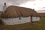 Upload another image | |
| Bernera Barracks | Glenelg | NG8151819741 | 57°12′58″N 5°37′12″W / 57.216142°N 5.620063°W | [91] | 7252 | 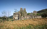 Upload another image | |
| New Kelso House | Strathcarron | NG9397842854 | 57°25′45″N 5°26′00″W / 57.429162°N 5.433431°W | [92] | 7262 | Upload Photo | |
| Ruthven Barracks | Ruthven, Kingussie | NN7647399756 | 57°04′20″N 4°02′21″W / 57.072207°N 4.039132°W | [93] | 7659 |  Upload another image | |
| Auchindrean Bridge, over River Broom | Auchindrean | NH1953880589 | 57°46′43″N 5°02′11″W / 57.778512°N 5.036505°W | [94] | 7754 | 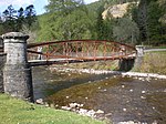 Upload another image | |
| Former Ullapool Parish Church and Burial Ground | Ullapool, West Argyle Street | NH1268593998 | 57°53′45″N 5°09′44″W / 57.895958°N 5.162084°W | [95] | 7764 |  Upload another image | |
| Fearn Abbey | Fearn Abbey | NH8374077288 | 57°46′13″N 3°57′22″W / 57.770141°N 3.956134°W | [96] | 7780 |  Upload another image | |
| Old Wardlaw Church, with Lovat Burial Aisle and Burial Ground | Kirkhill | NH5496745705 | 57°28′42″N 4°25′14″W / 57.478323°N 4.420457°W | [97] | 7815 |  Upload another image | |
| Castle Leod | Strathpeffer | NH4860359325 | 57°35′54″N 4°32′06″W / 57.598464°N 4.534954°W | [98] | 7826 |  Upload another image | |
| Tarbat House | Milton | NH7701373611 | 57°44′07″N 4°04′02″W / 57.73534°N 4.067255°W | [99] | 7848 |  Upload another image | |
| Kilmuir Easter Parish Church and Burial Ground | Kilmuir Easter | NH7575673194 | 57°43′53″N 4°05′17″W / 57.731251°N 4.088134°W | [100] | 7876 |  Upload another image | |
| Udrigle House | Achgarve | NG8956993617 | 57°52′56″N 5°33′03″W / 57.882245°N 5.550953°W | [101] | 7902 |  Upload another image | |
| Wyvis Lodge | Loch Glass, Evanton | NH4849173661 | 57°43′37″N 4°32′45″W / 57.727069°N 4.545828°W | [102] | 7906 |  Upload another image | |
| Flowerdale House (including Westerdale) | Charlestown, Wester Ross | NG8141575364 | 57°42′53″N 5°40′17″W / 57.714717°N 5.671488°W | [103] | 7910 |  Upload another image | |
| Foulis Castle | Evanton | NH5893164107 | 57°38′41″N 4°21′54″W / 57.644728°N 4.3651°W | [104] | 7911 |  Upload another image | |
| Foulis Point Granary | Evanton | NH5996463589 | 57°38′25″N 4°20′51″W / 57.640401°N 4.34751°W | [105] | 7914 | 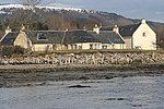 Upload another image | |
| The Corr | Latheron | ND2025035706 | 58°18′10″N 3°21′45″W / 58.302676°N 3.362412°W | [106] | 7935 |  Upload another image | |
| Dunbeath Castle | Dunbeath | ND1580128264 | 58°14′06″N 3°26′08″W / 58.235026°N 3.43559°W | [107] | 7936 | 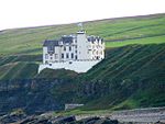 Upload another image | |
| Forse House Dovecote | Latheron | ND2115635361 | 58°17′59″N 3°20′49″W / 58.299742°N 3.346841°W | [108] | 7949 | Upload Photo | |
| Laidhay Croft Museum | Dunbeath | ND1739530541 | 58°15′21″N 3°24′33″W / 58.255773°N 3.409265°W | [109] | 7951 |  Upload another image | |
| Kilcoy Castle | Muir of Ord | NH5766251236 | 57°31′44″N 4°22′44″W / 57.528816°N 4.378784°W | [110] | 8007 | Upload Photo | |
| Old Allangrange House | Munlochy | NH6244351390 | 57°31′54″N 4°17′57″W / 57.531677°N 4.2991°W | [111] | 8013 |  Upload another image | |
| Dochfour House | Dochgarroch | NH6045739204 | 57°25′18″N 4°19′31″W / 57.421698°N 4.325276°W | [112] | 8028 |  Upload another image | |
| Culloden House | Culloden | NH7210746479 | 57°29′26″N 4°08′07″W / 57.49043°N 4.13525°W | [113] | 8039 |  Upload another image | |
| Inshes House, tower house in grounds | Inshes, Inverness | NH6950343692 | 57°27′53″N 4°10′38″W / 57.464672°N 4.177166°W | [114] | 8050 | Upload Photo | |
| Leys Castle | Milton of Leys | NH6800840986 | 57°26′24″N 4°12′02″W / 57.43995°N 4.200609°W | [115] | 8053 | Upload Photo | |
| Beaufort Castle | Beauly | NH5067343006 | 57°27′10″N 4°29′25″W / 57.452708°N 4.490345°W | [116] | 8068 |  Upload another image | |
| Lovat Bridge over River Beauly | Beauly | NH5161544964 | 57°28′14″N 4°28′33″W / 57.470588°N 4.475851°W | [117] | 8083 |  Upload another image | |
| Culloden House, Stables and Yard Wall | Culloden | NH7206846262 | 57°29′18″N 4°08′09″W / 57.488472°N 4.135786°W | [118] | 10954 |  Upload another image | |
| Raasay House | Raasay | NG5475036597 | 57°21′13″N 6°04′44″W / 57.353631°N 6.078883°W | [119] | 13932 |  Upload another image | |
| Ardtornish Tower, Mansion and Clock Tower | Lochaline | NM7032747531 | 56°33′48″N 5°44′23″W / 56.563385°N 5.739641°W | [120] | 13951 | 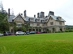 Upload another image | |
| Armadale Castle Stables | Armadale, Skye | NG6387404371 | 57°04′11″N 5°53′49″W / 57.069641°N 5.897006°W | [121] | 14004 |  Upload another image | |
| Fairburn Tower | Marybank | NH4695252356 | 57°32′07″N 4°33′29″W / 57.535371°N 4.558155°W | [122] | 14030 |  Upload another image | |
| Nigg Parish Church (Church of Scotland) and Graveyard | Nigg | NH8044171708 | 57°43′09″N 4°00′32″W / 57.719184°N 4.008774°W | [123] | 14044 |  Upload another image | |
| Ackergill Tower | Wick | ND3528454669 | 58°28′32″N 3°06′41″W / 58.47543°N 3.111305°W | [124] | 14072 |  Upload another image | |
| Keiss Harbour and Warehouse | Keiss | ND3510160877 | 58°31′52″N 3°06′58″W / 58.531147°N 3.116211°W | [125] | 14085 |  Upload another image | |
| Noss Head Lighthouse | Wick | ND3881255012 | 58°28′44″N 3°03′03″W / 58.47902°N 3.050919°W | [126] | 14087 |  Upload another image | |
| Sibster Farm Steading | Sibster, Wick | ND3230752994 | 58°27′36″N 3°09′43″W / 58.459938°N 3.16184°W | [127] | 14088 | Upload Photo | |
| Southern Warehouse (Telford House) | Portmahomack, Harbour Street | NH9155184647 | 57°50′17″N 3°49′42″W / 57.838165°N 3.828241°W | [128] | 14091 |  Upload another image | |
| Tarbat Ness Lighthouse | Portmahomack | NH9469587559 | 57°51′54″N 3°46′36″W / 57.865059°N 3.776605°W | [129] | 14100 |  Upload another image | |
| Ballone Castle | Portmahomack | NH9288183728 | 57°49′49″N 3°48′20″W / 57.830235°N 3.80544°W | [130] | 14104 |  Upload another image | |
| Kinloch Castle | Isle of Rùm | NM4016399544 | 57°00′49″N 6°16′55″W / 57.013644°N 6.281993°W | [131] | 14125 | 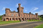 Upload another image | |
| Aultnaslanach Viaduct (or Moy Viaduct) over Allt na Slanaich | Moy | NH7601034937 | 57°23′16″N 4°03′52″W / 57.387906°N 4.06434°W | [132] | 14887 |  Upload another image | |
| Kinkell Castle | Conon Bridge | NH5538854333 | 57°33′21″N 4°25′07″W / 57.555889°N 4.418565°W | [133] | 14906 |  Upload another image | |
| Castle Craig (or Castlecraig) | Culbokie, Black Isle | NH6320063813 | 57°38′36″N 4°17′37″W / 57.643406°N 4.293478°W | [134] | 14938 |  Upload another image | |
| Newhall House | Balblair, Black Isle | NH6983965568 | 57°39′40″N 4°11′00″W / 57.661126°N 4.183296°W | [135] | 14942 |  Upload another image | |
| Poyntzfield House | Jemimaville, Black Isle | NH7106764259 | 57°38′59″N 4°09′43″W / 57.64973°N 4.162031°W | [136] | 14949 |  Upload another image | |
| Achingale Mill | Watten, Caithness | ND2405353471 | 58°27′46″N 3°18′12″W / 58.462861°N 3.303417°W | [137] | 14976 |  Upload another image | |
| Sandside House Kiln Barn, and single storey range of former byres, cottage and dairy, and implement shed | Reay, Caithness | NC9521665234 | 58°33′45″N 3°48′10″W / 58.56248°N 3.802842°W | [138] | 14986 | Upload Photo | |
| Sandside Harbour and Fishing Store | Fresgoe, Caithness | NC9581966070 | 58°34′12″N 3°47′34″W / 58.570129°N 3.792866°W | [139] | 14988 |  Upload another image | |
| Reay Parish Church | Reay, Caithness | NC9673364822 | 58°33′33″N 3°46′36″W / 58.559145°N 3.776593°W | [140] | 14992 |  Upload another image | |
| Torgoyle Bridge (or Torgyle Bridge) over River Moriston | Glenmoriston | NH3090912923 | 57°10′33″N 4°47′55″W / 57.175872°N 4.798707°W | [141] | 14996 |  Upload another image | |
| Corrimony Grange Barn | Corrimony, Glenurquhart | NH3770030435 | 57°20′08″N 4°41′53″W / 57.335459°N 4.697984°W | [142] | 14997 | Upload Photo | |
| Invermoriston Home Farm | Invermoriston | NH4311116515 | 57°12′45″N 4°35′58″W / 57.212442°N 4.599374°W | [143] | 15021 | Upload Photo | |
| Ardross Castle | Ardross | NH6113674118 | 57°44′07″N 4°20′02″W / 57.735259°N 4.333966°W | [144] | 15031 |  Upload another image | |
| Old Rosskeen Parish Church and Burial Ground | Rosskeen, Invergordon | NH6883769250 | 57°41′38″N 4°12′07″W / 57.693883°N 4.20208°W | [145] | 15040 |  Upload another image | |
| Castle Stuart | Tornagrain | NH7415949797 | 57°31′15″N 4°06′10″W / 57.520789°N 4.102756°W | [146] | 17591 |  Upload another image | |
| Tongue Parish Church | Tongue, Sutherland | NC5908657041 | 58°28′44″N 4°25′06″W / 58.478755°N 4.418256°W | [147] | 18456 |  Upload another image | |
| Tongue House | Tongue, Sutherland | NC5916158752 | 58°29′39″N 4°25′05″W / 58.494132°N 4.418026°W | [148] | 18458 | Upload Photo | |
| The Gardener's House | Cromarty, Black Isle | NH7929767213 | 57°40′43″N 4°01′33″W / 57.678528°N 4.025711°W | [149] | 23570 | 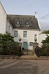 Upload another image | |
| Court House, Prison and Gatepiers | Cromarty, Church Street | NH7897767390 | 57°40′48″N 4°01′52″W / 57.680031°N 4.031162°W | [150] | 23585 |  Upload another image | |
| Miller House | Cromarty, Church Street | NH7899667390 | 57°40′48″N 4°01′51″W / 57.680036°N 4.030844°W | [151] | 23587 | Upload Photo | |
| Hugh Miller's Cottage | Cromarty, Church Street | NH7899967381 | 57°40′48″N 4°01′51″W / 57.679956°N 4.030789°W | [152] | 23588 |  Upload another image | |
| East Parish Church | Cromarty, Church Street | NH7909567267 | 57°40′44″N 4°01′45″W / 57.678958°N 4.029123°W | [153] | 23595 |  Upload another image | |
| Lighthouse and Lighthouse Keeper's House | Cromarty, George Street | NH7867067735 | 57°40′59″N 4°02′11″W / 57.683045°N 4.03648°W | [154] | 23680 |  Upload another image | |
| Townlands Barn | Cromarty, High Street | NH7873967457 | 57°40′50″N 4°02′07″W / 57.680568°N 4.035184°W | [155] | 23695 |  Upload another image | |
| Cromarty Harbour | Cromarty, Marine Terrace | NH7854067723 | 57°40′58″N 4°02′19″W / 57.682902°N 4.038653°W | [156] | 23700 |  Upload another image | |
| St Clements Church | Dingwall, Church Street | NH5493458961 | 57°35′50″N 4°25′44″W / 57.597277°N 4.428912°W | [157] | 24516 |  Upload another image | |
| Caisteal Gorach | Dingwall | NH5444861131 | 57°37′00″N 4°26′18″W / 57.616594°N 4.438339°W | [158] | 24520 | 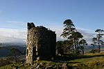 Upload another image | |
| Dornoch Cathedral | Dornoch, High Street | NH7972089692 | 57°52′50″N 4°01′48″W / 57.880424°N 4.029919°W | [159] | 24632 |  Upload another image | |
| Roman Catholic Church of St. Mary and the Immaculate Conception | Fort William, Belford Road | NN1068574110 | 56°49′11″N 5°06′13″W / 56.819823°N 5.103568°W | [160] | 31780 |  Upload another image | |
| St Andrew's Episcopal Church | Fort William, High Street | NN1036174005 | 56°49′07″N 5°06′32″W / 56.818749°N 5.108789°W | [161] | 31788 |  Upload another image | |
| Chanonry Lighthouse | Chanonry Point | NH7492955708 | 57°34′27″N 4°05′35″W / 57.574062°N 4.092951°W | [162] | 31799 | 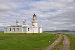 Upload another image | |
| Fortrose Cathedral | Fortrose | NH7270556522 | 57°34′51″N 4°07′50″W / 57.580747°N 4.130537°W | [163] | 31812 |  Upload another image | |
| Speyside House (former orphanage) | Grantown-on-Spey, The Square | NJ0336327912 | 57°19′53″N 3°36′24″W / 57.331463°N 3.60677°W | [164] | 34073 |  Upload another image | |
| 28-34 (even nos only) Academy Street (National Bank Of Scotland) | Inverness, Academy Street | NH6672645421 | 57°28′46″N 4°13′28″W / 57.479383°N 4.224366°W | [165] | 35127 |  Upload another image | |
| Inverness Town Steeple | Inverness, Bridge Street | NH6664745218 | 57°28′39″N 4°13′32″W / 57.477538°N 4.225571°W | [166] | 35153 |  Upload another image | |
| Inverness Sheriff Court and Police Station (Inverness Castle) | Inverness, Castle Wynd | NH6663645116 | 57°28′36″N 4°13′33″W / 57.476619°N 4.225699°W | [167] | 35166 |  Upload another image | |
| Old High Church | Inverness, Church Street | NH6646345514 | 57°28′49″N 4°13′44″W / 57.480141°N 4.228799°W | [168] | 35179 | 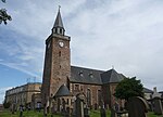 Upload another image | |
| Dunbar's Hospital | Inverness, Church Street | NH6651745498 | 57°28′48″N 4°13′40″W / 57.480013°N 4.22789°W | [169] | 35184 |  Upload another image | |
| 9 and 11 High Street, Bank Of Scotland (former Caledonian Bank head office) | Inverness, High Street | NH6667645251 | 57°28′40″N 4°13′30″W / 57.477843°N 4.225106°W | [170] | 35251 |  Upload another image | |
| Inverness Post Office | Inverness, High Street | 22/12/1976 | NH6680345260 | 57°28′41″N 4°13′23″W / 57.477961°N 4.222995°W | [171] | 35259 |  Upload another image |
| Inverness Town House | Inverness, High Street | NH6668045186 | 57°28′38″N 4°13′30″W / 57.477261°N 4.225004°W | [172] | 35260 | 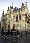 Upload another image | |
| St Mary's Roman Catholic Church | Inverness, Huntly Street | NH6637845266 | 57°28′40″N 4°13′48″W / 57.47789°N 4.23008°W | [173] | 35272 |  Upload another image | |
| Balnain House | Inverness, Huntly Street | NH6631245365 | 57°28′44″N 4°13′52″W / 57.478759°N 4.231234°W | [174] | 35276 |  Upload another image | |
| Inverness Public Library, former Farraline Park School | Inverness, Margaret Street | NH6672345606 | 57°28′52″N 4°13′28″W / 57.481043°N 4.224517°W | [175] | 35311 | 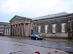 Upload another image | |
| Cathedral Church of St Andrew (Episcopal) | Inverness, Ardross Street | NH6642144883 | 57°28′28″N 4°13′45″W / 57.474465°N 4.229154°W | [176] | 35330 |  Upload another image | |
| Nairn Old Parish Church | Nairn, Academy Street | NH8791656405 | 57°35′01″N 3°52′35″W / 57.58373°N 3.876261°W | [177] | 38400 |  Upload another image | |
| Marine Road, Bandstand | Nairn, Marine Road | NH8823156861 | 57°35′16″N 3°52′16″W / 57.587902°N 3.871206°W | [178] | 38450 | 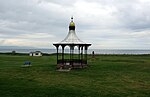 Upload another image | |
| St Duthus Collegiate Church | Tain, Castle Brae | NH7801582187 | 57°48′45″N 4°03′17″W / 57.812594°N 4.054807°W | [179] | 41843 |  Upload another image | |
| Tolbooth and Sheriff Court | Tain, High Street | NH7800382124 | 57°48′43″N 4°03′18″W / 57.812026°N 4.054977°W | [180] | 41867 |  Upload another image | |
| Wick Heritage Centre | Wick, Bank Row | 14/09/1983 | ND3652550671 | 58°26′23″N 3°05′20″W / 58.439713°N 3.088922°W | [181] | 42286 | 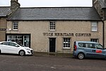 Upload another image |
| Dunbar Memorial, Wick Old Parish Church | Wick, High Street | ND3618851137 | 58°26′38″N 3°05′41″W / 58.443848°N 3.094823°W | [182] | 44956 | Upload Photo | |
| Road Viaduct at Leven Road | Kinlochleven, Leven Road | NN1827661893 | 56°42′48″N 4°58′15″W / 56.713248°N 4.970705°W | [183] | 46265 | Upload Photo | |
| Kinlochleven Aluminium Works, Power House | Kinlochleven | NN1905061826 | 56°42′47″N 4°57′29″W / 56.712947°N 4.958031°W | [184] | 49944 |  Upload another image | |
| Eden Court Theatre | Inverness, Bishop's Road | NH6631644732 | 57°28′23″N 4°13′51″W / 57.473078°N 4.230821°W | [185] | 49959 |  Upload another image |
See also edit
Notes edit
- ^ Sometimes known as OSGB36, the grid reference (where provided) is based on the British national grid reference system used by the Ordnance Survey.
• "Guide to National Grid". Ordnance Survey. Retrieved 12 December 2007.
• "Get-a-map". Ordnance Survey. Retrieved 17 December 2007. - ^ Historic Environment Scotland assign a unique alphanumeric identifier to each designated site in Scotland, for listed buildings this always begins with "LB", for example "LB12345".
Citations edit
- ^ Guide to the Protection of Scotland's Listed Buildings (PDF). Historic Scotland. 2009. p. 4. ISBN 978-1-84917-013-0. Retrieved 5 May 2010.
- ^ "What is Listing?". Historic Scotland. Retrieved 5 May 2010.
- ^ a b Scottish Historic Environment Policy (PDF). Historic Scotland. October 2008. pp. 24–25. ISBN 978-1-84917-002-4. Retrieved 5 May 2010.
- ^ Guide to the Protection of Scotland's Listed Buildings, p. 17.
- ^ "Sluggan Bridge Over River Dulnain: Listed Building Report". Historic Scotland.
- ^ "Muckrach Castle: Listed Building Report". Historic Scotland.
- ^ "Rothiemurchus, Croft House: Listed Building Report". Historic Scotland.
- ^ "Aviemore Railway Station With Island Platform, Footbridge And Fencing: Listed Building Report". Historic Scotland.
- ^ "Broomhill Bridge Over River Spey: Listed Building Report". Historic Scotland.
- ^ "Shin Viaduct Over Kyle Of Sutherland: Listed Building Report". Historic Scotland.
- ^ "Arisaig, Borrodale Railway Viaduct Over The Borrodale Burn: Listed Building Report". Historic Scotland.
- ^ "Castle Tiorim (Eilean Tiorim): Listed Building Report". Historic Scotland.
- ^ "Eilean Fhianain, St Finnan's Chapel And Burial Ground: Listed Building Report". Historic Scotland.
- ^ "Glenfinnan Monument: Listed Building Report". Historic Scotland.
- ^ "Glenfinnan Railway Viaduct Over River Finnan: Listed Building Report". Historic Scotland.
- ^ "Kinlochmoidart House: Listed Building Report". Historic Scotland.
- ^ "(Old) Spey Bridge Over River Spey: Listed Building Report". Historic Scotland.
- ^ "Castle Grant: Listed Building Report". Historic Scotland.
- ^ "Castle Grant, East Lodge. Railway Bridge Over A939 Road And Entrance Arch To Drive.: Listed Building Report". Historic Scotland.
- ^ "Rosehaugh Estate The Dairy: Listed Building Report". Historic Scotland.
- ^ "Glendale Mill And Kiln (Now Museum): Listed Building Report". Historic Scotland.
- ^ "Cape Wrath Lighthouse And Keepers' Cottages: Listed Building Report". Historic Scotland.
- ^ "Dunvegan Parish Church (Church Of Scotland): Listed Building Report". Historic Scotland.
- ^ "Dunvegan Castle, Approach Causeway And Bridges: Listed Building Report". Historic Scotland.
- ^ "Dunvegan Castle The Laundry: Listed Building Report". Historic Scotland.
- ^ "Balnakeil House, Walled Garden, Enclosing Walls And Gate Piers: Listed Building Report". Historic Scotland.
- ^ "Ardnamurchan Lighthouse, Keepers' Houses, Sundial Former Steading And Enclosing Perimeter Wall: Listed Building Report". Historic Scotland.
- ^ "Glenborrodale Castle Hotel, Garden Terraces, Stables And Walled Garden: Listed Building Report". Historic Scotland.
- ^ "Kilchoan, Mingary Castle: Listed Building Report". Historic Scotland.
- ^ "Aldourie Castle: Listed Building Report". Historic Scotland.
- ^ "Nethy Bridge, Aultmore House Garden Pavilions Terrace Walls And Walled Garden: Listed Building Report". Historic Scotland.
- ^ "Ardclach Bell Tower: Listed Building Report". Historic Scotland.
- ^ "Dulsie Bridge (Over River Findhorn): Listed Building Report". Historic Scotland.
- ^ "Glenferness House: Listed Building Report". Historic Scotland.
- ^ "Logie Bridge, Ferness (Over River Findhorn): Listed Building Report". Historic Scotland.
- ^ "Skibo Castle And Garden Terraces, Walled Garden And Glasshouses: Listed Building Report". Historic Scotland.
- ^ "Embo House: Listed Building Report". Historic Scotland.
- ^ "Boath House: Listed Building Report". Historic Scotland.
- ^ "Brightmony House, Garden Walls With Garden House And Pair Gate Piers: Listed Building Report". Historic Scotland.
- ^ "Culloden Moor, Memorial Cairn: Listed Building Report". Historic Scotland.
- ^ "Clava, Nairn Viaduct Over The Nairn River, Otherwise Known As Culloden Moor Viaduct: Listed Building Report". Historic Scotland.
- ^ "Dalcross Castle And Garden Wall: Listed Building Report". Historic Scotland.
- ^ "Fort George: Listed Building Report". Historic Scotland.
- ^ "Budgate House: Listed Building Report". Historic Scotland.
- ^ "Cawdor Castle: Listed Building Report". Historic Scotland.
- ^ "Cawdor Village Cawdor Parish Church And Burial Ground: Listed Building Report". Historic Scotland.
- ^ "Coul House Hotel Formerly Coul House: Listed Building Report". Historic Scotland.
- ^ "Contin Bridge Over River Black Water: Listed Building Report". Historic Scotland.
- ^ "Canisbay Parish Church, Kirkstyle And Burial Ground. (St Drostan's Church Of Scotland): Listed Building Report". Historic Scotland.
- ^ "Castle Of Mey And Garden Walls: Listed Building Report". Historic Scotland.
- ^ "Freswick House Courtyard Walls: Listed Building Report". Historic Scotland.
- ^ "Holme Rose: Listed Building Report". Historic Scotland.
- ^ "Cromarty House: Listed Building Report". Historic Scotland.
- ^ "Cromarty House Stables: Listed Building Report". Historic Scotland.
- ^ "Kilravock Castle, Dovecote And Garden Walls: Listed Building Report". Historic Scotland.
- ^ "White Bridge By Clephanton Over River Nairn: Listed Building Report". Historic Scotland.
- ^ "Fort Augustus Abbey, Monastery And School: Listed Building Report". Historic Scotland.
- ^ "Fort Augustus Abbey Church: Listed Building Report". Historic Scotland.
- ^ "Oich, Old Bridge Over River Oich: Listed Building Report". Historic Scotland.
- ^ "Whitebridge, Old Bridge Over River Foyers: Listed Building Report". Historic Scotland.
- ^ "Dunnet Parish Church (Church Of Scotland) And Burial Ground: Listed Building Report". Historic Scotland.
- ^ "Old Parish Church And Burial Ground: Listed Building Report". Historic Scotland.
- ^ "Roybridge, Keppoch Barn: Listed Building Report". Historic Scotland.
- ^ "Spean Bridge, Commando Memorial: Listed Building Report". Historic Scotland.
- ^ "Gairlochy, Mucomir Bridge Over River Lochy: Listed Building Report". Historic Scotland.
- ^ "Garvamore Barracks: Listed Building Report". Historic Scotland.
- ^ "Garvamore, Garva Bridge Over River Spey (St George's Bridge): Listed Building Report". Historic Scotland.
- ^ "Ardverikie House, Outbuildings, Game Larders, Boat House And Walled Garden: Listed Building Report". Historic Scotland.
- ^ "Ardverikie Gate Lodge, Gate Piers And Bridge Over River Pattack: Listed Building Report". Historic Scotland.
- ^ "Cluny Castle: Listed Building Report". Historic Scotland.
- ^ "Plockton Innes Street Plockton Church (Church Of Scotland) And Graveyard: Listed Building Report". Historic Scotland.
- ^ "Ardelve, 12 Lower Ardelve: Listed Building Report". Historic Scotland.
- ^ "Mound Bridge And Keeper's Cottage: Listed Building Report". Historic Scotland.
- ^ "Golspie Main Street St Andrew's Parish Church (Church Of Scotland And Burial Ground): Listed Building Report". Historic Scotland.
- ^ "Dunrobin Castle: Listed Building Report". Historic Scotland.
- ^ "Dunrobin Castle Garden Pavilion (Museum) And Walled Garden: Listed Building Report". Historic Scotland.
- ^ "Caledonian Canal, Aqueduct Over The River Loy: Listed Building Report". Historic Scotland.
- ^ "Caledonian Canal, Sluice By Carn Phail: Listed Building Report". Historic Scotland.
- ^ "Caledonian Canal, Torcastle Aqueduct Over The Allt Sheangain: Listed Building Report". Historic Scotland.
- ^ "Callert House: Listed Building Report". Historic Scotland.
- ^ "Fasnakyle Power Station: Listed Building Report". Historic Scotland.
- ^ "Glen Affric Lodge: Listed Building Report". Historic Scotland.
- ^ "Beauly Priory: Listed Building Report". Historic Scotland.
- ^ "Loth Parish Church (Church Of Scotland): Listed Building Report". Historic Scotland.
- ^ "Bighouse, Garden Pavilion And Walled Garden: Listed Building Report". Historic Scotland.
- ^ "Strathcarron Croick Parish Church (Church Of Scotland) And Burial Ground: Listed Building Report". Historic Scotland.
- ^ "Helmsdale Bridge Over River Helmsdale: Listed Building Report". Historic Scotland.
- ^ "Eilean Donan Castle: Listed Building Report". Historic Scotland.
- ^ "Glenelg War Memorial: Listed Building Report". Historic Scotland.
- ^ "40 Bornesketaig: Listed Building Report". Historic Scotland.
- ^ "Bernera Barracks: Listed Building Report". Historic Scotland.
- ^ "New Kelso House: Listed Building Report". Historic Scotland.
- ^ "Ruthven Barracks And Stables: Listed Building Report". Historic Scotland.
- ^ "Auchindrean Bridge, Over River Broom: Listed Building Report". Historic Scotland.
- ^ "Ullapool Argyle Street Former Ullapool Parish Church And Burial Ground: Listed Building Report". Historic Scotland.
- ^ "Fearn Abbey (Church Of Scotland Parish Church): Listed Building Report". Historic Scotland.
- ^ "Kirkhill, Old Wardlaw Church With Lovat Burial Aisle And Burial Ground: Listed Building Report". Historic Scotland.
- ^ "Castle Leod: Listed Building Report". Historic Scotland.
- ^ "Tarbat House And Stables: Listed Building Report". Historic Scotland.
- ^ "Kilmuir Easter Parish Church (Church Of Scotland) And Burial Ground: Listed Building Report". Historic Scotland.
- ^ "Udrigle House: Listed Building Report". Historic Scotland.
- ^ "Wyvis Lodge, Stables And Game Larders: Listed Building Report". Historic Scotland.
- ^ "Flowerdale House (Including Westerdale) And Walled Garden: Listed Building Report". Historic Scotland.
- ^ "Foulis Castle: Listed Building Report". Historic Scotland.
- ^ "Foulis Point Granary: Listed Building Report". Historic Scotland.
- ^ "The Corr: Listed Building Report". Historic Scotland.
- ^ "Dunbeath Castle, Walled Gardens And Garden Pavilion: Listed Building Report". Historic Scotland.
- ^ "Forse House Dovecote: Listed Building Report". Historic Scotland.
- ^ "Laidhay Croft Museum Croft House And Barn: Listed Building Report". Historic Scotland.
- ^ "Kilcoy Castle: Listed Building Report". Historic Scotland.
- ^ "Old Allangrange: Listed Building Report". Historic Scotland.
- ^ "Dochfour House: Listed Building Report". Historic Scotland.
- ^ "Culloden House, Gate Piers And Gardeners' Bothy: Listed Building Report". Historic Scotland.
- ^ "Inshes House, Tower House In Grounds: Listed Building Report". Historic Scotland.
- ^ "Leys Castle And Garden Terraces: Listed Building Report". Historic Scotland.
- ^ "Beaufort Castle: Listed Building Report". Historic Scotland.
- ^ "Lovat Bridge Over River Beauly: Listed Building Report". Historic Scotland.
- ^ "Culloden House Stables And Yard Wall: Listed Building Report". Historic Scotland.
- ^ "Raasay House: Listed Building Report". Historic Scotland.
- ^ "Ardtornish Estate Ardtornish Tower, Mansion And Clock Tower: Listed Building Report". Historic Scotland.
- ^ "Armadale Castle Stables: Listed Building Report". Historic Scotland.
- ^ "Fairburn Tower: Listed Building Report". Historic Scotland.
- ^ "Nigg Parish Church (Church Of Scotland) And Graveyard: Listed Building Report". Historic Scotland.
- ^ "Ackergill Tower, Garden Walls, Walled Gardens And Stable Range: Listed Building Report". Historic Scotland.
- ^ "Keiss Harbour And Warehouse: Listed Building Report". Historic Scotland.
- ^ "Noss Head Lighthouse Keepers' Houses And Offices: Listed Building Report". Historic Scotland.
- ^ "Sibster Farm Steading: Listed Building Report". Historic Scotland.
- ^ "Portmahomack Harbour Street Southern Warehouse: Listed Building Report". Historic Scotland.
- ^ "Tarbat Ness Lighthouse, Keepers' Cottages And Enclosing Wall: Listed Building Report". Historic Scotland.
- ^ "Ballone Castle: Listed Building Report". Historic Scotland.
- ^ "Isle Of Rhum, Kinloch Castle: Listed Building Report". Historic Scotland.
- ^ "Moy, Aultnaslanach Viaduct Over Allt Na Slanaich Burn: Listed Building Report". Historic Scotland.
- ^ "Kinkell Castle And Surrounding Wall And Studio Cottage: Listed Building Report". Historic Scotland.
- ^ "Castle Craig: Listed Building Report". Historic Scotland.
- ^ "Newhall: Listed Building Report". Historic Scotland.
- ^ "Poyntzfield House: Listed Building Report". Historic Scotland.
- ^ "Achingale Mill: Listed Building Report". Historic Scotland.
- ^ "Sandside House Kiln Barn And Single Storey Range Of Former Byres, Cottage And Dairy, And Implement Shed: Listed Building Report". Historic Scotland.
- ^ "Sandside Harbour 1 And 2, Sandside And Fishing Store: Listed Building Report". Historic Scotland.
- ^ "Reay Parish Church And Enclosure Wall: Listed Building Report". Historic Scotland.
- ^ "Glenmoriston, Torgoyle Bridge Over River Moriston: Listed Building Report". Historic Scotland.
- ^ "Glenurquhart, Corrimony Grange Barn: Listed Building Report". Historic Scotland.
- ^ "Invermoriston, Home Farm And Former Barn To Rear.: Listed Building Report". Historic Scotland.
- ^ "Ardross Castle, Terraces And Gate Piers: Listed Building Report". Historic Scotland.
- ^ "Old Rosskeen Parish Church And Burial Ground: Listed Building Report". Historic Scotland.
- ^ "Castle Stuart And Gatepiers: Listed Building Report". Historic Scotland.
- ^ "Tongue Parish Church (C Of S ), Burial Ground And Gatepiers: Listed Building Report". Historic Scotland.
- ^ "Tongue House: Listed Building Report". Historic Scotland.
- ^ "Causeway, The Gardener's House And Garden Walls: Listed Building Report". Historic Scotland.
- ^ "Church Street, Court House, Prison And Gatepiers: Listed Building Report". Historic Scotland.
- ^ "Church Street, Miller House: Listed Building Report". Historic Scotland.
- ^ "Church Street, Hugh Miller's Cottage: Listed Building Report". Historic Scotland.
- ^ "Church Street, East Parish Church: Listed Building Report". Historic Scotland.
- ^ "George Street, Lighthouse And Lighthouse Keeper's House: Listed Building Report". Historic Scotland.
- ^ "Cromarty, High Street Townlands Barn: Listed Building Report". Historic Scotland.
- ^ "Cromarty Harbour: Listed Building Report". Historic Scotland.
- ^ "Tulloch Street, St Clements Church (C Of S Parish Church), Gatepiers And Burial Ground: Listed Building Report". Historic Scotland.
- ^ "Caisteal Gorach: Listed Building Report". Historic Scotland.
- ^ "Castle Street Dornoch Cathedral And Walled Grave Yard. (Cathedral Of St. Mary And St Gilbert. Church Of Scotland Parish Church): Listed Building Report". Historic Scotland.
- ^ "Belford Road, Roman Catholic Church Of St. Mary And The Immaculate Conception And Enclosing Walls With Gate Piers.: Listed Building Report". Historic Scotland.
- ^ "High Street, St Andrew's Episcopal Church, Burial Ground, Lych Gate (To High Street) And Entrance To Bank Street: Listed Building Report". Historic Scotland.
- ^ "Chanonry Chanonry Lighthouse, Keeper's House, Wall And Gatepiers: Listed Building Report". Historic Scotland.
- ^ "Fortrose Cathedral Square, Fortrose Cathedral (Ss. Peter And Bonifacius Graveyard And Walls: Listed Building Report". Historic Scotland.
- ^ "The Square Speyside Home (Former Orphanage): Listed Building Report". Historic Scotland.
- ^ "28-34 (Even Nos Only) Academy Street: Listed Building Report". Historic Scotland.
- ^ "2 Bridge Street And Church Street, Town Steeple: Listed Building Report". Historic Scotland.
- ^ "Castle Wynd, Sheriff Court And Police Station, Castle Hill: Listed Building Report". Historic Scotland.
- ^ "Church Street, Old High Church: Listed Building Report". Historic Scotland.
- ^ "86 And 88 Church Street Dunbar's Hospital: Listed Building Report". Historic Scotland.
- ^ "9 And 11 High Street Bank Of Scotland: Listed Building Report". Historic Scotland.
- ^ "54-60 (Even Numbers Only) High Street: Listed Building Report". Historic Scotland.
- ^ "High Street, Town House: Listed Building Report". Historic Scotland.
- ^ "Huntly Street, St Mary's Rc Church: Listed Building Report". Historic Scotland.
- ^ "Huntly Street, Balnain House: Listed Building Report". Historic Scotland.
- ^ "Margaret Street, Former Farraline Park School: Listed Building Report". Historic Scotland.
- ^ "Ness Walk, Cathedral Church Of St Andrew (Episcopal): Listed Building Report". Historic Scotland.
- ^ "Academy Street, Old Parish Church: Listed Building Report". Historic Scotland.
- ^ "Marine Road, Bandstand: Listed Building Report". Historic Scotland.
- ^ "Castle Brae St Duthus Collegiate Church With St Duthus Church, Graveyard And Retaining Wall: Listed Building Report". Historic Scotland.
- ^ "High Street Tolbooth And Sheriff Court: Listed Building Report". Historic Scotland.
- ^ "19 - 27 (Odd) Bank Row (Wick Heritage Centre): Listed Building Report". Historic Scotland.
- ^ "High Street, Wick Old Parish Church Churchyard, Dunbar Memorial: Listed Building Report". Historic Scotland.
- ^ "Kinlochleven, Road Viaduct At Leven Road: Listed Building Report". Historic Scotland.
- ^ "Kinlochleven, Power House: Listed Building Report". Historic Scotland.
- ^ "Ness Walk, Eden Court Theatre Including Sculpture: Listed Building Report". Historic Scotland.