


Summary
This article lists the bridges and tunnels in Dublin and the Greater Dublin Area in Ireland. The bridges are ordered sequentially upstream, from mouth to source. For lists that are not in table format, alternative or historical names are in curved brackets (parentheses) and traversing roads or rails are in square brackets.
Bridges over the Liffey edit
Bridges over the River Liffey in Greater Dublin, from east to west.
| Name | Alternate names | Type | Connections | Build dates | Image |
|---|---|---|---|---|---|
| East-Link Bridge | Tom Clarke Bridge[1] | Tolled drawbridge | East Wall Road to Toll Bridge Road and York Road | 1984 |  |
| Samuel Beckett Bridge | Rotatable road bridge | Guild Street to Sir John Rogerson's Quay | 2009 |  | |
| Seán O'Casey Bridge | Rotatable footbridge | Sir John Rogerson's Quay to North Wall Quay | 2005 |  | |
| Talbot Memorial Bridge | Road bridge | Memorial Road to Moss Street | 1978 |  | |
| Loopline Bridge | Liffey Viaduct | Rail bridge with overhead power supply for the DART | Links suburban and intercity rail lines south of Liffey to those in the north | 1891 |  |
| Butt Bridge | Irish: Droichead na Comhdhála, meaning "Congress Bridge" | Road bridge | Beresford Place to Tara Street | 1932 (Previous structure: 1879) |  |
| Rosie Hackett Bridge | Working name: Marlborough Street Public Transport Priority Bridge | Road bridge (public transport only) | Marlborough Street to Hawkins Street | 2012–14[2][3] |  |
| O'Connell Bridge | Carlisle Bridge | Road bridge | O'Connell Street Lower to Westmoreland Street and D'Olier Street | 1791 (Original: 1791 Redeveloped: 1879) |  |
| Liffey Bridge | Ha'penny Bridge, Metal Bridge, Wellington Bridge | Foot bridge | Liffey Street Lower to Merchant's Arch | 1816 |  |
| Millennium Bridge | Footbridge | Ormonde Quay to Wellington Quay | 1999 |  | |
| Grattan Bridge | Essex Bridge | Road bridge | Capel Street to Parliament Street | 1874 (Previous structures: 1676, 1755) |  |
| O'Donovan Rossa Bridge | Richmond Bridge, Ormond Bridge | Road bridge | Chancery Place to Winetavern Street | 1816 (Previous structure: 1684) |  |
| Father Mathew Bridge | Whitworth Bridge, Dublin Bridge, Old Bridge | Road bridge | Church Street to Bridge Street Lower | 1818 (Previous structures: 1014, 1428) | 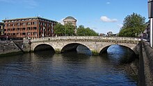 |
| Mellows Bridge | Mellowes Bridge, Queen's Bridge, Queen Maeve Bridge | Road bridge | Queen Street to Bridgefoot Street | 1768 (Previous structure: 1683) |  |
| James Joyce Bridge | Road bridge | Blackhall Place to Ushers Island | 2003 |  | |
| Rory O'More Bridge | Victoria & Albert Bridge, Queen Victoria Bridge | Road bridge | Watling Street to Ellis Street | 1859 (Previous structures: 1670, 1704) |  |
| Frank Sherwin Bridge | Road bridge | St. John's Road West and Victoria Quay to Wolfe Tone Quay | 1981 |  | |
| Seán Heuston Bridge | King's Bridge, Sarsfield Bridge | Light rail and footbridge | Heuston Station to Wolfe Tone Quay | 1828 |  |
| Liffey Railway Bridge | Rail bridge | Heuston Station to Phoenix Park Tunnel | 1877 |  | |
| Islandbridge | Sarah or Sarah's Bridge | Road bridge | South Circular Road to Conyngham Road | 1794 (Previous structure: 1577) |  |
| Anna Livia Bridge | Chapelizod Bridge | Road bridge | Lucan Road to Chapelizod Road | 1753 (Previous structure: 1660s) |  |
| Farmleigh Bridge | Disused service bridge | Farmleigh House | 1850s |  | |
| West-Link Bridge | Tolled motorway bridge | M50 motorway | 1990 |  | |
| Lucan Bridge | Road bridge | Lower Lucan Road | 1814 (Previous structures: 1200s, 1730s, 1771, 1780s) |  |

Bridges over the River Liffey outside Greater Dublin, from east to west.
- Sewage treatment works bridge
- Leixlip Bridge [Leixlip Road]
- M4 motorway
- New Bridge [R404]
- Liffey Bridge (Celbridge Bridge) [Dublin Road, Celbridge]
- A footbridge immediately to the south of the road bridge in Celbridge
- Rock Bridge [footbridge at Celbridge Abbey]
- Straffan Bridge
- A truss bridge just west of Straffan Bridge
- The Bridge at 16 [19th century wrought iron pedestrian suspension bridge crossing the south channel of the river to the 17th tee in the Kildare Hotel and Golf Club]
- A bridge crossing the north channel of the river 60 metres from The Bridge at 16
- An agricultural access bridge west of The K Club
- Alexandra Bridge [Clane]
- Millicent Bridge [near Sallins]
- Leinster Aqueduct[4] Grand Canal crossing

- Railway bridge, MP 19 [Dublin to Cork railway crossing]
- Caragh Bridge [Caragh]
- Victoria Bridge (L2030)
- Newbridge College footbridge
- Saint Conleth's Bridge, Newbridge
- M7 Motorway
- L2032 at Athgarvan
- M9 Motorway
- Castlemartin Bridge
- Kilcullen Bridge or The Bridge, Kilcullen (Bridge), County Kildare
- R412
- Old bridge at Brannockstown
- R411 Ballymore Eustace
- Poulaphouca Bridge
- R758 Burgage Moyle Bridge
- Ballyward Bridge L8375
- Ballusmuttan Bridge L4377
- R759
- Liffey Head Bridge
Bridges on the Grand Canal edit
Bridges on the Grand Canal from the River Liffey to the south and west. In addition, many of the canal locks allow for pedestrian crossing.
| Name | Alternate names | Connections | Notes | Image |
|---|---|---|---|---|
| MacMahon Bridge | Draw Bridge, Brunswick Bascule,[5] Victoria Bridge (1857 and 1900 bridges) | Ringsend Road, Pearse Street - R802 | Named after General Seán Mac Mahon. Rebuilt in 2007. Previous bridges in 1791, 1857, 1900 and 1960[6] (or possibly 1962[7]). |  |
| Victoria Bridge [8] | Rail bridge | Dublin to Rosslare railway line |  | |
| Maquay Bridge | Grand Canal Street - R815 | Named after George Macquay, a director of the Grand Canal Company in 1791. There is not much information on the present bridge, though it is likely to date from the late 1930s like other reconstructed canal bridges in Dublin at that time. |  | |
| Mount Street Bridge | McKenny's Bridge, Conyngham Bridge (original name) | Northumberland Road, Mount Street Lower - R118 | Built in 1791 and widened prior to 1916 and in 1956.[9] Named after Thomas McKenny, a director of the Grand Canal Company in 1791. Scene of the battle of Mount Street Bridge in the Easter Rising. |   |
| Huband Bridge | Mount Street Crescent | Named after Joseph Huband, a director of the Grand Canal Company. Looks more ornate than other bridges as Huband paid for the bridge himself. The bridge was a favourite spot for the poet Patrick Kavanagh. |  | |
| Macartney Bridge | Baggot Street Bridge | Baggot Street - R816 | Built in 1791 and named after George McCartney, chairman of the Grand Canal Company. This area of the canal along towards Leeson Street Bridge was an area often used by sex workers at night. In 1998 a prostitute was murdered over an alleged debt.[10] |  |
| Eustace Bridge | Leeson Street Bridge | Leeson Street - R138 | Built in 1791. Named after Lieutenant Colonel Charles Eustace, M.P. and Deputy Chairman of the Grand Canal Company. Tram tracks were added in 1870 along with an adjacent water mains pipe, bringing water from the Vartry Reservoir scheme.[11] For Queen Victoria's royal visit in 1900 it was decided to greet the queen with an old tradition of a triumphal arch. Originally Balls Bridge was chosen as the location, but the electric tram wires were deemed too high to make it practical, so instead Leeson Street Bridge was selected.[12] The gate, though painted to look like limestone, was actually a wooden structure held in place by guide wires. Similar '30 foot' structures were built for the royal visits in 1903 and 1911. In 1959 there was a proposal to reconstruct the bridge.[13] A number of drownings occurred at this location. |   |
| Luas bridge | Luas Green line | Opened in 2004. Bridge dedicated to Professor Simon H Perry in 2005. Previous railway bridge, Canal Bridge, was dismantled in 1959 when the Harcourt Street line was closed.[14] |  | |
| Charlemont Bridge | Ranelagh Bridge | Ranelagh Road, Charlemont Street - R117 | Often mistakenly called Ranelagh Bridge. Named after the adjoining street. There was a failed assassination attempt by the IRA of General Hugh Tudor in January 1921, as part of the Irish War of Independence. The bridge was reconstructed in 1940.[15] |  |
| La Touche Bridge | Portobello Bridge | Rathmines Road Lower, Richmond Street South - R114 | Built in 1791, named after William Digges La Touche,[16] a director of the Grand Canal Company. In 1861 a horse-drawn carriage fell into the lock with a loss of all 6 passengers and all horses.[17] Tram tracks were first added in 1871,[18] with overhead electricity completed in 1896.[19] During the Easter Rising and Civil War there were a number of events that took place at the bridge due to its strategic location.[20] In 1928 a bridge widening scheme was undertaken jointly by Dublin Corporation and Rathmines Urban District Council, the bridge was widened by 10 feet and steel lock gates were added.[21] Maintenance work was carried out in 2004 (steel parts of bridge replaced). |   |
| Robert Emmet Bridge | Clanbrassil Bridge (original name), Harold's Cross Bridge | Harold's Cross Road, Clanbrassil Street Upper - R137 | The original, Clanbrassil Bridge, was built in 1791 with tram tracks added in 1879 along with a longer approach to the bridge to lessen the gradient.[22] The bridge was rebuilt in 1935-36 and renamed to Emmet Bridge in honour of the rebellion leader Robert Emmet, who was arrested in the vicinity in 1803.[23] There is a ghost bike attached to railings beside the bridge. |  |
| Parnell Bridge | Sally's Bridge | Clogher Road | Built in 1791 and named after John Parnell (the great-great-grandfather of Charles Stewart Parnell),[23] but known generally as Sally's Bridge. The origins of the name are unknown with a number of explanations offered: a local man, John Sally, who had a farm near where Clogher Road now stands; that it got its name from the nearby River Saile or Salach; a 'lady of the night' who worked in the area.[24] In 1938 an Irish Times article suggested the road was once a toll bridge and an old woman called Sally was the toll collector.[25] The road was doubled in width during an upgrade in 1938. |  |
| Camac Bridge | Dolphin's Barn Bridge | Dolphin's Barn, Crumlin Road - R110 | Built in 1791. Named after Turner Camac, a director of the Grand Canal Company. Bridge works were carried out during 1938.[26] Repair works took place in 1964. |  |
| Herberton Bridge | Harberton Bridge | Herberton Road | Named after Lord Viscount Harberton, a director of the Grand Canal Company.[27] The original bridge was replaced by a concrete bridge in 1938.[23] The road was named after the bridge but at some point around 1878, Harberton became Herberton. |  |
| Rialto Bridge | Harcourt Bridge (official name) | Over Luas Red Line South Circular Road - R811 | This was on the former main line of the Grand Canal. During the construction of the canal a temporary wooden bridge was built in 1766.[28] in 1795 an elegant stone bridge was constructed,[29] which lasted until 1939 when a new wider concrete bridge was built. In 1974 the canal section was filled in. When the Luas Red Line was opened in 2004 the bridge was altered with the parapet raised above eye level. Original name of bridge comes from Simon Harcourt, 1st Earl Harcourt, Lord Lieutenant 1772–76. The name Rialto comes from a local area and is not related to the Italian Rialto Bridge. |  |
| Griffith Bridge | Grand Canal View | Named after Richard Griffith, a director in 1791 (father of the late Sir Richard Griffith). Used only as an access road for apartments since the adjacent Suir Road bridge was built in 1938. |  | |
| Ann Devlin Bridge | Luas Bridge | Luas Red Line | Built in 2004 for the Luas Red Line. Named in honour of Irish republican Anne Devlin. The plaque on the bridge spells her name as Ann Devlin, though on her gravestone in Glasnevin Cemetery it is spelled as Anne Devlin. |  |
| Suir Road Bridge | Suir Road - R111 | Built in 1938 as part of a new road in Dublin in the expanding suburbs. |  | |
| Footbridge at Goldenbridge Luas station | Pedestrian access. |  | ||
| Footbridge at Drimnagh Luas station | Pedestrian access. Built in 2004 for opening of Luas Red Line. |  | ||
| Blackhorse Bridge | Kelly's Bridge | Naas Road, Tyrconnell Road - R810 | Upgrade works took place in 1938.[26] |  |
| New Bridge | Kylemore Road - R112 | Built around 1955.[30] Although it has a pedestrian underpass it was not deemed large enough for the greenway. |  | |
| Ballyfermot Bridge | Old Killeen Road | Built around 1775.[31] |  | |
| Killeen Road Bridge | Killeen Road | Has a limited underpass for pedestrians. |  | |
| Park West Avenue | Has a large underpass for pedestrians. |  | ||
| M50 Motorway | Western Parkway Motorway - M50 | Built between 1987 and 1990. Has a large underpass for pedestrians. |  | |
| Clondalkin Bridge | Ninth Lock Bridge | Ninth Lock Road | Repair works in 1951. |  |
| Fonthill Road | R113 |  | ||
| Outer Ring Road | R136 | Built in 2008, has a large underpass. |  | |
| Footbridge | Built in 2008 for the greenway, has a large underpass. |  | ||
| Lucan Road Bridge | 12th Lock Bridge | R120 | Built around 1770, one of the first bridges on the Grand Canal. Widened in 1932 and again in 2020. |  |
| Gollierstown Bridge | Built circa 1780.[32] Damaged in November 1934.[33] Currently used only as farm crossing and is gated to prevent crossing. |  | ||
| Hazelhatch Bridge | R405 |  | ||
| Aylmer's Bridge | Lyons Road - L5064 | Built in 1782 or 1784, depending on sources. Lies on the border between County Kildare and County Dublin. |  |
Bridges on the Royal Canal edit
Bridges on the Royal Canal from the River Liffey to the north and west. Many of the bridges include a rail crossing for the rail lines adjacent to the canal in much of Dublin. In addition, many of the canal locks allow for pedestrian crossing and several pedestrian bridges are located adjacent to Iarnród Éireann railway stations.
- North Wall Quay Scherzer bascule bridge [North Wall Quay - R801]
- Spencer Dock Bridge [Mayor Street] - Luas bridge.
- Sheriff Street Lifting Bridge (inoperable) [Sheriff Street - R101]
- Ossory Road railway bridge (comprising three independent bridge structures) [DART bridge]
- Railway bridge [lifting bridge], sometimes referred to as "Effin bridge".[34][35]
- Newcomen Bridge [North Strand Road - R105]
- Clarke's Bridge [Summerhill Parade, Ballybough Road - R803]
- Footbridge for access to Croke Park
- Clonliffe Bridge (Russell Street Bridge) [Russell Street, Jones's Road]
- Binns Bridge [Drumcondra Road - R132]
- Cross Guns Bridge (Westmoreland Bridge) [Phibsborough Road, Prospect Road - R135]
- Railway bridge at Liffey Junction
- Broom Bridge (Broome Bridge, Brougham Bridge) [Broombridge Road]
- Ratoath Road bridge- R805
- Reilly Bridge (Reily's Bridge)
- Railway tunnel
- Railway bridge at Liffey Junction
- Longford Bridge [Ashtown Road - L3101]
- Dunsink Lane Bridge [New River Road]
- Ranelagh Bridge [disused]
- Roundabout of Junction 6 of M50 motorway - two bridges
- Royal Canal aqueduct over the M50 motorway
- Talbot Bridge [Old Navan Road]
- Granard Bridge [Castleknock Road - R806]
- Kirkpatrick Bridge [Carpenterstown Road, Coolmine Road]
- Dr. Troy Bridge [Diswellstown Road - L3036]
- Porterstown Bridge [Porterstown Road - L3035]
- Kennan Bridge (Neville Bridge) [Porterstown Road]
- Callaghan Bridge (Carhampton Bridge) R121
- Railway bridge
- Pakenham Bridge (Barberstown Bridge)
- Collins Bridge [Barnhill Crossroads - L3005]
- Royal Canal passes into County Kildare
- Cope Bridge [Captain's Hill - R149]
- Royal Canal aqueduct over the Rye Water
- Louisa Bridge R148
- R449
- Deey Bridge
- Pike Bridge [L5053]
- Mullen Bridge [Straffan Road - R406]
- Footbridge
- Bond Bridge [Parson Street, Clane Road - R408]
- Royal Canal aqueduct over the River Lyreen
- Jackson's Bridge
Bridges over the River Dodder edit
Bridges over the River Dodder from the River Liffey to the southwest.
| Name | Alternate names | Connections | Notes | Image |
|---|---|---|---|---|
| Ringsend Bridge | Ringsend Road, Bridge Street - R802 | Opened in 1812.[36] |  | |
| London Bridge | Bath Avenue, Londonbridge Road - R111 | Opened in 1857.[37] Where the Swan River joins. Traffic restricted to single lane by traffic lights. |  | |
| New Bridge | Herbert's Bridge, Lansdowne Bridge | Herbert's Road, Lansdowne Road |  | |
| DART bridge | Dublin to Rosslare railway line | Includes pedestrian crossing. Original bridge built in 1834. |  | |
| Ball's Bridge | Pembroke Road, Merrion Road - R118 | Gives name to the neighbourhood. 1st bridge built in 1751, 2nd bridge built in 1791. 3rd bridge built in 1835, widened and improved in 1904. |  | |
| Bridge at Herbert Park | Connects Herbert Park Hotel to Anglesea Road. |  | ||
| Anglesea Bridge | Stillorgan Bridge | Donnybrook Road, Stillorgan Road - R138 | First bridge built in 1832. |  |
| Footbridge | Beaver Row and Brookvale Road |  | ||
| Clonskeagh Bridge | Clonskeagh Road - R825 |  | ||
| Milltown Bridge | Dundrum Road - R117 | Includes pedestrian underpass. |  | |
| Packhorse Bridge | 1650s stone footbridge at Milltown Road and Bankside Cottages[38] |  | ||
| The Nine Arches Bridge | Luas Bridge | Luas Green Line | Opened in 1859 for Harcourt Street railway line. Closed in 1958 and reopened in 2004 for the Luas. No access for pedestrians. |  |
| Classon's Bridge | Churchtown Road Lower - L3001 | Includes pedestrian underpass. Widened in 1928. |  | |
| Footbridge at Dartry Mills | No public access to bridge. |  | ||
| Footbridge at Dartry Park | Dartry Park |  | ||
| Orwell Bridge[39] | Waldron's Bridge | Orwell Road | Includes pedestrian underpass. First built in 1848, financed by Patrick Waldron.[40] |  |
| Footbridge at Orwell Park |  | |||
| Pearse Bridge | Rathfarnham Road - R114 | First bridge (called Big Bridge) destroyed by a flood in 1754, a new bridge was constructed in 1765. Widened and named in honour of the Pearse brothers in 1953.[41] |  | |
| Dodder Stones | Dodder Valley Park to Bushy Park | Not a bridge but a way for pedestrians to cross the Dodder. |  | |
| Footbridge at Dodder Valley Park near Rathfarnham | Dodder Valley Park |  | ||
| Bridge at Springfield Avenue | Springfield Avenue - R112 | Includes pedestrian underpass. |  | |
| Templeogue Bridge | Old Bridge Road - R817 | Includes pedestrian underpass. |  | |
| Spawell Bridge | Spawell Link Road - L4023 | Opened 5 February 2001. Includes pedestrian underpass. |  | |
| M50 Bridge | M50 | Includes pedestrian underpass. |  | |
| Footbridge near Tymon | Dodder Valley Park and Tymon Park |  | ||
| Dodder Greenway Foot/Cycle Bridge | Avonmore Road | Opened 2021 |  | |
| Dodder Greenway Foot/Cycle Bridge, Firhouse | Old Bawn and Killininny | Opened 14 November 2014 |  | |
| Old Bawn Bridge | Old Bawn Road - R113 | Opened in May 2000. |  | |
| Fort Bridge | Bohernabreena Road - R114 |  |
Upstream of Fort Bridge the river flows through the Bohernabreena Water Works. There are a number of bridges, but it is not clear which channels are the Dodder and which are not. Upstream of the Water Works, there are a number of feeder streams and it is debatable which one is the Dodder.
Bridges over the River Tolka edit
Bridges over the River Tolka from the River Liffey to the northwest.
- Bridge to East Point Business Park
- M50 Motorway
- John McCormack Bridge - R834
- Dublin to Belfast railway line
- Fairview Park Footbridge
- Annesley Bridge - R105
- Luke Kelly Bridge (Ballybough Bridge) - R803
- Distillery Road Bridge [foot bridge]
- Frank Flood Bridge (previously 'Drumcondra Bridge' until 2018)[42]
- Two footbridges in Griffith Park
- Dean Swift Bridge (St. Mobhi Bridge) [St. Mobhi Road]
- Glasnevin Bridge
- Footbridge in Botanic Gardens
- Tolka Bridge (Finglas Bridge)
- Finglaswood Bridge
- Cardiff's Bridge
- Ashtown Bridge
- M50 Motorway
Other bridges edit
- Bow Bridge over the River Camac (Cammock) connecting Irwin Street and Bow Lane West
- William Dargan Bridge, a Luas Green Line bridge over the R112 and R117 regional roads and the Slang River
- Golden Bridge over the River Camac at the Tyrconnell Road end of Emmet Road, Inchicore.[43]
- Knocksedan Bridge over the River Ward west of Swords on the Naul Road
- Broadmeadow Estuary Bridge of the M1 over the Broadmeadow Estuary near Swords
- Mayne Bridge over the Mayne River at its mouth in northern Baldoyle on the Coast Road
- O'Connell Bridge, St Stephen's Green, crossing the lake in the park.
- Portmarnock Bridge over the River Sluice just west of Portmarnock on the Strand Road
- Scotchstone Bridge over the River Ward in Swords
- Wellfield Bridge over the Mayne River north of Donaghmede near The Hole in the Wall Road
- Wooden Bridge connecting Clontarf Road with the western end of North Bull Island
Tunnels edit
- Dublin Port Tunnel
- Phoenix Park Tunnel
- Railway tunnel under the Royal Canal
- Grand Canal Sewer Tunnel
- Liffey Service Tunnel
See also edit
References edit
- ^ "Ceremonies mark executions of 1916 leaders". RTÉ.ie. 3 May 2016. Archived from the original on 2 December 2017. Retrieved 13 February 2022.
- ^ "Do we need €15m Liffey bridge?". Evening Herald. 28 April 2012. Archived from the original on 4 July 2012. Retrieved 28 May 2012.
- ^ "Rosie Hackett Bridge to open at 6am tomorrow". Irish Times Newspaper. 20 May 2014. Archived from the original on 16 November 2018. Retrieved 20 February 2020.
- ^ "Archived copy". Archived from the original on 14 August 2007. Retrieved 13 August 2007.
{{cite web}}: CS1 maint: archived copy as title (link) - ^ Bridges dated and named
- ^ "IWAI Waterways Discussion Forum". Iwai.ie. Archived from the original on 13 September 2016. Retrieved 14 August 2012.
- ^ "Dáil Éireann Questions. Oral Answers. - Opening of Ringsend Bridge". Debates.oireachtas.ie. Retrieved 14 August 2012.
- ^ "IWAI- The Grand Canal Bridges". Iwai.ie. Archived from the original on 27 June 2013. Retrieved 27 May 2013.
- ^ https://www.irishtimes.com/newspaper/archive/1956/0112/Pg006.html#Ar00606:33B6B536B6CF39A71C3CC73633587036588A00062B32D64532E62B33664539963D3C26572FC87032688A3EC85F41E879 [bare URL]
- ^ https://www.irishtimes.com/newspaper/archive/1998/1003/Pg018.html#Ar01804:4991AE4BE1C14E81AE50E1C13A40B648C11441915144316451615353F16567518F69E1A24C31AE4E31C1 [bare URL]
- ^ https://www.irishtimes.com/newspaper/archive/1865/1107/Pg003.html#Ar00302:68E20969821B6992096AE21B6B52096D921B65F20968921B [bare URL]
- ^ https://www.irishtimes.com/newspaper/archive/1900/0320/Pg005.html#Ar00500:26034B26B35D26B34B27B35D27C34C28A35E2184ED2325002344EE2425001C04ED1EB5001F04ED2105002C67AF2E97C1 [bare URL]
- ^ https://www.irishtimes.com/newspaper/archive/1959/0505/Pg001.html#Ar00104:67E9366AB94E6A28F46E09096E39366FC94E6FD93470C94C7059A270E9BA70E9A17209BA7219A27289BA7279A17309BA6B59366D994E000A7B6AAA93 [bare URL]
- ^ "Crane demolishing bridge, Harcourt Street, Dublin City, Co. Dublin". 1959.
- ^ https://www.irishtimes.com/newspaper/archive/1937/0306/Pg005.html#Ar00513:5F1BC1621BDB623BC1628BDB4BABD54E0BEF4E9BD550ABEF50DBD551DBEF [bare URL]
- ^ "La Touche, William George Digges | Dictionary of Irish Biography".
- ^ "Waterways Ireland | LaTouche Bridge, Portobello".
- ^ https://www.irishtimes.com/newspaper/archive/1871/1006/Pg002.html#Ar00216:7924237A843A7A84237B043A7B14237C243A8E340E939426 [bare URL]
- ^ https://www.irishtimes.com/newspaper/archive/1896/1205/Pg009.html#Ar00907:91FDAB964DC0968DAB984DC0986DAC995DC1 [bare URL]
- ^ https://www.irishtimes.com/newspaper/archive/wit/1920/0327/Pg001.html#Ar00100:8AE5CA8E05E17E98938198A9878C5C8A5C7284FDB4869DCA86CDB487FDCA82BAF586FB0B826C5C871C728FFEDB953EF1 [bare URL]
- ^ https://www.irishtimes.com/newspaper/archive/1928/0419/Pg003.html#Ar00313 [bare URL]
- ^ https://www.irishtimes.com/newspaper/archive/1878/0914/Pg001.html#Ar00100:8D14FB91850D89C4CE89E4E089F4CE8C04E09274F994B50B [bare URL]
- ^ a b c "IWAI Waterways - Grand canal". Dublin.iwai.ie. 1 February 2010. Archived from the original on 6 September 2012. Retrieved 14 August 2012.
- ^ "Parnell/Sally's Bridge to Camac Bridge/Dolphin's Barn (abt. 400M)". 12 June 2013.
- ^ https://www.irishtimes.com/newspaper/archive/1998/0613/Pg026.html#Ar02607:2DC85F31B87D23888E2608A423889C2618B12378F225D90725693927C94E25796427E9792369722509882519722599882599722609883748FE39C9133E99544109692F288F3118A429F98F2BD9A435F8E237D8F7 [bare URL]
- ^ a b https://www.irishtimes.com/newspaper/archive/1938/0913/Pg004.html#Ar00407
- ^ "Chapters of Dublin". Chapters of Dublin. Archived from the original on 4 October 2012. Retrieved 14 August 2012.
- ^ "Rialto Bridge". 16 February 2018.
- ^ "Rialto Bridge DUBLIN 8".
- ^ https://www.irishtimes.com/newspaper/archive/1960/0824/Pg007.html#Ar00704 [bare URL]
- ^ "Ballyfermot Bridge, Killeen Road, Ballyfermot, Dublin 10, DUBLIN".
- ^ "Gollierstown Bridge, GOLLIERSTOWN, Milltown, DUBLIN".
- ^ https://www.irishtimes.com/newspaper/archive/1934/1128/Pg005.html#Ar00522:27FC3C2E6C57 [bare URL]
- ^ "Effin Bridge: a modest proposal". 14 April 2014. Retrieved 20 November 2023.
Effin Bridge, the railway lift-bridge over the Royal Canal on the seaward side of Newcomen Bridge in Dublin,
- ^ "Contacts & Web Links". Retrieved 20 November 2023.
W.I. – Sea Lock & Bridge Lifts 'Effin' Bridge (Newcommon Lift Bridge, Spencer Dock)
- ^ "Ringsend Bridge". Turtle Bunbury. Archived from the original on 21 August 2013. Retrieved 14 August 2012.
- ^ "London Bridge". Turtle Bunbury. Archived from the original on 21 August 2013. Retrieved 14 August 2012.
- ^ "Dodder greenway or cycling highway?". The Irish Times. Archived from the original on 17 May 2016. Retrieved 12 September 2017.
- ^ "Bridges". Chapters of Dublin. Archived from the original on 4 October 2012. Retrieved 14 August 2012.
- ^ "Irish Architectural Archive". Dia.ie. Archived from the original on 21 January 2016. Retrieved 14 August 2012.
- ^ South County Dublin History - Rathfarnham chronology Archived 10 October 2010 at the Wayback Machine
- ^ Ní Aodha, Gráinne (14 March 2018). "Drumcondra bridge named after UCD student executed during War of Independence". TheJournal.ie. Retrieved 30 October 2022.
- ^ "Ordnance Survey 6-inch First Edition, 1843, on OSI Mapviewer". Archived from the original on 29 August 2012. Retrieved 3 September 2014.
Sources edit
- Dublin City Map Dublin: ERA-Maptec Ltd., 1992.
- Liddy, Pat. Secret Dublin. Lincolnwood, Illinois: Passport Books, 2001.
- M'Cready, Rev. C.T. Dublin Street Names: Dated and Explained. Dublin: Carraig Books, 1892.
- Ordnance Survey Ireland. Dublin City and District Street Guide. Phoenix Park, Dublin: Government of Ireland, 2002.
- Ordnance Survey Ireland. Dublin City Centre Street Atlas. Phoenix Park, Dublin: Government of Ireland, 1999.
External links edit
- Bridges of Dublin Dublin City Council website detailing the history of the 23 bridges across the Liffey
- Bridges of Dublin Walking Tour Walking tour of the bridges along the River Liffey