


Summary
This is a complete List of National Historic Landmarks in New Mexico. New Mexico has 46 National Historic Landmarks (NHLs), including Raton Pass which is shared with Colorado, and listed by the National Park Service as in that state.
Current NHLs edit
The NHLs are distributed across 22 of New Mexico's 33 counties.
| [1] | Landmark name | Image | Date designated[2] | Location | County | Description |
|---|---|---|---|---|---|---|
| 1 | Abó |  |
June 13, 1962 (#66000497) |
Abo 34°26′56″N 106°22′17″W / 34.448889°N 106.371389°W | Torrance | Pueblo ruins, and ruins of a Spanish mission, Salinas Pueblo Missions National Monument |
| 2 | Acoma Pueblo |  |
October 9, 1960 (#66000500) |
Acoma Pueblo 34°53′47″N 107°34′55″W / 34.896389°N 107.581944°W | Cibola | Native American pueblo built atop a 225-foot sandstone mesa; one of longest-occupied places in North America |
| 3 | Bandelier CCC Historic District | 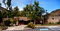 |
May 28, 1987 (#87001452) |
Bandelier National Monument 35°46′46″N 106°16′13″W / 35.77942°N 106.270287°W | Los Alamos and Sandoval | Civilian Conservation Corps buildings and infrastructure |
| 4 | Barrio De Analco Historic District |  |
October 18, 1968 (#68000032) |
Santa Fe 35°41′00″N 105°56′11″W / 35.683333°N 105.936389°W | Santa Fe | Historic district including the oldest house in the state of New Mexico, and the oldest Catholic church in the continental United States
(Oldest Churches, Annexed Territories vs original founding Colony States).[3] |
| 5 | Big Bead Mesa | July 19, 1964 (#66000958) |
Casa Salazar | Sandoval | Fortified Navajo village site; served as a base for trade and raiding from 1745 to 1812 | |
| 6 | Blackwater Draw |  |
January 20, 1961 (#66000483) |
Clovis 34°16′40″N 103°19′28″W / 34.277874°N 103.32458°W | Roosevelt | Archaeological type site of the Clovis culture |
| 7 | Ernest L. Blumenschein House |  |
December 21, 1965 (#66000495) |
Taos 36°24′21″N 105°34′37″W / 36.405954°N 105.576890°W | Taos | Home of painter Ernest L. Blumenschein, co-founder of Taos Art Colony |
| 8 | Carlsbad Irrigation District | 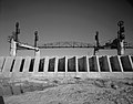 |
July 19, 1964 (#66000476) |
Carlsbad 32°29′27″N 104°15′08″W / 32.490796°N 104.252119°W | Eddy | Early 20th-century water reclamation project |
| 9 | Kit Carson House |  |
May 23, 1963 (#66000948) |
Taos 36°24′19″N 105°34′20″W / 36.405159°N 105.572131°W | Taos | Home of frontiersman Kit Carson |
| 10 | Denver & Rio Grande Railroad San Juan Extension (Cumbres & Toltec Scenic Railroad) |  |
October 16, 2012 (#73000462) |
Antonito, CO and Chama, NM 36°59′04″N 106°18′20″W / 36.98442°N 106.305563°W | Archuleta, CO, Conejos, CO, and Rio Arriba, NM | Longest and most complete representation of late nineteenth- and early twentieth-century railroading. |
| 11 | El Santuario de Chimayó |  |
April 15, 1970 (#70000412) |
Chimayo 35°59′21″N 105°55′54″W / 35.989167°N 105.931667°W | Santa Fe | Roman Catholic church, famous for the story of its founding and as a contemporary pilgrimage site |
| 12 | Folsom site |  |
January 20, 1961 (#66000473) |
Folsom 36°52′54″N 104°04′16″W / 36.88169°N 104.07108°W | Colfax | Archaeological site; type site for the Folsom tradition |
| 13 | Fort Bayard Site |  |
March 19, 2004 (#02000726) |
Santa Clara 32°47′47″N 108°08′56″W / 32.796389°N 108.148889°W | Grant | Site of an 1866 post of Buffalo Soldiers |
| 14 | Glorieta Pass Battlefield |  |
November 5, 1961 (#66000486) |
Pecos 35°33′36″N 105°47′08″W / 35.56°N 105.785556°W | Santa Fe | Site of American Civil War Battle of Glorieta Pass |
| 15 | Hawikuh |  |
October 9, 1960 (#66000502) |
Zuni 34°56′18″N 108°59′57″W / 34.938404°N 108.999155°W | Cibola | Largest of the Zuni pueblos; founded in the 13th century |
| 16 | Las Trampas Historic District |  |
May 28, 1967 (#67000007) |
Las Trampas 36°07′51″N 105°45′48″W / 36.130701°N 105.763285°W | Taos | Founded in 1751 by twelve Spanish families from Santa Fe; known for the church of San José de Gracia |
| 17 | Lincoln Historic District |  |
December 19, 1960 (#66000477) |
Lincoln 33°29′41″N 105°22′56″W / 33.494722°N 105.382222°W | Lincoln | Well-preserved cow town, Ground Zero for Lincoln County War! The Lincoln County Jail (former Murphy Store) where Billy the Kid made his final escape, killing (HELLO BOB!) deputy Bob Olinger & James bell. A must see! |
| 18 | Los Alamos Scientific Laboratory |  |
December 21, 1965 (#66000893) |
Los Alamos 35°52′32″N 106°19′27″W / 35.875556°N 106.324167°W | Los Alamos | United States Department of Energy (DOE) national laboratory; major site of the Manhattan Project |
| 19 | Mabel Dodge Luhan House |  |
December 4, 1991 (#78001832) |
Taos 36°24′29″N 105°33′52″W / 36.408056°N 105.564444°W | Taos | Artists' haven of Mabel Dodge Luhan, now an inn |
| 20 | Manuelito Complex | July 19, 1964 (#66000894) |
Manuelito | McKinley | Major post-Chaco culture sites | |
| 21 | Mesilla Plaza |  |
July 4, 1961 (#82003323) |
Mesilla 32°16′28″N 106°47′44″W / 32.274311°N 106.795462°W | Doña Ana | Town center historically associated with US acquisition of New Mexico |
| 22 | National Park Service Region III Office | 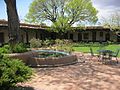 |
May 28, 1987 (#70000067) |
Santa Fe 35°39′54″N 105°55′21″W / 35.665134°N 105.922622°W | Santa Fe | Masterpiece of Spanish/Pueblo revival architecture |
| 23 | Georgia O'Keeffe Home and Studio |  |
August 5, 1998 (#98001197) |
Abiquiu 36°12′22″N 106°19′01″W / 36.206172°N 106.316872°W | Rio Arriba | Home and studio of artist Georgia O'Keeffe |
| 24 | Palace of the Governors |  |
October 9, 1960 (#66000489) |
Santa Fe 35°41′09″N 105°56′15″W / 35.685936°N 105.937504°W | Santa Fe | Adobe structure; construction began in 1610; served as the seat of government in New Mexico for centuries; oldest continuously occupied public building in the United States |
| 25 | Pecos Pueblo |  |
October 9, 1960 (#66000485) |
Pecos 35°33′00″N 105°41′22″W / 35.549905°N 105.68939°W | San Miguel | Large pueblo abandoned in 19th century; in Pecos National Historical Park |
| 26 | Puye Ruins |  |
May 23, 1966 (#66000481) |
Espanola 35°58′32″N 106°13′39″W / 35.975556°N 106.2275°W | Rio Arriba and Sandoval | Ancestral Puebloan cliff dwellings |
| 27 | Ernie Pyle House |  |
September 20, 2006 (#97001103) |
Albuquerque 35°04′13″N 106°36′45″W / 35.070156°N 106.612581°W | Bernalillo | Former home of famed war correspondent Ernie Pyle |
| 28 | Quarai | 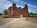 |
June 13, 1962 (#66000498) |
Manzano 34°35′45″N 106°17′42″W / 34.595833°N 106.295°W | Torrance | Pueblo and Spanish mission ruins; part of Salinas Pueblo Missions National Monument |
| 29 | Rabbit Ears |  |
May 23, 1963 (#66000499) |
Clayton 36°35′32″N 103°13′28″W / 36.592222°N 103.224444°W | Union | Twin mountain peaks that were landmarks to wagon trains on Santa Fe Trail |
| 30 | Ratón Pass |  |
December 19, 1960 (#66000474) |
Raton, NM and Trinidad, CO 36°59′28″N 104°29′12″W / 36.991134°N 104.486654°W | Colfax | Mountain pass on the Santa Fe Trail along the Colorado-New Mexico border. Extends into Las Animas County, Colorado. |
| 31 | San Estevan del Rey Mission Church |  |
April 15, 1970 (#70000417) |
Acoma 34°53′42″N 107°34′57″W / 34.895068°N 107.582476°W | Cibola | Church founded in 1629 |
| 32 | San Francisco de Asís Mission Church |  |
April 15, 1970 (#70000416) |
Ranchos de Taos 36°21′31″N 105°36′28″W / 36.3586°N 105.6078°W | Taos | Mission church on Ranchos de Taos Plaza |
| 33 | San Gabriel de Yungue-Ouinge |  |
July 19, 1964 (#66000482) |
Ohkay Owingeh 36°03′26″N 106°05′01″W / 36.057306°N 106.083593°W | Rio Arriba | Site of the first Spanish capital of New Mexico |
| 34 | San José de Gracia Church | |
April 15, 1970 (#70000415) |
Las Trampas 36°07′53″N 105°45′28″W / 36.131389°N 105.757778°W | Taos | Built between 1760 and 1776; model of the adobe architecture; once used by Los Hermanos Penitentes |
| 35 | San José de los Jémez Mission and Gíusewa Pueblo Site |  |
October 16, 2012 (#73001147) |
Jemez Springs 35°46′42″N 106°41′11″W / 35.778445°N 106.686498°W | Sandoval | |
| 36 | San Lazaro | July 19, 1964 (#66000490) |
Santa Fe | Santa Fe | ||
| 37 | Sandia Cave |  |
January 20, 1961 (#66000487) |
Bernalillo 35°15′08″N 106°24′27″W / 35.252221°N 106.407583°W | Sandoval | Cave in which prehistoric artifacts were found and excavated in the 1930s. Accessible via a USFS hiking trail. |
| 38 | Santa Fe Plaza |  |
December 19, 1960 (#66000491) |
Santa Fe 35°41′07″N 105°56′15″W / 35.685396°N 105.937498°W | Santa Fe | Central park lined with grass, trees, and benches; Indian War Memorial monument; performing arts stage |
| 39 | Seton Village |  |
December 21, 1965 (#66000492) |
Santa Fe 35°35′56″N 105°55′54″W / 35.598889°N 105.931667°W | Santa Fe | |
| 40 | Taos Pueblo |  |
October 9, 1960 (#66000496) |
Taos 36°26′21″N 105°32′44″W / 36.43917°N 105.54559°W | Taos | This ancient pueblo belongs to a Northern Tiwa speaking Native American tribe of Pueblo people. Being approximately 1000 years old, it is believed to be the oldest continuously inhabited building in North America. It is a multi-storied residential complex of reddish-brown adobe divided into two parts by the Rio Pueblo de Taos. |
| 41 | Trinity Site | 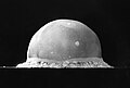 |
December 21, 1965 (#66000493) |
Bingham 33°40′38″N 106°28′31″W / 33.6773°N 106.4754°W | Socorro | Site of the first nuclear weapon detonation. |
| 42 | Village of Columbus and Camp Furlong |  |
May 15, 1975 (#75001164) |
Columbus 31°49′39″N 107°37′50″W / 31.8275°N 107.630556°W | Luna | Site of March 9, 1916 raid by Pancho Villa that had wide impacts |
| 43 | Wagon Mound |  |
May 23, 1963 (#66000478) |
Wagon Mound 36°00′01″N 104°41′41″W / 36.000278°N 104.694722°W | Mora | Landmark on the Santa Fe Trail |
| 44 | Watrous (La Junta) |  |
May 23, 1963 (#66000480) |
Watrous 35°48′03″N 105°00′05″W / 35.800833°N 105.001389°W | Mora | Mountain and Cimarron Cutoff routes of Santa Fe Trail joined here |
| 45 | White Sands V-2 Launching Site | 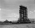 |
October 3, 1985 (#85003541) |
White Sands Missile Range 32°23′58″N 106°22′40″W / 32.399378°N 106.377814°W | Doña Ana | |
| 46 | Zuni-Cibola Complex | December 2, 1974 (#74002267) |
Zuni Pueblo 34°56′17″N 108°59′56″W / 34.938°N 108.999°W | Cibola and McKinley | Complex of prehistoric and historic archaeological sites on Zuni Reservation |
Historic areas of the NPS in New Mexico edit
National Historical Parks, some National Monuments, and certain other areas listed in the National Park system are historic landmarks of national importance that are highly protected already, often before the inauguration of the NHL program in 1960, and are then often not also named NHLs per se. There are nine of these in New Mexico. The National Park Service lists these fourteen together with the NHLs in the state.[4]
| Landmark name |
Image | Date established[5] | Location | County | Description | |
|---|---|---|---|---|---|---|
| 1 | Aztec Ruins National Monument | 
|
January 24, 1923 | Aztec | San Juan | Preserves ancestral Pueblo structures in north-western New Mexico |
| 2 | Bandelier National Monument | 
|
February 11, 1916 | Santa Fe | Sandoval and Los Alamos | Includes Frijoles Canyon; contains (restored) ruins of dwellings, kivas, rock paintings and petroglyphs |
| 3 | Chaco Culture National Historical Park | 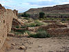
|
March 11, 1907 | Farmington | San Juan and McKinley | Densest and most exceptional concentration of pueblos in the American Southwest |
| 4 | El Morro National Monument | 
|
December 8, 1906 | Ramah | Cibola | Sandstone promontory with a pool of water at its base; shaded oasis in the western U.S. deser; Zuni Indians call it "A'ts'ina" (Place of writings on the rock); Anglo-Americans called it "Inscription Rock"; travelers left signatures, names, dates, and stories of their treks |
| 5 | Fort Union National Monument | 
|
April 5, 1956 | Las Vegas, NM | Mora | Preserves the second of three forts constructed on the site beginning in 1851; also ruins of the third; visible network of ruts from the old Santa Fe Trail |
| 6 | Gila Cliff Dwellings National Monument | 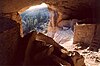
|
November 16, 1907 | Silver City | Catron | Cliff dwellings from the 1280s through the early 1300s |
| 7 | Pecos National Historical Park | 
|
June 28, 1965 | Santa Fe | Santa Fe and San Miguel | Includes parts of Glorieta Pass Battlefield, an NHL, as well as a mission and other areas. |
| 8 | Petroglyph National Monument | 
|
June 27, 1990 | Albuquerque | Bernalillo | Variety of cultural and natural resources including five volcanic cones, hundreds of archeological sites and an estimated 25,000 images carved by native peoples and early Spanish settlers |
| 9 | Salinas Pueblo Missions National Monument | 
|
November 1, 1909 | Albuquerque | Torrance and Socorro | Reminders of this earliest contact between Pueblo Indians and Spanish Colonials: the ruins of four mission churches and the partially excavated pueblo of Las Humanas |
See also edit
References edit
- ^ Numbers represent an alphabetical ordering by significant words. Various colorings, defined here, differentiate National Historic Landmarks and historic districts from other NRHP buildings, structures, sites or objects.
- ^ The eight-digit number below each date is the number assigned to each location in the National Register Information System database, which can be viewed by clicking the number.
- ^ List of the oldest churches in the United States
- ^ These are listed on p.114 of "National Historic Landmarks Survey: List of National Historic Landmarks by State", November 2007 version.
- ^ Date of listing as National Historic Site or similar designation, from various sources in articles indexed.
External links edit
"National Register Information System". National Register of Historic Places. National Park Service. July 9, 2010.