
KNOWPIA
WELCOME TO KNOWPIA

List of National Natural Landmarks in Puerto Rico 
Summary
From List of National Natural Landmarks, these are the National Natural Landmarks in Puerto Rico. There are 5 in total.[1]
| Name | Image | Date | Location | Municipality | Ownership | Description | |
|---|---|---|---|---|---|---|---|
| 1 | Baño de Oro Natural Area | 
|
1980 | 18°18′29″N 65°45′42″W / 18.3080090°N 65.7615515°W | Río Grande | Federal (United States Forest Service) | The only contiguous area in Puerto Rico that contains subtropical wet forest, rain forest, dwarf forest, and Pterocarpus. Part of El Yunque National Forest. |
| 2 | Cabo Rojo | 
|
1980 | 17°56′01.2″N 67°11′31.9″W / 17.933667°N 67.192194°W | Cabo Rojo | Territorial (Puerto Rico Department of Natural and Environmental Resources) | An excellent example of a tombolo with two sand spits. |
| 3 | Mona and Monito Islands | 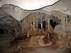
|
1975 | 18°5′5.2″N 67°51′4.4″W / 18.084778°N 67.851222°W | Mayagüez | Territorial (Puerto Rico Department of Natural and Environmental Resources) | Caves on these islands are some of the most extensive flank margin caves in the world. |
| 4 | Puerto Mosquito | 
|
1980 | 18°06′07″N 65°26′45″W / 18.10194°N 65.44583°W | Vieques | Territorial (Puerto Rico Department of Natural and Environmental Resources) | Considered the best example of a bioluminescent bay in the United States. |
| 5 | Río Abajo State Forest | 
|
1980 | 18°20′23″N 66°41′59″W / 18.33972°N 66.69972°W | Utuado | Territorial (Puerto Rico Department of Natural and Environmental Resources) | An excellent example of karst topography with numerous sinkholes and well-developed tower karst. |
See also edit
References edit
- ^ "National Registry of Natural Landmarks". National Park Service.