
KNOWPIA
WELCOME TO KNOWPIA

List of National Natural Landmarks in South Carolina 
Summary
There are six National Natural Landmarks in the U.S. state of South Carolina.

Flat Creek Natural Area and 40 Acre Rock
St. Phillips Island
Stevens Creek Natural Area
class=notpageimage|
South Carolina National Natural Landmarks (clickable map)| Name | Image | Date | Location | County | Ownership | Description | |
|---|---|---|---|---|---|---|---|
| 1 | Congaree River Swamp | 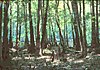
|
May 1974 | Columbia 33°47′N 80°47′W / 33.783°N 80.783°W | Richland | federal | The most extensive, mature cypress-gum swamp and bottomland hardwood forest complex in the State and a sanctuary for wildlife. Part of Congaree National Park.[1] |
| 2 | Flat Creek Natural Area and 40 Acre Rock | 
|
August 1984 | Kershaw 34°40′8″N 80°31′38″W / 34.66889°N 80.52722°W | Lancaster | state | Contains the largest remaining undisturbed granitic flat-rock outcrop in the Carolina Piedmont. Flat-rock vegetation is in good condition, including 13 rare or endemic species and 20 other species characteristic of these outcrops. Flat Creek Dike is one of the thickest in eastern North America at 1,123 ft (342 m). Part of 40 Acre Rock Heritage Preserve.[2] |
| 3 | Francis Beidler Forest | 
|
March 1979 | Harleyville 33°14′N 80°21′W / 33.233°N 80.350°W | Berkeley & Dorchester | private | One of the last large virgin stands of bald cypress-tupelo gum swamp in the United States, with five major community types providing for a rich diversity of species.[3] |
| 4 | John de la Howe Forest | 
|
January 1976 | McCormick 33°56′N 82°24′W / 33.933°N 82.400°W | McCormick | state | An old-growth stand of oak-pine forest protected against fire and timbering since 1797, and one of the best remaining examples of this type of forest in the Piedmont.[4] |
| 5 | St. Phillips Island | 
|
May 1986 | Beaufort 32°17′N 80°37′W / 32.283°N 80.617°W | Beaufort | private | This barrier island is approximately 4 miles (6.4 km) in length and 2 miles (3.2 km) wide. It is unique among the barrier islands of Georgia, South Carolina and northern Florida, because it exists in a nearly undisturbed state with minimal development and past consumptive use; it is also unique to the entire Atlantic Coast for the pronounced multiple vegetated beach dune ridges found here.[5] |
| 6 | Stevens Creek Natural Area | 
|
March 1979 | Plum Branch 33°50′39″N 82°13′27″W / 33.84417°N 82.22417°W | McCormick | state | Pleistocene relict ecosystem harboring flora considered unusual for its combination of plants in this southern location due to unique microenvironmental conditions. Part of Stevens Creek Heritage Preserve.[6] |
See also edit
References edit
- ^ Congaree River Swamp, National Park Service, retrieved 2009-08-08
- ^ Flat Creek Natural Area and 40 Acre Rock, National Park Service, retrieved 2009-08-08
- ^ Francis Beidler Forest, National Park Service, retrieved 2009-08-08
- ^ John de la Howe Forest, National Park Service, retrieved 2009-08-08
- ^ St. Phillips Island, National Park Service, retrieved 2009-08-08
- ^ Stevens Creek Natural Area, National Park Service, retrieved 2009-08-08