List of North Carolina Scenic Byways

Summary

The North Carolina Scenic Byways consists of roads in the state of North Carolina that travel through areas of scenic, historic, and cultural significance. Launched in March 1990, the scenic byway program has presently 59 designated byways, including three national scenic byways and one all American road, a total of 2,300 miles (3,700 km). The intent of this system is to provide travelers with a safe and interesting alternate route.[1]

North Carolina Scenic Byways
System information
Length2,300 mi[1] (3,700 km)
FormedMarch 1990 (1990-03)
Highway names
InterstatesInterstate X (I-X)
US HighwaysUS Highway X (US X)
StateNorth Carolina Highway X (NC X)
System links
  • Interstate
  • US
  • State
  • Scenic National scenic byways edit
    Region Name Image Description mi km References
    Mountain Blue Ridge Parkway   
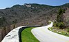
Considered the original scenic byway, the parkway is recognized as an "All American Road" for its spectacular mountain and valley vistas, waterfalls, and colorful flower and foliage displays. Various activities are available along the route and five campgrounds for overnight visitors. The highest point is at Richland-Balsam Gap at 6,053 feet (1,845 m). 242.0 389.5 [2]
    Mountain Cherohala Skyway   Traversing along NC 143, from the Tennessee state line to Santeetlah Gap, in the Nantahala National Forest. The skyway features cultural heritage of the Cherokee tribe and early settlers in a grand forest environment in the Appalachian Mountains. 17.8 28.6 [3]
    Mountain Forest Heritage Scenic Byway   Traversing along US 276, this scenic byway through the Pisgah National Forest features the Cradle of Forestry, waterfalls, trails and scenic vistas. The longer 76.7-mile (123.4 km) National Forest Scenic Byway completes a loop via NC 28 and US 64, connecting Lake Logan and the town of Brevard. 17.6 28.3 [4][5]
    Coastal Plain Outer Banks Scenic Byway   Traversing along US 70 and NC 12, the byway connects from the mainland to the barrier islands, via ferry. Both the Cape Lookout National Seashore and Cape Hatteras National Seashore are along its route, as well as national wildlife refuges, tourist beaches, lighthouses and unique maritime culture and historical sites. 137.8 221.8 [6]

    State scenic byways edit

    Region Name Image Description mi km References
    Mountain Waterfall Byway   Follows Harshaw Road (SR 1558), Brasstown Road (SR 1134), Old US 64 (SR 1100), Settawig Road (SR 1135) and US 64. Named for the 200 waterfalls that surround the route, it passes by notable sites including the Cullasaja Gorge, Highlands, Cashiers and Lake Toxaway.

    Tractor-Trailers are prohibited on this road and it is also not recommended for recreational vehicles or buses.

    98.0 157.7 [7]
    Mountain Nantahala Byway   The byway traverses between Marble and Whittier, along US 19/US 74/US 129. It is known for its scenic views of the Nantahala Gorge, The Great Smoky Mountain Railroad, and the whitewater rafting on the Nantahala River. 43.0 69.2 [7]
    Mountain Indian Lakes Scenic Byway   Follows US 129, from Topton to Deals Gap, where it continues along NC 28 to Almond. The byway provide scenic views along the banks of the Nantahala River, Little Tennessee River, and Cheoah River. It also features the Fontana Dam, Cheoah Dam, Santeetlah Dam, the grave of Junaluska and the Tail of the Dragon.

    This route is not recommended for recreational vehicles or buses.

    60.0 96.6 [7]
    Mountain Whitewater Way     NC 281 9.0 14.5 [7]
    Mountain Appalachian Medley        US 25 / US 70 / NC 209 / NC 213 45.0 72.4 [7]
    Mountain Big Horse Creek Scenic Byway   NC 194 18.0 29.0 [8]
    Mountain French Broad Overview  


      US 25 Bus. / US 70 Bus. / NC 251
    17.0 27.4 [7]
    Mountain Historic Flat Rock Scenic Byway   The byway is located along NC 225, between Pinnacle Mountain Road (SR 1114) and Highland Lake Road (SR 1783), in the Flat Rock area. It is noted for its views of nearby Glassy and McAlpin mountains and access to the Carl Sandburg Home National Historic Site, the Flat Rock Playhouse and the Flat Rock Historic District. 8.3 13.4 [7]
    Mountain Drovers Road   US 74A 16.5 26.6 [7]
    Mountain Black Mountain Rag Follows US 64, from Edneyville to Lake Lure and NC 9, from Bat Cave to Black Mountain. The byway connects Chimney Rock State Park, Hickory Nut Gorge and Lake Lure. It is named after old fiddle tune, the Black Mountain Rag, for it's full of twists, turns, ups and downs.

    This byway is not recommended for recreational vehicles or buses.

    31.0 49.9 [7]
    Mountain Pacolet River Byway     US 176 10.0 16.1 [7]
    Mountain South Mountain Scenery   NC 226 33.0 53.1 [7]
    Mountain Mission Crossing     NC 194 17.0 27.4 [7]
    Mountain Mount Mitchell Scenic Drive   Starting at the I-26 interchange (exit 9), the byway follows US 19 in Madison County and US 19E in Yancey County. In Micaville, it switches onto NC 80 and goes through the Toe River valley. Connecting at the Blue Ridge Parkway, travelers continue south until reaching NC 128, where it makes its final ascent to the top of Mount Mitchell. The byway features mountain scenic vistas and local culture experience in Celo and Burnsville. 52.0 83.7 [7][9]
    Mountain Little Parkway     US 221 18.0 29.0 [7]
    Mountain New River Valley Byway      NC 88 / NC 194 35.0 56.3 [7]
    Mountain I-26 Scenic Highway The byway traverses between Tennessee state line and Exit 9 (US 19/US 23A), near Mars Hill, along I-26/US 23. The byway is known for its unspoiled views of the North Carolina Mountains. 9.0 14.5 [7]
    Mountain U.S. 421 Scenic Byway Follows US 221 and US 421 from the Blue Ridge Parkway, in Deep Gap, to the South Fork New River, near Boone. The byway features panoramic views of Snake Mountain and Elk Knob, as well as the forests, horse/cattle farms, and Fraser Fir Christmas Tree farms. 8.0 12.9 [7]
    Mountain Pisgah Loop Scenic Byway   The loop byway traverses along NC 181, NC 183, Old NC Highway 105 (SR 1238), NC 126 and Fish Hatchery Road (SR 1254/SR 1240). The byway is noted its history as the same route the Kirk's Raiders used to make a successful attack on Confederate Army Camp Vance, outside Morganton, during the Civil War. It is also noted for scenic views of the surrounding mountains and access to various trails along the route.

    This byway is not recommended for recreational vehicles or buses; four-wheel drive is recommended for unpaved portions of the loop.

    47.0 75.6 [7]
    Mountain Smoky Mountain Scenic Byway   The byway is located along US 441 (Newfound Gap Road), between the Blue Ridge Parkway, in Ravensford, and the Tennessee state line, at Newfound Gap. Various overlooks dot along the byway, with unique attractions nearby including Clingmans Dome, Oconaluftee Archaeological District and area trails. 16.5 26.6 [7]
    Mountain Upper Yadkin Way   The byway traverses along NC 268 between US 321 and W.Kerr Scott Reservoir, in an area known as Happy Valley. Near Ferguson is the grave of Tom Dula, remembered in the folk song "Tom Dooley." 25.0 40.2 [7]
    Mountain Yadkin Valley Scenic Byway   The byway connects various vineyards and wineries in the area, starting from downtown Elkin and making a loop along US 21, Swan Creek Road, Old US 421, Rockford Road, Zephyr Road and Springs Road. 65.0 104.6 [7]
    Piedmont McAuley Road Scenic Byway Protected along lands controlled by the Catawba Lands Conservancy, the road provides one of the last vestiges of rural vistas of what once dominated Mecklenburg County till the mid-20th century. 1.5 2.4 [10]
    Piedmont Hanging Rock Scenic Byway    NC 66 / NC 89 38.0 61.2 [7]
    Piedmont Clayton Bypass Scenic Byway The byway is located along US 70, between I-40 and US 70 Bus. It features rolling hills and open pastures peppered with woodlands. 10.7 17.2 [7]
    Piedmont Colonial Heritage Byway    
     
          US 70 Bus. / NC 57 / NC 62 / NC 86 / NC 150 / NC 751
    92.0 148.1 [7]
    Piedmont Football Road   37.0 59.5 [7]
    Piedmont Crowders Mountain Drive   NC 161 8.0 12.9 [7]
    Piedmont Mill Bridge Scenic Byway     NC 150 14.0 22.5 [7]
    Piedmont Uwharrie Scenic Road     NC 49 50.0 80.5 [7]
    Piedmont Rolling Kansas Byway 9.0 14.5 [7]
    Piedmont Pee Dee Valley Drive       NC 24 / NC 27 / NC 73 14.0 22.5 [7]
    Piedmont Grassy Island Crossing     NC 109 26.0 41.8 [7]
    Piedmont Sandhills Scenic Drive       NC 24 / NC 27 / NC 73 46.0 74.0 [7]
    Piedmont Birkhead Wilderness Route   14.0 22.5 [7]
    Piedmont Flint Hill Ramble   5.0 8.0 [7]
    Piedmont Indian Heritage Trail      US 220 / NC 73 18.0 29.0 [7]
    Piedmont Pottery Road   Located along NC 705, between Eagle Springs and Seagrove. The byway traverses through an area where seven families from Staffordshire, the pottery center of England, settled. Their descendants continue to make both traditional and modern pottery forms and nearly 80 potteries can be found in the vicinity of the byway. 43.0 69.2 [7]
    Piedmont Devil's Stompin' Ground Road     NC 902 43.0 69.2 [7]
    Piedmont North Durham Country Byway   27.0 43.5 [7]
    Piedmont Averasboro Battlefield Scenic Byway     NC 82 4.7 7.6 [7]
    Piedmont Scots-Welsh Heritage Byway   The byway traverses along historic trade roads used by American Indians and early backcountry pioneers. The King of England gave much of the land along this byway to 18th century Scotch-Welsh settlers; much of the land surrounding this byway still used today for farming by those same decedents. Access to the byway is via I-40 at Exit 261 (Hillsborough) and onto Old NC 86. Following south on Old NC 86, cross over New Hope Creek and turn right onto Arthur Minnis Road (SR 1129), continue until Orange Grove Road (SR 1006) and take left, take left onto Dairyland Road (SR 1104), then left again onto Rocky Ridge Road. Once returning to Arthor Minnis Road and left back onto Old NC 86, the byway ends. 10.0 16.1 [7]
    Coastal Plain Blue-Gray Scenic Byway     NC 58 82.0 132.0 [7]
    Coastal Plain Meteor Lakes Byway     NC 242 39.0 62.8 [7]
    Coastal Plain Green Swamp Byway   NC 211 53.0 85.3 [7]
    Coastal Plain Brunswick Town Road   The byway begins at the intersection of NC 133 and Plantation Road (SR 1529), near Southport, and follows Plantation Road to Tryon Palace Road (SR 1533) and follow it to Brunswick Town State Historic Site. This byway showcases historical Brunswick County. 3.0 4.8 [7]
    Coastal Plain Cape Fear Historic Byway   Located in downtown Wilmington, it features scenic urban areas, colonial-era streets, the U.S.S. North Carolina, and the city parks. The following roads and highways that makeup this byway are: US 17, US 17 Bus., US 421, Third Street, Water Street, Front Street, Castle Street, Fifth Street and Lake Shore Drive. 8.0 12.9 [7]
    Coastal Plain Lafayette's Tour           US 13 / US 158 / US 258 / NC 43 / NC 58 / NC 125 / NC 137 / NC 561 / NC 903 173.0 278.4 [7]
    Coastal Plain Tar Heel Trace        NC 42 / NC 124 / NC 125 / NC 142 53.0 85.3 [7]
    Coastal Plain Edenton-Windsor Loop      
     
        US 13 / US 17 / US 13 Bus. / NC 32 / NC 45 / NC 308
    87.0 140.0 [7]
    Coastal Plain Perquimans Crossing    
     
      US 17 Bus. / NC 37
    3.0 4.8 [7]
    Coastal Plain Pamlico Scenic Byway         US 264 / NC 32 / NC 45 / NC 92 / NC 99 127.0 204.4 [7]
    Coastal Plain Alligator River Route   The byway follows NC 94 north, from New Holland to Columbia, where it goes east along US 64 Bus. and US 64 to Manns Harbor and Roanoke Island. The byway features expansive wetlands, open farmlands, Alligator River National Wildlife Refuge and Lake Mattamuskeet. 71.0 114.3 [7]
    Coastal Plain Roanoke Voyages Corridor   The byway follows US 64 through Roanoke Island. It features Fort Raleigh National Historic Site (site of the first English settlement in North America), the North Carolina Aquarium, and Roanoke Island Festival Park. 9.0 14.5 [7]

    Other scenic byways and roads edit

    Region Name Image Description mi km References
    Mountain Lakeview Drive   Also known as the "Road to Nowhere," this Great Smoky Mountains National Park road follows along the north shore of the Tuckasegee River and provides unspoiled views of the Cheoah Mountains and access to various hiking and riding trails. 6.5 10.5
    Mountain Mountain Waters Scenic Byway   This National Forest Scenic Byway traverses through the Nantahala National Forest, along US 64, Old Murphy Road (SR 1442), Wayah Road (SR 1310), US 19/US 74 and NC 28. The byway features two river gorges, hardwood forests and countryside vistas. 64.5 103.8 [11]
    Coastal Plain Historic Albemarle Tour A tour route that encompasses 16 highway in northeastern North Carolina, with signage along routes identifying points of historical interest.

    See also edit

    References edit

    1. ^ a b Morgan, Connie (March 3, 2016). North Carolina Scenic Byway Program - 2015 Annual Report (PDF) (Report). North Carolina Department of Transportation. Retrieved March 23, 2016.
    2. ^ "Blue Ridge Parkway". United States Department of Transportation. Retrieved November 28, 2014.
    3. ^ "Cherohala Skyway". United States Department of Transportation. Retrieved November 28, 2014.
    4. ^ "Forest Heritage National Scenic Byway". United States Department of Transportation. Retrieved November 25, 2014.
    5. ^ "Forest Heritage National Scenic Byway" (PDF). United States Forest Service. October 2001. Retrieved November 25, 2014.
    6. ^ "Outer Banks Scenic Byway". United States Department of Transportation. Retrieved November 28, 2014.
    7. ^ a b c d e f g h i j k l m n o p q r s t u v w x y z aa ab ac ad ae af ag ah ai aj ak al am an ao ap aq ar as at au av aw ax ay az "North Carolina Scenic Byways" (PDF). North Carolina Department of Transportation. Archived from the original (PDF) on October 20, 2012. Retrieved June 28, 2015.
    8. ^ "NCDOT Announces North Carolina's Newest Scenic Byway" (Press release). Raleigh: North Carolina Department of Transportation. April 8, 2016. Retrieved April 18, 2016.
    9. ^ "Mt. Mitchell Scenic Drive Recognized as Scenic NC Byway". Blue Ridge National Heritage Area. November 3, 2011. Retrieved March 22, 2016.
    10. ^ "North Carolina Byways". North Carolina Department of Transportation. Retrieved February 7, 2024.
    11. ^ "Mountain Waters Scenic Byway" (PDF). United States Forest Service. May 2008. Retrieved November 26, 2014.

    External links edit

    •   Media related to North Carolina Scenic Byways at Wikimedia Commons
    • NCDOT: Scenic Byways
    • NSBP: North Carolina