
KNOWPIA
WELCOME TO KNOWPIA

List of Ramsar sites in the United States 
Summary
This list of Ramsar sites in the United States are those wetlands that are considered to be of international importance, protected under the Ramsar Convention. The United States as of 2020, has 41 sites designated as "Wetlands of International Importance" with a surface area of 1,884,551 hectares (7,276.29 sq mi; 18,845.51 km2).[1][2] For a full list of all Ramsar sites worldwide, see List of Ramsar wetlands of international importance.
List of Ramsar sites edit
| Name[2] | Location | Area[2] | Designated | Description | Image |
|---|---|---|---|---|---|
| Ash Meadows National Wildlife Refuge | Nevada 36°25′N 116°20′W / 36.417°N 116.333°W |
36.71 sq mi | 18 December 1986 | 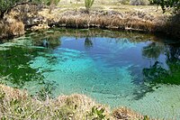
| |
| Bolinas Lagoon | California 37°55′N 122°41′W / 37.917°N 122.683°W |
1.72 sq mi | 1 September 1998 | A tidal estuary located on the Pacific Flyway, the lagoon provides habitat for migratory birds as well as ducks, geese, and shorebirds. | 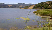
|
| Cache-Lower White Rivers | Arkansas 34°40′N 91°11′W / 34.667°N 91.183°W |
314.19 sq mi | 21 November 1989 | 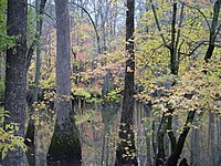
| |
| Cache River-Cypress Creek Wetlands | Illinois 37°13′N 89°8′W / 37.217°N 89.133°W |
93.75 sq mi | 1 November 1994 | 
| |
| Caddo Lake | Texas, Louisiana 32°45′N 94°8′W / 32.750°N 94.133°W |
30.80 sq mi | 23 October 1993 | 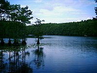
| |
| Catahoula Lake | Louisiana 31°30′N 92°6′W / 31.500°N 92.100°W |
46.9 sq mi | 18 June 1991 | ||
| Chesapeake Bay Estuarine Complex | Maryland, Virginia 38°0′N 76°20′W / 38.000°N 76.333°W |
170 sq mi | 4 June 1987 | 
| |
| Cheyenne Bottoms | Kansas 38°29′N 98°40′W / 38.483°N 98.667°W |
42.39 sq mi | 19 October 1988 | 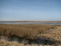
| |
| Chiwaukee Illinois Beach Lake Plain | Illinois Wisconsin 42°25′02″N 87°48′42″W / 42.41722°N 87.81167°W |
6.12 sq mi | 6 October 2015 | Bi-state, lake-coast lands, including Chiwaukee Prairie and Illinois Beach State Park | 
|
| Congaree National Park | South Carolina 33°47′22″N 80°45′34″W / 33.78944°N 80.75944°W |
40.69 sq mi | 2 February 2012 | 
| |
| Connecticut River Estuary and Tidal Wetlands Complex | Connecticut 41°15′N 72°18′W / 41.250°N 72.300°W |
25.03 sq mi | 14 October 1994 | 
| |
| Corkscrew Swamp Sanctuary | Florida 26°24′N 81°31′W / 26.400°N 81.517°W |
20.31 sq mi | 23 March 2009 | 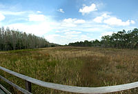
| |
| Delaware Bay Estuary | Delaware, New Jersey 39°11′N 75°14′W / 39.183°N 75.233°W |
197.89 sq mi | 20 May 1992 | 
| |
| Door Peninsula Coastal Wetlands | Wisconsin 45°13′20″N 85°00′00″W / 45.22222°N 85.00000°W |
17.880 sq mi | 6 October 2014 | ||
| Edwin B. Forsythe National Wildlife Refuge | New Jersey 39°36′N 74°17′W / 39.600°N 74.283°W |
50.5 sq mi | 18 December 1986 | 
| |
| Elkhorn Slough | California 36°49′33″N 121°45′25″W / 36.8259°N 121.7569°W |
2.80 sq mi | 25 June 2018 | 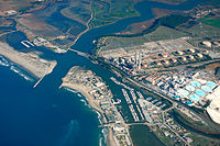
| |
| Everglades National Park | Florida 25°33′N 80°55′W / 25.550°N 80.917°W |
2,357.14 sq mi | 4 June 1987 | 
| |
| Francis Beidler Forest | South Carolina 33°15′N 80°22′W / 33.250°N 80.367°W |
24.86 sq mi | 30 May 2008 | 
| |
| Grassland Ecological Area | California 37°10′N 120°50′W / 37.167°N 120.833°W |
250 sq mi | 2 February 2005 | ||
| Horicon Marsh | Wisconsin 43°30′N 88°38′W / 43.500°N 88.633°W |
49.85 sq mi | 4 December 1990 | 
| |
| Humbug Marsh | Michigan 42°6′N 83°11′W / 42.100°N 83.183°W |
0.73 sq mi | 20 January 2010 | ||
| Izembek Lagoon National Wildlife Refuge | Alaska 55°45′N 162°41′W / 55.750°N 162.683°W |
650.32 sq mi | 18 December 1986 | 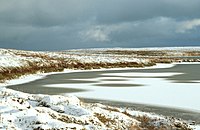
| |
| Kakagon and Bad River Sloughs | Wisconsin 46°39′N 90°41′W / 46.650°N 90.683°W |
16.81 sq mi | 2 February 2012 | 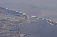
| |
| Kawainui and Hamakua Marsh Complex | Hawaii 21°24′N 157°45′W / 21.400°N 157.750°W |
1.60 sq mi | 2 February 2005 | 
| |
| Laguna de Santa Rosa Wetland Complex | California 38°24′N 122°47′W / 38.400°N 122.783°W |
6.08 sq mi | 16 April 2010 | 
| |
| Lower Wisconsin Riverway | Wisconsin 43°09′N 90°21′W / 43.150°N 90.350°W |
68 sq mi | 14 February 2020 | ||
| Niagara River Corridor | New York 43°5′N 79°4′W / 43.083°N 79.067°W |
20.261 sq mi | 3 October 2019 | 
| |
| Okefenokee National Wildlife Refuge | Georgia, Florida 30°48′N 82°20′W / 30.800°N 82.333°W |
627.94 sq mi | 18 December 1986 | 
| |
| Palmyra Atoll National Wildlife Refuge | Line Islands 5°52′N 162°6′W / 5.867°N 162.100°W |
788.14 sq mi | 1 April 2011 | 
| |
| Pelican Island National Wildlife Refuge | Florida 27°48′N 80°25′W / 27.800°N 80.417°W |
7.37 sq mi | 14 March 1993 | 
| |
| Quivira National Wildlife Refuge | Kansas 38°5′N 98°29′W / 38.083°N 98.483°W |
34.59 sq mi | 12 February 2002 | The refuge has 34 wetlands and includes two shallow lakes, Big Salt Marsh and Little Salt Marsh. More than half of the refuge is Tallgrass and Shortgrass prairies. | 
|
| Roswell Artesian Wetlands | New Mexico 33°27′N 104°23′W / 33.450°N 104.383°W |
3.54 sq mi | 7 September 2010 | 
| |
| San Francisco Bay and Estuary | California 37°52′N 122°23′W / 37.867°N 122.383°W |
612.79 sq mi | 2 February 2013 | 
| |
| Sand Lake National Wildlife Refuge | South Dakota 45°45′N 98°15′W / 45.750°N 98.250°W |
34 sq mi | 3 August 1998 | 
| |
| Sue and Wes Dixon Waterfowl Refuge at Hennepin and Hopper Lake | Illinois 41°13′20″N 89°20′17″W / 41.22222°N 89.33806°W |
4.31 sq mi | 2 February 2012 | 
| |
| The Emiquon Complex | Illinois 40°21′22″N 90°3′10″W / 40.35611°N 90.05278°W |
22.12 sq mi | 2 February 2012 | 
| |
| Tijuana River National Estuarine Research Reserve | California 32°33′N 117°7′W / 32.550°N 117.117°W |
3.94 sq mi | 2 February 2005 | 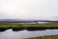
| |
| Tomales Bay | California 38°9′N 123°23′W / 38.150°N 123.383°W |
28.5 km2 (11.0 sq mi) | 30 September 2002 | 
| |
| Upper Mississippi River Floodplain Wetlands | Minnesota, Wisconsin, Iowa, Illinois 43°3′N 91°10′W / 43.050°N 91.167°W |
472.42 sq mi | 5 January 2010 | 
| |
| Wilma H. Schiermeier Olentangy River Wetland Research Park | Ohio 40°1′N 83°1′W / 40.017°N 83.017°W |
0.081 sq mi | 18 April 2008 | 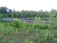
|
See also edit
References edit
External links edit
 Media related to Ramsar sites in the United States at Wikimedia Commons