


Summary
The United Nations Educational, Scientific and Cultural Organization (UNESCO) World Heritage Sites are places of importance to cultural or natural heritage as described in the UNESCO World Heritage Convention, established in 1972.[1] Chile accepted the convention on 20 February 1980 and currently has 6 sites listed. As of 2014[update], an additional 17 properties have been placed on the tentative list for possible future inclusion on the World Heritage List: 15 cultural sites and two natural sites.[2] Chile had its first site included on the list at the 19th session of World Heritage Committee, held in Germany, 1995. At that session, the Rapa Nui National Park was inscribed on the list.


World Heritage Sites edit
- Name: as listed by the World Heritage Committee
- Location: Region and Province where the site is located. If the site is a trans-border site the other countries will be listed in a note.
- Coordinates: geographic coordinates of the site's location
- Date of Inscription: Year and session the site was added to the World Heritage List
- Criteria: The criteria it was listed under: criteria (i) through (vi) are cultural, while (vii) through (x) are natural
- Description: brief description of the site as listed by the World Heritage Committee
- ID: Reference number given by UNESCO
- ‡ Trans-border site
- † In danger
| Name | Image | Location | Date of Inscription | Criteria | ID | Description |
|---|---|---|---|---|---|---|
| Rapa Nui National Park | 
|
Easter Island 27°05′S 109°16′W / 27.09°S 109.27°W |
1995 (19th session) |
Cultural (i), (iii), (v) |
715 | "Rapa Nui, the indigenous name of Easter Island, bears witness to a unique cultural phenomenon. A society of Polynesian origin that settled there c. A.D. 300 established a powerful, imaginative and original tradition of monumental sculpture and architecture, free from any external influence. From the 10th to the 16th century this society built shrines and erected enormous stone figures known as moai , which created an unrivalled cultural landscape that continues to fascinate people throughout the world."[3] |
| Churches of Chiloé | 
|
42°18′S 73°28′W / 42.30°S 73.46°W |
2000 (24th session) |
Cultural (ii) (iii) |
971 | "The Churches of Chiloé represent a unique example in Latin America of an outstanding form of ecclesiastical wooden architecture. They represent a tradition initiated by the Jesuit Peripatetic Mission in the 17th and 18th centuries, continued and enriched by the Franciscans during the 19th century and still prevailing today. These churches embody the intangible richness of the Chiloé Archipelago, and bear witness to a successful fusion of indigenous and European culture, the full integration of its architecture in the landscape and environment, as well as to the spiritual values of the communities."[4] |
| Historic Quarter of the Seaport City of Valparaíso | 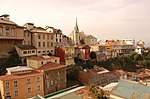
|
33°02′S 71°37′W / 33.04°S 71.61°W |
2003 (27th session) |
Cultural (iii) |
959 | "The colonial city of Valparaíso presents an excellent example of late 19th-century urban and architectural development in Latin America. In its natural amphitheatre-like setting, the city is characterized by a vernacular urban fabric adapted to the hillsides that are dotted with a great variety of church spires. It contrasts with the geometrical layout utilized in the plain. The city has well preserved its interesting early industrial infrastructures, such as the numerous ‘elevators’ on the steep hillsides."[5] |
| Humberstone and Santa Laura Saltpeter Works | 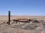
|
20°07′S 69°28′W / 20.12°S 69.47°W |
2005 (29th session) |
Cultural (ii), (iii), (iv) |
1178 | "Humberstone and Santa Laura works contain over 200 former saltpeter works where workers from Chile, Peru and Bolivia lived in company towns and forged a distinctive communal pampinos culture. That culture is manifest in their rich language, creativity, and solidarity, and, above all, in their pioneering struggle for social justice, which had a profound impact on social history. Situated in the remote Pampas, one of the driest deserts on Earth, thousands of pampinos lived and worked in this hostile environment for over 60 years, from 1880, to process the largest deposit of saltpeter in the world, producing the fertilizer sodium nitrate that was to transform agricultural lands in North and South America, and in Europe, and produce great wealth for Chile. Because of the vulnerability of the structures and the impact of a recent earthquake, the site was also placed on the List of World Heritage in Danger to help mobilize resources for its conservation." In 2019, the site was removed from the List of World Heritage in Danger.[6][7] |
| Sewell Mining Town | 
|
34°03′S 70°13′W / 34.05°S 70.22°W |
2006 (30th session) |
Cultural (ii) |
1214 | "Situated at 2,000 m in the Andes, 60 km to the east of Rancagua, in an environment marked by extremes of climate, Sewell Mining Town was built by the Braden Copper company in 1905 to house workers at what was to become the world’s largest underground copper mine, El Teniente. It is an outstanding example of the company towns that were born in many remote parts of the world from the fusion of local labour and resources from an industrialized nation, to mine and process high-value natural resources. The town was built on a terrain too steep for wheeled vehicles around a large central staircase rising from the railway station. Along its route formal squares of irregular shape with ornamental trees and plants constituted the main public spaces or squares of the town. The buildings lining the streets are timber, often painted in vivid green, yellow, red and blue. At its peak Sewell numbered 15,000 inhabitants, but was largely abandoned in the 1970s."[8] |
| Qhapaq Ñan, Andean Road System‡ | 
|
2014 (38th session) |
Cultural (ii)(iii)(iv)(vi) |
1459 | "This site is an extensive Inca communication, trade and defence network of roads covering 30,000 km. Constructed by the Incas over several centuries and partly based on pre-Inca infrastructure, this extraordinary network through one of the world’s most extreme geographical terrains linked the snow-capped peaks of the Andes – at an altitude of more than 6,000 m – to the coast, running through hot rainforests, fertile valleys and absolute deserts. It reached its maximum expansion in the 15th century, when it spread across the length and breadth of the Andes. The Qhapac Ñan, Andean Road System includes 273 component sites spread over more than 6,000 km that were selected to highlight the social, political, architectural and engineering achievements of the network, along with its associated infrastructure for trade, accommodation and storage, as well as sites of religious significance."[9] | |
| Archaeological sites of the Chinchorro culture | 
|
18°17′S 70°11′W / 18.28°S 70.19°W 23°24′S 70°15′W / 23.40°S 70.25°W 19°03′S 70°02′W / 19.05°S 70.04°W |
2021 (44th session) |
Cultural (iii)(v) |
1634 | "Towards the year 7000 B.C., at the north end of Chile, some groups of hunters from the Andes start to approach the coast and to make use of the resources offered by the Pacific Ocean, probably motivated by the climatic changes befallen after the last glaciations. In this period, called Archaic, the hunters began to exploit such coastal environments gradually adapting their tools. Thus, the first fishing societies of the region were born, using a fishing technology based on the ~shell hook", which was carved out of the shell of the choro zapato -mytilus- the colors of which attract the attention of the hunter fishes. These groups populated, between 6.000 and 2.000 B.C., the desert-like pampa stretching out to the sea and covering from the south of Peru (110) to the region of Antofagasta in Chile. The best testimonies of this development are found at the mouth of the Camarones River. The Chinchorro groups kept on hunting in nearby places and exploiting its resources, but since their main nourishment came from the sea, they settled at the coast, living in houses built over circular hollows dig in the soil to which wind-shields were attached. Near their houses, they deposited their wastes, specially shells, and buried many of their dead, whose bodies they wished to preserved. Thus, 3000 years before Egypt, they developed a mummification technique, creating a tradition lasting about 4000 years and which has been named Chinchorro."[10] |
Tentative List edit
In addition to the sites inscribed on the World Heritage list, member states can maintain a list of tentative sites that they may consider for nomination. Nominations for the World Heritage list are only accepted if the site was previously listed on the tentative list.[11] As of 2017, Chile recorded 17 sites on its tentative list.[12]
- Name: as listed by the World Heritage Committee
- Location: Regions and Province where is located and geographic coordinates of the site
- Date of submission: Date the site was submitted to the Tentative List
- Criteria: The criteria it was listed under: criteria (i) through (vi) are cultural, while (vii) through (x) are natural
- Description: brief description of the site
- ID: Reference number given by UNESCO
| Name | Image | Location | Date of Submission | Criteria | ID | Description |
|---|---|---|---|---|---|---|
| Ayquina and Toconce | 
|
22°09′S 68°05′W / 22.15°S 68.09°W 22°10′S 68°11′W / 22.16°S 68.19°W |
1 September 1998 | Cultural (ii)(iii)(iv)(v)(vi) |
1192 | "The location of the nominated villages corresponds to an area of traditional Andean settlement characterized by small towns and villages of an economy based on strong ties of reciprocity and exchange. This agricultural-pastoral economy is based on the traditional Camelidae stockbreeding and the growing of a large variety of vegetables in terraces. Ayquina (2,980 meters above sea level) is a village of agglutinated pattern, built at a dry ravine on the northwestern slope of the Salado River Canyon, over a wall of rock 40 to 50 meters high. Its layout consists in a central axis formed by the church-square space, located in a depression, with the houses to both sides of this axis arranged in a stair-like manner. With regard to environmental conditions, Ayquina is located at a transition area between the typical desert climate and that of a marginal desert at great heights, which manifests itself in the gradual change of landscape. The small village of Toconce, 3,350 meters above sea level, is the easternmost community of the province next to the Bolivian border. Its surrounding area is characteristic of the desert at great heights. The town is located high up the southern slope of the Toconce River, dominating the Paniri, Leon and Toconce volcanoes."[13] |
| Baquedano Street |
|
20°08′S 70°06′W / 20.13°S 70.10°W |
1 September 1998 | Cultural (ii)(v) |
1189 | "The architecture of Iquique, of which Baquedano Street is an outstanding example, was able of wisely adapting itself to the climatic conditions prevailing in Iquique. This was mainly achieved by means of the use of suitable technologies and architectural and constructive solutions. The buildings on Baquedano Street and, in general, all those which have been built following the traditional architecture of the city, correspond to stores or to houses of immigrants who amassed fortunes thanks to the nitrate works. The buildings are of a sort which can be characterized by three elements: the building material is Oregon pine -which had to be imported from remote areas-, the constructive method is that of simple framework or 'Ballon Frame", and their architectural style is the 4American" or some of its derivatives (Georgian, Greek Revival, Adam). With regard to the patterns characterizing these buildings, we can mention the construction following a continuous frontage (façades), the verticality and lightness of the houses, the organization of spaces around a central nucleus, the presence of the vestibule, the use of the verandah and of skylights or lanterns, the use of watchtowers, and the aerial or shady roof over the terrace roof. The Baquedano Street starts in Prat Square, forming with it an outstanding group of urban and architectural expression which fully symbolizes the nature of the nitrate epic deed. Among this group, there are exceptional monuments such as the Clock Tower, the Building for the Tarapaca's Employees Society, the Municipal Theater and the Astoreca Palace. The first three buildings are located in Prat Square, and the last one in Baquedano Street. Likewise, there are other buildings of great value, such as the Yugoslav Club, the ex Courts of Justice, and the Spanish Social Club."[14] |
| Cerro El Plomo high shrine | 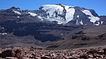
|
33°08′S 70°07′W / 33.13°S 70.12°W |
1 September 1998 | Cultural (ii)(iii)(vi) |
1194 | "On March 30, 1954, a Chilean newspaper announced an archeological discovery of world-wide significance. It was about the frozen body of a child of 8 or 9 years of age, sacrificed by the Incas at the top of one of the highest mountains of the Andes Cordillera, in front of Santiago city. The existence of buildings' traces on the ascending path to the top of this hill was known since the end of last century. Mountaineers, muleteers and ore prospectors found traces of Inca presence in Cerro El Plomo, which finally led, in 1954, to the discovery of this Shrine and of the body it sheltered. The finding was thrilling for the professionals of the time. The child's frozen body kept his fingerprints; his remains and rich trousseau were intact. The Cerro El Plomo High Shrine is a result of the cult of mountains, a fundamental element of the Inca conception of the world, which is closely associated with the cult of fertility."[15] |
| Churches of the Altiplano | 
|
19°00′S 69°06′W / 19.00°S 69.10°W |
1 September 1998 | Cultural (ii)(iii)(v) |
1187 | "At the end of the XVI century, the first missionaries arrived at Tarapaca. They came with the mission of evangelizing the natives of the place, building for that end small temples whose design and construction fall within a style generically known as "Andean mestizo". The group is composed of at least fifty churches. Similar in shape and built following the same rudimentary construction technique based on stone and adobe, mud and wild straw (coiron), and the peculiar local wood, these churches show some differences arising from the geographic, productive and social characteristics of each place. However, they clearly constitute a group, and a quite representative one of an spontaneous architecture, of popular- not professional- origin, which kept its continuity for centuries. The missionaries rose the temples at the edge of pre-existing small villages, without altering the layout of the latter."[16] |
| Fell and Pali Aike Caves | 
|
52°01′S 70°02′W / 52.02°S 70.03°W 52°05′S 69°25′W / 52.08°S 69.42°W |
1 September 1998 | Cultural (iii)(iv) |
1204 | "The first inhabitants of the southernmost end of America came from the north by land, and settled in the southern Patagonia area approximately 11,000 years ago, when the ice of the last glaciation had retreated to the Andean summits, giving place to more mild climatic conditions. The evidences of these first groups of hunters-pickers, in this case grouped together under the denomination of Cuitural Period I or "Paleoindian", have been found at the volcanic steppe area of Pali Aike, close to the Magallanes Strait. The most important sites are the Fell Cave, the stratigraphy of which shows the different stages of these groups' evolution, specially their technology, and the Pali Aike Cave which, among other relics, lodges three cremated human skeletons, proving the performance of funerary ceremonies and contributing valuable information regarding the physical characteristics of these people."[17] |
| Houses of the hacienda San José del Carmen el Huique | 
|
34°16′S 71°17′W / 34.27°S 71.28°W |
1 September 1998 | Cultural (ii)(iii)(v) |
1198 | "The houses of the Hacienda El Huique are a faithful reflection of the traditional way of life of the Chilean farmland, based on the hacienda. They also are an extraordinary sample of rural agriculture at the beginning of the Republic. Thanks to the care of their owners, whose family kept the property for two centuries, to the management of the Army -which since 1976 has looked after the preservation and improvement of the precincts-, and to the comuneros working these lands, this historical property can be appreciated and enjoyed by all people as a site museum."[18] |
| Juan Fernández Archipelago National Park | 
|
33°43′S 79°52′W / 33.72°S 79.86°W |
30 March 1994 | Natural (x) |
84 | "Juan Fernández Archipelago National Park is a 93 sq km protected area, covering 95% of the land area of a group of Oceanic islands lying 360 to 450 nautical miles off the coast islands represent the emerging volcanic mountaintops of a hot spot chain, formed in the middle of the Nazca plate. From a biological point of view, the islands have a high proportion of endemic flora and fauna species. this trait is shared with many islands, but what makes this case special is a unique combination of species origins; some are related to tropical America, other have Antarctic affinities and yet other are related to Asia and Australasia. In addition, the long isolation has generated endemism not only at the species level, but also at higher taxonomic levels, including a monotypic Order, Lactoridales, very important as the only living link for the study of the evolution of related Orders. The National Park was established in 1935, since 1968 a team of park rangers is in charge of protecting the park."[19] |
| La Moneda Palace | 
|
33°16′S 70°24′W / 33.27°S 70.40°W |
1 September 1998 | Cultural (ii)(iii)(iv)(v) |
1195 | "The surroundings of La Moneda underwent an important remodeling starting from 1930, that enhanced its south façade, created the squares at both fronts, and surrounded the Palace with stern buildings for housing public institutions. The last great restoration of the building was motivated by the painful destruction it suffered as a consequence of the 1973 military coup. The Architecture Office of the Ministry of Public Works was in charge of this restoration, concluded in 1981, which sought to give back full validity to Toescat's original concept. The Palace keeps until this day the style, strength and harmony impressed by its architect. This, along with the roles it has played, account for the high esteem in which Chileans hold this building."[20] |
| Locomotive depot of the Temuco Railroad Station | 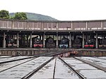
|
38°26′S 72°22′W / 38.44°S 72.37°W |
1 September 1998 | Cultural (iv) |
1200 | "Railroad officially arrived at Temuco the very first day of 1893. It is believed that the first locomotive depot was located a few meters to the north of the present one, in lots handed over to the State Railroad Company by mapuche people. Temuco turned into an important railroad center, where long-run trains changed locomotives. That depot also housed the locomotives of the trains covering the branch lines to towns such as Carahue, Cunco and Cherquenco. During the first decades of this century, complex locomotive repair and maintenance works were performed in the Temuco locomotive depot. After the San Bernardo Machine Shop started operating in 1920, the Temuco depot kept on doing uncomplicated repairs."[21] |
| Malleco Viaduct | 
|
37°35′S 72°16′W / 37.58°S 72.27°W |
1 September 1998 | Cultural (i)(iv) |
1199 | "The Malleco Viaduct was in its time considered the highest railroad bridge in the world. It is one of the largest works of metal engineering in Chile. It was built within the setting of an ambitious state program to extend the railroad network, which President José Manuel Balmaceda deemed fundamental for the economic future of the country. The work was part of the construction of the railroad line between Angol and Traiguén, made by the Chilean State through a public bidding. The passage through the Malleco River valley presented the main problem for the layout, since the riverbed runs 110 meters below the level of the plains. "[22] |
| Monte Verde Archaeological Site | 
|
30°10′S 73°07′W / 30.17°S 73.12°W 41°18′S 73°07′W / 41.30°S 73.12°W |
23 February 2004 | Cultural (iii)(iv) |
1873 | "The Monte Verde archaeological site locates in the region of the sub-Antarctic and evergreen softwood forest, in the low mountains of the South of Chile. There, the site shows the existence of a group of people that lived there throughout the beaches and banks of sand and gravel of a small stream about 14.800 years ago according to the calibrated dates of carbon 14. After the occupation of this site, a turf coating formed by a swamp covered the entire site and allowed the conservation of this impression of the human past. The archaeological works of the Austral University of Chile achieved the discovery of these rests of housing, wood devices, vegetal food rests, such as wild potatoes, and animal bones among which there are rests of 5 or 6 mastodons, as carrion or hunting food, showing an early human fitness to "Valdiviano" type humid temperate forest."[23] |
| Rupestrian art of the Patagonia | 
|
46°06′S 72°06′W / 46.10°S 72.10°W 46°18′S 72°00′W / 46.30°S 72.00°W 53°17′S 70°26′W / 53.29°S 70.44°W |
1 September 1998 | Cultural (i)(ii)(iii) |
1203 | "Near Lake General Carrera, to the east of the southern Andes, there are manifestations of rupestrian art constituting the so-called "Patagonian Art Style", which is the oldest in South America. Its best known representations are those of hands, the scenes depicting guanacos, and the frets which, although ill preserved, reach up to some eaves of the pampas region stretching to the north of the Magallanes Strait. Due to the isolation of the Patagonia regarding cultural streams, the basic characteristics of the style remained unaltered for millenniums. Proof of it are the paintings of the rocky shelter Los Toldos in central Patagonia, over the Atlantic coast, which are nearly 10,000 years old. In later times, these artistic manifestations especially developed in east Patagonia, but also in the sub-Andean area to the west of the Chilean-Argentinian borderline, at some points where the conditions of the geographic environment of Chile maintain some pampa features."[24] |
| San Francisco Church and Convent | 
|
33°16′S 70°24′W / 33.27°S 70.40°W |
1 September 1998 | Cultural (ii)(iv) |
1196 | "The San Francisco Church and Convent originated from the Ermita del Socorro, a small hermitage built for lodging the image of the Virgin of that name, brought into the country by the Spanish conquistador and founder of Santiago, Pedro de Valdivia. This image, carved and painted in Italy, was much revered both by Valdivia and his comrades-in-arms, who attributed to its mediation the fact of having survived the natives' attacks. The veneration for this image kept its strength throughout the Colony, and has lasted till this day. In 1554, in exchange for twelve lots facing the Cerro Santa Lucia, the Franciscan Order got into the obligation of building a church to lodge the image sheltered in the Ermita."[25] |
| San Pedro de Atacama | 
|
22°33′S 68°07′W / 22.55°S 68.12°W |
1 September 1998 | Cultural (ii)(iii)(v) |
1191 | "The Atacama area has a desert-like climate, with big differences of temperature between day and night, and summer rains which do not surpass 100 millimeters per year. The main water sources are the San Pedro and Vilama rivers. The area's chief geographic element is the Solar de Atacama, occupying a surface 100 kilometers long by 80 km. wide. The salt mine is a result of the surfacing of underground waters saturated with mineral salts which, on evaporating, leave a crust rich in salts and minerals. The rivers, fed by the Andean snows, irrigate the area allowing the configuration of numerous oasis. This is the scenario where the Atacama culture developed. "[26] |
| The Defensive Complex of Valdivia | 
|
39°29′S 73°09′W / 39.49°S 73.15°W 39°30′S 73°15′W / 39.50°S 73.25°W |
1 September 1998 | Cultural (i)(iii)(iv) |
1202 | "The Spanish Crown early perceived the strategic nature of Ghilets southernmost region which, through the Magallanes Strait and Cape Horn, was an intermediate point for navigation from Europe to the American Pacific coast. From the end of the XVI century, the construction of fortifications in this area became a high priority due to the frequent transit of French, English and Dutch ships and, particularly, to pirates' raids. To the destruction in the Chilean and Peruvian coast caused by Francis Drake in 1578, were added expeditions like that of the Dutch Hendrik Brouwer, who, in 1643, occupied for a time the littoral adjacent to the mouth of the Valdivia river, with the purpose of challenging from there the Spanish might. These incidents led the Spanish authorities to undertake the construction of powerful defensive facilities in Valdivia, Valparaiso and Chiloé. Valdivia, the oldest of the three, would become, along with El Callao, the most important defensive complex of the American South Pacific coast."[27] |
| Torres del Paine and Bernardo O'Higgins National Parks, Region of Magallanes | 
|
51°00′S 73°00′W / 51.00°S 73.00°W |
30 March 1994 | Natural (x) |
85 | "Torres del Paine and Bernardo O'Higgins National Parks include over 90% of the Southern Patagonian Icefield; the remainder of it, across the border in Argentina, is included within Los Glaciares National Park (W.H.Site). The area of the proposed site is 37.073 sq.km. Besides the icefield that follows the main Andes range for approximately 350 km in a north-south direction, the site includes outlying ranges such as the Paine Massif, well known as a scenic area and as a challenging mountain climbing destination. To the west, the site extends to the open waters of the Pacific Ocean through a maze of fiords and islands, that show different examples and stages of glacial action and periglacial ecosystems succession. The area was given National Park status by successive decrees issued from 1959 through 1975."[28] |


See also edit
References and notes edit
- ^ "The World Heritage Convention". UNESCO. Retrieved 31 October 2015.
- ^ "Chile – Properties inscribed on the World Heritage List". UNESCO. Retrieved 31 October 2015.
- ^ "Rapa Nui National Park". Paris: UNESCO. Retrieved 11 December 2017.
- ^ "Churches of Chiloé". Paris: UNESCO. Retrieved 11 December 2017.
- ^ "Historic Quarter of the Seaport City of Valparaíso". Paris: UNESCO. Retrieved 11 December 2017.
- ^ "Humberstone and Santa Laura Saltpeter Works". Paris: UNESCO. Retrieved 11 December 2017.
- ^ "The Humberstone and Santa Laura Saltpeter Works site (Chile), removed from the List of World Heritage in Danger". UNESCO. Retrieved 7 July 2019.
- ^ "Sewell Mining Town". Paris: UNESCO. Retrieved 11 December 2017.
- ^ "Qhapaq Ñan, Andean Road System". Paris: UNESCO. Retrieved 11 December 2017.
- ^ "Archaeological sites of the Chinchorro culture". Paris: UNESCO. Retrieved 24 September 2017.
- ^ "UNESCO World Heritage Centre – Tentative Lists". Paris: UNESCO. Retrieved 11 December 2017.
- ^ "UNESCO World Heritage Centre – Tentative Lists: Chile". Paris: UNESCO. Retrieved 11 December 2017.
- ^ "Ayquina and Toconce". Paris: UNESCO. Retrieved 24 September 2017.
- ^ "Baquedano Street". Paris: UNESCO. Retrieved 24 September 2017.
- ^ "Cerro El Plomo high shrine". Paris: UNESCO. Retrieved 24 September 2017.
- ^ "Churches of the Altiplano". Paris: UNESCO. Retrieved 24 September 2017.
- ^ "Fell and Pali Aike Caves". Paris: UNESCO. Retrieved 24 September 2017.
- ^ "Houses of the hacienda San José del Carmen el Huique". Paris: UNESCO. Retrieved 24 September 2017.
- ^ "Juan Fernández Archipelago National Park". Paris: UNESCO. Retrieved 24 September 2017.
- ^ "La Moneda Palace". Paris: UNESCO. Retrieved 24 September 2017.
- ^ "Locomotive depot of the Temuco Railroad Station". Paris: UNESCO. Retrieved 24 September 2017.
- ^ "Malleco Viaduct". Paris: UNESCO. Retrieved 24 September 2017.
- ^ "Monte Verde Archeological Site". Paris: UNESCO. Retrieved 24 September 2017.
- ^ "Rupestrian art of the Patagonia". Paris: UNESCO. Retrieved 24 September 2017.
- ^ "San Francisco Church". Paris: UNESCO. Retrieved 24 September 2017.
- ^ "San Pedro de Atacama". Paris: UNESCO. Retrieved 24 September 2017.
- ^ "The Defensive Complex of Valdivia". Paris: UNESCO. Retrieved 24 September 2017.
- ^ "Torres del Paine and Bernardo O'Higgins National Parks, Region of Magallanes". Paris: UNESCO. Retrieved 24 September 2017.
External links edit
- Chile at UNESCO World Heritage Convention