
KNOWPIA
WELCOME TO KNOWPIA

List of bridges in Ottawa 
Summary
This is a list of bridges in Ottawa, Ontario, Canada. They are listed from west to east and north to south. Bridges spanning Airport Parkway, the Confederation Line, Green's Creek, Highway 174, Highway 416, Highway 417, the Jock River, the Transitway, and the Trillium Line are not listed.
Spanning the Ottawa River edit
| Bridge | Carries | Length | Built | Coordinates | Image | Remarks |
|---|---|---|---|---|---|---|
| Morris Island Train Bridge | Pedestrian pathway | 498 m | 1915 | 45°27′59.26″N 76°17′10.57″W / 45.4664611°N 76.2862694°W | Originally carried Canadian Northern Railway (1915—1998) and the Ottawa Central Railway (1998—2008). Converted into a pedestrian bridge in 2014. Fitted to accommodate snowmobiles in 2022.[1] | |
| Champlain Bridge | Place Samuel-De Champlain Island Park Drive |
1010 m | 1928 | 45°24′35.5″N 75°45′34.7″W / 45.409861°N 75.759639°W | 
|
Crosses Bate Island, Cunningham Island, and Riopelle Island. Longest bridge in Ottawa. |
| Lemieux Island Bridge | Onigam Street | 215 m | 1919 | 45°24′50.1″N 75°43′52.23″W / 45.413917°N 75.7311750°W | 
|
Crosses Bell Island. |
| Chief William Commanda Bridge | Pedestrian pathway | 992 m | 1880 | 45°24′46.28″N 75°43′33.76″W / 45.4128556°N 75.7260444°W | 
|
Crosses Lemieux Island. Originally carried the Quebec, Montreal, Ottawa and Occidental Railway (1880—1882) and the Canadian Pacific Railway (1882—2005). Converted into a pedestrian bridge in 2023. |
| Chaudière Bridge | Chaudière Crossing | 99 m | 1919 | 45°25′16″N 75°43′07″W / 45.42111°N 75.71861°W | 
|
Site of the first bridge linking Ottawa and Gatineau. |
| Portage Bridge | 700 m | 1973 | 45°25′20″N 75°42′49″W / 45.42222°N 75.71361°W | 
|
Crosses Victoria Island. | |
| Alexandra Bridge | 563 m | 1900 | 45°25′47.81″N 75°42′13.54″W / 45.4299472°N 75.7037611°W | 
|
Originally carried the Canadian Pacific Railway (1900—1966). | |
| Macdonald-Cartier Bridge | Autoroute 5 | 618 m | 1963 | 45°26′12″N 75°42′9″W / 45.43667°N 75.70250°W | 
|
Spanning the Rideau River edit
| Bridge | Carries | Length | Built | Coordinates | Image | Remarks |
|---|---|---|---|---|---|---|
| Bytown Bridge (West Bridge) | Sussex Drive | 70 m | 2005 | 45°26′21.88″N 75°41′45.51″W / 45.4394111°N 75.6959750°W | Replaced the original bridge built in 1954. | |
| Bytown Bridge (East Bridge) | Sussex Drive | 84 m | 2005 | 45°26′28.23″N 75°41′41.31″W / 45.4411750°N 75.6948083°W | 
|
Replaced the original bridge built in 1954. |
| Minto Bridge (West Bridge) | Union Street | 61 m | 1900 | 45°26′17.68″N 75°41′35.42″W / 45.4382444°N 75.6931722°W | 
|
|
| Minto Bridge (East Bridge) | Union Street | 112 m | 1900 | 45°26′22.93″N 75°41′31.84″W / 45.4397028°N 75.6921778°W | 
|
Crosses Maple Island. |
| Island Lodge Road | 92 m | 1964 | 45°26′12.52″N 75°40′55.62″W / 45.4368111°N 75.6821167°W | |||
| Porter Island Bridge | Pedestrian pathway (closed) | 78 m | 1894 | 45°26′12.4″N 75°40′50.48″W / 45.436778°N 75.6806889°W | ||
| St. Patrick Street Bridge | St. Patrick Street | 163 m | 1975 | 45°26′15.03″N 75°40′43.08″W / 45.4375083°N 75.6786333°W | ||
| Cummings Bridge | Rideau Street | 213 m | 1921 | 45°25′59.58″N 75°40′16.59″W / 45.4332167°N 75.6712750°W | 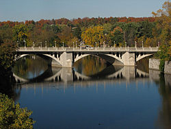
|
|
| Adàwe Crossing | Pedestrian pathway | 125 m | 2015 | 45°25′34.85″N 75°40′12.51″W / 45.4263472°N 75.6701417°W | 
|
|
| Provincial Constable J. Robert Maki Bridge | Highway 417 | 159 m | 1955 | 45°25′1.19″N 75°39′46.48″W / 45.4169972°N 75.6629111°W | ||
| Rideau River Pedestrian/Cycling Bridge | Pedestrian pathway | 160 m | 1909 | 45°24′58.86″N 75°39′46.38″W / 45.4163500°N 75.6628833°W | Originally carried the Canadian National Railway (1909—1966). Converted into a pedestrian bridge in 1970.[2] | |
| Hurdman Bridge | Confederation Line | 159 m | 1983 | 45°24′51.18″N 75°40′7.05″W / 45.4142167°N 75.6686250°W | 
|
Originally carried the Transitway.[3] |
| George McIlraith Bridge | Smyth Road | 240 m | 1965 | 45°23′58.69″N 75°40′15.3″W / 45.3996361°N 75.670917°W | 
|
[4] |
| Billings Bridge | Bank Street | 140 m | 1916 | 45°23′21.41″N 75°40′40.53″W / 45.3892806°N 75.6779250°W | 
|
|
| George Dunbar Bridge | Bronson Avenue | 268 m | 1996 | 45°22′59.79″N 75°41′19.56″W / 45.3832750°N 75.6887667°W | 
|
Replaced the original bridge built in 1955. |
| Rideau River Bridge | Trillium Line | 100 m | 1914 | 45°22′55.03″N 75°41′41.81″W / 45.3819528°N 75.6949472°W | 
|
Originally carried the Canadian Pacific Railway (1914—2001). |
| Heron Road Workers Memorial Bridge | Heron Road | 276 m | 1967 | 45°22′33.01″N 75°41′59.54″W / 45.3758361°N 75.6998722°W | 
|
Also spans the Rideau Canal. |
| Hog's Back Fixed Bridge | Hog's Back Road | 69 m | 1977 | 45°22′14.94″N 75°41′47.42″W / 45.3708167°N 75.6965056°W | ||
| Canadian Northern Ontario Railway Bridge | Canadian National Railway | 138 m | 1913 | 45°20′44.39″N 75°41′52.09″W / 45.3456639°N 75.6978028°W | 
|
Originally carried the Canadian Northern Railway (1913—1923). |
| Michael J. E. Sheflin Bridge | Hunt Club Road | 230 m | 1985 | 45°20′2.86″N 75°41′46.51″W / 45.3341278°N 75.6962528°W | 
|
|
| Vimy Memorial Bridge | Strandherd Drive | 144 m | 2014 | 45°16′11.89″N 75°42′9.34″W / 45.2699694°N 75.7025944°W | 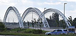
|
|
| Nicolls Island Road | 22 m | 1903 | 45°15′1.95″N 75°42′7.08″W / 45.2505417°N 75.7019667°W | The bridge structure which originally spanned the Rideau Canal was moved to Nicolls Island in 1935.[5] | ||
| Long Island Dam | Cecil Rowat Lane | 48 m | 1920 | 45°14′56.94″N 75°42′11.52″W / 45.2491500°N 75.7032000°W | ||
| Bridge Street (West Bridge) | Bridge Street | 85 m | 1956 | 45°13′41.57″N 75°41′1.07″W / 45.2282139°N 75.6836306°W | ||
| Bridge Street (East Bridge) | Bridge Street | 108 m | 1958 | 45°13′54.87″N 75°40′47.03″W / 45.2319083°N 75.6797306°W | ||
| Watson's Mill Dam | Pedestrian pathway | 60m | 1956 | 45°13′37.39″N 75°40′56.68″W / 45.2270528°N 75.6824111°W | 
|
Replaced the original dam built in 1856.[6][7] |
| Roger Stevens Drive | 174 m | 1961 | 45°9′42.92″N 75°38′2.34″W / 45.1619222°N 75.6339833°W | |||
| Constable Hiram O'Callaghan Memorial Bridge | Highway 416 | 290 m | 1996 | 45°4′57.89″N 75°38′17.39″W / 45.0827472°N 75.6381639°W | ||
| Beckett's Landing Bridge | Merlyn Wilson Road | 143 m | 1991 | 45°2′50.73″N 75°40′48.24″W / 45.0474250°N 75.6800667°W | Replaced the original bridge built in 1937.[8] |
Spanning the Rideau Canal edit
| Bridge | Carries | Length | Built | Coordinates | Image | Remarks |
|---|---|---|---|---|---|---|
| Plaza Bridge | Wellington Street Rideau Street Elgin Street |
65 m | 1912 | 45°25′28.86″N 75°41′41.33″W / 45.4246833°N 75.6948139°W | 
|
Replaced Sappers Bridge and Dufferin Bridge. |
| Mackenzie King Bridge | 101 m | 1951 | 45°25′24.35″N 75°41′28.63″W / 45.4234306°N 75.6912861°W | 
|
||
| Laurier Avenue Bridge | Laurier Avenue | 91 m | 1900 | 45°25′21.35″N 75°41′21.11″W / 45.4225972°N 75.6891972°W | 
|
|
| Corktown Footbridge | Pedestrian pathway | 70 m | 2006 | 45°25′13.98″N 75°41′4.42″W / 45.4205500°N 75.6845611°W | 
|
|
| Highway 417 | 122 m | 1965 | 45°24′44.43″N 75°41′0.27″W / 45.4123417°N 75.6834083°W | 
|
||
| Pretoria Bridge | Hawthorne Avenue | 58 m | 1915 | 45°24′41.58″N 75°40′59.91″W / 45.4115500°N 75.6833083°W | 
|
|
| Flora Footbridge | Pedestrian pathway | 125 m | 2019 | 45°24′18.46″N 75°40′51.87″W / 45.4051278°N 75.6810750°W | 
|
|
| Bank Street Bridge | Bank Street | 112 m | 1912 | 45°23′46.72″N 75°41′4.42″W / 45.3963111°N 75.6845611°W | 
|
|
| Bronson Avenue Bridge | Bronson Avenue | 88 m | 1959 | 45°23′38.48″N 75°41′45.97″W / 45.3940222°N 75.6961028°W | 
|
|
| Heron Road Workers Memorial Bridge | Heron Road | 276 m | 1967 | 45°22′32.16″N 75°42′7.93″W / 45.3756000°N 75.7022028°W |
|
Also spans the Rideau River. |
| Hog's Back Swing Bridge | Hog's Back Road | 27 m | 1976 | 45°22′11.26″N 75°41′54.96″W / 45.3697944°N 75.6986000°W | 
|
Spanning Patterson Creek (Ottawa) edit
| Bridge | Carries | Length | Built | Coordinates | Image | Remarks |
|---|---|---|---|---|---|---|
| O'Connor Street Bridge | O'Connor Street | 12 m | 1907 | 45°24′24.48″N 75°41′10.76″W / 45.4068000°N 75.6863222°W | 
|
|
| Queen Elizabeth Driveway Bridge | Queen Elizabeth Driveway | 10 m | c. 1912 | 45°24′28.92″N 75°40′55.4″W / 45.4080333°N 75.682056°W | 
|
Spanning Nepean Inlet edit
| Bridge | Carries | Length | Built | Coordinates | Image | Remarks |
|---|---|---|---|---|---|---|
| Nepean Bay Bridge | Trans Canada Trail | 30 m | 2005 | 45°24′49.52″N 75°43′11.32″W / 45.4137556°N 75.7198111°W | Spans Nepean Bay. | |
| LeBreton Bridge | Kichi Zibi Mikan | 66 m | 2005 | 45°24′50.04″N 75°43′9.47″W / 45.4139000°N 75.7192972°W | Spans Nepean Bay. | |
| Booth Street Bridge | Pedestrian pathway | 20 m | 1874 | 45°24′50.93″N 75°42′48.37″W / 45.4141472°N 75.7134361°W | Spans the Fleet Street Aqueduct. Originally carried Booth Street. | |
| Pooley's Bridge | Pedestrian pathway | 35 m | 1873 | 45°24′59.71″N 75°42′38.93″W / 45.4165861°N 75.7108139°W | 
|
Spans the Fleet Street Aqueduct. Oldest bridge in Ottawa. |
See also edit
Wikimedia Commons has media related to Bridges in Ottawa.
References edit
- ^ Churcher, Colin. "The Bridge over the Ottawa River at Fitzroy". Colin Churcher's Railway Pages.
- ^ "Hurdman Train Bridge". Capital Gems.
- ^ "History of Hurdman Station". Rail Fans.
- ^ Elliott, Kim. "George McIlraith Bridge". Bridges of Ottawa.
- ^ "Nicolls Island Road Bridge". Historic Bridges. Retrieved 30 March 2022.
- ^ "History". Watson's Mill.
- ^ "1900 – 1963". Watson's Mill.
- ^ "The Rideau River Bridge on old Highway 16". The North Grenville Times.