
KNOWPIA
WELCOME TO KNOWPIA

List of covered bridges in California 
Summary

Below is a list of covered bridges in California. There are ten authentic covered bridges in the U.S. state of California, and eight of them are historic.[1] A covered bridge is considered authentic not due to its age, but by its construction. An authentic bridge is constructed using trusses rather than other methods such as stringers, a popular choice for non-authentic covered bridges.
List edit
| Name | Image | County | Location | Built | Length | Crosses | Ownership | Truss | Notes |
|---|---|---|---|---|---|---|---|---|---|
| Berta's Ranch Covered Bridge[1] | 
|
Humboldt | Rosewood 40°43′28″N 124°10′37″W / 40.72444°N 124.17694°W |
1936 | 52 feet (16 m) | Elk River | Queen | ||
| Bridgeport Covered Bridge[2] | 
|
Nevada | French Corral 39°17′33″N 121°11′42″W / 39.29250°N 121.19500°W |
1862 | 233 feet (71 m) | South Yuba River | Nevada County Division of Highways | Howe and arch | |
| Brookwood Covered Bridge[1] | Humboldt | Bayside 40°49′55″N 124°2′44″W / 40.83194°N 124.04556°W |
1969 | 66 feet (20 m) | Jacoby Creek | Howe | |||
| California Powder Works Bridge[2] | 
|
Santa Cruz | Santa Cruz 37°0′38″N 122°2′38″W / 37.01056°N 122.04389°W |
1872 | 180 feet (55 m) | San Lorenzo River | Private | Smith | Also called Masonic Park Covered Bridge |
| Felton Covered Bridge[2] | 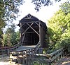
|
Santa Cruz | Felton 37°03′03″N 122°04′15″W / 37.05083°N 122.07083°W |
1892 | 163 feet (50 m) | San Lorenzo River | County of Santa Cruz | Pratt-Warren | |
| Knight's Ferry Bridge[2] | 
|
Stanislaus | Knight's Ferry 37°39′48″N 120°27′44″W / 37.66333°N 120.46222°W |
1864 | 379 feet (116 m)[3] | Stanislaus River | U.S. Army Corps of Engineers, Sacramento District | Howe | |
| Oregon Creek Covered Bridge[2] | 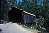
|
Yuba | North San Juan 39°23′48″N 121°4′52″W / 39.39667°N 121.08111°W |
1860 | 105 feet (32 m) | Oregon Creek | County of Yuba | Queen | Also called Freeman's Crossing Covered Bridge |
| Simpson Ranch Covered Bridge[1] | Placer | Meadow Vista 39°0′36″N 121°0′40″W / 39.01000°N 121.01111°W |
22 feet (6.7 m) | Wooley Creek | King | Also called Foothill Roots Farm Covered Bridge | |||
| Wawona Covered Bridge[2] | 
|
Mariposa | Wawona 37°32′19″N 119°39′17″W / 37.53861°N 119.65472°W |
1868, 1878, 1956 | 138 feet (42 m) | South Fork, Merced River | Yosemite National Park | Modified queen | |
| Zane's Ranch Covered Bridge[1] | 
|
Humboldt | Rosewood 40°43′4″N 124°10′8″W / 40.71778°N 124.16889°W |
1937 | 52 feet (16 m) | Elk River | Queen |
See also edit
References edit
- ^ a b c d e Caswell, William S. World Guide to Covered Bridges (2021 ed.). Concord, New Hampshire: National Society for Preservation of Covered Bridges. pp. 3–4. ISBN 978-0-578-30263-8.
- ^ a b c d e f "National Register Information System". National Register of Historic Places. National Park Service. July 9, 2010.
- ^ "Updates to the 2021 World Guide to Covered Bridges" (PDF). National Society for Preservation of Covered Bridges. 28 June 2022. Retrieved 6 July 2022.
External links edit
Wikimedia Commons has media related to Covered bridges in California.
- National Society for the Preservation of Covered Bridges
- Only in Your State article about the state's covered bridges