
KNOWPIA
WELCOME TO KNOWPIA

List of crossings of the Connecticut River 
Summary
This is a list of bridges and other crossings of the Connecticut River from its mouth at Long Island Sound upstream to its source at the Connecticut Lakes. The list includes current road and rail crossings, as well as ferries carrying a state highway across the river. Some pedestrian bridges and abandoned bridges are also listed.

This transport-related list is incomplete; you can help by adding missing items. (August 2008) |
Crossings edit
| Crossing | Carries | Location | Built | Coordinates | Image |
|---|---|---|---|---|---|
Connecticut edit | |||||
| Amtrak Old Saybrook – Old Lyme Bridge | Amtrak Northeast Corridor | Old Saybrook and Old Lyme | 1907 | 41°18′39″N 72°20′57″W / 41.31083°N 72.34917°W | |
| Raymond E. Baldwin Bridge | 1948, 1993 | 41°19′09″N 72°20′51″W / 41.31917°N 72.34750°W | |||
| Chester–Hadlyme Ferry | Chester and Lyme | 1769 | 41°25′11″N 72°25′50″W / 41.41972°N 72.43056°W | 
| |
| East Haddam Bridge | Haddam and East Haddam | 1913 | 41°27′05″N 72°27′52″W / 41.45139°N 72.46444°W | 
| |
| Providence and Worcester railroad bridge | Middletown and Portland | 41°34′00″N 72°38′52″W / 41.56667°N 72.64778°W | |||
| Arrigoni Bridge | 1938 | 41°34′09″N 72°38′55″W / 41.56917°N 72.64861°W | 
| ||
| Rocky Hill – Glastonbury Ferry | Rocky Hill and Glastonbury | 1655 | 41°39′57″N 72°37′40″W / 41.66583°N 72.62778°W | 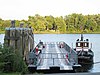
| |
| William H. Putnam Memorial Bridge | Wethersfield and Glastonbury | 1959 | 41°42′51″N 72°38′27″W / 41.71417°N 72.64083°W | 
| |
| Charter Oak Bridge | Hartford and East Hartford | 1942, 1991 | 41°45′11″N 72°39′18″W / 41.75306°N 72.65500°W | 
| |
| Founders Bridge | 1958 | 41°45′56″N 72°39′55″W / 41.76556°N 72.66528°W | 
| ||
| Morgan G. Bulkeley Bridge | 1908 (widened 1964) | 41°46′09″N 72°39′54″W / 41.76917°N 72.66500°W | 
| ||
| Connecticut Southern railroad bridge | c. 1873 | 41°46′35″N 72°39′27″W / 41.77639°N 72.65750°W | 
| ||
| Captain John Bissell Memorial Bridge | Windsor and South Windsor | 1957 | 41°48′47″N 72°38′40″W / 41.81306°N 72.64444°W | ||
| Dexter Coffin Bridge | Windsor Locks and East Windsor | 1959 | 41°55′00″N 72°37′22″W / 41.91667°N 72.62278°W | 
| |
| Bridge Street Bridge | 1992 | 41°55′45″N 72°37′27″W / 41.92917°N 72.62417°W | |||
| Warehouse Point railroad bridge | Amtrak New Haven – Springfield Line | Suffield and Enfield | 1903 | 41°56′36″N 72°36′50″W / 41.94333°N 72.61389°W | |
| Enfield–Suffield Covered Bridge (destroyed 1900) | 1832 | 41°58′30.34″N 72°36′22.31″W / 41.9750944°N 72.6061972°W | 
| ||
| Enfield–Suffield Veterans Bridge | 1966 | 41°59′23″N 72°36′13″W / 41.98972°N 72.60361°W | |||
| Suffield and Thompsonville Bridge (demolished 1971) | 1893 | 41°59′57″N 72°36′25.56″W / 41.99917°N 72.6071000°W | 
| ||
Massachusetts edit | |||||
| Julia B. Buxton Bridge (South End Bridge) | Agawam and Springfield | 1954 | 42°04′53″N 72°34′58″W / 42.08139°N 72.58278°W | 
| |
| Memorial Bridge | West Springfield and Springfield | 1922 | 42°05′56″N 72°35′42″W / 42.09889°N 72.59500°W | 
| |
| Old Toll Bridge (demolished) | 1816 | 42°5′59.68″N 72°35′46.47″W / 42.0999111°N 72.5962417°W | 
| ||
| CSX Berkshire rail bridge | CSX Berkshire Subdivision | 1873 | 42°06′05″N 72°35′57″W / 42.10139°N 72.59917°W | 
| |
| Arthur J. McKenna Bridge (North End Bridge) | 1924 | 42°06′31″N 72°36′51″W / 42.10861°N 72.61417°W | 
| ||
| I-91 bridge | West Springfield and Chicopee | 1966 | 42°08′07″N 72°36′55″W / 42.13528°N 72.61528°W | 
| |
| Chicopee – West Springfield Bridge (demolished 1987) | 42°8′38.39″N 72°37′7.11″W / 42.1439972°N 72.6186417°W | 
| |||
| Massachusetts Turnpike bridge | 1957 | 42°09′14″N 72°37′40″W / 42.15389°N 72.62778°W | 
| ||
| Jones Ferry | Holyoke and Chicopee | 42°10′18″N 72°37′43″W / 42.17167°N 72.62861°W | 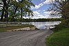
| ||
| I-391 bridge | 1979 | 42°11′24″N 72°36′36″W / 42.19000°N 72.61000°W | 
| ||
| Willimansett Bridge | 1891, 2015 | 42°11′42″N 72°36′05″W / 42.19500°N 72.60139°W | 
| ||
| Springfield Terminal railroad bridge | 42°11′43″N 72°36′02″W / 42.19528°N 72.60056°W | 
| |||
| Vietnam Memorial Bridge | Holyoke and South Hadley | 1990 | 42°12′42″N 72°35′46″W / 42.21167°N 72.59611°W | ||
| Joseph E. Muller Bridge | 1958 | 42°12′58″N 72°36′28″W / 42.21611°N 72.60778°W | |||
| Northampton Toll Bridge | Northampton and Hadley | 1808 | 42°20′11″N 72°37′04″W / 42.33639°N 72.61778°W | ||
| Calvin Coolidge Bridge | 1937 | 42°20′11″N 72°37′04″W / 42.33639°N 72.61778°W | |||
| Norwottuck Rail Trail Bridge | Norwottuck Rail Trail | 1887 | 42°20′14″N 72°37′07″W / 42.33722°N 72.61861°W | 
| |
| Hatfield Bridge (dismantled 1823) | Toll Bridge passed by state legislature March 8, 1803 without funding. Town purchase it by lottery, was completed October 20, 1807 and dismantled on July 7, 1823. Bridge was located on Bridge Lane, Hatfield, MA | Hatfield and Hadley | 1807 | 42°21′55.44″N 72°35′21.65″W / 42.3654000°N 72.5893472°W | |
| Sunderland Bridge | Deerfield and Sunderland | 1937 | 42°28′03″N 72°35′06″W / 42.46750°N 72.58500°W | 
| |
| Springfield Terminal railroad bridge | Deerfield and Montague | 42°33′44″N 72°33′22″W / 42.56222°N 72.55611°W | 
| ||
| Canalside Rail Trail Bridge | Deerfield and Montague | c. 1880, 1936 | 42°34′45.30″N 72°34′29.53″W / 42.5792500°N 72.5748694°W | 
| |
| Montague City Covered Bridge (destroyed 1936) | Greenfield and Montague | 42°34′49.1″N 72°34′44.9″W / 42.580306°N 72.579139°W (approx.) | 
| ||
| Montague trolley bridge (destroyed 1936) | 42°34′49.1″N 72°34′45.9″W / 42.580306°N 72.579417°W (approx.) | ||||
| General Pierce Bridge | 1947 | 42°34′49″N 72°34′47″W / 42.58028°N 72.57972°W | |||
| Turners Falls Road Bridge | 1936 | 42°36′33″N 72°33′41″W / 42.60917°N 72.56139°W | 
| ||
| Gill–Montague Bridge | Gill and Montague | 1937 | 42°36′40″N 72°33′11″W / 42.61111°N 72.55306°W | ||
| French King Bridge | Gill and Erving | 1931 | 42°35′52″N 72°29′48″W / 42.59778°N 72.49667°W | ||
| Bennett's Meadow Bridge | Northfield | 1969 | 42°41′00″N 72°28′18″W / 42.68333°N 72.47167°W | 
| |
| Rail bridge | New England Central Railroad | 1903 | 42°42′22.40″N 72°27′33″W / 42.7062222°N 72.45917°W | ||
| Schell Bridge (closed) | 1903 | 42°42′44″N 72°27′12″W / 42.71222°N 72.45333°W | 
| ||
Vermont – New Hampshire edit | |||||
| Rail bridge (demolished) | Boston and Maine Railroad Fort Hill Branch (former) | Vernon and Hinsdale | 1913 | 42°44′14″N 72°27′45″W / 42.737098°N 72.462587°W | |
| Rail bridge (partially demolished) | Boston and Maine Railroad Cheshire Branch (former) | Brattleboro and Hinsdale | 42°50′16.38″N 72°32′46.21″W / 42.8378833°N 72.5461694°W | 
| |
| VT/NH Route 119 bridge | 1920 | 42°51′05″N 72°33′10″W / 42.85139°N 72.55278°W | 
| ||
| United States Navy Seabees Bridge | Brattleboro and Chesterfield | 2003 | 42°53′02″N 72°33′07″W / 42.88389°N 72.55194°W | 
| |
| Route 123 bridge | Westminster and Walpole | 1910 | 43°05′04″N 72°26′00″W / 43.08444°N 72.43333°W | 
| |
| Vilas Bridge (closed) | Bellows Falls and North Walpole | 1930 | 43°08′07″N 72°26′25″W / 43.13528°N 72.44028°W | 
| |
| Stone Arch Bridge | Vermont Rail (Green Mountain) | 43°08′09″N 72°26′25″W / 43.13583°N 72.44028°W | |||
| New England Central railroad bridge | 43°08′17″N 72°26′48″W / 43.13806°N 72.44667°W | ||||
| Arch Bridge | 1984 | 43°08′17″N 72°26′54″W / 43.13806°N 72.44833°W | |||
| Cheshire Bridge | Springfield and Charlestown | 1806,1906,1930 | 43°15′37″N 72°25′38″W / 43.26028°N 72.42722°W | ||
| Route 12 bridge | Ascutney and Claremont | 1969 | 43°24′11″N 72°24′01″W / 43.40306°N 72.40028°W | 
| |
| New England Central railroad bridge | Windsor and Cornish | 43°28′11″N 72°23′19″W / 43.46972°N 72.38861°W | |||
| Cornish–Windsor Covered Bridge | 1866 | 43°28′25″N 72°23′01″W / 43.47361°N 72.38361°W | 
| ||
| I-89 bridge | Hartford and Lebanon | 1966 | 43°38′03″N 72°19′43″W / 43.63417°N 72.32861°W | ||
| Railroad bridge | White River Junction and West Lebanon | 43°38′49″N 72°18′48″W / 43.64694°N 72.31333°W | |||
| US-4 bridge | 1936, 2015 | 43°39′02″N 72°18′51″W / 43.65056°N 72.31417°W | |||
| Ledyard Bridge | Norwich and Hanover | 1998 | 43°42′13″N 72°17′59″W / 43.70361°N 72.29972°W | 
| |
| Lyme–East Thetford Bridge | East Thetford Road |
East Thetford and Lyme | 1937 | 43°48′43″N 72°10′59″W / 43.81194°N 72.18306°W | |
| Morey Memorial Bridge | Fairlee and Orford | 1937 | 43°54′25″N 72°08′22″W / 43.90694°N 72.13944°W | 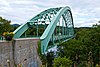
| |
| Piermont Bridge | Bradford and Piermont | 1929 | 43°58′40″N 72°06′43″W / 43.97778°N 72.11194°W | 
| |
| Bedell Covered Bridge (destroyed by wind, 1979) | South Newbury and Haverhill | 1805, 1823, 1862, 1866, 1979 | 44°02′43″N 72°04′27″W / 44.04528°N 72.07417°W | 
| |
| Newbury Crossing Road | Newbury and Haverhill | 1970 | 44°03′58″N 72°03′05″W / 44.06611°N 72.05139°W | ||
| Ranger Bridge | Wells River and Woodsville | 1917, 1923 | 44°09′14″N 72°02′27″W / 44.15389°N 72.04083°W | 
| |
| Wells River Bridge (closed) | Boston and Maine Corporation (railroad, upper level), road (lower level, until 1917) | 1805, 1853, 1903 | 44°09′15″N 72°02′26″W / 44.15417°N 72.04056°W | 
| |
| Frazier Road bridge | McIndoe Falls and Monroe | 1937 | 44°15′42″N 72°03′32″W / 44.26167°N 72.05889°W | ||
| Barnet Road bridge | Barnet and Monroe | 1930 | 44°17′13″N 72°03′25″W / 44.28694°N 72.05694°W | ||
| I-93 bridge | Waterford and Littleton | 1976, 1981 | 44°20′34″N 71°53′27″W / 44.34278°N 71.89083°W | ||
| Route 18 bridge | 1934 | 44°20′33″N 71°53′20″W / 44.34250°N 71.88889°W | |||
| Whitcomb Bridge | Gilman and Dalton | 1997 | 44°24′39″N 71°43′23″W / 44.41083°N 71.72306°W | ||
| old Whitcomb Bridge | pedestrian traffic only | 1928 | 44°24′40.34″N 71°43′21.45″W / 44.4112056°N 71.7226250°W | ||
| Twin State railroad bridge | South Lunenburg and Dalton | 1928 | 44°25′38″N 71°40′35″W / 44.42722°N 71.67639°W | ||
| Mount Orne Covered Bridge | Lunenburg and South Lancaster | 1911 | 44°27′36″N 71°39′10″W / 44.46000°N 71.65278°W | 
| |
| Route 2 bridge | Guildhall and Lancaster | 1950 | 44°29′46″N 71°35′39″W / 44.49611°N 71.59417°W | ||
| Guildhall Road | Guildhall and Northumberland | 1984 | 44°33′51″N 71°33′31″W / 44.56417°N 71.55861°W | ||
| Janice Peaslee Bridge | Maidstone and Stratford | 1893, 2005 | 44°39′6.69″N 71°33′45″W / 44.6518583°N 71.56250°W | 
| |
| St. Lawrence and Atlantic Railroad bridge | Bloomfield and North Stratford | 44°45′08″N 71°37′52″W / 44.75222°N 71.63111°W | |||
| Route 105 bridge | 1947 | 44°45′09″N 71°37′50″W / 44.75250°N 71.63056°W | |||
| Columbia Bridge | Lemington and Columbia | 1912 | 44°51′11″N 71°33′05″W / 44.85306°N 71.55139°W | 
| |
| Route 26 bridge | Lemington and Colebrook | 1953 | 44°53′56″N 71°30′27″W / 44.89889°N 71.50750°W | ||
| Route 114 bridge | Main Street |
Canaan and West Stewartstown | 1990 | 44°59′45″N 71°32′05″W / 44.99583°N 71.53472°W | |
| Railroad bridge (former) | Baltimore truss bridge, once used by Maine Central Railroad and North Stratford Railroad; now used by hikers and snowmobilers.[1][2][3] | c. 1903[4] | 44°59′59.2″N 71°31′45.4″W / 44.999778°N 71.529278°W | ||
| Canaan–Stewartstown Bridge | Beecher Falls and Stewartstown | 1930 | 45°00′28″N 71°30′27″W / 45.00778°N 71.50750°W | ||
New Hampshire edit | |||||
| Route 3 bridge | Pittsburg and Clarksville | 1931 | 45°01′15″N 71°27′50″W / 45.02083°N 71.46389°W | ||
| Pittsburg–Clarksville Covered Bridge (closed 1981) | c. 1876 | 45°03′16″N 71°24′25″W / 45.05444°N 71.40694°W | |||
| Route 145 bridge | 2006[5] | 45°02′57″N 71°23′29″W / 45.04917°N 71.39139°W | 
| ||
| Murphy Dam Road | unpaved access road | 1938[6] | 45°02′56.5″N 71°22′57.5″W / 45.049028°N 71.382639°W | ||
| Forest Access Road | logging traffic | Pittsburg | 45°04′22″N 71°18′08″W / 45.07278°N 71.30222°W | ||
| Magalloway Road | logging traffic | 45°07′05″N 71°12′31″W / 45.11806°N 71.20861°W | |||
| Scott Brook Road | logging traffic | 45°10′54″N 71°10′38″W / 45.18167°N 71.17722°W | 
| ||
| Route 3 bridge | 1961 | 45°11′23″N 71°11′24″W / 45.18972°N 71.19000°W | 
| ||
Source: Fourth Connecticut Lake (45°14′52″N 71°12′51.06″W / 45.24778°N 71.2141833°W)
See also edit
References edit
- ^ "PHOTOS OF MEC/NSRC BRIDGE?". railroad.net. 2011. Retrieved June 30, 2020.
- ^ "The Canaan Dam, a 27-foot hydroelectric dam and adjoining railroad bridge spanning the Connecticut River between Stewartstown, New Hampshire, and Canaan, Vermont, 373 miles from the river's mouth in Connecticut". Library of Congress. Retrieved June 30, 2020 – via loc.gov.
- ^ Gundersen, Bob (August 24, 2005). "Staggered truss bridge @ Canaan". Flickr. Retrieved June 30, 2020.
- ^ "Canaan". Essex County Herald. Island Pond, Vermont. January 9, 1903. p. 2. Retrieved June 30, 2020 – via newspapers.com.
- ^ "NH145 over CONNECTICUT RIVER". bridgereports.com. Retrieved June 30, 2020.
- ^ "MURPHY DAM ROAD over DAM SPILLWAY". bridgereports.com. Retrieved June 30, 2020.
Further reading edit
- Whittlesey, Charles W. (1938). Crossing and Re-Crossing the Connecticut River. New Haven, Connecticut: The Tuttle, Morehouse & Taylor Company. LCC F12.C7 W4.