


Summary
The Hackensack River courses southward for approximately 50 miles (80 km)[4] in Rockland County, New York in the north and Bergen and Hudson counties in northeastern New Jersey to the south, forming the border of the latter two for part of its length. Its source[5] is in New City, New York. The river empties into Newark Bay between Kearny Point in South Kearny and Droyer's Point in Jersey City.

The area was settled by Bergen Dutch who established regular water crossings at Douwe's Ferry[6] and Little Ferry.[7] The first bridge crossing of the Hackensack was at Demarest Landing (now Old Bridge Road), built in 1724, which was replaced by that at New Bridge Landing in 1745.[8] The first railroad crossing was completed by the NJRR in 1834, and was soon followed by many others. By the early 1900s conflicts between rail and maritime traffic led to calls for changes in regulations giving priority to trains.[9]
At one time, Van Buskirk Island, created in 1804, was the head of navigation, but freshwater flow in the Hackensack has been diminished by construction of dams,[10] namely the Oradell (1923), the DeForest (1952), and the Tappan (1972).[11] The river is now tidally influenced to the island.[12] The Hackensack has only been channelized to Milepoint 3.5 at the Riverbend in Hudson County.[10][13] The accumulation of silt has diminished the depth, and thus navigability, of the Lower Hackensack.[14] which at one time was a major waterway for towboats and river barges in the Port of New York and New Jersey.[15]
Since 1999, the bridge at Milepoint 16.3 is the most upstream bridge required by the Code of Federal Regulations to open on request,[16] though no requests have made since 1994.[17] The Lower Hackensack remains partially in use for commercial maritime traffic, notably for sewage sludge for treatment at a facility on the bay.[18] (Coal deliveries to the Hudson Generating Station ended upon the facilities closure).[19] and Downstream of the power plant, vehicular moveable bridges (at MP 1.8 and MP 3.1) are required at all times to open on demand.[20] and rail crossings to open on 1-hour notice.[16] New crossings included the replacement the Wittpenn Bridge, a vehicular bridge at MP 3.1 with a new vertical lift bridge[21] and replacement the Portal Bridge, a rail swing bridge at MP 5.0, with a through arch bridge.[22]
Crossings edit
| Mile | Crossing | Image | Carried/Carries | Location | Coordinates | Notes |
|---|---|---|---|---|---|---|
| HD Draw (defunct) | 
|
Newark and New York Railroad (CNJ) | Jersey City & Kearny Point | 40°43′07″N 74°06′14″W / 40.718709°N 74.103985°W | ||
| 1.7 | Newark Plank Road (defunct) | 
|
PS | 40°43′36″N 74°05′57″W / 40.7268°N 74.0992°W | ||
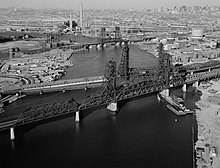
| 1.8 | Lincoln Highway Hackensack River Bridge
(Shawn Carson and Robert Nguyen Memorial Bridge) |

|
milepoint 1.72 Lincoln Highway East Coast Greenway |
40°43′38″N 74°05′55″W / 40.727324°N 74.098728°W | [23] | |
| Pulaski Skyway | 
|
40°44′06″N 74°05′42″W / 40.735064°N 74.09493°W | ||||
| PATH Lift Bridge | 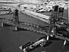
|
PRR and H&M PATH |
Jersey City & Kearny Meadows | 40°44′24″N 74°04′59″W / 40.740108°N 74.083048°W | ||
| Harsimus Branch Lift aka Hack Freight Railroad Bridge[24] |
|
PRR Conrail (North Jersey Shared Assets) NS |
40°44′26″N 74°04′55″W / 40.740475°N 74.082034°W | |||
| 3.1 | Wittpenn Bridge | 
|
original alignment of the Newark Turnpike |
40°44′25″N 74°04′52″W / 40.740313°N 74.081138°W | ||
| Wittpenn Bridge |

|
40°44′28″N 74°04′53″W / 40.741064°N 74.081266°W | ||||
| New Jersey Railroad (defunct) |

|
PRR | 40°44′28″N 74°04′53″W / 40.741064°N 74.081266°W | |||
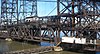
| 3.4 | Lower Hack Lift | 
|
DL&W Morris and Essex Lines (NJT) |
Riverbend | 40°44′36″N 74°04′37″W / 40.7432°N 74.0770°W | |
| 5.0 | Portal Bridge | 
|
PRR Northeast Corridor Amtrak and NJT |
Secaucus Junction & Kearny Meadows | 40°45′13″N 74°05′41″W / 40.75361°N 74.09472°W | |
| Portal Bridge South (planned) | Gateway Project | |||||
| Portal Bridge North (planned) | Gateway Project | |||||
| Lewandowski Hackensack River Bridge | 
|
Snake Hill & Kearny Meadows | 40°45′36″N 74°05′41″W / 40.760098°N 74.094594°W | |||
| DB Draw (unused) | 
|
New York and Greenwood Lake Railroad (Erie) Boonton Line (NJT) NS Essex–Hudson Greenway |
40°45′30″N 74°05′36″W / 40.75831°N 74.093355°W | |||
| 6.9 | Upper Hack Lift | 
|
DL&W Boonton Line (1959-1963) Erie/NJ Transit Main Line (NJT) Port Jervis Line (MNCR) MP 4.95 |
Harmon Cove & Kingsland | 40°46′41″N 74°05′24″W / 40.778015°N 74.089906°W | NJT #129 |
| Lackawanna Swing Bridge (defunct) | 
|
DL&W | ||||
| 7.7 | HX Draw aka The Jacknife |

|
Bergen County Line (NJT) Pascack Valley Line (NJT) Meadowlands Rail Line (NJT) Port Jervis Line (MNCR) former Erie Main LineMP 5.48 |
Harmon Cove & Meadowlands Sports Complex | 40°47′17″N 74°04′55″W / 40.788078°N 74.081869°W | NJT # |
| Route 3 East | 
|
Secaucus & Meadowlands Sports Complex | 40°47′55″N 74°04′08″W / 40.798745°N 74.068978°W | |||
| Route 3 West (Medgar Evers Bridge) |

|
40°48′02″N 74°04′01″W / 40.800678°N 74.067058°W | ||||
| Paterson Plank Road (defunct) | 
|
Jersey City, Hoboken and Rutherford Electric Railway Public Service |
Secaucus North End & Meadowlands Sports Complex |
40°48′21″N 74°03′39″W / 40.80586°N 74.0608°W | ||
| Western Spur Bridge | 
|
Carlstadt & Ridgefield Park | 40°49′23″N 74°02′04″W / 40.823179°N 74.034358°W | |||
| Bergen Turnpike (aka Hackensack Plank Road) (defunct) |
Public Service |
Ridgefield Park & Little Ferry | 40°50′55″N 74°01′49″W / 40.8485°N 74.0303°W | |||
| 14.0 | Route 46 Hackensack River Bridge (aka S46 Bridge & Winant Avenue Bridge) |

|
40°51′04″N 74°01′45″W / 40.8511°N 74.0293°W | |||
| Interstate 80 | 
|
Bogota & Hackensack | 40°52′02″N 74°02′08″W / 40.867104°N 74.035601°W | |||
| 16.3 | Court Street Bridge (Harold J. Dillard Memorial Bridge) |

|
Court Street - West Fort Lee Road | 40°52′44″N 74°02′22″W / 40.8790°N 74.0395°W | ||
| 16.2 | New York, Susquehanna and Western Railway | 
|
NYS&W[25] | 40°52′52″N 74°02′15″W / 40.881163°N 74.037393°W | ||
| Midtown Bridge aka Salem Street Bridge (Ryan Memorial Bridge)[26] |

|
West Main Street originally carried PS and predecessor streetcars lines |
40°52′57″N 74°02′10″W / 40.882509°N 74.036116°W | |||
| Anderson Street Bridge aka Cedar Lane Bridge |

|
East Anderson Street - Cedar Lane | Teaneck & Hackensack | 40°53′31″N 74°02′11″W / 40.891975°N 74.036288°W | ||
| Fairleigh Dickinson University Footbridge | 
|
40°53′56″N 74°01′54″W / 40.898812°N 74.031638°W | ||||
| Route 4 | 
|
40°54′09″N 74°01′48″W / 40.902582°N 74.030021°W | ||||
| Swing Bridge at New Bridge Landing Built 1889. to replace earlier 1744 sliding drawbridge. |
|
Main Street (no cars) | New Bridge Landing River Edge, Teaneck, New Milford |
40°54′46″N 74°01′56″W / 40.912816°N 74.032221°W | ||
| New Bridge Road | 
|
New Milford & River Edge | 40°54′54″N 74°01′50″W / 40.914907°N 74.030521°W | |||
| River Edge Avenue Bridge | 
|
40°56′06″N 74°01′43″W / 40.934914°N 74.028541°W | ||||
| New Milford Avenue Bridge (Merschrod Memorial Bridge) |

|
New Milford | 40°56′46″N 74°01′35″W / 40.946163°N 74.026505°W | |||
| Elm Street Bridge part of the New Milford Plant of the Hackensack Water Company |

|
Phoenix column Pratt pony truss | New Milford & Oradell | 40°56′49″N 74°1′30″W / 40.94694°N 74.02500°W | [27][28][29] | |
| Oradell Avenue Bridge | 
|
Oradell | 40°57′14″N 74°01′44″W / 40.953909°N 74.028933°W | [30] | ||
| Oradell Reservoir Dam | Oradell | 40°57′22″N 74°01′44″W / 40.956129°N 74.029001°W | ||||
| Old Hook Road Bridge | Emerson, Harrington Park & Closter | 40°58′37″N 73°59′03″W / 40.976889°N 73.984235°W | ||||
| Harriot Avenue Bridge | River Vale & Harrington Park | 40°59′06″N 73°59′30″W / 40.984976°N 73.991579°W | ||||
| Westwood Avenue Bridge | River Vale & Old Tappan New Jersey |
40°59′57″N 73°59′21″W / 40.999274°N 73.989304°W | ||||
| Old Tappan Road | 41°00′44″N 74°00′31″W / 41.012293°N 74.008504°W | |||||
| Lake Tappan Dam | footbridge | 41°01′06″N 74°00′04″W / 41.0183°N 74.0011°W | ||||
| Poplar Road – Washington Avenue | 41°01′07″N 73°59′59″W / 41.01855°N 73.99978°W | |||||
| Veterans Memorial Drive | New York State Pearl River |
41°02′39″N 73°59′17″W / 41.044145°N 73.98807°W | ||||
| Convent Road | Pearl River & Blauvelt | 41°03′16″N 73°58′56″W / 41.054534°N 73.982284°W | ||||
| Blauvelt Road | 41°03′38″N 73°59′09″W / 41.060537°N 73.985845°W | |||||
| Palisades Interstate Parkway | 41°03′57″N 73°58′44″W / 41.065892°N 73.978937°W | |||||
| Fifth Avenue | 41°04′13″N 73°58′32″W / 41.07024°N 73.97554°W | |||||
| Former Erie Railroad Bridge | ||||||
| Western Highway | West Nyack | 41°05′10″N 73°57′47″W / 41.086237°N 73.962923°W | ||||
| River Subdivision (CSX) | West Shore Railroad (NYC) River Line (Conrail) |
41°05′12″N 73°57′44″W / 41.086712°N 73.962341°W | ||||
| New York State Route 59 | 41°05′40″N 73°57′40″W / 41.094388°N 73.961045°W | |||||
| New York Thruway | West Nyack & Bardonia | 41°06′03″N 73°57′56″W / 41.100925°N 73.965501°W | ||||
| Old Mill Road | Bardonia | 41°06′20″N 73°58′00″W / 41.105468°N 73.966711°W | ||||
| Lake DeForest Dam | 41°06′22″N 73°58′01″W / 41.10621°N 73.966806°W | |||||
| Congers Road Causeway | New City & Congers | 41°09′21″N 73°57′30″W / 41.1558°N 73.9584°W | ||||
| Ridge Road | New City | 41°09′36″N 73°57′53″W / 41.1599°N 73.9648°W | ||||
| New York State Route 304 | 41°09′48″N 73°58′05″W / 41.1632°N 73.9681°W | |||||
| Haverstraw Road | Old Route 304 | 41°10′17″N 73°58′11″W / 41.17134°N 73.96984°W |

Abbreviations edit

- CNJ=Central Railroad of New Jersey
- CR=County Road, County Route
- CSXT=CSX Transportation
- DL&W=Delaware, Lackawanna and Western Railroad
- Erie=Erie Railroad
- H&M=Hudson and Manhattan Railroad
- MNCR=Metro-North Railroad
- MP=mile point
- NYC=New York Central Railroad
- NJDOT=New Jersey Department of Transportation
- NJT=New Jersey Transit
- NYS&W=New York, Susquehanna and Western Railway
- NS=Norfolk Southern Railway
- PATH=Port Authority Trans-Hudson
- PRR=Pennsylvania Railroad
- PS=Public Service Railway
- USGS=United States Geological Survey
See also edit
- New Milford Plant of the Hackensack Water Company
- Overpeck Creek
- Hackensack River Greenway
- Geography of New York–New Jersey Harbor Estuary
- Timeline of Jersey City, New Jersey-area railroads
- List of bridges, tunnels, and cuts in Hudson County, New Jersey
- List of crossings of the Lower Passaic River
- List of crossings of the Upper Passaic River
- List of NJ Transit moveable bridges
- List of fixed crossings of the North River (Hudson River)
 Transport portal
 Engineering portal
 New Jersey portal
 New York (state) portal
References edit
- ^ "The Bridges of Hudson County". March 26, 2021.
- ^ "Bridges are man-made marvels of the Hackensack River". North Jersey.com. July 15, 2010. Retrieved November 7, 2012.
- ^ "Hackensack River". The Travels of Tug 44. www.tug44.org. Retrieved November 7, 2012.
- ^ "The Hackensack River: A True Come-Back Story". Haceknsack Riverkeeper. Retrieved October 30, 2012.
- ^ Jeffs, Ed (April 2005). "A History of Lake Lucille & Vicinity". Retrieved November 1, 2012.
- ^ McKelvey, Bill. "Chronology: Transportation Milestones Around the CRR of NJ Jersey City Terminal (now Liberty State Park) and the NJ / NY Port Area". Liberty Historic Railway. Archived from the original on January 11, 2013. Retrieved November 1, 2012.
- ^ Snow, Violet (October 2, 2011). "Little Ferry 'tries to improve living' for residents". The Record (Bergen County). Retrieved October 10, 2012.
- ^ Howitt, Naomi; Howitt, george (1976), Musket, Anchor, and Plow: The Story of River Edge, 1677-1976, Arno Press, ISBN 0405098596
- ^ "Drawbridges and Railroad Operation" (PDF), The New York Times, May 1, 1903, retrieved October 31, 2012
- ^ a b Marshall, Stephen (December 2004). "The Meadowlands Before the Commission: Three Centuries of Human Use and Alteration of the Newark and Hackensack Meadows". 2 (1). Urban Habitats.
Dredging of the Hackensack River began in the 1900s, when the corps dug a 12-foot-deep channel. The current Hackensack River channel is 32 feet deep for the first 3 miles, 25 feet deep for the next ¼ mile, and 15 feet deep for an additional ½ mile. The channel varies between 800 and 200 feet in width
{{cite journal}}: Cite journal requires|journal=(help) - ^ Newark Bay/Hackensack River/Passaic River Study Area Report (PDF). Hudson-Raritan Estuary Environmental Restoration Feasibility (Report). United States Army Corps of Engineers. June 2004. Archived from the original (PDF) on July 31, 2010. Retrieved October 21, 2012.
- ^ "Ecology Along the Hackensack River" (PDF). Hackensack Water Works. Rutgers University School of Environmental and Biological Sciences Center for Urban Sustainability. August 2012. Archived from the original (PDF) on July 20, 2011. Retrieved November 1, 2012.
- ^ Newark Bay, Hackensack and Passaic Rivers – Hackensack River, New Jersey (PDF). Report of Channel Conditions 100 to 400 Feet Wide (ER 1130-2-306) (Report). April 18, 2011. Retrieved October 21, 2012.
- ^ Army Corps of Engineers. "Meadowlands Environmental Site Investigation Compilation". New Jersey Meadowlands Commission. Retrieved November 1, 2012.
- ^ Olsen, Kevin K. (2008), A Great Conveniency: A Maritime History of the Passaic River, Hackensack River, and Newark Bay, American History Imprints, ISBN 9780975366776
- ^ a b "117.723 Hackensack River", Title 33: Navigation and Navigable Waters Part 117—Drawbridge Operations Regulations, US Government Printing Office, October 20, 2012, archived from the original on December 27, 2014, retrieved October 20, 2012
- ^ Cichowksi, John (June 20, 2010), "Historic Bridge Getting Face-lift", The Record, retrieved October 20, 2012
- ^ Maag, Christopher (February 21, 2015). "When Bergen County sludge meets rusty Amtrak bridge, both sides lose". The Record.
- ^ Sheenan, Bill (Winter 2006). "The Truth About Traffic On the River". At the Helm: A Word from Captain Bill. Hackensack Riverkeeper. Archived from the original on November 7, 2011. Retrieved November 1, 2012.
- ^ "Drawbridge Schedules". NJDOT. April 12, 2012. Retrieved November 5, 2012.
- ^ "Overview". Route 7 Wittpenn Bridge. NJDOT. August 5, 2011. Retrieved November 6, 2012.
- ^ "Portal Bridge Capacity Enhancement Project" (Press release). NJDOT. Archived from the original on October 13, 2012. Retrieved November 1, 2012.
- ^ "U.S. Route 1-9 Truck straight line diagram" (PDF). NJDOT. Retrieved December 21, 2016.
- ^ 33CFR117.723(c)
- ^ "NYSW - Hackensack River Bridge (Old)".
- ^ bridgesnyc: Midtown Bridge (Hackensack and Bogota)
- ^ "Elm Street Bridge". Bridgehunter.com. Retrieved September 22, 2017.
- ^ "New Jersey and National Registers of Historic Places". New Jersey Department of Environmental Protection - Historic Preservation Office. Retrieved January 19, 2016.
- ^ Ryall, M. J.; Parke, J. E. Harding, G. A. R. (December 14, 2013). Bridge Management: Inspection, Maintenance, Assessment and Repair. Springer. ISBN 9781489972323.
{{cite book}}: CS1 maint: multiple names: authors list (link) - ^ Oradell Avenue, Bridge over Hackensack River (PDF). FY 2020 Study and Development Program (Report). North Jersey Transportation Planning Authority. 2019. Archived from the original (PDF) on October 20, 2020.
Bridge was constructed in 1904. The structure had a major reconstruction in 1970 and rehabilitated in 1995 with funding provided by NJDOT-LA. The bridge is structurally deficient and functionally obsolete. Superstructure is in poor condition due to section loss and deformed bottom flange plates as a result of the significant rust between the steel plates at midspan of the girders, holes in the bottom girder flanges, and section loss to the sidewalk cantilevered struts. The structure is classified as fracture critical. Oradell train station adjacent to bridge
Sources edit
- Olsen, Kevin K. (2008), A Great Conveniency: A Maritime History of the Passaic River, Hackensack River, and Newark Bay, American History Imprints, ISBN 9780975366776
- Richman, Steven M. (2005), The Bridges of New Jersey, Rutgers University Press, p. 135, ISBN 0813535107
- "Bridgesnyc".
- "Drawbridge Schedules". NJDOT. April 12, 2012.
- jag9889 (July 3, 2007). "Hackensack River Bridges". Flickr. Retrieved September 17, 2015.
{{cite web}}: CS1 maint: numeric names: authors list (link) - "Historic Bridge Survey (1991-1994)". NJDOT. 2001.
- "Masonry and Metal: The Historic Bridges of Bergen County, New Jersey" (PDF). Richard Grubb and Associates. 2008. Archived from the original (PDF) on July 10, 2012. Retrieved August 21, 2012.
This publication lists the wrong date for the swing bridge at New Bridge Landing. Correct date built is February 4, 1889.
- "National Bridge Inventory Database". Archived from the original on February 2, 2019. Retrieved October 26, 2012.
- Report of the Assembly Committee Appointed to Inquire into the Condition of the Bridges over the Passaic and Hackensack Rivers in the Counties of Union, Essex, Hudson (Report). Trenton: New Jersey Assembly. 1865.
- "117.723 Hackensack River", Title 33: Navigation and Navigable Waters Part 117—Drawbridge Operations Regulations, US Government Printing Office, October 20, 2012, archived from the original on December 27, 2014, retrieved October 26, 2012
External links edit
- Signals
- North Jersey.com: Bridges are man-made marvels of the Hackensack River
- United States Coast Pilot: Atlantic Coast. Cape Cod to Sandy Hook (U.S. Coast and Geodetic Survey) (Report). U.S. Government Printing Office. 1933.