


Summary
Jharkhand, a state of India, has twenty-four administrative districts.[1]

Administration edit
A district of an Indian state is an administrative geographical unit, headed by a district magistrate or a deputy commissioner, an officer belonging to the Indian Administrative Service. The district magistrate or the deputy commissioner is assisted by a number of officials belonging to different wings of the administrative services of the state.
A superintendent of Police, an officer belonging to Indian Police Service is entrusted with the responsibility of maintaining law and order and related issues.
History edit
At the time of formation, Jharkhand state had 18 districts. Later, six more districts were carved out by reorganizing these districts. The 23rd and 24th districts- Khunti and Ramgarh (carved out of erstwhile Ranchi and Hazaribagh District respectively) were made a district on 12 September 2007.
Administrative Divisions and District edit
There are 24 districts of Jharkhand, which are grouped in to 5 divisions. These divisions are:
- Palamu division - 3 Districts: Palamu, Garhwa, Latehar - Headquarters: Medininagar
- North Chotanagpur division - 7 Districts: Chatra, Hazaribagh, Koderma, Giridih, Ramgarh, Bokaro, Dhanbad - Headquarters: Hazaribagh
- South Chotanagpur division - 5 Districts: Lohardaga, Gumla, Simdega, Ranchi, Khunti - Headquarters: Ranchi
- Kolhan division - 3 Districts: West Singhbhum, Saraikela-Kharsawan, East Singhbhum - Headquarters: Chaibasa
- Santhal Pargana division - 6 Districts: Jamtara, Deoghar, Dumka, Pakur, Godda, Sahebganj - Headquarters: Dumka
Below is the list of districts:
| SI No. | Code | District | Headquarters | Area[2] (km2) | Population[2] (2011) | Population Density (/km2) | Map |
|---|---|---|---|---|---|---|---|
| 1 | BO | Bokaro | Bokaro Steel City | 2,883 | 2,062,330 | 715 | 
|
| 2 | CH | Chatra | Chatra | 3,718 | 1,042,886 | 280 | 
|
| 3 | DE | Deoghar | Deoghar | 2,477 | 1,492,073 | 602 | 
|
| 4 | DH | Dhanbad | Dhanbad | 2,040 | 2,684,487 | 1316 | 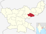
|
| 5 | DU | Dumka | Dumka | 3,761 | 1,321,442 | 351 | 
|
| 6 | ES | East Singhbhum | Jamshedpur | 3,562 | 2,293,919 | 644 | 
|
| 7 | GA | Garhwa | Garhwa | 4,093 | 1,322,784 | 323 | 
|
| 8 | GI | Giridih | Giridih | 4,962 | 2,445,474 | 493 | 
|
| 9 | GO | Godda | Godda | 2,266 | 1,313,551 | 580 | 
|
| 10 | GU | Gumla | Gumla | 5,360 | 1,025,213 | 191 | 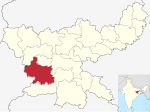
|
| 11 | HA | Hazaribagh | Hazaribagh | 3,555 | 1,734,495 | 488 | 
|
| 12 | Jamtara | Jamtara | 1,811 | 791,042 | 437 | 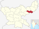
| |
| 13 | Khunti | Khunti | 2,535 | 531,885 | 210 | 
| |
| 14 | KO | Kodarma | Kodarma | 2,540 | 716,259 | 282 | 
|
| 15 | Latehar | Latehar | 4,291 | 726,978 | 169 | 
| |
| 16 | LO | Lohardaga | Lohardaga | 1,502 | 461,790 | 307 | 
|
| 17 | PK | Pakur | Pakur | 1,811 | 900,422 | 497 | 
|
| 18 | PL | Palamu | Medininagar | 4,393 | 1,939,869 | 442 | 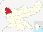
|
| 19 | Ramgarh | Ramgarh Cantonment | 1,341 | 949,443 | 708 | 
| |
| 20 | RA | Ranchi | Ranchi | 5,097 | 2,914,253 | 572 | 
|
| 21 | SA | Sahibganj | Sahibganj | 2,063 | 1,150,567 | 558 | 
|
| 22 | Saraikela-Kharsawan | Saraikela | 2,657 | 1,065,056 | 401 | 
| |
| 23 | Simdega | Simdega | 3,774 | 599,578 | 159 | 
| |
| 24 | WS | West Singhbhum | Chaibasa | 7,224 | 1,502,338 | 208 | 
|
See also edit
Notes and references edit
External links edit
 Jharkhand travel guide from Wikivoyage
- Travel guide to Jharkhand's districts
- Jharkhand State Government Official website