


Summary
The Indian state of Tamil Nadu is divided into 38 districts. Districts are the major administrative units of a state which are further sub-divided into taluks. There were 13 districts in the erstwhile Madras Province the boundaries of the present-day Tamil Nadu. Post the reorganization in 1956, Madras state had 13 re-organized districts which was further divided in the later years.
| Districts of Tamil Nadu | |
|---|---|
 Districts of Tamil Nadu | |
| Category | Districts |
| Location | Tamil Nadu |
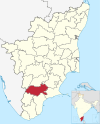
| Number | 38 districts |
| Populations | Perambalur – 565,223 (lowest); Chennai – 7,139,630 (highest) |
| Areas | Chennai – 426 km2 (164 sq mi) (smallest); Dindigul – 6,266.64 km2 (2,419.56 sq mi) (largest) |
| Government | |
| Subdivisions | |
History edit
Before 1947 edit
Before 1947, Madras Presidency under British Raj was made up of 26 districts, of which 12 districts were part of the boundaries of the present-day Tamil Nadu, namely, Chingleput, Coimbatore, Nilgiris, North Arcot, Madras, Madura, Ramnad, Salem, South Arcot, Tanjore, Tinnevely, and Trichinopoly.[1]
1947–56 edit

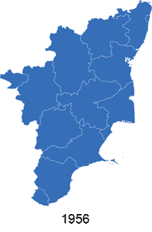
After Indian Independence, the Madras Presidency] became the Madras Province on 15 August 1947. Pudukottai, a princely state acceded to the Indian Union on 4 March 1948 and became a division in Trichinopoly district.[2] When the new constitution came into force on 26 January 1950, Madras Province became Madras State. Madras state included most of the present-day Tamil Nadu, Coastal Andhra and Rayalaseema of Andhra Pradesh, the Malabar region of Kerala, Bellary and South Canara districts of Karnataka.[3] Coastal Andhra and Rayalaseema were separated to form Andhra State in 1953.[4] As a result of the re-organization of states in 1956, South Canara and Bellary districts were merged with Mysore State to form Karnataka and Malabar district with the State of Travancore-Cochin to form Kerala in 1956.[5] The Tamil speaking regions of Kanyakumari which was earlier a part of Travancore-Cochin was merged to Madras state.[5] Madras state had 13 districts namely: Chingleput, Coimbatore, Kanyakumari, Madras, Madurai, Nilgiris, North Arcot, Ramanathapuram, Salem, South Arcot, Thanjavur, Tiruchirappalli and Tirunelveli.[6]
1957–89 edit
- On 2 October 1965, Dharmapuri district was bifurcated from the erstwhile Salem district comprising Dharmapuri, Harur, Hosur and Krishnagiri taluks.[7]
- In 1969, Madras State was renamed as Tamil Nadu.[8]
- On 14 January 1974, Pudukkottai district was formed from the parts of Tiruchirappalli] and Thanjavur districts comprising Kulathur, Thirumayam, Alangudi and Aranthangi taluks.[2]
- On 31 August 1979, Erode district was bifurcated from the erstwhile Coimbatore district comprising Gobichettipalayam and Erode taluks.[9]
- On 8 March 1985, Sivaganga and Virudhunagar districts were formed from the erstwhile Ramanathapuram district with Sivaganga comprising Tirupattur, Karaikudi, Devakottai, Sivaganga, Manamadurai and Ilayangudi taluks and Virudhunagar comprising Srivilliputhur, Virudhunagar, Tiruchuli, Aruppukottai, Sattur and Rajapalayam taluks.[10][11]
- On 15 September 1985, Dindigul district was bifurcated from the erstwhile Madurai district comprising Dindigul, Palani and Kodaikanal taluks.[12]
- On 20 October 1986, Thoothukudi district was bifurcated from the erstwhile Tirunelveli district comprising Thoothukudi, Ottapidaram and Tiruvaikuntam taluks.[13]
- On 30 September 1989, Tiruvannamalai and Vellore districts were formed from the erstwhile North Arcot district with Tiruvannamalai district comprising Tiruvannamalai, Arni, Vandavasi, Cheyyar, Polur and Chengam taluks[14] and Vellore district comprising Arakkonam, Arcot, Gudiyatham, Tirupattur, Vellore, Vaniyambadi and Walajapet taluks.[15]
1990–99 edit
- On 18 October 1991, Nagapattinam was bifurcated from the erstwhile Thanjavur district comprising Tiruvarur, Mayiladuthurai, Manargudi, Needamangalam, Nagapattinam taluks and Valangaiman from Kumbakonam taluk.[16]
- On 30 September 1993, Cuddalore and Viluppuram districts were formed from the erstwhile South Arcot district with Cuddalore district comprising Cuddalore, Chidambaram and Vriddachalam taluks and Villupuram district comprising Kallakuruchi, Villupuram, Tirukkoyilur and Tindivanam taluks.[17][18]
- On 30 September 1995, Karur and Perambalur districts were split from the erstwhile Tiruchirappalli district with Karur district comprising Karur, Kulithalai and Manapparai taluks and Perambalur district comprising Perambalur and Kunnam taluks.[19][20]
- On 25 July 1996, Theni district was bifurcated from the erstwhile Madurai district comprising Theni, Bodinayakanur, Periyakulam, Uthamapalayam and Andipatti taluks.[21]
- On 1 January 1997, Tiruvarur district was formed from the parts of erstwhile Nagapattinam and Thanjavur districts comprising Tiruvarur, Nannilam, Kudavasal, Needamangalam, Mannargudi, Thiruthiraipoondi taluks from Nagappatinam district and Valangaiman taluk from Thanjavur district.[22]
- On 1 January 1997, Namakkal district was bifurcated from the erstwhile Salem district comprising Namakkal, Tiruchengode, Rasipuram and Paramathi-Velur taluks.[23]
- On 1 July 1997, Kanchipuram and Tiruvallur districts were split from the erstwhile Chengalpattu and Chennai districts with Kanchipuram district comprising Kanchipuram, Sriperumbudur, Uthiramerur, Chengalpattu, Tambaram, Tirukalukundram, Maduranthakam and Cheyyur taluks and Tiruvallur district comprising Tiruvallur, Tiruttani, Ponneri and Gummidipoondi taluks.[24]
2000–present edit
- On 9 February 2004, Krishnagiri district was bifurcated from the erstwhile Dharmapuri district comprising Krishnagiri, Hosur, Pochampalli, Uthangarai and Denkanikottai taluks.[25]
- On 19 November 2007, Ariyalur district was bifurcated from the erstwhile Perambalur district comprising Ariyalur, Udayarpalayam and Sendurai taluks.[26]
- On 24 October 2009, Tiruppur district was formed from the parts of Coimbatore and Erode districts comprising Tiruppur, Udumalpet, Palladam and parts of Avinashi taluks of Coimbatore district and Dharapuram, Kangeyam and parts of Perundurai taluk of Erode district.[27]
- On 5 January 2018, the Chennai district was expanded by the addition of Madhavaram, Maduravoyal, Ambattur, Tiruvottriyur taluks and parts of Ponneri taluk of Tiruvallur district and Alandur and Sholinganallur taluks of Kanchipuram district.[28]
- On 22 November 2019, Tenkasi district was bifurcated from the erstwhile Tirunelveli district comprising Tenkasi, Sengottai, Kadayanallur, Sivagiri, Veerakeralampudur, Sankarankovil, Thiruvenkatam and Alangulam taluks.[29]
- On 26 November 2019, Kallakurichi district was bifurcated from the erstwhile Viluppuram district comprising Kallakurichi, Sankarapuram, Chinnasalem, Ulundurpet, Thirukovilur and Kalvarayanmalai taluks.[30]
- On 29 November 2019, Tirupattur and Ranipet districts were trifurcated from the erstwhile Vellore district with Tirupattur district comprising Tirupattur, Vaniyambadi, Natrampalli and Ambur taluks and Ranipet district comprising Walajah, Arcot, Nemili and Arakkonam taluks.[31]
- On 30 November 2019, Chengalpattu district was bifurcated from the erstwhile Kanchipuram district comprising Tirukalukundram], Chengalpattu, Madurantakam, Cheyyar, Tiruporur, Tambaram, Pallavaram and Vandalur taluks.[32]
- On 24 March 2020, Mayiladuthurai district was bifurcated from the erstwhile Nagapattinam district comprising Mayiladuthurai, Sirkazhi, Tharangambadi and Kuthalam taluks.[33]
List of districts edit
Active districts edit
No. District Code Headquarters Estd. Predecessor Area (km2)[34] Population[34] Pop.
density
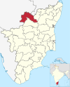
(/km2)Divisions[35] Taluks[35] Assembly constituencies Lok sabha constituencies Map 1 Ariyalur ARI Ariyalur 23 November 2007 Perambalur 2,027.6 754,894 372
- Andimadam
- Ariyalur
- Sendurai
- Udayarpalayam
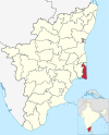
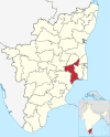
2 Chengalpattu CHG Chengalpattu 29 November 2019 Kanchipuram 2,802.6 2,556,244 912
- Chengalpattu
- Madurantakam
- Tambaram

3 Chennai
(formerly Madras)CHN Chennai 1 November 1956 None 462.3 46,46,732 10,052
- Chennai Central
- Chennai North
- Chennai South

4 Coimbatore COI Coimbatore 1 November 1956 None 4,950.7 3,458,045 699
- Coimbatore North
- Coimbatore South
- Pollachi

5 Cuddalore CUD Cuddalore 30 September 1993 South Arcot District 3,870 2,605,914 673
- Bhuvanagiri
- Chidambaram
- Cuddalore
- Kattumannarkoil
- Kurinjipadi
- Panruti
- Srimushnam
- Titakudi
- Veppur
- Vriddachalam

6 Dharmapuri DHA Dharmapuri 2 October 1965 Salem 4,735.7 1,506,843 318 
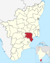
7 Dindigul DIN Dindigul 15 September 1985 Madurai 6,289.1 2,159,775 343
- Athoor
- Dindigul-East
- Dindigul-West
- Gujiliamparai
- Kodaikanal
- Natham
- Nilakottai
- Oddanchattiram
- Palani
- Vedasandur
8 Erode ERO Erode 31 August 1979 Coimbatore 6,036 2,251,744 373 
9 Kallakurichi KAL Kallakurichi 26 November 2019 Viluppuram 3,440.8 1,370,281 398
- Kallakkurichi
- Thirukoilur

10 Kancheepuram KAC Kancheepuram 1 July 1997 Chingleput 1,800.2 1,166,401 648
- Kancheepuram
- Sriperumbudur

11 Kanyakumari KAY Nagercoil 1 November 1956 None 1,729.2 1,870,374 1,082
- Agastheeswaram
- Kalkulam
- Killiyoor
- Vilavancode
- Thiruvattar
- Thovalai

12 Karur KAR Karur 30 September 1995 Tiruchirappalli 3,022.3 1,064,493 352
- Aravakurichi
- Kadavur
- Karur
- Krishnarayapuram
- Kulithalai
- Manmangalam
- Pugalur
13 Krishnagiri KRI Krishnagiri 9 February 2004 Dharmapuri 5,414.4 1,883,731 348
- Anchetty
- Bargur
- Denkanikottai
- Hosur
- Krishnagiri
- Pochampalli
- Shoolagiri
- Uthangarai
14 Madurai MAD Madurai 1 November 1956 None 3,846.4 3,038,252 790
- Madurai
- Melur
- Usilampatti
- Madurai-East
- Madurai-North
- Madurai-South
- Madurai-West
- Kallikudi
- Melur
- Peraiyur
- Thirumangalam
- Thirupparankundram
- Usilampatti
- Vadipatti

15 Mayiladuthurai MAY Mayiladuthurai 28 December 2020 Nagapattinam 1,237.1 918,356 742
- Mayiladuthurai
- Sirkazhi

16 Nagapattinam NAG Nagapattinam 18 October 1991 Thanjavur 1,459 697,069 478
- Nagapattinam
- Vedaranyam
17 Namakkal NAM Namakkal 1 January 1997 Salem 3,573.4 1,726,601 483
- Kollimalai
- Kumarapalayam
- Mohanur
- Namakkal
- Paramathi-Velur
- Rasipuram
- Senthamangalam
- Thiruchengode

18 Nilgiris NIL Ooty 1 November 1956 None 2,452.5 735,394 300 
19 Perambalur PER Perambalur 30 September 1995 Tiruchirappalli 1,836.6 565,223 308 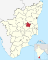
20 Pudukkottai PUD Pudukkottai 14 January 1974 Thanjavur and Tiruchirappalli 4,847.8 1,618,345 334
- Aranthangi
- Illuppur
- Pudukkottai
21 Ramanathapuram RAM Ramanathapuram 1 November 1956 None 4,243.1 1,353,445 319
- Kadaladi
- Kamuthi
- Kilakarai
- Mudukulathur
- Paramakudi
- Rajasingamangalam
- Ramanathapuram
- Rameswaram
- Tiruvadanai

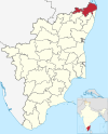
22 Ranipet RAN Ranipet 28 November 2019 Vellore 2,234.3 1,210,277 542
- Arakkonam
- Ranipet

23 Salem SAL Salem 1 November 1956 None 5,245 3,482,056 669 
24 Sivaganga SIV Sivaganga 15 March 1985 Ramanathapuram 4,086 1,339,101 328
- Devakottai
- Ilayangudi
- Kalayarkoil
- Karaikudi
- Manamadurai
- Singampunari
- Sivaganga
- Tirupathur
- Tiruppuvanam

25 Tenkasi TEN Tenkasi 22 November 2019 Tirunelveli 2,916.1 1,407,627 483
- Sankarankoil
- Tenkasi
- Alangulam
- Kadayanallur
- Sankarankoil
- Shenkottai
- Sivagiri
- Tenkasi
- Thiruvengadam
- Veerakeralampudur

26 Thanjavur THA Thanjavur 1 November 1956 None 3,396.6 2,405,890 708
- Budalur
- Kumbakonam
- Orathanadu
- Papanasam
- Pattukkottai
- Peravurani
- Thanjavur
- Thiruvaiyaru
- Thiruvidaimarudur
- Thiruvonam
27 Theni THE Theni 25 July 1996 Madurai 3,066 1,245,899 406 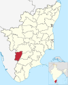
28 Thoothukudi THO Thoothukudi 20 October 1986 Tirunelveli 4,621 1,750,176 379 
29 Tiruchirappalli TIC Tiruchirappalli 1 November 1956 None 4,407 2,722,290 618 
30 Tirunelveli TIN Tirunelveli 1 November 1956 None 3842.4 1,665,253 433
- Ambasamudram
- Cheranmahadevi
- Manur
- Nanguneri
- Palayamkottai
- Radhapuram
- Tisayanvilai
- Tirunelveli

31 Tirupathur TIA Tirupattur 28 November 2019 Vellore 1,792.9 1,111,812 620
- Tirupathur
- Vaniyambadi
- Ambur
- Natrampalli
- Tirupathur
- Vaniyambadi

32 Tiruppur TIP Tiruppur 22 February 2009 Coimbatore and Erode 5,186.3 2,479,052 478
- Avinashi
- Dharapuram
- Kangeyam
- Madathukulam
- Palladam
- Tiruppur North
- Tiruppur South
- Udumalaipettai
- Uthukuli

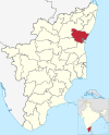
33 Tiruvallur TAL Tiruvallur 1 July 1997 Chingleput 3,444.2 3,728,104 1,082
- Avadi
- Gummidipoondi
- Pallipattu
- Ponneri
- Poonamallee
- R. K. Pettai
- Tiruttani
- Tiruvallur
- Uthukkottai
34 Tiruvannamalai TAN Tiruvannamalai 30 September 1989 North Arcot 6,191 2,464,875 398
- Aarani
- Cheyyar
- Tiruvannamalai
- Aarani
- Chengam
- Chetpet
- Cheyyar
- Jamunamarathur
- Kalasapakkam
- Kilpennathur
- Polur
- Thandarampattu
- Tiruvannamalai
- Vandavasi
- Vembakkam

35 Tiruvarur TAR Thiruvarur 18 October 1991 Thanjavur 2,161 1,264,277 585
- Koothanallur
- Kudavasal
- Mannargudi
- Nannilam
- Needamangalam
- Thiruthiraipoondi
- Tiruvarur
- Valangaiman
- Muthupet

36 Vellore VEL Vellore 30 September 1989 North Arcot 2,222.1 1,614,242 726
- Gudiyatham
- Vellore
- Anaicut
- Gudiyatham
- Pernampattu
- Katpadi
- Kilvaithinankuppam
- Vellore

37 Viluppuram VIL Viluppuram 30 September 1993 South Arcot 3,725.5 2,093,003 562
- Tindivanam
- Villupuram
- Gingee
- Kandachipuram
- Marakkanam
- Melmalaianur
- Tindivanam
- Vanur
- Vikravandi
- Villupuram
- Thiruvennainallur
38 Virudhunagar VIR Virudhunagar 15 March 1985 Ramanathapuram 4,288.0 1,942,288 453
- Aruppukkottai
- Sattur
- Sivakasi
- Aruppukkottai
- Kariapatti
- Rajapalayam
- Sattur
- Sivakasi
- Srivilliputhur
- Tiruchuli
- Virudhunagar
- Watrap
- Vembakottai


Former districts edit
| District | Span | Successor districts | Map |
|---|---|---|---|
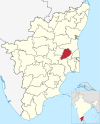
| Chingleput | 1956–98 | Kanchipuram, Chengalpattu and Tiruvallur | 
|
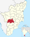
| North Arcot | 1956–89 | Tiruvannamalai, Vellore, Ranipet and Tirupattur | 
|
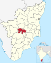
| South Arcot | 1956–93 | Cuddalore, Villupuram and Kallakurichi | 
|
See also edit
References edit
- ^ Cash, Benjamin (2007). Cholera Seasonality in Madras (1901–1940): Dual Role for Rainfall in Endemic and Epidemic Regions (Report). Ecohealth. doi:10.1007/s10393-006-0079-8. Retrieved 1 December 2023.
- ^ a b "History of Pudukottai". Government of Tamil Nadu. Retrieved 1 December 2023.
- ^ Abstract of 1951 census (PDF) (Report). Government of India. Retrieved 1 December 2023.
- ^ "Andhra State Act, 1953". Act of 14 September 1953 (PDF). Madras Legislative Assembly. Retrieved 1 December 2023.
- ^ a b "States Reorganisation Act, 1956". Act of 14 September 1953 (PDF). Parliament of India. Retrieved 1 December 2023.
- ^ 1961 census (PDF) (Report). Government of India. Retrieved 1 December 2023.
- ^ "Dharmapuri district". Government of Tamil Nadu. Retrieved 1 December 2023.
- ^ "Tracing the demand to rename Madras State as Tamil Nadu". The Hindu. 6 July 2023. Retrieved 1 December 2023.
- ^ "About Erode district". Government of Tamil Nadu. Archived from the original on 10 April 2019. Retrieved 1 December 2023.
- ^ "Sivganga district". Government of Tamil Nadu. Retrieved 1 December 2023.
- ^ "Virudhunagar district". Government of Tamil Nadu. Retrieved 1 December 2023.
- ^ "About Dindigul district". Government of Tamil Nadu. Archived from the original on 29 December 2019. Retrieved 1 December 2023.
- ^ "About Thoothukudi district". Government of Tamil Nadu. Archived from the original on 2 May 2019. Retrieved 1 December 2023.
- ^ "About Tiruvannamalai district". Government of Tamil Nadu. Archived from the original on 24 April 2019. Retrieved 1 December 2023.
- ^ "About Vellore district". Government of Tamil Nadu. Retrieved 1 December 2023.
- ^ "About Nagapattinam district". Government of Tamil Nadu. Retrieved 1 December 2023.
- ^ "About Cuddalore district". Government of Tamil Nadu. Archived from the original on 25 March 2020. Retrieved 1 December 2023.
- ^ "About Villupuram district". Government of Tamil Nadu. Retrieved 1 December 2023.
- ^ "About Karur district". Government of Tamil Nadu. Retrieved 1 December 2023.
- ^ "About Perambalur district". Government of Tamil Nadu. Retrieved 1 December 2023.
- ^ "About Theni district". Government of Tamil Nadu. Archived from the original on 27 April 2019. Retrieved 1 December 2023.
- ^ "About Tiruvarur district". Government of Tamil Nadu. Retrieved 28 April 2023.
- ^ "About Namakkal district". Government of Tamil Nadu. Retrieved 1 December 2023.
- ^ "About Tiruvallur district". Government of Tamil Nadu. Retrieved 1 December 2023.
- ^ "About Krishnagiri district". Government of Tamil Nadu. Archived from the original on 7 May 2019. Retrieved 1 December 2023.
- ^ "About Ariyalur district". Government of Tamil Nadu. Retrieved 1 December 2023.
- ^ "About Tiruppur district". Government of Tamil Nadu. Retrieved 1 December 2023.
- ^ "Expansion of Chennai district". The Times of India. 5 January 2018. Retrieved 1 December 2023.
- ^ "About Tenkasi district". The Hindu. 22 November 2019. Archived from the original on 14 November 2019. Retrieved 1 December 2023.
- ^ "About Kallakuruchi district". New Indian Express. 26 November 2019. Retrieved 1 December 2023.
- ^ "About Tirupattur and Ranipet districts". New Indian Express. 29 November 2019. Archived from the original on 24 December 2019. Retrieved 1 December 2023.
- ^ "About Chengalpattu district". The Hindu. 30 November 2019. Archived from the original on 21 March 2020. Retrieved 1 December 2023.
- ^ "About Mayiladuthurai district". The Hindu. 24 March 2020. Archived from the original on 25 April 2020. Retrieved 1 December 2023.
- ^ a b Districts of Tamil Nadu (Report). Government of Tamil Nadu. Retrieved 1 December 2023.
- ^ a b Government of Tamil Nadu–Taluks (PDF) (Report). Government of Tamil Nadu. Retrieved 1 April 2023.