


Summary
This is a list of earthquakes in Romania, including any notable historical earthquakes that have epicenters within the current boundaries of Romania, or which caused significant effects in this area.
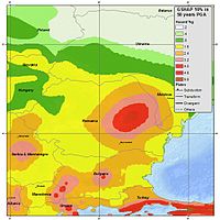 Seismic hazard for Romania from the Global Seismic Hazard Assessment Program (GSHAP) in terms of peak ground acceleration with a 10% chance of being exceeded (or a 90% chance of not being exceeded) within the next 50 years | |
| Largest | 7.9 Mw 1802 Vrancea earthquake |
|---|---|
| Deadliest | 7.2 Mw 1977 Vrancea earthquake 1,578 killed |
Seismic hazard edit
The seismicity of Romania is clustered in several epicentral zones: Vrancea, Făgăraș-Câmpulung, Banat, Crișana, Maramureș, and Southern Dobrogea.[1][2] Other epicentral zones of local importance can be found in Transylvania, in the area of Jibou and Târnava River, in the northern and western part of Oltenia, in northern Moldova, and the Wallachian Plain.[3] The Vrancea seismogenic zone is the most important among these seismic zones, having in mind the energy, the extent of the macroseismic effects, and the persistent and confined character of the earthquakes that occur in this area. The Vrancea area is responsible for over 90% of all earthquakes in Romania, releasing over 95% of the seismic energy.[4] Two belts of moderate and shallower seismicity are emphasized in the other regions of the country: one along the Southern Carpathians and the eastern edge of the Pannonian Basin, the other along the Eastern Carpathians that extends towards SE on the Peceneaga–Camena line.[5][6][7]
During the last 1,000 years, according to historical data, it is thought that 17 earthquakes of 7 and over magnitude have occurred, which suggests a means for unleashing the energy every 58 years. Statistically, the magnitude 6 and over earthquakes in the Vrancea area occur approximately every 10 years, with magnitude 7 every 33 years, while those with 7.5 magnitudes every 80 years.[8]
Earthquakes edit
Earthquakes listed in the following tables include only M6.0+ events or earthquakes with significant material damage or casualties. All seismic events are shown in detail in the ROMPLUS catalog of the National Institute for Earth Physics. It collected information from the catalog of Constantinescu and Mîrza (1980) for the period 984–1997. After 1997, the catalog was permanently filled and updated with data on seismic events produced in Romania and around national borders.
| Date | Epicenter | Mag. | Intensity | Deaths | Damage |
|---|---|---|---|---|---|
| 10 July 455 | It destroyed several towns and villages in Transylvania.[9] | ||||
| 543?–545? | 7.5 | Large tsunami on the Dobrujan shore of the Black Sea. The Roman fortress of Capidava, Constanța County, is destroyed.[10] | |||
| August 815 | Strong earthquakes, for five days, from the Balkans to the Carpathians, resulting in severe damage.[9] | ||||
| 6 July 1092 | Catastrophic earthquakes which last eight days. It causes huge losses in the Tisza area, also affecting Sătmar.[11] | ||||
| 25 January 1348 | Large earthquake in the Danube basin. 40 shocks in one day, strongly felt in Hungary, Italy, southern Germany, etc.[9] | ||||
| 5 June 1443 | Pannonian Plain | Parts of the Royal Palace, walls of the Citadel of Angevins and many other buildings in Temesvár collapse.[12] The St. Ladislau Cathedral in Várad is destroyed.[13] | |||
| 29 August 1471 | 7.1 | VIII–IX | The church of Neamț Monastery and the Neboisei Tower of Suceava Fortress are severely damaged.[14] In Brașov, a part of Mount Tâmpa slips over the city, and the citadel of Radu cel Frumos in Bucharest is reported in ruins. | ||
| 24 November 1516 | Vrancea County | Several houses destroyed and significant damage to surrounding wall of Brassó. Also felt in Suceava.[14] | |||
| 19 November 1523 | Mediaș, Sibiu County | 4.7 | VII | Light damage reported in Meggyes. The pillars of Evangelical Church in Sebeș collapse.[15] Album Oltardianum indicates 20 houses collapsed in Sibiu, while the Chronicle of Hutter reports many deaths among old population.[16] | |
| 26 October 1550 | 6.5 | VII–X | Large earthquake in southern Transylvania. | ||
| 10 August 1590 | 6.5 | VII–X | Large earthquake in southeastern Transylvania, with disastrous effects in Brașov, Râșnov, Sibiu and Mediaș. | ||
| 5 May 1603 | The strongest earthquake ever recorded inside the Carpathian arch. Also felt in Košice, Slovakia.[11] | ||||
| 8 November 1620 | Vrancea County | 6.9 | VIII–IX | ||
| 9 August 1679 | Vrancea County | 6.7 | VIII | ||
| 18 August 1681 | Vrancea County | 7.1 | VIII | The earthquake damages a dungeon in Suceava Fortress, in Moldavia. | |
| 11 June 1738 | Vrancea County | 7.7 | IX–X | Four mosques collapse in Nicopolis, the fortress of Niš, on the Serbian side of the Danube, reports significant damage. 11 monasteries, 15 houses, 15 towers and a church steeple collapse in Iași, while the walls and tower of the Prince's Court in Bucharest are destroyed.[17][18] | |
| 26 October 1802 | Vrancea County | 7.9–8.2 | IX | 4 | Chronicles and records of the Orthodox Church indicate extensive damage to churches and tall buildings in Bucharest. This is the strongest earthquake ever recorded in Romania, known by contemporary documents as "great earthquake of Good Friday". Felt on an area of 2 million km². Despite its intensity, only four people were killed. |
| 1 July 1829 | Ier Valley, Szatmár County | Significant damage in Carei and Satu Mare.[11] | |||
| 26 November 1829 | Vrancea County | 7.3[19] | VIII–IX | The earthquake occurs on Thursday morning, at 4 o'clock, causing great panic among population. In Bucharest, 150 stone houses are destroyed or severely damaged.[20] Felt over a very large area from Tisza to Bug and from Mureș to the Danube.[21] | |
| 23 January 1838 | Vrancea County | 7.5 | IX[22] | 73 | 73 deaths were recorded across the country, of which eight only in Bucharest.[23] In Wallachia, 217 churches collapsed or were severely damaged. A massive landslide barred the Bicaz River, forming the Red Lake.[24] |
| 13 November 1868 | Vrancea County | 6.4 | VII–VIII | ||
| 10 October 1879 | Moldova Nouă, Caraș-Severin County | 5.3 | VIII | The earthquake was followed by three aftershocks with magnitude over 4.1.[25] | |
| 3 October 1880 | Mihai Viteazu, Cluj County | 5.3 | VIII[16] | ||
| 31 August 1894 | Vrancea County | 7.1 | VIII | Occurred at 2:20 p.m. Underground noises reported in Panciu, Adjud and Focșani. | |
| 31 March 1901 | 7.2 | X | A 4 m high tsunami devastates localities on the shore of the Black Sea. Large landslides reported in Dobrich Province. Light damage to buildings in Bucharest.[26] | ||
| 6 February 1904 | Vrancea County | 6.6 | VI | ||
| 6 October 1908 | Vrancea County | 7.1 | VIII | The earthquake had three explosive moments at an interval of three minutes. The last phase generated "frightening jolts" and "formidable underground rumble". It damaged old houses in Bucharest, eastern Wallachia and southern Moldavia.[27] | |
| 25 May 1912 | Vrancea County | 6.7 | VII | ||
| 29 March 1934 | Vrancea County | 6.6 | VII | ||
| 10 November 1940 | Vrancea County | 7.7 | IX[28] | 1,000 | This was the strongest earthquake recorded in the 20th century in Romania. Its effects were devastating in central and southern Moldavia, but also in Wallachia. The death toll was estimated at 1,000, with an additional figure of 4,000 wounded, mostly in Moldavia.[29] The earthquake was felt in Bucharest, where there were about 300 deaths, mostly from the collapse of Carlton Bloc.[30] |
| 7 September 1945 | Vrancea County | 6.8 | VII–VIII | ||
| 9 December 1945 | Vrancea County | 6.5 | VII | ||
| 4 March 1977 | Vrancea County | 7.4 | VII–IX | 1,578 | 1,578 dead and 11,221 injured in Romania.[31] 120 dead and 165 injured in Bulgaria. Two dead in Moldova. Felt from Rome to Moscow and from Turkey to Finland.[32] A World Bank report indicates damage worthing US$2.048 billion.[33] |
| 30 August 1986 | Vrancea County | 7.1 | VIII | 150 | Officially, two dead and 558 injured.[34] In Chișinău, four apartment buildings collapsed, resulting in at least 100 casualties. In Bucharest, 50 workers were killed in the basement of a building, crushed by piles of rubble. The information was never confirmed. Over 50,000 houses were damaged.[35] |
| 30 May 1990 | Vrancea County | 6.9 | VIII | 14 | 14 dead and 362 injured.[36] Severe damage reported on large areas in Romania, Moldova and Bulgaria. Munich Re indicates economic losses of US$30 million.[37] |
| 31 May 1990 | Vrancea County | 6.4 | VII | This was the strongest aftershock of the 30 May mainshock. | |
| 12 July 1991 | Banloc, Timiș County | 5.7 | VIII | 2 | 5,000 rural buildings and a monumental church of German architecture are damaged.[38] 2 dead, 30 injured, hundreds to thousands displaced due to severe damage to buildings.[39] |
| 2 December 1991 | Voiteg, Timiș County | 5.6 | VIII | Some injured, serious damage in Voiteg (5,000 houses), 4,500 displaced.[38] | |
| 24 May 2002 | Caraș-Severin County | 4.7 | V | Five people were injured and some houses slightly damaged.[40] | |
| 27 October 2004 | Năruja, Vrancea County | 6.0 | Old buildings were slightly damaged. Blackouts were reported in epicentral area.[41] | ||
| 22 November 2014 | Panciu, Vrancea County | 5.7 | V | Cracks in walls and roads were reported in Galați and Tulcea.[42] Telephone network and power supply were disrupted in epicentral area. One man was injured in Tulcea. Eight people were injured in Galați[43] and five hypertensive people in Brăila needed medical care because of panic attacks.[44] | |
| 24 September 2016 | Vrancea County | 5.3 | VI | In Iași, a young man jumped out a window, suffering a fracture, and an old woman hurt herself in her house, while 12 people suffered panic attacks.[45] | |
| 28 October 2018 | Vrancea County | 5.8 | VI | In Bucharest, an old house was slightly damaged.[46] The Bucharest–Ilfov Ambulance Service registered 25 calls for panic attacks. Power supply was briefly disrupted in Întorsura Buzăului, close to the epicenter.[47] | |
| 31 January 2020 | Vrancea County | 5.2 | V | It happened at 03:26.[48] | |
| 3 November 2022 | Vrancea County | 5.4 | V | ||
| 13 February 2023[49] | Gorj County | 5.0 | VII | A foreshock of the 14 February Gorj earthquake. | |
| 14 February 2023[50] | Gorj County | 5.7 | VII | 22 localities affected in five counties – Gorj, Dolj, Hunedoara, Mehedinți and Vâlcea. Four people in Gorj injured by detached construction elements. 48 buildings slightly damaged in Târgu Jiu, close to the epicenter.[51] | |
| The inclusion criteria for adding events are based on WikiProject Earthquakes' notability guideline that was developed for stand alone articles. The principles described are also applicable to lists. In summary, only damaging, injurious, or deadly events should be recorded. | |||||
Gallery edit
-
 Turnul Colței heavily damaged by the 1802 Vrancea earthquake
 -
 Rescue operations at Carlton Bloc after the 1940 Vrancea earthquake
 -
 Enei Church was nearly destroyed during the 1977 Vrancea earthquake.
 -
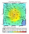
 USGS ShakeMap for the 1977 event.
 -
 USGS ShakeMap for the 1990 event.
 -
 USGS ShakeMap for the 2004 event.


See also edit
References edit
- ^ Lungu, D.; Aldea, A.; Arion, C. (2008). "Romania's Seismicity and Seismic Hazard: From Historical Records to Design Codes". Harmonization of Seismic Hazard in Vrancea Zone. NATO Science for Peace and Security Series C: Environmental Security. Springer. pp. 1–16. doi:10.1007/978-1-4020-9242-8_1. ISBN 978-1-4020-9242-8.
- ^ Sokolov, Vladimir Yu; Wenzel, Friedemann; Mohindra, Rakesh (2009), "Probabilistic seismic hazard assessment for Romania and sensitivity analysis: A case of joint consideration of intermediate-depth (Vrancea) and shallow (crustal) seismicity", Soil Dynamics and Earthquake Engineering, 29 (2): 364–381, Bibcode:2009SDEE...29..364S, doi:10.1016/j.soildyn.2008.04.004
- ^ Ardeleanu, L. et al. (2005) "Probabilistic seismic hazard map for Romania as a basis for a new building code". Natural Hazards and Earth System Sciences 5, 679–684
- ^ "Zona Vrancea este responsabilă de peste 90% din totalul cutremurelor produse în România". Agerpres (in Romanian). 9 October 2013.
- ^ Oncescu, M., Marza, V. I., Rizescu, M., and Popa, M. (1999). The Romanian earthquake catalogue between 984–1997, Vrancea Earthquakes: Tectonics, Hazard and Risk Mitigation (edited by F. Wenzel et al.), 43–47
- ^ Atanasiu I., 1961. Earthquakes in Romania. Academia R.P.R., Bucharest, 194pp. (in Romanian)
- ^ Radulian, M., Mândrescu, N., Panza, G.F., Popescu, E., Utale, A. (2000), Characterization of Seismogenic Zones of Romania, Pure appl. geophys. 157, 57–77
- ^ "Earthquake Risk Perception in Bucharest, Romania", Geological and Mining Engineering and Sciences
- ^ a b c Ștefănescu, Gr. (1901). Cutremurele de pămînt în România în timp de 1391 de anǐ: de la anul 455 până la 1846 (in Romanian). Bucharest: Carol Göbl Institute of Graphic Arts.
- ^ Florescu, Florea Bobu (1965). Das Siegesdenkmal von Adamklissi, Tropaeum Traiani (in German). Bucharest: Romanian People's Republic Academy.
- ^ a b c "Suntem pregătiți pentru a detecta un seism?". Buletin de Carei (in Romanian). 27 March 2011.
- ^ Florinesco, A. (1958). Catalogue des tremblements de terre ressentis sul le territoire de la R.P.R. (in French). Bucharest: Romanian People's Republic Academy.
- ^ Oros, Eugen (22 February 2012). "Seismicitatea, seismotectonica și hazardul seismic din zona Timișoara" (PDF). General Association of Engineers in Romania (in Romanian).
- ^ a b Rogozea, M.; Radulian, M.; Marmureanu, Gh.; Mandrescu, N.; Paulescu, D. (11 June 2012). Large and moderate historical earthquakes of 15th and 16th centuries in Romania reconsidered (PDF). Vol. 65. National Institute for Earth Physics. pp. 545–562.
- ^ Nussbächer, N. (1987). Din cronici și hrisoave. Contribuții la istoria Transilvaniei. Din cronica cutremurelor în Țara Bârsei (secolele XV–XX) (in Romanian). Kriterion. pp. 231–233.
- ^ a b Cornelius, Radu; Toro, Edith (5 October 1996). Two strong historical earthquakes in Transylvania (Romania): November 19, 1523 and October 3, 1880 (PDF). Vol. XXXIX. Annals of Geophysics. pp. 1069–1070.
- ^ "Scurt istoric al cutremurelor majore produse în România". Antena 3 (in Romanian). 26 April 2009.
- ^ Ursu, Ramona (4 March 2012). "Blestemele lui Dumnezeu asupra Capitalei: istoria cutremurelor care i-au îngrozit pe bucureșteni. Cum s-a refăcut orașul!". Adevărul (in Romanian).
- ^ Borcea, Ștefan (8 November 2013). "Istorie "zguduitoare": cele mai puternice cutremure care au înspăimântat România". Adevărul (in Romanian).
- ^ Borcea, Ștefan (18 March 2014). "Cutremurele de acum 200 de ani, pe limba martorilor evenimentelor. "Pământul pe alocurea s-au despicat și au eșit apă cu miros de iarbă de pușcă și de pucioasă"". Adevărul (in Romanian).
- ^ Rădulescu, Florin (2008–2009). Romanian seismology – Historical, scientific and human landmarks (PDF). Vol. 52–53. Bucharest: Rev. Roum. Géophysique. pp. 101–121.
- ^ Georgescu, Emil-Sever (1–6 August 2004). "Forensic engineering studies on historical earthquakes in Romania" (PDF). 13th World Conference on Earthquake Engineering. Vancouver.
- ^ Perrey, A. (1846). Mémoire sur les tremblements de terre dans le bassin du Danube (PDF) (in French). Lyon: Annales des sciences Phys. et Natur.
- ^ Rogozea, M.; Marmureanu, Gh.; Radulian, M.; Toma, D. (2014). Reevaluation of the macroseismic effects of the 23 January 1838 Vrancea earthquake (PDF). Vol. 66. pp. 520–538. Bibcode:2012EGUGA..14.8015R. Archived from the original (PDF) on 18 January 2022. Retrieved 3 February 2015.
{{cite book}}:|work=ignored (help) - ^ Stegărescu, Gabriela (23 December 2012). "Când a fost cel mai mare cutremur în Banat?". Timișoara Express (in Romanian).
- ^ Papadopoulos, G. A.; Diakogianni, G.; Fokaefs, A.; Ranguelov, B. (25 March 2011). "Tsunami hazard in the Black Sea and the Azov Sea: a new tsunami catalogue" (PDF). Natural Hazards and Earth System Sciences. 11 (3): 945. Bibcode:2011NHESS..11..945P. doi:10.5194/nhess-11-945-2011.
- ^ "Istoria cutremurelor din Vrancea și efectele din județul Prahova". Max-Media.ro (in Romanian). 21 November 2013. Archived from the original on 15 July 2014. Retrieved 11 June 2014.
- ^ Constantinescu, L.; Marza, V. I. (1980). A computer-compiled and computer-oriented cataloque of Romania's earthquakes during a millenium (984–1979). Rev. Roum. Geologie, Geophysique et Geographie. pp. 193–234.
- ^ E. S., Georgescu; A., Pomonis (15–16 November 2010). Human casualties due to the Vrancea, Romania earthquakes of 1940 and 1977: learning from past to prepare for future events. Mizunami: Mizunami International Symposium on Earthquake Casualties and Health Consequences.
- ^ Vlad, I.; Vlad, M. (12–17 October 2008). "Behavior of dwellings during strong earthquakes in Romania" (PDF). The 14th World Conference on Earthquake Engineering. Beijing.
- ^ Georgescu, Emil-Sever; Pomonis, Antonios (12–17 October 2008). "The Romanian earthquake of March 4, 1977, revisited: new insights into its territorial, economic and social impacts and their bearing on the preparedness for the future" (PDF). The 14th World Conference on Earthquake Engineering. Beijing.
- ^ "Significant Earthquakes of the World, 1977". U.S. Geological Survey. 14 January 2005.
- ^ Leeds, David J. (May 1977). Preliminary report of the March 4, 1977, Romania earthquake (PDF). Vol. 11. Earthquake Engineering Research Institute.
- ^ "Significant Earthquakes of the World, 1986". U.S. Geological Survey.
- ^ Monfret, Tony; Deschamps, Anne; Romanowicz, Barbara (April 1990). The Romanian Earthquake of August 30, 1986: A Study Based on GEOSCOPE Very Long-Period and Broadband Data (PDF). Vol. 133. Basel: Pure and Applied Geophysics. pp. 367–379.
- ^ Stoicu, Andrei (31 May 1990). "Radiojurnalul Zilei – 31 mai 1990". Jurnalul Național (in Romanian). Archived from the original on 3 February 2015. Retrieved 3 February 2015.
- ^ "Vrancea area". GEMECD. Archived from the original on 3 February 2015. Retrieved 3 February 2015.
- ^ a b Georgescu, Emil-Sever; Dobre, Daniela; Dragomir, Claudiu-Sorin; Borcia, Ioan Sorin. "Timișoara și seismele bănățene" (PDF). Roeduseis (in Romanian).
- ^ "Cum au trăit cei din Banloc cel mai mare cutremur din istoria Banatului: "A urlat pământul, am zis că vine sfârșitul lumii"". Adevărul (in Romanian). 16 March 2011.
- ^ "M 4.7 - 2 km ESE of Pojejena, Romania". earthquake.usgs.gov.
- ^ Baciu, Nicoleta (27 October 2014). "27 octombrie 2004 – Cel mai mare cutremur al ultimilor zece ani din România". Ziua de Constanța (in Romanian).
- ^ "Rețele de telefonie și curent picate, șosele crăpate, mobilă distrusă în apartamente – efectele cutremurului de 5,7 grade de sâmbătă seară". Gândul (in Romanian). 23 November 2014.
- ^ Romaniță, Maria (23 November 2014). "Panică după cutremur". Monitorul de Galați (in Romanian). Archived from the original on 4 February 2015. Retrieved 24 November 2014.
- ^ Coman, Florentin (24 November 2014). "Fără pagube materiale, dar cu multă panică". Obiectiv Vocea Brăilei (in Romanian). Archived from the original on 27 November 2014. Retrieved 24 November 2014.
- ^ "Cutremur puternic în România – s-a resimțit în București, Iași, Craiova". Ziare.com (in Romanian). 24 September 2016.
- ^ "Cutremur de 5,8 în România. Cel mai puternic seism din țară, din ultimii 14 ani, urmat de o replică". Digi24 (in Romanian). 28 October 2018.
- ^ "Cutremur de 5,8 în România, duminică. Seismul, resimțit în mai multe zone. Nu sunt înregistrate pagube și victime". Știrile Pro TV (in Romanian). 28 October 2018.
- ^ "5.2-magnitude earthquake in Romania felt in Bucharest". Romania Insider. 31 January 2020.
- ^ "M 5.0 - 0 km S of Dobrița, Romania". earthquake.usgs.gov. Retrieved 14 February 2023.
- ^ "M 5.5 - 2 km NW of Leleşti, Romania". earthquake.usgs.gov. Retrieved 14 February 2023.
- ^ "DSU: 22 de localităţi din cinci judeţe, afectate de cutremurul de marți din Gorj". Euronews România. 15 February 2023.
External links edit
- The National Institute for Research and Development for Earth Physics - NIEP
- Adevărul.ro – List of the most powerful earthquakes in Romania
- Cutremur.net – List of earthquakes in Romania since 1800
- Geodin.ro – Romanian seismology
- Realitatea.net – The five strongest earthquakes in Romania in the last 200 years
- National Institute for Earth Physics – List of earthquakes in Romania
- Seismic map of Bucharest