


Summary
This is a list of hills on the Isle of Wight. Many of these hills are important historical, archaeological and nature conservation sites, as well as popular hiking and tourist destinations on the Isle of Wight in southern England.
Colour key edit
| Class | Prominence |
|---|---|
| Marilyns | 150 – 599 m |
| HuMPs | 100 – 149 m |
| TuMPs | 30 – 99 m |
| Unclassified | 0 – 29 m |
The table is colour-coded based on the classification or "listing" of the hill. The types that occur on the Isle of Wight are Marilyns, HuMPs and TuMPs, listings based on topographical prominence. "Prominence" correlates strongly with the subjective significance of a summit. Peaks with low prominences are either subsidiary tops of a higher summit or relatively insignificant independent summits. Peaks with high prominences tend to be the highest points around and likely to have extraordinary views. A Marilyn is a hill with a prominence of at least 150 metres or about 500 feet.[1] A "HuMP" (the acronym comes from "Hundred Metre Prominence) is a hill with a prominence of at least 100 but less than 150 metres.[2] In this table Marilyns are in beige and HuMPs in lilac. A "TuMP" as defined here is a hill with a prominence of at least 30 but less than 100 metres. The term "sub-Marilyn" or "sub-HuMP" is used, e.g. in the online Database of British and Irish Hills to indicate hills that fall just below the threshold. To qualify for inclusion, hills must either be 100 metres or higher with a prominence of at least 30 metres, below 100 metres they must be in some way notable. For further information see the Lists of mountains and hills in the British Isles and the individual articles on Marilyns, HuMPs, and TuMPs. In this context, "TuMP" is used to connote a hill with a prominence of at least 30 but less than 100 metres. By way of contrast, see also the article listing Tumps (a traditional term meaning a hillock, mound, barrow or tumulus).
List of hills edit
| Hill | Height (m) | Prom. (m) | Grid ref. | Class | Parent | Range/Region | Remarks | Image |
|---|---|---|---|---|---|---|---|---|
| St Boniface Down[3] | 241 | 241 | SZ568785 | Marilyn, HuMP, TuMP, Isle of Wight county top (historical and current) | Southwest of the island. | Isle of Wight county top. Above steep cliffs dropping down to coastal village of Bonchurch |

| |
| St Catherine's Hill[3] | 239 | 127 | SZ493772 | HuMP, TuMP | St Boniface Down | Southern tip of the island. | Isle of Wight's second highest hill. Tumulus 35 metres south of trig point. |

|
| Appuldurcombe Down[3] | 226 | 91 | SZ536796 | TuMP, sub-HuMP | St Boniface Down | Southwest of the island. | Very flat summit area. | 
|
| Brighstone Down[3] | 214 | 150 | SZ432847 | Marilyn, HuMP, TuMP | St Boniface Down | West of the island. | Trig point at summit. | 
|
| Harboro[3] | 203 | 78 | SZ406847 | TuMP | Brighstone Down | West of the island. | Tumulus at summit. | 
|
| Chillerton Down[3] | 167 | 61 | SZ475834 | TuMP | Brighstone Down | West of the island. | Summit 2m from trig point which is in a depression. | 
|
| Brook Down[3] | 164 | 69 | SZ390852 | TuMP | Brighstone Down | West of the island. | Barrows and tumulus near summit. | 
|
| Whitwell Hill[3] | 158 | 45 | SZ520766 (est.) | TuMP | St Boniface Down | South of the island. | Open downland above the coast. | |
| Chillerton Down South Top[3] | 148 | 35 | SZ475826 | HuMP, TuMP, sub-Marilyn | Brighstone Down | West of the island. | No summit feature; 20 metres ENE of Tennyson's Monument. | |
| Tennyson Down[3] | 147 | 145 | SZ475826 | HuMP, TuMP, sub-Marilyn | Brighstone Down | Southwest of the island. | No summit feature; ground on fenceline. | 
|
| West High Down[3] | 141 | 30 | SZ306849 | TuMP | Brighstone Down | Western tip of the island. | Summit 1 metre E of marker stone. | 
|
| Grammar's Common[3] | 137 | 35 | SZ415837 (est.) | TuMP | Brighstone Down | Southwest of the island. | Wooded summit. | |
| Arreton Down[3] | 135 | 108 | SZ526840 | HuMP, TuMP | Brighstone Down | East of centre of the island. | Trig point at summit. | 
|
| Berry Hill[3] | 134 | 35 | SZ484827 | TuMP | Brighstone Down | Southwest centre of the island. | No summit feature; ground on fenceline. | |
| Brading Down[3] | 131 | 58 | SZ585869 | TuMP | St Boniface Down | East of the island. | Obvious grassy summit. In the vicinity are the site of a Roman villa, field systems, a vineyard, the Devil's Punch Bowl and Nunwell House | 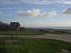
|
| Ashey Down[3] | 130 | 32 | SZ574875 | TuMP | St Boniface Down | East of the island. | Open summit on south side of obelisk (sea mark. Nearby tumuli. | 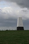
|
| Headon Hill[3] | 120 | 34 | SZ312858 | TuMP | Brighstone Down | Western tip of the island. | Open summit above steep hillside overlooking Totland Bay. | 
|
| Bembridge Down[3] | 104 | 101 | SZ625860 | HuMP, TuMP | St Boniface Down | Eastern coast of the island. | Bembridge Fort at summit. Nearby road and car park. Overlooking Sandown Bay. | 
|
| Golden Hill[3] | 52 | 34 | SZ339878 | TuMP | Brighstone Down | Western end of the island. | Golden Hill Fort at the summit, which is on circular bank around former fortress. | 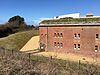
|
See also edit
References and footnotes edit
- ^ Dawson, Alan (1992). The Relative Hills of Britain. Milnthorpe: Cicerone Press. ISBN 1-85284-068-4. Archived from the original on 21 September 2010.
- ^ Jackson, Mark (2009). More Relative Hills of Britain, Marilyn News Centre, UK.
- ^ a b c d e f g h i j k l m n o p q r s Name, height, prominence, grid and class data from Database of British and Irish Hills at www.hill-bagging.co.uk, retrieved 27 Dec 2016. Also parent data unless otherwise stated.