


Summary
This is a list of irredentist claims or disputes. Irredentism is any political or popular movement that seeks to claim or reclaim and occupy a land that the movement's members consider to be a "lost" (or "unredeemed") territory from their nation's past. Not all territorial disputes are irredentist, although they are often couched in irredentist rhetoric to justify and legitimise such claims both internationally and within the country. What is and is not considered an irredentist claim is sometimes contentious.
Current governmental irredentist claims edit
Argentina edit

Argentina has claimed land that used to be part of, or was associated with, the Spanish territory of the Viceroyalty of the Rio de la Plata. The viceroyalty began to dissolve into separate independent states in the early 19th century, one of which later became Argentina.[1] The claims included, amongst other areas, parts of what in 2019 were Chile, Paraguay, Brazil, Uruguay, and Bolivia. Some of these claims have been settled, although others are still active. The active claims include part of the land border with Chile, a section of the Antarctic continent, and the British South Atlantic islands, including the Falklands.[2]
Argentina renews these claims periodically.[3] It considers the Falkland archipelago to be part of the Tierra del Fuego Province, along with South Georgia and the South Sandwich Islands. Its claim is included in the transitional provisions of the Constitution of Argentina as amended in 1994:[4][5]
The Argentine Nation ratifies its legitimate and non-prescribing sovereignty over the Malvinas, Georgias del Sur and Sandwich del Sur Islands and over the corresponding maritime and insular zones, as they are an integral part of the National territory. The recovery of these territories and the full exercise of sovereignty, respecting the way of life for its inhabitants and according to the principles of international law, constitute a permanent and unwavering goal of the Argentine people.
Bolivia edit

The 2009 constitution of Bolivia states that the country has an "unrenounceable right over the territory that gives it access to the Pacific Ocean and its maritime space".[6] Bolivia and Peru ceded land to Chile after the War of the Pacific, which left Bolivia as a landlocked country. The lost Atacama region is a source of conflict in the two countries' relations.[7][8] Every year, Bolivians celebrate the Día del Mar (Day of the Sea) in observance of the lost territories.[9]
China (PRC) edit
The preamble to the Constitution of the People's Republic of China states, "Taiwan is part of the sacred territory of the People's Republic of China (PRC). It is the lofty duty of the entire Chinese people, including our compatriots in Taiwan, to accomplish the great task of reunifying the motherland." The PRC's claim to sovereignty over Taiwan is generally based on the theory of the succession of states, with the PRC claiming that it is the successor state to the Republic of China (ROC).[10]
However, the People's Republic of China (PRC) has never controlled Taiwan.[11] The ROC government formerly administered both mainland China and Taiwan but has been administering primarily Taiwan only, since the Chinese Civil War in which it fought the People's Liberation Army of the Chinese Communist Party. While the official name of the state remains the 'Republic of China', the country is commonly called 'Taiwan', as Taiwan makes up 99% of the controlled territory of the ROC.
China (ROC) edit
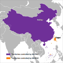
The Qing dynasty of China ceded Taiwan and the Penghu Islands to the Empire of Japan in perpetuity in the Treaty of Shimonoseki in 1895, along with the Liaodong Peninsula.[12] The Republic of Formosa was a short-lived republic[13][14] that then existed on the island of Taiwan for about five months in 1895 in the period between the formal cession of Taiwan to the Empire of Japan and de facto Japanese occupation and control. Japan then established a colony on Taiwan that existed until control of Taiwan was ceded to the Nationalist Government of the Republic of China in 1945.[15]
Article 4 of the Constitution of the Republic of China originally stated that "[t]he territory of the Republic of China within its existing national boundaries shall not be altered except by a resolution of the National Assembly". The National Assembly was de facto abolished in 2005, whose power was inherited by the Legislative Yuan. The Legislative Yuan holds the power to decide a referendum regarding changes to the ROC territory. Throughout the 1950s and 1960s, the Government of the Republic of China on Taiwan actively maintained itself to be the legitimate ruler of the entirety of China, including both mainland China, Taiwan, Tibet and Outer Mongolia. As part of its current policy of maintaining the 'status quo', the ROC has not renounced claims over the territories currently controlled by the PRC, Mongolia, India, Russia, Myanmar, Pakistan, Bhutan, North Korea and some Central Asian states. However, the ROC does not actively pursue these claims in practice; the remaining claims that the ROC is actively seeking are of uninhabited islands: the Senkaku Islands, whose sovereignty is also asserted by Japan and is part of Ishigaki, Okinawa. As far as the Paracel Islands and Spratly Islands in the South China Sea are concerned, the Philippines, Malaysia, Brunei, and Vietnam have repeatedly claimed sovereignty over some or most of these islands, rejecting the Chinese claimed "Nine-dash line".
Comoros edit
Article 1 of the Constitution of the Union of the Comoros begins: "The Union of the Comoros is a republic, composed of the autonomous islands of Mohéli, Mayotte, Anjouan, and Grande Comore." Mayotte, geographically a part of the Comoro Islands, was the only island of the four to vote against independence from France (independence losing 37%–63%) in the referendum held December 22, 1974. Mayotte is currently a department of the French Republic.[16][17]
Guatemala edit
Guatemala has claimed Belize in whole or in part since 1821.
India, Pakistan and China edit

Kashmir, a mountainous region spanning the northernmost tip of the Indian subcontinent, has been the subject of a territorial dispute between India and Pakistan since the partition of India in August 1947. In the face of a Pakistani invasion, the Kashmiri king Hari Singh signed the Instrument of Accession with India, bringing the country into a direct state of conflict with Pakistan in what would become the Indo-Pakistani War of 1947–1948. Since then, the two countries have fought multiple wars over the issue, but neither side has managed to capture and control the entire region. China became involved in the conflict in 1962, after consolidating control over what had been Indian-administered territory in Kashmir during the Sino-Indian War.
In practice, the zones of control in Kashmir remain divided into three disputed parts, with India and Pakistan separated by the Line of Control and India and China separated by the Line of Actual Control. India claims the entire region on the basis of the Instrument of Accession signed with Kashmir's king in 1947; Pakistan claims only the Indian-controlled parts of Kashmir, having signed the Sino-Pakistan Agreement in 1963; and Chinese claims are limited to parts of Indian-controlled territory, not including areas claimed by Pakistan. The official government maps of these countries generally accommodate these territorial claims by including the appropriate disputed lands within their borders.
Israel and Palestine edit
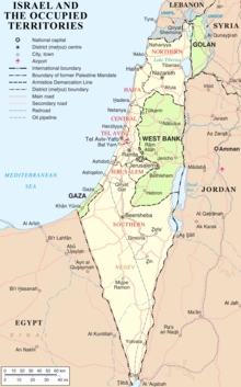
In November 1947, the United Nations Partition Plan for Palestine was adopted with 72% in-favour votes, aiming to split the territory of the region into a Jewish state and an Arab state. However, this plan was never implemented—the Israeli Declaration of Independence had been rejected by the Arab League and ultimately led to the 1948 Palestine war. This war led to the emergence of three zones of control: Israel, an independent Jewish state; the West Bank, annexed by Jordan; and the Gaza Strip, occupied by Egypt. Israel's founding ideology, the Zionist movement, had claimed the territory as the Jewish homeland; these claims are based on the Jews' ancestral habitation and periodic sovereignty in the land as well as the cultural/religious significance of that region as expressed in the Hebrew Bible. The latter is particularly relevant to the Israeli claim to Jerusalem—Israel controlled only half of the city (West Jerusalem) after its independence, with the other half (East Jerusalem) coming under Jordanian control.
In a historical or religious context, many Jews commonly refer to the West Bank as Judea and Samaria (the biblical terms), which formed a large part of the ancient Kingdom of Israel. Following the outbreak of the Six-Day War in 1967, Israel captured the Jordanian-annexed West Bank and the Egyptian-occupied Gaza Strip, in addition to the Syrian Golan Heights and the Egyptian Sinai Peninsula. Since 1967, Israeli settlements have been established throughout these Israeli-occupied territories, which are regarded as having historical and religious significance to the Jewish people and strategic significance to the Israeli state. Israel withdrew from Gaza in 2005, but the Israeli occupation of the West Bank continues, though the Israeli government has never explicitly claimed sovereignty over any part of that territory apart from East Jerusalem, which it effectively annexed in 1967. The Israeli settlements in the West Bank and the Golan Heights, which were unilaterally annexed by Israel in 1981, are usually supported by the Israeli government and protected by the Israeli military, drawing condemnation from the international community as an obstacle to the Israeli–Palestinian peace process. Though the Gazan Israeli settlements were dismantled in 2005, Israel is still regarded as an occupying power over the Gaza Strip under international law and will remain accountable for the territory until the Egyptian–Israeli blockade of Gaza is lifted.
In 1980, Israel passed the Jerusalem Law, which declares "Jerusalem, complete and united" as the capital city of Israel, formalizing the 1967 effective annexation. Article 3 of the Basic Law of the Palestinian Authority, which was ratified in 2002 and which serves as an interim Palestinian constitution, declares that "Jerusalem is the capital of Palestine" despite the fact that the Palestinian Authority administers from Ramallah and specific "Areas" of the West Bank that were specified by the Oslo Accords. Since 2007, Hamas has administered the Gaza Strip, further isolating it from the West Bank and splitting the Palestinian territories between two separate governments. The Palestinian Authority claims the West Bank and the Gaza Strip (the "1967 borders") as the territory for an independent Palestinian state; Hamas, which does not recognize Israeli sovereignty, claims the entirety of the former British Mandate as the territory for an independent Palestinian state.
Since 1967, there has been support among right-wing Israelis for a potential Israeli annexation of the West Bank. The territory of Jordan has also been subject to irredentist claims by hardline Israelis and Palestinians, with the former seeing it as part of a "Greater Israel" and the latter seeing it as part of a "Greater Palestine"; the country bordered the British Mandate as a British protectorate, known as the Emirate of Transjordan, until achieving independence in 1946. Jordan claimed sovereignty over the West Bank between 1950 and 1988, when this claim was renounced in light of the upcoming Israel–Jordan peace treaty.
Japan edit
Japan claims the four southernmost islands of the Russian-administered Kuril Islands, the island chain north of Hokkaido, annexed by the Soviet Union following World War II with the treaty of San Francisco. Japan also claims the South Korean-administered Liancourt Rocks, which are known as Dokdo in Korea and as Takeshima in Japan and have been claimed since the end of the Second World War.
Philippines edit
The Philippines claim portions of North Borneo as part of its territory, which is administered as part of Malaysia's Sabah state. The Philippines' irredentist claim is based on the disputed territory being formerly administered by the Sultanate of Sulu.[18][19]
Russia edit
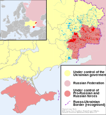
Russia promotes a claim on the territory of Ukraine, a place which Russian President Vladimir Putin describes as "essentially the same historical and spiritual space."[20] This claim has also been explicitly described as "irredentist" by American commentators.[21]
Russia also promotes claims to various post-Soviet states and militarily supports several breakaway polities in eastern Ukraine, eastern Moldova and northern Georgia.[22]
- Ukraine (see 2014 pro-Russian unrest in Ukraine, All-Russian nation and 2022 Russian invasion of Ukraine)
- Crimea (see Annexation of Crimea by the Russian Federation, Autonomous Republic of Crimea, 2003 Tuzla Island conflict)
- Donbas (see 2022 Russian invasion of Ukraine)
- Donetsk People's Republic (see 2022 Russian invasion of Ukraine, International recognition of the Donetsk People's Republic and the Luhansk People's Republic) – illegally annexed by Russia in October 2022
- Luhansk People's Republic (see 2022 Russian invasion of Ukraine, International recognition of the Donetsk People's Republic and the Luhansk People's Republic) – illegally annexed by Russia in October 2022
- Belarus (see All-Russian nation)
- Moldova
- Georgia
Spain edit
Spain maintains a claim on Gibraltar, a British Overseas Territory near the southernmost tip of the Iberian Peninsula, which has been British since the 18th Century.
Gibraltar was captured in 1704, during the War of the Spanish Succession (1701–1714). The Kingdom of Spain formally ceded the territory in perpetuity to the British Crown in 1713, under Article X of the Treaty of Utrecht. Spain's territorial claim was formally reasserted by the Spanish dictator Francisco Franco in the 1960s and has been continued by successive Spanish governments. In 2002 an agreement in principle on joint sovereignty over Gibraltar between the governments of the United Kingdom and Spain was decisively rejected in a referendum. The British Government now refuses to discuss sovereignty without the consent of the Gibraltarians.[23]
Major non-governmental irredentist claims edit

Albania edit
Greater Albania[24] or Ethnic Albania as called by the Albanian nationalists themselves,[25] is an irredentist concept of lands outside the borders of Albania which are considered part of a greater national homeland by most Albanians,[26] based on claims on the present-day or historical presence of Albanian populations in those areas. The term incorporates claims to all of Kosovo, as well as territories in the neighbouring countries Montenegro, Greece, Serbia and North Macedonia. According to the Gallup Balkan Monitor 2010 report, the idea of a Greater Albania was supported by the majority of Albanians in Albania (63%), Kosovo (81%) and North Macedonia (53%).[26][27]
In 2012, as part of the celebrations for the 100th Anniversary of the Independence of Albania, Prime Minister Sali Berisha spoke of "Albanian lands" stretching from Preveza in Greece to Preševo in Serbia, and from the Macedonian capital of Skopje to the Montenegrin capital of Podgorica, angering Albania's neighbours. The comments were also inscribed on a parchment that will be displayed at a museum in the city of Vlore, where the country's independence from the Ottoman Empire was declared in 1912.[28]
Armenia edit

The concept of a United Armenia (classical Armenian: Միացեալ Հայաստան, reformed: Միացյալ Հայաստան, translit. Miatsyal Hayastan) refers to areas within the traditional Armenian homeland—the Armenian Highland—which are currently or have historically been mostly populated by Armenians. This incorporates claims to Western Armenia (eastern Turkey), Nagorno-Karabakh (Artsakh), the landlocked exclave Nakhchivan of Azerbaijan and the Javakheti (Javakhk) region of Georgia.[29] Nagorno-Karabakh and Javakhk are overwhelmingly inhabited by Armenians. Western Armenia and Nakhchivan had significant Armenian populations in the early 20th century, but no longer do. The Armenian population of eastern Turkey was almost completely exterminated during the genocide of 1915, when the millennia-long Armenian presence in the area largely ended and Armenian cultural heritage was largely destroyed by the Turkish government.[30][31] The territorial claims to Turkey are often seen as the ultimate goal of the recognition of the Armenian genocide and the hypothetical reparations of the genocide.[32][33]
Basque Country edit

Basque irredentism refers to the idea of uniting the Basque Country (greater region) into one single state. This movement claims the territories of Basque Country (autonomous community), Navarre and parts of Nouvelle-Aquitaine
Ireland edit

The Irish Free State achieved partial independence with a dominion status under the British Empire in 1922. This state did not include Northern Ireland, which comprised six counties in the north-east of the island of Ireland which remained in the United Kingdom. When the Constitution of Ireland was adopted in 1937 it provided that the name of the state is Ireland; this is considered the time that the Republic of Ireland became a full-fledged independent nation. In the constitution Articles 2 and 3 provided that "[t]he national territory consists of the whole island of Ireland", while stipulating that "[p]ending the re-integration of the national territory", the powers of the state were restricted to legislate only for the area which had formed part of the Irish Free State. Arising from the Northern Ireland peace process, the matter was mutually resolved as part of the Good Friday Agreement in 1998. Ireland's constitution was altered by referendum and its territorial claim to Northern Ireland was removed.
The amended constitution asserts that while it is the entitlement of "every person born in the island of Ireland … to be part of the Irish Nation" and to hold Irish citizenship, "a united Ireland shall be brought about only by peaceful means with the consent of a majority of the people, democratically expressed, in both jurisdictions in the island". A North/South Ministerial Council was created between the two jurisdictions and given executive authority. The advisory and consultative role of the government of Ireland in the government of Northern Ireland granted by the United Kingdom, that had begun with the 1985 Anglo-Irish Agreement, was maintained, although that Agreement itself was ended. The two states also settled the long-running dispute concerning their respective names: Ireland and the United Kingdom of Great Britain and Northern Ireland, with both governments agreeing to use those names.
Under the Irish republican theory of legitimism, the Irish Republic declared in 1916 was in existence from then on, denying the legitimacy of either the state of Ireland or the position of Northern Ireland within the United Kingdom. Through much of its history, this was the position of Sinn Féin; however, it effectively abandoned this stance after accepting the Good Friday Agreement. Small groups which split from Sinn Féin continue to adopt this stance, including Republican Sinn Féin, linked with the Continuity IRA, and the 32 County Sovereignty Movement, linked with the Real IRA.
Historical irredentist claims edit
Africa edit
Some Ethiopian nationalist circles claim the former Ethiopian province of Eritrea (internationally recognized as the independent State of Eritrea in 1993 after a 30-year civil war).
Horn of Africa edit
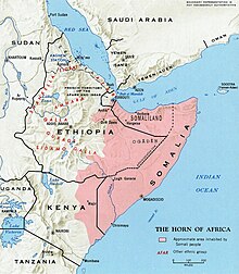
Greater Somalia refers to the region in the Horn of Africa in which ethnic Somalis are and have historically represented the predominant population. The territory encompasses Somalia, Somaliland, the Somali region in Ethiopia, the North Eastern Province in Kenya and southern and eastern Djibouti. Ogaden in eastern Ethiopia has seen military and civic movements seeking to make it part of Somalia. This culminated in the 1977–78 Ogaden War between the two neighbours where the Somali military offensive between July 1977 and March 1978 over the disputed Ethiopian region Ogaden ended when the Somali Armed Forces retreated back across the border and a truce was declared. The Kenyan Northern Frontier District also saw conflict during the Shifta War (1963–1967) when a secessionist conflict in which ethnic Somalis in the Lamu, Garissa, Wajir and Mandera counties (all except Lamu formed part of the former North Eastern Province, abolished in 2013), attempted to join with their fellow Somalis in a "Greater Somalia". There has been no similar conflicts in Djibouti, which was previously known as the "French Somaliland" during colonisation. Here the apparent struggles for unification manifested itself in political strife that ended when in a referendum to join France as opposed to the Somali Republic succeeded among rumours of widespread vote rigging.[34] and the subsequent death of Somali nationalist Mahmoud Harbi, Vice President of the Government Council, who was killed in a plane crash two years later under suspicious circumstances.[35] Some sources say that Somalia has also laid a claim to the Socotra archipelago, which is currently recognized by the international community as part of Yemen, but occupied by the United Arab Emirates[36]
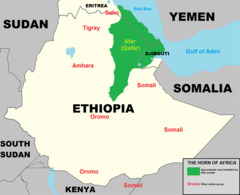
Afar homeland refers to a creation of a homeland[37] for the Afar people encompassing the Afar Region of Ethiopia, the Southern Red Sea Region of Eritrea and parts of Djibouti
North Africa edit
In North Africa, the prime examples of irredentism are the concepts of Greater Morocco and Greater Mauritania.[38] While Mauritania has since relinquished any claims to territories outside its internationally recognized borders, Morocco continues to claim Western Sahara, which it refers to as its "Southern Provinces".
Southern Africa edit
Greater Eswatini includes much of the Mpumalanga Province of South Africa.[39] King Mswati III of Eswatini set up the Border Restoration Committee in 2013 to negotiate restoration of the original borders.[40]
Asia edit
Assyria edit
The Assyrian homeland is a geographic and cultural region situated in Northern Mesopotamia that has been traditionally inhabited by Assyrian people. The area with the greatest concentration of Assyrians on earth is located in the Assyrian homeland, or the Assyrian Triangle, a region which comprises the Nineveh Plains, southern Hakkari and the Barwari regions.[41] This is where some Assyrian groups seek to create an independent nation state.[42] The land roughly mirrors the boundaries of ancient Assyria proper, and the later Achaemenid, Seleucid, Parthian, Roman and Sassanid provinces of Assyria (Athura/Assuristan) that was extant between the 25th century BC and 7th century AD.[43]
Azerbaijan edit
Whole Azerbaijan is an irredentist concept of uniting presumed historically Azerbaijani-inhabited territories into Republic of Azerbaijan. Western Azerbaijan is an irredentist political concept that is used in Azerbaijan mostly to refer to Armenia. Azerbaijani statements claim that the territory of the modern Armenian republic were lands that once belonged to Azerbaijanis.[44]
Bangladesh edit
Greater Bangladesh is an assumption of several Indian intellectuals that the neighbouring country of Bangladesh has an aspiration to unite all Bengali dominated regions under their flag. These include the states of West Bengal, Tripura and Assam as well as the Andaman Islands which are currently part of India and the Burmese State of Rakhine. The theory is principally based on a widespread belief amongst Indian masses that a large number of illegal Bangladeshi immigrants reside in Indian territory. It is alleged that illegal immigration to India is actively encouraged by some political groups in Bangladesh as well as the Government of Bangladesh to convert large parts of India's northeastern states and West Bengal into Muslim-majority areas that would subsequently seek to separate from India and join Muslim-majority Bangladesh.[citation needed]
Caucasus edit
Irredentism is acute in the Caucasus region. The Nagorno-Karabakh movement's original slogan of miatsum ('union') was explicitly oriented towards re-unification with Armenia as to the pre-Soviet status, feeding an Azerbaijani understanding of the conflict as a bilateral one between itself and an irredentist Armenia.[45][46][47][48][49] According to Prof. Thomas Ambrosio, "Armenia's successful irredentist project in the Nagorno-Karabakh region of Azerbaijan" and "From 1992 to the cease-fire in 1994, Armenia encountered a highly permissive or tolerant international environment that allowed its annexation of some 15 percent of Azerbaijani territory".[50]
In the view of Nadia Milanova, Nagorno-Karabakh represents a combination of separatism and irredentism.[51] However, the area has historically been Armenian, known as the Kingdom of Artsakh or Khachen. In July 1920, the 11th Soviet Red Army invaded and occupied the region and on July 28, the decision to make Nakhchivan a part of modern-day Azerbaijan was cemented on March 16, 1921, in the Treaty of Moscow between Soviet Russia and the newly founded Republic of Turkey.[52] Azerbaijan's irredentism, on the other hand, is quite explicit in official statements of the Azerbaijani officials by claiming the UN member-state Armenia as Azerbaijani territory despite the absence of historical evidence of Azerbaijan existing as a separate state up until 1918. On his official meeting in Gyanja on January 21, 2014, President Ilham Aliyev said, "The present-day Armenia is actually located on historical lands of Azerbaijan. Therefore, we will return to all our historical lands in the future. This should be known to young people and children. We must live, we live and we will continue to live with this idea."[53]
China edit
When Hong Kong and Macau were British and Portuguese territories, respectively, China considered these two territories to be Chinese territories under British and Portuguese administration. Therefore, Hong Kong people and Macau people descended from Chinese immigrants were entitled to Hong Kong Special Administrative Region passport or Macao Special Administrative Region passport after the two territories became special administrative regions. Similar claims are made by China on Arunachal Pradesh and Ladakh as part of Tibet, Mongolia, South China Sea, etc.[54]
India edit

The call for creation of Akhand Bharat or Akhand Hindustan has on occasion been raised by some Indian right wing Hindutvadi cultural and political organisations, such as the Hindu Mahasabha, Rashtriya Swayamsevak Sangh (RSS), Vishwa Hindu Parishad, Bharatiya Janata Party (BJP).[55][56][57][58] The name of one organisation sharing this goal, the Akhand Hindustan Morcha, bears the term in its name.[59] Other major Indian non-sectarian political parties, such as the Indian National Congress, maintain a position against the partition of India .
There has been many armed irredentist movements in the region active for almost a century. Most prominent amongst them are the Naga fight for Greater Nagaland, the Chin struggle for a unified Chinland, the Sri Lankan Tamil struggle for a return of their state under Tamil Eelam and other self-determinist movements by the ethnic indigenous peoples of the erstwhile Assam both under the British and post-British Assam under India.[60] Other such movements include Beḻagāva border dispute on Maharashtra and Karnataka border with intentions to unite all Marathi speaking people under one state since the formation of the Karnataka state and dissolution of the bilingual Bombay state.
Indonesia edit

Indonesia claimed all territories of the former Dutch East Indies, and previously viewed British plans to group the British Malaya and Borneo into a new independent federation of Malaysia as a threat to its objective to create a united state called Greater Indonesia. The Indonesian opposition of Malaysian formation has led to the Indonesia–Malaysia confrontation in the early 1960s. It also held Portuguese Timor (modern East Timor) from 1975 to 2002 based on irredentist claims.
The idea of uniting former British and Dutch colonial possessions in Southeast Asia actually has its roots in the early 20th century, as the concept of Greater Malay (Melayu Raya) was coined in British Malaya espoused by students and graduates of Sultan Idris Training College for Malay Teachers in the late 1920s.[61] Some political figures in Indonesia including Mohammad Yamin and Sukarno revived the idea in the 1950s and named the political union concept as Greater Indonesia.
Iran edit
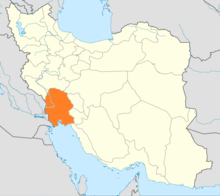
Pan-Iranism is an ideology that advocates solidarity and reunification of Iranian peoples living in the Iranian plateau and other regions that have significant Iranian cultural influence, including the Persians, Azerbaijanis, Ossetians, Kurds, Zazas, Tajiks of Tajikistan and Afghanistan, the Pashtuns and the Baloch of Pakistan. The first theoretician was Dr Mahmoud Afshar Yazdi.[63][64][65][66][67][68]
The ideology of pan-Iranism is most often used in conjunction with the idea of forming a Greater Iran, which refers to the regions of the Caucasus, West Asia, Central Asia, and parts of South Asia that have significant Iranian cultural influence due to having been either long historically ruled by the various Iranian (Persian) empires (such as those of the Medes, Achaemenids, Parthians, Sassanians, Samanids, Timurids, Safavids, and Afsharids and the Qajar Empire),[69][70][71] having considerable aspects of Persian culture in their own culture due to extensive contact with the various Empires based in Persia (e.g., those regions and peoples in the North Caucasus that were not under direct Iranian rule), or are simply nowadays still inhabited by a significant amount of Iranic-speaking people who patronize their respective cultures (as it goes for the western parts of South Asia, Bahrain and China). It roughly corresponds to the territory on the Iranian plateau and its bordering plains.[72][73] It is also referred to as Greater Persia,[74][75][76] while the Encyclopædia Iranica uses the term Iranian Cultural Continent.[77]
Iraq edit


After gaining independence in 1932, the Kingdom of Iraq immediately declared that the Sheikhdom of Kuwait was rightfully a territory of Iraq, claiming it had been part of an Iraqi territory until being created by the British.[79]
The Iraqi Republic under Abd al-Karim Qasim held an irredentist claim to Khuzestan.[80] It also held irredentist claims to Kuwait.[81]
Saddam Hussein's government sought to annex several territories. In the Iran–Iraq War, Ba'athist Iraq claimed it had the right to hold sovereignty to the east bank of the Shatt al-Arab river held by Iran.[62] Iraq had officially agreed to a compromise to hold the border at the centre-line of the river in the 1975 Algiers Agreement in return for Pahlavi Iran to end its support for Kurdish rebels in Iraq.[62] The overthrow of Mohammad Reza Pahlavi and the rise of Ruhollah Khomeini to power in the 1979 Iranian Revolution deteriorated Iran–Iraq relations and following ethnic clashes within Khuzestan and border clashes between Iranian and Iraqi forces, Iraq regarded the Algiers Agreement as nullified and abrogated it and a few days later the Iraqi Armed Forces launched a full-scale invasion of Iran that resulted in the Iran-Iraq War.[62] In addition, Saddam supported the Iraq-based Ahwaz Liberation Movement and their goal of breaking their claimed territory of Ahwaz away from Iran, in the belief that the movement would rouse Khuzestan's Arabs to support the Iraqi invasion.[82] In the Gulf War, Iraq occupied and annexed Kuwait before being expelled by an international military coalition that supported the restoration of Kuwait's sovereignty.
After annexing Kuwait, Iraqi forces amassed on the border with Saudi Arabia, with foreign intelligence services suspected that Saddam was preparing for an invasion of Saudi Arabia to capture or attack its oil fields that were a very short distance from the border.[83] It has been suspected that Saddam Hussein intended to invade and annex a portion of Saudi Arabia's Eastern Province on the justification that the Saudi region of Al-Hasa had been part of the Ottoman province of Basra that the British had helped Saudi Arabia conquer in 1913.[84] It is believed that Saddam intended to annex Kuwait and the Al-Hasa oil region, so that Iraq would be in control of the Persian Gulf region's vast oil production, that would make Iraq the dominant power in the Middle East.[85] The Saudi Arabian government was alarmed by Iraq's mobilization of ten heavily armed and well-supplied Iraqi Army divisions along the border of Iraqi-annexed Kuwait and Saudi Arabia, and warned the United States government that they believed that Iraq was preparing for an immediate invasion of Saudi Arabia's Eastern Province.[86] The Saudi Arabian government stated that without assistance from outside forces, Iraq could invade and seize control of the entire Eastern Province within six hours.[86]
Israel edit
Greater Israel is an expression that has held several different biblical and political meanings over time. It is often used, in an irredentist fashion, to refer to the historic or desired borders of Israel. Currently, the most common definition of the land encompassed by the term is the territory of the State of Israel together with the Palestinian territories. An earlier definition, favored by Revisionist Zionism, included the territory of the former Emirate of Transjordan.
Korea edit
The 1909 Gando Convention addressed a territory dispute between Qing China and Joseon Korea in China's favor. Because the convention was made by the occupying Empire of Japan, it was de jure nullified after the Surrender of Japan and North Korea started to control the area south of Paektu Mountain.
In 1961, the People's Republic of China published a map nominally claiming a boundary passing dozens of kilometers south of Paekdu Mountain.[87] North Korea protested this by publishing a national map with claims on Gando.[88] While neither of these claims was seriously enforced, the area between the Gando Convention line and Paektu Mountain were still in dispute. In 1963, North Korea signed a boundary treaty with the People's Republic of China, which settled the boundary between the two at the Yalu/Amnok (Chinese/Korean names) and Tumen Rivers; this agreement primarily stipulated that three-fifths of Heaven Lake at the peak of Mt. Baekdu would go to North Korea, and two-fifths to China.[89]
In 1990, the Soviet Union and North Korea signed a border treaty recognizing Noktundo island, an island of historical significance in Joseon military history involving Admiral Yi Sun-sin, as a part of the Soviet Union and later Russia. South Korea does not recognize the treaty and maintains the nation's claim on the island administered by Russia.[90]
While South Korea did not recognize this agreement, they made no serious attempts to gain Korean sovereignty on Gando. South Korea did not officially renounce their claim on Gando, but the Sino-Korean boundary on South Korean national map loosely follows the 1961 line except Mt. Baekdu, accepting the boundary on the map as the de facto boundary.
Some Koreans who maintain an irredentist claim on Gando regard Gando as Korean territory and the 1963 treaty as null and void. More ambitious claims include all parts of Manchuria that the Goguryeo kingdom controlled.
Lebanon edit
The Lebanese nationalism incorporates irredentist views seeking to unify all the lands of ancient Phoenicia around present day Lebanon.[91] This comes from the fact that present day Lebanon, the Mediterranean coast of Syria, and northern Israel is the area that roughly corresponds to ancient Phoenicia and as a result the majority of the Lebanese people identify with the ancient Phoenician population of that region.[92] The proposed Greater Lebanese country includes Lebanon, Mediterranean coast of Syria, and Northern Israel.
Mongolia edit
The irredentist idea that advocates cultural and political solidarity of Mongols. The proposed territory usually includes the independent state of Mongolia, the Chinese regions of Inner Mongolia (Southern Mongolia) and Dzungaria (in Xinjiang), and the Russian subjects of Buryatia. Sometimes Tuva and the Altai Republic are included as well.
Nepal edit
Greater Nepal involves the incorporation of the territories won by the Kingdom of Nepal at its greatest extent back to the Federal Democratic Republic of Nepal.
Pakistan edit
Pakistani irredentism involves the incorporation of India, Afghanistan, Bangladesh, and parts of Burma under Pakistan. This is most notable in the conflict in the Jammu and Kashmir a state divided between Pakistan and India.
Syria edit
The Syrian Social Nationalist Party, which operates in Lebanon and Syria, works for the unification of most modern states of the Levant and beyond in a single state referred to as Greater Syria.[93] The proposed Syrian country includes Lebanon, Israel, Syria, Jordan, and parts of Turkey, and has at times been expanded to include Iraq, Cyprus, and the Sinai peninsula.
Thailand edit

Thailand allied with the axis powers in the 1940s in an attempt to "reclaim all of the former Thai lands." This was part of the Pan-Thai movement. The map depicts the occupation and annexation of the Cambodian territory (Nakhon Champassak, Phibunsongkhram, and Phra Tabong), Shan territory (Saharat Thai Doem), Laos territory (Lan Chang) and Malay territory (Si Rat Malai).[citation needed]
Turkey edit
Misak-ı Millî is the set of six important decisions made by the last term of the Ottoman Parliament. Parliament met on 28 January 1920 and published their decisions on 12 February 1920. These decisions worried the occupying Allies, resulting in the de jure Occupation of Constantinople by the British, French and Italian troops on 16 March 1920 and the establishment of a new Turkish nationalist parliament, the Grand National Assembly, in Ankara.
The Ottoman Minister of Internal Affairs, Damat Ferid Pasha, made the opening speech of parliament due to Mehmed VI's illness. A group of parliamentarians called Felâh-ı Vatan was established by Mustafa Kemal's friends to acknowledge the decisions taken at the Erzurum Congress and the Sivas Congress. Mustafa Kemal said "It is the nation's iron fist that writes the Nation's Oath which is the main principle of our independence to the annals of history." Decisions taken by this parliament were used as the basis for the new Turkish Republic's claims in the Treaty of Lausanne.[citation needed]
United Arab Emirates edit
The Greater and Lesser Tunbs as well as Abu Musa are disputed by the United Arab Emirates with Iran.
Yemen edit

Greater Yemen is a theory giving Yemen claim to former territories that were held by various predecessor states that existed between the Himyarite period and 18th century. The areas claimed include parts of modern Saudi Arabia and Oman.
Europe edit
Bosnia and Herzegovina edit

Bosniak irredentism often endorses the annexation of the region of Sandžak, where a Bosniak community lives[94]
Bulgaria edit

Based on territorial definitions according Bulgarian ethnicity, also the territories of the historical Bulgarian national state – the Bulgarian Empire, a Greater Bulgaria nationalist movement has been active for more than a century, aiming to annex the rest of the three national core regions – Moesia, Thrace and Macedonia.
Catalonia edit
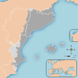
Catalan countries refers to the idea of creating an independent Catalan country encompassing Catalonia, Balearic Islands, Valencian Community, La Franja, Andorra, Carche, Alghero and Roussillon
Croatia edit

Finland edit

Greater Finland was an irredentist and nationalist idea which emphasized the territorial expansion of Finland. The most common concept of Greater Finland saw the country as defined by natural borders encompassing the territories inhabited by Finns and Karelians, ranging from the White Sea to Lake Onega and along the Svir River and Neva River—or, more modestly, the Sestra River—to the Gulf of Finland. Some proponents also included the Torne Valley (in Sweden), Ingria, and Estonia.
Former Yugoslavia edit
Some of the most violent irredentist conflicts of recent times in Europe flared up as a consequence of the break-up of the former federal state of Yugoslavia in the early 1990s.[dubious ][clarification needed] One of the last conflicts erupted further south with the ethnic Albanian majority in Kosovo seeking to switch allegiance to the adjoining state of Albania.[95]
France edit

The natural borders of France (French: Frontières naturelles de la France) were a nationalist theory developed in France, notably during the French Revolution. They correspond to the Rhine, the Atlantic Ocean and Mediterranean Sea, the Pyrenees and the Alps, according to the revolutionaries.
Germany edit


During the debate of what was then called the German Question (die deutsche Frage) in the 19th century prior to the unification of Germany (1871), the term Großdeutschland, "Greater Germany", referred to a possible German nation consisting of the states that later comprised the German Empire and Austria. The term Kleindeutschland "Lesser Germany" referred to a possible German state without Austria. The term was later used by Germans referring to Greater Germany, a state consisting of pre–World War I Germany, Austria and the Sudetenland.
Since the foundation of the German Reich in 1871, the only times during which German governments did not make some form of explicit or implicit irredentist demand or claim - including the demand for reunification during German partition - were prior to World War I and following German reunification.
The Weimar Republic contained significant irredentist elements which frequently formed part of the governing coalitions.[96] The Treaty of Locarno settled Germany's western boundaries (accepting among others the definitive loss of Alsace-Lorraine) but regarding the eastern boundaries with Czechoslovakia and the Second Polish Republic it only contained a provision that any revision of borders would occur non-violently. There was never a renunciation on the part of the German government prior to World War II of any claim to territory to the east of its internationally recognized borders.[97] The foreign ministers of Germany and France who are credited with the success of the treaty negotiations, Aristide Briand and Gustav Stresemann, were awarded the Nobel Peace Prize for their efforts.[98] The Territory of the Saar Basin was put under a League of Nations mandate but was de facto a French protectorate. In 1935 (two years after Hitler had been appointed chancellor) a previously agreed to referendum was held, transferring sovereignty over the Saar Area to Germany. The reference to "1937 borders" (de:Deutsches Reich in den Grenzen vom 31. Dezember 1937) was used after the war to allow for the inclusion of the Saar Area into this concept of "Germany" while at the same time excluding the territorial developments of 1938 and early 1939 (see below), which were widely seen as the illegitimate result of German aggression and Anglo-French appeasement after the war.
A main point of Nazi ideology was to reunify all Germans either born or living outside of Germany to create an "all-German Reich". These beliefs ultimately resulted in the Munich Agreement, which ceded to Germany areas of Czechoslovakia that were mainly inhabited by Sudeten Germans, and the Anschluss, which ceded the entire country of Austria to Germany; both events occurred in 1938. Later (but still prior to the outbreak of general war in Europe) the Protectorate of Bohemia and Moravia was formed which included a Czech ethnic majority and a German speaking minority among other ethnic groups. Among the Origins of World War II in Europe was the German irredentist demand to the Polish corridor an ethnically diverse but predominantly Polish area that separated East Prussia from the rest of Germany and was the only access to the sea for the Second Polish Republic. Another point of contention in the interwar German-Polish relationship was the status of the Free City of Danzig which had an ethnic German majority population but had become a League of Nations backed City State following World War I due to its strategic importance.

During German partition both states initially claimed their intention was an eventual German reunification, but East Germany eventually abandoned this claim. The German Basic Law contained both an exhortation towards reunification[99] and a provision (Article 23) concerning the "joining of other German areas" to the area of validity of the Basic Law.[100] Article 23 was struck from the Basic Law in the course of reunification and has since been replaced with an unrelated provision concerning the European Union.[101] The German Democratic Republic was relatively quick to officially endorse the Oder Neisse line as its new eastern border, signing the Treaty of Zgorzelec in 1950. However, there remained irredentist sentiment regarding territory east of the new border among the populous of both German states. Most of the West German public and political class refused to accept the loss of the eastern territories in the early years of the postwar era as evidenced by a list of potential car license plates for cities in the GDR, in areas lost due to World War II and even in areas like the former Free City of Danzig. The government of Willy Brandt (governed 1969-1974) made efforts to de facto recognize the postwar status quo in exchange for political rapprochement in the course of Ostpolitik, accepting among other things the entry of both East and West Germany into the United Nations in 1973. Willy Brandt was awarded a Nobel Peace Prize for his reconciliation efforts. However, the slim majority his social-liberal coalition had won in the 1969 German federal election had dwindled by 1972 because several members of the Social Democratic Party and the Free Democratic Party had switched parties due to their disagreement with Ostpolitik. After surprisingly surviving the 1972 constructive vote of no confidence, the government was reelected in a landslide in the 1972 German federal election which was held a year early in light of events. While the CDU/CSU government of Helmut Kohl which came into office in 1982 did not reverse Ostpolitik, the treaties accepting the postwar borders had been carefully worded so as to preserve the option of some different "final settlement" in the course of a peace treaty or following a possible German reunification. Thus the question of German claims to territory outside the two German states became acute again in the course of the negotiations that ultimately led to the Treaty on the Final Settlement with Respect to Germany or "two plus four agreement" and the final official renunciation of all German claims to any territory beyond the borders it achieved on October 3, 1990. Since then irredentist claims have been limited to a tiny far right minority and have had no major influence on national politics. However, in the course of the Kaliningrad question there were negotiations between Germany and Russia as to whether sovereignty should be transferred to Germany.[102][103][104]
Greece edit
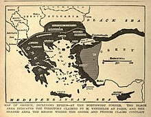
Following the Greek War of Independence in 1821–1832, Greece began to contest areas inhabited by Greeks, primarily against the Ottoman Empire. The Megali Idea (Great Idea) envisioned Greek incorporation of Greek-inhabited lands, but also historical lands in Asia Minor corresponding with the predominantly Greek and Orthodox Byzantine Empire and the dominions of the ancient Greeks.
The Greek quest began with the acquisition of Thessaly through the Convention of Constantinople in 1881, a failed war against Turkey in 1897 and the Balkan Wars (Macedonia, Epirus, some Aegean Islands). After World War I, Greece acquired Western Thrace from Bulgaria as per the Treaty of Neuilly-sur-Seine, but also Ionia/Smyrna and Eastern Thrace (excluding Constantinople) from the Ottoman Empire as ordained in the Treaty of Sèvres. Subsequently, Greece launched an unsuccessful campaign to further their gains in Asia Minor, but were halted by the Turkish War of Independence. The events culminated into the Great Fire of Smyrna, Population exchange between Greece and Turkey, and Treaty of Lausanne which returned Eastern Thrace and Ionia to the newfound Republic of Turkey. The events are known as the "Asia Minor Catastrophe" to Greeks. The Ionian Islands were ceded by Britain in 1864, and the Dodecanese by Italy in 1947.
Another concern of the Greeks is the incorporation of Cyprus which was ceded by the Ottomans to the British. As a result of the Cyprus Emergency the island gained independence as the Republic of Cyprus in 1960. The failed incorporation by Greece through coup d'état and the Turkish invasion of Cyprus in 1974 led to the formation of the mostly unrecognized Northern Cyprus and has culminated into the present-day Cyprus issue.
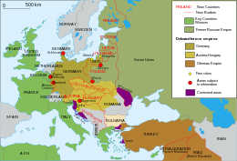
Hungary edit

The restoration of the borders of Hungary to their state prior to World War I, in order to unite all ethnic Hungarians within the same country once again.
Hungarian irredentism or Greater Hungary are irredentist and revisionist political ideas concerning redemption of territories of the historical Kingdom of Hungary. The idea is associated with Hungarian revisionism, targeting at least to regain control over Hungarian-populated areas in Hungary's neighbouring countries. Hungarian historians did not use the term Greater Hungary, because the "Historic Hungary" is the established term for the Kingdom of Hungary before 1920.
The Treaty of Trianon defined the borders of the new independent Hungary and, compared against the claims of the pre-war Kingdom, new Hungary had approximately 72% less land stake and about two-thirds fewer inhabitants, almost 5 million of these being of Hungarian ethnicity.[105][106] However, only 54% of the inhabitants of the pre-war Kingdom of Hungary were Hungarians before World War I.[107][108] Following the treaty's instatement, Hungarian leaders became inclined towards revoking some of its terms. This political aim gained greater attention and was a serious national concern up through the second World War.[109]

Irredentism in the 1930s led Hungary to form an alliance with Nazi Germany. Eva S. Balogh states: "Hungary's participation in World War II resulted from a desire to revise the Treaty of Trianon so as to recover territories lost after World War I. This revisionism was the basis for Hungary's interwar foreign policy."[110]
Between November 1938 and April 1941, Hungary took full advantage of German patronage and, in four different stages, approximately doubled her size. Ethnically, these acquisitions were a mixed bag, some were populated mostly by Hungarians, while others, such as the remainder of Carpathian Ruthenia, were almost wholly non-Hungarian in composition. However, regarding partitioned Transylvania, the population was mixed, near equal between Hungarians and non-Hungarians.[111]
Hungary began with the First Vienna Award in 1938 (redeeming southern Slovakia from Czechoslovakia with mainly Hungarians) and the Second Vienna Award in 1940 (Northern Transylvania). Through military campaigns it gained the remainder of Carpathian Ruthenia in 1939. In 1941 it added the Yugoslav parts of Bačka, Baranja, Međimurje, and Prekmurje.
After defeat in 1945, the borders of Hungary as defined by the Treaty of Trianon were restored, except for three Hungarian villages that were transferred to Czechoslovakia. These villages are today administratively a part of Bratislava.[112]
Italy edit
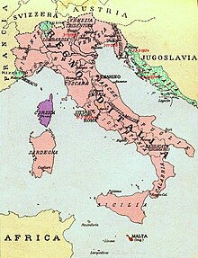
Italian irredentism was a political movement during the late 19th and early 20th centuries in Italy with irredentist goals which promoted the unification of geographic areas in which indigenous peoples were ethnic Italians. At the beginning, the movement promoted the annexation to Italy of territories where Italians formed the absolute majority of the population, but retained by the Austrian Empire after the Third Italian War of Independence in 1866.[113] During World War I the main "irredent lands" (terre irredente) were considered to be the provinces of Trento and Trieste and, in a narrow sense, irredentists referred to the Italian patriots living in these two areas.[113]
Italian irredentism was not a formal organization but rather an opinion movement, advocated by several different groups, claiming that Italy had to reach its "natural borders" or unify territories inhabited by Italians.[113] Similar nationalistic ideas were common in Europe in the late 19th century. This idea of Italia irredenta is not to be confused with the Risorgimento, the historical events that led to irredentism, nor with nationalism or Imperial Italy, the political philosophy that took the idea further under fascism.[114]
The term was later expanded to also include multilingual and multiethnic areas, where Italians were a relative majority or a substantial minority, within the northern Italian region encompassed by the Alps, with German, Italian, Slovene, Croatian, Ladin and Istro-Romanian population, such as South Tyrol, Istria, Gorizia and Gradisca and part of Dalmatia. The claims were further extended also to the city of Fiume, Corsica, the island of Malta, the County of Nice and Italian Switzerland.[113][115]
After the end of World War I, the Italian irredentist movement was hegemonised, manipulated and distorted by fascism, which made it an instrument of nationalist propaganda, placed at the center of a policy, conditioned by belated imperial ambitions, which took the form of "forced Italianizations" , in the aspiration for the birth of a Great Italy and a vast Italian Empire.[114] After World War II, Italian irredentism disappeared along with the defeated Fascists and the Monarchy of the House of Savoy. After the Treaty of Paris (1947) and the Treaty of Osimo (1975), all territorial claims were abandoned by the Italian Republic (see Foreign relations of Italy).[116] The Italian irredentist movement thus vanished from Italian politics.
Lithuania edit

Ethnographic Lithuania is a nationalist concept that defines Lithuanian territories as a significant part of the territories that belonged to the Grand Duchy of Lithuania and Lithuanians as all people living on them, regardless of whether those people contemporarily or currently speak the Lithuanian language and considered themselves Lithuanian. According to the supporters of the ethnographic Lithuania, Lithuanian Poles and Northwestern Belarusians were "slavicized Lithuanians" who needed to be re-Lithuanized. They argued that an individual cannot decide on his ethnicity and nationality, which are decided not by language but ancestry.[117]
North Macedonia edit
Some Macedonian nationalists promoted the irredentist concept of a United Macedonia (Macedonian: Обединета Македонија, romanized: Obedineta Makedonija) among ethnic Macedonian nationalists, which involves territorial claims on the northern province of Macedonia in Greece, but also in Blagoevgrad Province ("Pirin Macedonia") in Bulgaria, Albania, and Serbia. The United Macedonia concept aims to unify the transnational region of Macedonia in the Balkans (which they claim as their homeland and which they assert was wrongfully divided under the Treaty of Bucharest in 1913), into a single state under their domination, with Thessaloniki (Solun in the Slavic languages) as its capital.[118][119]
Norway edit
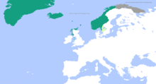
The Kingdom of Norway had several territorial disputes throughout its history, mainly regarding islands and sea boundaries in the Arctic Ocean.[120] The Old Kingdom of Norway, which was the Norwegian territories at its maximum extent, included Iceland, the settleable areas of Greenland, the Faroe Islands, and the Northern Isles and Hebrides (today part of Scotland). Under Danish sovereignty since they established a hegemonic position in the Kalmar Union, the territories were considered as Norwegian colonies. When in the Treaty of Kiel in 1814, Norway's territories were transferred from Denmark to Sweden, the territories of Iceland, Greenland, and the Faroe Islands were maintained by Denmark.
In 1919, the foreign minister of Norway, Nils Claus Ihlen, declared that the Norwegians would not object to a claim of Denmark to the whole island of Greenland, which at the time was mostly occupied by Danish colonies, with a few Norwegian settlements in the eastern part of the island. The claim was formally declared in 1921,[121] but the Norwegian government rejected Denmark's claim and later stated that parts of eastern Greenland belonged to Norway. A dispute between the two countries was not settled until 1933, by the Permanent Court of International Justice.[122] The court concluded that Denmark had sovereignty of the whole island of Greenland, ending Norwegian control over Erik the Red's Land. Norway formerly included the provinces Jämtland, Härjedalen, Idre-Särna (lost since the Second Treaty of Brömsebro), and Bohuslän (lost since the Treaty of Roskilde), which were ceded to Sweden after Danish defeats in wars such as the Thirty Years' War and Second Northern War.
Poland edit
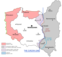
Kresy ("Borderlands") are the eastern lands that formerly belonged to Poland and held a sizable amount of Polish population. In 1921, during the Polish-Soviet war, Polish troops crossed the Curzon Line that had been declared as the eastern polish border by an international commission, and in the Kiev offensive (1920) conquered territories, now today inside the borders of Ukraine and Belarus, which were claimed to have been taken from Poland during the Partitions of Poland, and also seized 7 percent of Lithuania's territory. The new polish territories east of the Curzon line were taken back by the Soviet Union in 1939 under the Molotov–Ribbentrop Pact after the Soviet-German invasion of Poland, and include major cities, like Lviv (Lwów) (nowadays Ukraine), Vilnius (Wilno) (today the capital of Lithuania), and Hrodna (Grodno) (Belarus), which all had majority Polish population.[citation needed] Even though Kresy, or the Eastern Borderlands, are no longer Polish territories, the area is still inhabited by a significant Polish minority, and the memory of the Polish Kresy is still cultivated. The attachment to the "myth of Kresy", the vision of the region as a peaceful, idyllic, rural land, has been criticized in Polish discourse.[123]
In January, February and March 2012, the Centre for Public Opinion Research conducted a survey, asking Poles about their ties to the Kresy. It turned out that almost 15% of the population of Poland (4.3–4.6 million people) declared that they had either been born in the Kresy, or had a parent or a grandparent who came from that region. Numerous treasures of Polish culture remain and there are numerous Kresy-oriented organizations. There are Polish sports clubs (Pogoń Lwów, and formerly FK Polonia Vilnius), newspapers (Gazeta Lwowska, Kurier Wileński), radio stations (in Lviv and Vilnius), numerous theatres, schools, choirs and folk ensembles. Poles living in Kresy are helped by Fundacja Pomoc Polakom na Wschodzie, a Polish government-sponsored organization, as well as other organizations, such as The Association of Help of Poles in the East Kresy (see also Karta Polaka). Money is frequently collected to help those Poles who live in the Kresy, and there are several annual events, such as a Christmas Package for a Polish Veteran in Kresy, and Summer with Poland, sponsored by the Association "Polish Community", in which Polish children from Kresy are invited to visit Poland.[124] Polish language handbooks and films, as well as medicines and clothes are collected and sent to Kresy. Books are most often sent to Polish schools which exist there—for example, in December 2010, The University of Wrocław organized an event called Become a Polish Santa Claus and Give a Book to a Polish Child in Kresy.[125] Polish churches and cemeteries (such as Cemetery of the Defenders of Lwów) are renovated with money from Poland.
Portugal edit
Portugal does not recognize Spanish sovereignty over the territory of Olivenza, ceded to Spain during the Napoleonic Wars.[126]
Romania edit
Romanian nationalists lay claims to Greater Romania, but especially to Moldova, most of the territory which was part of the country between 1918 and 1940. Moldovan was the Soviet name for the Romanian language. There is some (but not universal) support by Moldovans for a peaceful and voluntary reunion with Romania, not least because (having joined the European Union), the economy has burgeoned and Romanian citizens have gained freedom of movement in Europe. Also, Russian irredentism over Transnistria has caused alarm and resentment.
Russia edit

The annexation of Crimea by the Russian Federation in 2014 was based on a claim of protecting ethnic Russians residing there. Crimea was part of the Russian Empire from 1783 to 1917, after which it enjoyed a few years of autonomy until it was made part of the Russian Soviet Federative Socialist Republic (which was a part of the Soviet Union) from 1921 to 1954 and then transferred to Soviet Ukraine (which also was a part of the Soviet Union) in 1954. After the dissolution of the Soviet Union, Crimea still remained part of Ukraine until February 2014. Russia declared Crimea to be part of the Russian Federation in March 2014, and effective administration commenced. The Russian regional status is not currently recognised by the UN General Assembly (Resolution 68/262) and by most countries.
Russian irredentism also includes southeastern and coastal Ukraine, known as Novorossiya, a term from the Russian Empire.
If the 12 July 2021 essay On the Historical Unity of Russians and Ukrainians, published by President Vladimir Putin, is to be considered an official Russian position, then its irredentist claims now extend to the entire territory of historical Ukraine and Belarus, including some areas now part of Romania.
Serbia edit

Serbian irredentism is manifested in Greater Serbia, the Serbian nationalist ideology. Greater Serbia consists of Serbia, North Macedonia, Bosnia and Herzegovina, Montenegro and large parts of Croatia. Used in the context of the Yugoslav wars, however, the Serbian struggle for Serbs to remain united in one country does not quite fit the term "irredentism".[127] In the 19th century, Pan-Serbism sought to unite all of the Serb people across the Balkans, under Ottoman and Habsburg rule. Some intellectuals sought to unite all South Slavs (regardless of religion) into a Serbian state. Serbia had gained independence from the Ottoman Empire in 1878. Bosnia and Herzegovina, annexed by the Austrians in 1908, was viewed of as a part of the Serbian homeland. Serbia directed its territorial aspirations to the south, as the north and west was held by Austria. Macedonia was divided between Serbia, Bulgaria and Greece after the Balkan Wars.
In 1914, aspirations were directed towards Austria-Hungary. A government policy sought to incorporate all Serb-inhabited areas, and other South Slavic areas, thereby laying the foundation of Yugoslavia.[128] With the establishment of the Kingdom of Serbs, Croats and Slovenes (later Yugoslavia), the Serbs now lived united in one country.[127] During the breakup of Yugoslavia, the Serb political leadership in break-away Croatia and Bosnia and Herzegovina declared their territories to be part of the Federal Republic of Yugoslavia (Serbia and Montenegro).
The project of unification of Serb-inhabited areas in Croatia and Bosnia and Herzegovina during the Yugoslav Wars (see United Serb Republic) ultimately failed. The Croatian Operation Storm ended large-scale combat and captured most of the Republic of Serbian Krajina, while the Dayton Agreement ended the Bosnian War. Bosnia and Herzegovina was established as a federal republic, made up by two separate entities, one being Serb-inhabited Republika Srpska. There has since been calls by Bosnian Serb politicians for the secession of Republika Srpska, and possible unification with Serbia.
After the Kosovo War (1998–99), Kosovo became a UN protectorate, still de jure part of Serbia. The Albanian-majority Kosovo assembly unilaterally declared the independence of Kosovo in 2008, and its status since is disputed.
Sweden edit
The Åland islands were disputed at one point, due to it having a population that overwhelmingly speaks Swedish.
North America edit
Mexico edit

In the Treaty of Guadalupe Hidalgo (1848) following the Mexican–American War (1845–48), Mexico ceded claims to what is now the Western and Southwestern United States to the United States (see Mexican Cession). The Cortina and Pizaña uprisings of 1859 and 1915 were influenced by irredentist ideas and the "proximity of the international boundary".[129] The unsuccessful Pizaña uprising "was the last major armed protest on the part of Texas-Americans" (Tejanos).[130] This 1915 uprising and the Plan of San Diego that preceded it marked the high point in Mexican irredentist sentiments.[131][132]
In the early years of the Chicano Movement (El Movimiento) in the 1960s and 1970s, some movement figures "were political nationalists who advocated the secession of the Southwest from the Anglo republic of the United States of America, if not fully, at least locally with regard to Chicano self-determination in local governance, education and means of production".[133] For example, in the 1970s, Reies Tijerina and his group La Alianza, espoused various separatist, secessionist, or irredentist beliefs.[134] The Plan Espiritual de Aztlán, written during the First Chicano National Youth Conference in 1969, also stated "the fundamental Chicano nationalist goal of reclaiming Aztlán"—a reference to ancient Mexican myth—as "the rightful homeland of the Chicanos".[133] However, "Most Chicano nationalists ... did not express the extreme desire for secession from the United States, and the nationalism they expressed weighed more heavily toward the broadly cultural than the explicitly political."[133]
Today, there is virtually no Mexican American support for "separatist policies of self-determination".[135] "Ethnonational irredentism by Mexicans in territories seized by the United States" following the Mexican–American War "declined after the failure of several attempted revolts at the end of the nineteenth century, in favor of internal ... struggles for immigrant and racial civil rights" in the United States.[136] Neither the Mexican government nor any significant Mexican-American group "makes irredentist claims upon the United States".[137] In the modern era, there "has been no evidence of irredentist sentiments among Mexican-Americans, even in such formerly Mexican territories as Southern California, ... nor of disloyalty to the United States, nor of active interest in the politics of Mexico".[138]
edit
Afghanistan edit
The Afghan border with Pakistan, known as the Durand Line, was agreed to by Afghanistan and British India in 1893. The Pashtun tribes inhabiting the border areas were divided between what have become two nations; Afghanistan never accepted the still-porous border and clashes broke out in the 1950s and 1960s between Afghanistan and Pakistan over the issue. All Afghan governments of the past century have declared, with varying intensity, a long-term goal of re-uniting all Pashtun-dominated areas under Afghan rule.[139][140] No other country in the world accepts Afghanistan's unilateral claim that the Durand Line is in dispute. Afghan claims over Pakistani territory have detrimentally affected Afghanistan–Pakistan relations.
Korea edit

Since their founding, both Korean states have disputed the legitimacy of the other. The Constitution of North Korea stresses the importance of reunification, but, while it makes no similar formal provision for administering the South, it effectively claims its territory as it does not diplomatically recognise the Republic of Korea, deeming it an "entity occupying the Korean territory".
South Korea's constitution also claims jurisdiction over the entire Korean peninsula. It acknowledges the division of Korea only indirectly by requiring the president to work for reunification. The Committee for the Five Northern Korean Provinces, established in 1949, is the South Korean authority charged with the administration of Korean territory north of the Military Demarcation Line (i.e., North Korea), and consists of the governors of the five provinces, who are appointed by the President. However the body is purely symbolic and largely tasked with dealing with Northern defectors; if reunification were to occur the committee would be dissolved and new administrators appointed by the Ministry of Unification.[141]
Pakistan edit
Pakistan and India have from their independence sought to have the territory of Kashmir incorporated into them. Pakistan's and India's dispute over the territory of Kashmir stems from events leading up to independence from the British.
See also edit
References edit
- ^ "WAR AND NATION: IDENTITY AND THE PROCESS OF STATE-BUILDING IN SOUTH AMERICA (1800-1840)". Leverhulme Trust. University of Kent. Retrieved 28 September 2019.
- ^ "CONSTITUTION OF THE ARGENTINE NATION". pp. Temporary Provisions. Archived from the original on 4 June 2011. Retrieved 12 January 2020.
- ^ "Argentina presses claim to Falkland Islands, accusing UK of colonialism". CNN. Retrieved 8 January 2012.
- ^ "Constitución Nacional" (in Spanish). 22 August 1994. Archived from the original on 17 June 2004. Retrieved 17 June 2011.
- ^ "Constitution of the Argentine Nation". 22 August 1994. Archived from the original on 4 June 2011. Retrieved 17 June 2011.
- ^ CAPÍTULO CUARTO, REIVINDICACIÓN MARÍTIMA. Artículo 267. I. El Estado boliviano declara su derecho irrenunciable e imprescriptible sobre el territorio que le dé acceso al océano Pacífico y su espacio marítimo. II. La solución efectiva al diferendo marítimo a través de medios pacíficos y el ejercicio pleno de la soberanía sobre dicho territorio constituyen objetivos permanentes e irrenunciables del Estado boliviano.Constitution of Bolivia Archived 2017-10-24 at the Wayback Machine
- ^ "UN court rejects Bolivia's bid for sea access via Chile". The Telegraph. Agence France-Presse. 1 October 2018. ISSN 0307-1235. Retrieved 20 February 2022.
- ^ "Bolivia dice que su demanda marítima es una cuestión "abierta y pendiente"". Hola News. 23 March 2021. Archived from the original on 12 November 2021. Retrieved 20 February 2022.
- ^ "Every year on 'Día Del Mar,' Bolivia celebrates the coastline they lost". The World. 22 March 2019. Retrieved 20 February 2022.
- ^ "The One-China Principle and the Taiwan Issue". PRC Taiwan Affairs Office and the Information Office of the State Council. 2005. Archived from the original on 13 February 2006. Retrieved 6 March 2006.
- ^ Horton, Chris (2 September 2018). "Once a Cold War Flashpoint, a Part of Taiwan Embraces China's Pull". The New York Times. Retrieved 5 February 2019.
- ^ "Treaty of Shimonoseki". Encyclopædia Britannica. 2018. Retrieved 5 February 2019.
- ^ Wright, David Curtis (1 January 2011). The History of China. ABC-CLIO. p. 113. ISBN 9780313377488.
In May 1985 a short lived republic was declared in Taiwan...
- ^ "Republic of Formosa. Most Short-Lived Government That Has Ever Existed". Sacramento Daily Record-Union. Sacramento. 20 July 1895. p. 8.
Denby confirms the statement made that a republican form of government was instituted, and says: "This republic will pass into history as the most short-lived government that ever existed. ......"
- ^ "Taiwan". Encyclopædia Britannica. 2019. Retrieved 5 February 2019.
- ^ UN General Assembly, Forty-ninth session: Agenda item 36 Archived May 27, 2008, at the Wayback Machine
- ^ Security Council S/PV. 1888 para 247 S/11967 "Archived copy". Archived from the original on 17 March 2008. Retrieved 13 November 2006.
{{cite web}}: CS1 maint: archived copy as title (link) "Archived copy". Archived from the original (PDF) on 17 March 2008. Retrieved 21 October 2013.{{cite web}}: CS1 maint: archived copy as title (link) - ^ "Indonesias foreign policy since the implementation of guided democracy". Twenty years Indonesian foreign policy 1945–1965. Walter de Gruyter GmbH & Co KG. 3 December 2018. p. 472.
- ^ Kadir, Norozan (July 2017). "The Formation Of Malaysia And The Philippines' Alternative Plan To Claim Sabah After Its Unsuccessful Irredentism Mission, 1963-1965". Jebat: Malaysian Journal of History, Politics & Strategic Studies. 44 (1): 180–214.
- ^ Putin, Vladimir (12 July 2021). "On the Historical Unity of Russians and Ukrainians".
- ^ "Analysis | Russia's land grabs in Ukraine could break the international order". Washington Post. ISSN 0190-8286. Retrieved 9 March 2022.
- ^ Wilson, Andrew (20 April 2016). "The Donbas in 2014: Explaining Civil Conflict Perhaps, but not Civil War". Europe-Asia Studies. 68 (4): 631–652. doi:10.1080/09668136.2016.1176994. ISSN 0966-8136. S2CID 148334453.
- ^ The Committee Office, House of Commons. "Answer to Q257 at the FAC hearing". Publications.parliament.uk. Retrieved 5 August 2013.
- ^ Djurkovic, Misa (March 2007). "Montenegro: Headed for New Divisions?" (PDF). www.da.mod.uk. Archived from the original (PDF) on 26 June 2008.
- ^ Bogdani, Mirela; John Loughlin (2007). Albania and the European Union: the tumultuous journey towards integration. IB Taurus. p. 230. ISBN 978-1-84511-308-7. Retrieved 28 May 2010.
- ^ a b Likmeta, Besar (17 November 2010). "Poll Reveals Support for 'Greater Albania'". Balkan Insight.
- ^ "Balkan Monitor: Insights and Perceptions: Voices of The Balkans" (PDF). Gallup. 2010. Archived from the original (PDF) on 14 December 2010.
- ^ Albania celebrates 100 years of independence, yet angers half its neighbors Associated Press, November 28, 2012.[1] [dead link]
- ^ "Armenia: Internal Instability Ahead" (PDF). Yerevan/Brussels: International Crisis Group. 18 October 2004. p. 8. Archived from the original (PDF) on 3 March 2016. Retrieved 11 June 2014.
The Dashnaktsutiun Party, which has a major following within the diaspora, states as its goals: "The creation of a Free, Independent, and United Armenia. The borders of United Armenia shall include all territories designated as Armenia by the Treaty of Sevres as well as the regions of Artzakh [the Armenian name for Nagorno-Karabakh], Javakhk, and Nakhichevan".
- ^ Hovannisian, Richard G. (2008). The Armenian Genocide: Cultural and Ethical Legacies. New Brunswick, New Jersey: Transaction Publishers. p. 22. ISBN 978-1-4128-3592-3.
- ^ Jones, Adam (2013). Genocide: A Comprehensive Introduction. Routledge. p. 114. ISBN 978-1-134-25981-6.
- ^ Theriault, Henry (6 May 2010). "The Global Reparations Movement and Meaningful Resolution of the Armenian Genocide". The Armenian Weekly. Archived from the original on 10 May 2010.
- ^ Stepanyan, S. (2012). "Հայոց ցեղասպանության ճանաչումից ու դատապարտումից մինչև Հայկական հարցի արդարացի լուծում [From the Recognition and Condemnation of the Armenian Genocide to the Just Resolution of the Armenian Question]". Lraber Hasarakakan Gitutyunneri (in Armenian). 1 (1). Yerevan: Armenian Academy of Sciences: 34. ISSN 0320-8117.
Արդի ժամանակներում Հայկական հարցը իր էությամբ նպատակամղված է Թուրքիայի կողմից արևմտահայության բնօրրան, ցեղասպանության և տեղահանության ենթարկված Արևմտյան Հայաստանը` հայրենիքը կորցրած հայերի ժառանգներին և Հայաստանի Հանրապետությանը վերադարձնելուն:
- ^ Africa Research, Ltd (1966). Africa Research Bulletin, Volume 3. Blackwell. p. 597. Retrieved 18 December 2014.
- ^ Barrington, Lowell, After Independence: Making and Protecting the Nation in Postcolonial and Postcommunist States, (University of Michigan Press: 2006), p.115
- ^ "UAE forces 'occupy' sea and airports on Yemen's Socotra". Al Jazeera. Retrieved 7 August 2021.
- ^ Addis, Adeno (January 2012). "Imagining the Homeland from Afar: Community and Peoplehood in the Age of the Diaspora". Vanderbilt Journal of Transnational Law. 45 (4): 963.
- ^ http://www.bundesheer.at/pdf_pool/publikationen/hasa03.pdf [bare URL PDF]
- ^ "Swazi History - Olden Times - Swaziland National Trust Commission". www.sntc.org.sz. Archived from the original on 16 February 2020. Retrieved 28 April 2020.
- ^ "BORDER RESTORATION COMMITTEE". Times of Swaziland. 25 November 2013.
- ^ The Origins of War: From the Stone Age to Alexander the Great By Arther Ferrill – p. 70
- ^ Minorities in the Middle East: a history of struggle and self-expression By Mordechai Nisan
- ^ Donabed, Sargon (1 February 2015). Reforging a Forgotten History: Iraq and the Assyrians in the Twentieth Century. Edinburgh University Press. ISBN 9780748686056 – via Google Books.
- ^ "Present-day Armenia located in ancient Azerbaijani lands – Ilham Aliyev". News.Az. 16 October 2010. Archived from the original on 21 July 2015.
- ^ Patrick Barron. "Dr Laurence Broers, The resources for peace: comparing the Karabakh, Abkhazia and South Ossetia peace processes, Conciliation Resources, 2006". C-r.org. Retrieved 21 May 2014.
- ^ CRIA. "Fareed Shafee, Inspired from Abroad: The External Sources of Separatism in Azerbaijan, Caucasian Review of International Affairs, Vol. 2 (4) – Autumn 2008, pp. 200–211". Cria-online.org. Archived from the original on 3 October 2011. Retrieved 21 May 2014.
- ^ What is Irredentism? Archived 2014-02-22 at the Wayback Machine SEMP, Biot Report #224, USA, June 21, 2005
- ^ "Saideman, Stephen M. and R. William Ayres, For Kin and Country: Xenophobia, Nationalism and War, New York, N.Y.: Columbia University Press, 2008" (PDF). Retrieved 21 May 2014.
- ^ Irredentism enters Armenia's foreign policy, Jamestown Foundation Monitor Volume: 4 Issue: 77, Washington DC, April 22, 1998
- ^ Prof. Thomas Ambrosio, Irredentism: ethnic conflict and international politics, Greenwood Publishing Group, 2001
- ^ Milanova, Nadia (2003). "The Territory-Identity Nexus in the Conflict over Nagorno Karabakh". Flensburg, Germany: European Centre for Minority Issues. p. 2. Retrieved 12 July 2013.
The conflict over Nagorno Karabakh, defined as an amalgam of separatism and irredentism ...
- ^ Ian Bremmer and Ray Taras. New States, New Politics: Building Post-Soviet Nations, p. 444. ISBN 0-521-57799-3
- ^ "President.Az -". en.president.az. Archived from the original on 20 August 2016. Retrieved 15 August 2016.
- ^ "Chinese Irredentism and the Great Rejuvenation". Indian Defence Review. Retrieved 31 August 2020.
- ^ Yale H. Ferguson and R. J. Barry Jones, Political space: frontiers of change and governance in a globalizing world, page 155, SUNY Press, 2002, ISBN 978-0-7914-5460-2
- ^ Sucheta Majumder, "Right Wing Mobilization in India", Feminist Review, issue 49, page 17, Routledge, 1995, ISBN 978-0-415-12375-4
- ^ Ulrika Mårtensson and Jennifer Bailey, Fundamentalism in the Modern World (Volume 1), page 97, I.B.Tauris, 2011, ISBN 978-1-84885-330-0
- ^ Suda, Jyoti Prasad (1953). India, Her Civic Life and Administration. Jai Prakash Nath & Co. Retrieved 23 July 2014.
Its members still swear by the ideal of Akhand Hindustan.
- ^ Hindu Political Parties. General Books. 30 May 2010. ISBN 9781157374923.
- ^ M.A., Laskar (2015). Dynamics of Indian federalism: A comprehensive historical review. Notion Press. p. 43. ISBN 978-9352062386.
- ^ McIntyre, Angus (1973). "The 'Greater Indonesia' Idea of Nationalism in Malaysia and Indonesia". Modern Asian Studies. 7 (1): 75–83. doi:10.1017/S0026749X0000439X. S2CID 145234977.
- ^ a b c d Erik Goldstein, Erik (Dr.). Wars and Peace Treaties: 1816 to 1991. P133.
- ^ Professor Richard Frye states: The Turkish speakers of Azerbaijan are mainly descended from the earlier Iranian speakers, several pockets of whom still exist in the region (Frye, Richard Nelson, "Peoples of Iran", in Encyclopedia Iranica).
- ^ Swietochowski, Tadeusz. "AZERBAIJAN, REPUBLIC OF", Vol. 3, Colliers Encyclopedia CD-ROM, 02-28-1996: "The original Persian population became fused with the Turks, and gradually the Persian language was supplanted by a Turkic dialect that evolved into the distinct Azerbaijani language."
- ^ Golden, P.B. "An Introduction to the History of the Turkic Peoples", Otto Harrosowitz, 1992. "The Azeris of today are an overwhelmingly sedentary, detribalized people. Anthropologically, they are little distinguished from the Iranian neighbor"
- ^ de Planhol, Xavier. "Iran i. Lands of Iran". Encyclopedia Iranica.
The toponymy, with more than half of the place names of Iranian origin in some areas, such as the Sahand, a huge volcanic massif south of Tabriz, or the Qara Dagh, near the border (Planhol, 1966, p. 305; Bazin, 1982, p. 28) bears witness to this continuity. The language itself provides eloquent proof. Azeri, not unlike Uzbek (see above), lost the vocal harmony typical of Turkish languages. It is a Turkish language learned and spoken by Iranian peasants.
- ^ "Thus Turkish nomads, in spite of their deep penetration throughout Iranian lands, only slightly influenced the local culture. Elements borrowed by the Iranians from their invaders were negligible."(X.D. Planhol, LANDS OF IRAN in Encyclopedia Iranica)
- ^ История Востока. В 6 т. Т. 2. Восток в средние века. Глава V. — М.: «Восточная литература», 2002. — ISBN 5-02-017711-3. Excerpt: "Говоря о возникновении азербайджанской культуры именно в XIV-XV вв., следует иметь в виду прежде всего литературу и другие части культуры, органически связанные с языком. Что касается материальной культуры, то она оставалась традиционной и после тюркизации местного населения. Впрочем, наличие мощного пласта иранцев, принявших участие в формировании азербайджанского этноса, наложило свой отпечаток прежде всего на лексику азербайджанского языка, в котором огромное число иранских и арабских слов. Последние вошли и в азербайджанский, и в турецкий язык главным образом через иранское посредство. Став самостоятельной, азербайджанская культура сохранила тесные связи с иранской и арабской. Они скреплялись и общей религией, и общими культурно-историческими традициями." (History of the East. 6 v. 2. East during the Middle Ages. Chapter V. – M.: «Eastern literature», 2002. – ISBN 5-02-017711-3.). Translation: "However, the availability of powerful layer of Iranians took part in the formation of the Azerbaijani ethnic group, left their mark primarily in the Azerbaijani language, in which a great number of Iranian and Arabic words. The latter included in the Azeri, and Turkish language primarily through Iranian mediation."
- ^ Marcinkowski, Christoph (2010). Shi'ite Identities: Community and Culture in Changing Social Contexts. LIT Verlag Münster. p. 83. ISBN 978-3-643-80049-7.
- ^ "Interview with Richard N. Frye (CNN)". 2007. Archived from the original on 23 April 2016. Retrieved 19 April 2017.
- ^ Frye, Richard Nelson (October 1962). "Reitzenstein and Qumrân Revisited by an Iranian". The Harvard Theological Review. 55 (4): 261–268. doi:10.1017/S0017816000007926. JSTOR 1508723. S2CID 162213219.
I use the term Iran in an historical context [...] Persia would be used for the modern state, more or less equivalent to "western Iran". I use the term "Greater Iran" to mean what I suspect most Classicists and ancient historians really mean by their use of Persia – that which was within the political boundaries of States ruled by Iranians
- ^ "IRAN i. LANDS OF IRAN". Encyclopædia Iranica.
- ^ Dialect, Culture, and Society in Eastern Arabia: Glossary. Clive Holes. 2001. Page XXX. ISBN 90-04-10763-0
- ^ Lange, Christian (19 July 2012). Justice, Punishment and the Medieval Muslim Imagination. Cambridge Studies in Islamic Civilization. Cambridge University Press. ISBN 9781107404618. Archived from the original on 12 November 2020.
I further restrict the scope of this study by focusing on the lands of Iraq and greater Persia (including Khwārazm, Transoxania, and Afghanistan).
- ^ Gobineau, Joseph Arthur; O'Donoghue, Daniel. Gobineau and Persia: A Love Story. ISBN 1-56859-262-0. Archived from the original on 23 July 2011. O'Donoghue: "... all set in the greater Persia/Iran which includes Afghanistan".
- ^ Shiels, Stan (2004). Stan Shiels on centrifugal pumps: collected articles from "World Pumps" magazine. Elsevier. pp. 11–12, 18. ISBN 1-85617-445-X. Shiels: "During the Sassanid period the term Eranshahr was employed to denote the region also known as Greater Iran ..." Also: "... the Abbasids, who with Persian assistance assumed the Prophet's mantle and transferred their capital to Baghdad three years later; thus, on a site close to historic Ctesiphon and even older Babylon, the caliphate was established within the bounds of Greater Persia."
- ^ "Columbia College Today". columbia.edu. Archived from the original on 27 November 2015. Retrieved 9 December 2015.
- ^ R. Stephen Humphreys, Between Memory and Desire: The Middle East in a Troubled Age, University of California Press, 1999, p. 105.
- ^ Duiker, William J; Spielvogel, Jackson J. World History: From 1500. 5th edition. Belmont, California, USA: Thomson Wadsworth, 2007. Pp. 839.
- ^ Helen Chapin Metz, ed. Iraq A Country Study. Kessinger Publishing, 2004 Pp. 65.
- ^ Raymond A. Hinnebusch. The international politics of the Middle East. Manchester, England, UK: Manchester University Press, 2003 Pp. 209.
- ^ Kevin M. Woods, David D. Palkki, Mark E. Stout. The Saddam Tapes: The Inner Workings of a Tyrant's Regime, 1978-2001. Cambridge University Press, 2011. Pp. 131-132
- ^ Nathan E. Busch. No End in Sight: The Continuing Menace of Nuclear Proliferation. Lexington, Kentucky, USA: University of Kentucky Press, 2004. Pp. 237.
- ^ Amatzia Baram, Barry Rubin. Iraq's Road To War. New York, New York, USA: St. Martin's Press, 1993. Pp. 127.
- ^ Sharad S. Chauhan. War On Iraq. APH Publishing, 2003. Pp. 126.
- ^ a b Middle East Contemporary Survey, Volume 14; Volume 1990. Pp. 606.
- ^ 金得榥,「백두산과 북방강계」, 사사연, 1987, 27쪽
- ^ 북한연구소, 북한총람 (1982) 85쪽.
- ^ Border Disputes with China and North Korea. http://chinaperspectives.revues.org/806
- ^ Ivanov, A. "The problem of the Noktundo Island in the media in South Korea | Asia Pacific Study Center". Retrieved 4 September 2022.
- ^ Kaufman, Asher (30 June 2014). Reviving Phoenicia: The Search for Identity in Lebanon. I.B.Tauris. ISBN 9781780767796 – via Google Books.
- ^ Kamal S. Salibi, "The Lebanese Identity" Journal of Contemporary History 6.1, Nationalism and Separatism (1971:76–86).
- ^ Pipes, Daniel (August 1988). "Radical Politics and the Syrian Social Nationalist Party". International Journal of Middle East Studies. Retrieved 28 January 2017.
- ^ Burg, Steven L.; Shoup, Paul S. (1999). The War in Bosnia-Herzegovina: Ethnic Conflict and International Intervention. M. E. Sharpe. p. 37. ISBN 9780765631893.
- ^ Chazan, Naomi (1991). Irredentism and international politics. Lynne Rienner Publishers. ISBN 9781555872212.
- ^ "Deutschnationale Volkspartei (DNVP)".
- ^ "Vor 90 Jahren: Die Verträge von Locarno". 30 November 2015.
- ^ lemo Lebendiges Museum Online. "LeMO Weimarer Republik - Außenpolitik - Konferenz von Locarno 1925". Dhm.de. Retrieved 8 May 2022.
- ^ "Zentrale Inhalte des Grundgesetzes". September 2008.
- ^ "Chronik-Glossar: Artikel 23 Grundgesetz".
- ^ "Art 23 GG - Einzelnorm".
- ^ "Germany in secret talks with Russia to take back Konigsberg". 21 January 2001.
- ^ "The Status of Kaliningrad Oblast Under International Law - Raymond A. Smith".
- ^ "7 parts of Russia that other countries could call theirs". 27 March 2014.
- ^ Fenyvesi, Anna (2005). Hungarian language contact outside Hungary: studies on Hungarian as a minority language. John Benjamins Publishing Company. p. 2. ISBN 90-272-1858-7. Retrieved 15 August 2011.
- ^ "Treaty of Trianon". Encyclopædia Britannica. 25 September 2023.
- ^ A magyar szent korona országainak 1910. évi népszámlálása. Első rész. A népesség főbb adatai. (in Hungarian). Budapest: Magyar Kir. Központi Statisztikai Hivatal (KSH). 1912.
- ^ Anstalt G. Freytag & Berndt (1911). Geographischer Atlas zur Vaterlandskunde an der österreichischen Mittelschulen. Vienna: K. u. k. Hof-Kartographische. "Census December 31st 1910"
- ^ "HUNGARY". Hungarian Online Resources (Magyar Online Forrás). Archived from the original on 24 November 2010. Retrieved 13 February 2011.
- ^ Eva S. Balogh, "Peaceful Revision: The Diplomatic Road to War." Hungarian Studies Review 10.1 (1983): 43-51. online
- ^ Balogh, p. 44.
- ^ Mark Pittaway, "National socialism and the production of German–Hungarian borderland space on the eve of the second world war." Past & Present 216.1 (2012): 143-180.
- ^ a b c d "IRREDENTISMO" (in Italian). Treccani. Retrieved 9 September 2023.
- ^ a b Monteleone, Renato (1970). "La politica dei Socialisti e democratici irredenti in Italia nella grande guerra". Studi Storici (in Italian). Anno 11 (2): 313–346..
- ^ "La frontiera tra Italia e Svizzera" (in Italian). Retrieved 9 September 2023.
- ^ "L'Italia per De Gaulle: "Non un paese povero, ma un povero paese"" (in Italian). Retrieved 9 September 2023.
- ^ Łossowski, Piotr (1995). Konflikt polsko-litewski 1918-1920 (in Polish). Warszawa: Książka i Wiedza. pp. 13–19. ISBN 83-05-12769-9.
- ^ Greek Macedonia "not a problem", The Times (London), August 5, 1957
- ^ A large assembly of people during the inauguration of the Statue of Alexander the Great in Skopje on YouTube, the players of the national basketball team of the Republic of Macedonia during the European Basketball Championship in Lithuania on YouTube, and a little girl on YouTube, singing a nationalistic tune called Izlezi Momče (Излези момче, "Get out boy"). Translation from Macedonian:
Get out, boy, straight on the terrace
And salute Goce's race
Raise your hands up high
Ours will be Thessaloniki's area. - ^ "Evolution of Arctic Territorial Claims and Agreements: A Timeline (1903-Present) • Stimson Center". Stimson Center. 15 September 2013. Retrieved 13 April 2021.
- ^ Hyde, Charles Cheney (1933). "The Case Concerning the Legal Status of Eastern Greenland". The American Journal of International Law. 27 (4): 732–738. doi:10.2307/2190118. ISSN 0002-9300. JSTOR 2190118. S2CID 146944266.
- ^ Cavell, Janice (2008). "Historical Evidence and the Eastern Greenland Case". Arctic. 61 (4): 433–441. ISSN 0004-0843. JSTOR 40513230.
- ^ "odczarować mit Kresów Czas odczarować mit Kresów Marcin Wojciechowski, Gazeta Wyborcza 2010-04-12".
- ^ Meksa, Michał (28 July 2011). "Dzieci z Kresów zwiedzają Łódź [ZDJĘCIA]".
- ^ "Wiadomości i informacje o książkach i wszelkich przejawach kultury książki". Portal Księgarski.
- ^ Mora, Miguel (3 December 2006). "La eterna disputa de Olivenza-Olivença | Edición impresa | EL PAÍS". El País. Elpais.com. Retrieved 20 April 2014.
- ^ a b Raju G.C Thomas (23 June 2014). The South Slav Conflict: History, Religion, Ethnicity, and Nationalism. Taylor & Francis. pp. 220–. ISBN 978-1-135-59717-7.
- ^ Steven L. Danver (22 December 2010). Popular Controversies in World History: Investigating History's Intriguing Questions [4 volumes]: Investigating History's Intriguing Questions. ABC-CLIO. pp. 3–. ISBN 978-1-59884-078-0.
- ^ Américo Paredes (1993). Folklore and Culture on the Texas-Mexican Border. University of Texas Press. pp. 25–26.
- ^ Américo Paredes (1976). A Texas-Mexican Cancionero: Folksongs of the Lower Border. University of Texas Press. pp. 33–34.
- ^ Leo Cervantes (2004). More Than a Century of the Chicano Movement. Orbis Press. p. 55.
- ^ John R. Chávez (1984). The Lost Land: The Chicano Image of the Southwest. University of New Mexico Press. p. 79.
- ^ a b c Patricia L. Price (2004). Dry Place: Landscapes of Belonging and Exclusion. University of University Press, 2004. pp. 67–70. ISBN 9780816643059.
- ^ Leo Cervantes (2004). More Than a Century of the Chicano Movement. Orbis Press. pp. 61–67.
- ^ Navarro, Armando (2005). Mexicano political experience in occupied Aztlán: struggles and change. Walnut Creek, California: AltaMira Press. p. 118. ISBN 978-0-7591-0567-6.
- ^ Josiah M. Heyman & John Symons (2012). "Borders". In Didier Fassin (ed.). A Companion to Moral Anthropology (paperback 2015 ed.). John Wiley & Sons. p. 553.
- ^ Walker Connor (1994). Mexican-Americans in Comparative Perspective. Urban Institute Press. p. 155.
- ^ Milton J. Esman (1994). Ethnic Politics. Cornell University Press. pp. 61–67.
- ^ Dr. G. Rauf Roashan, "The Unholy Durand Line, Buffering the Buffer", Institute for Afghan Studies, August 11, 2001. Archived March 25, 2012, at the Wayback Machine
- ^ Harrison, Selig S. (11 May 2009). "The Fault Line Between Pashtuns and Punjabis in Pakistan". The Washington Post.
- ^ "South Korea's Governors-in-Theory for North Korea". The Wall Street Journal. 18 March 2014. Retrieved 29 April 2014.