


Summary
This is a list of all lighthouses in the U.S. state of Maine as identified by the United States Coast Guard.[1] There are fifty-seven active lights in the state, two of which are maintained as private aids; nine are standing but inactive, and three have been destroyed, one of which has been replaced by a skeleton tower. This includes two stations which originally featured twin towers; in both cases both towers survive but only one of each pair is active.
The Portland Head Light, first lit in 1791, is the oldest light in the state and was the first US lighthouse completed after independence from Britain.[2][3] The last lighthouse in the state, the second Whitlocks Mill Light, was first lit in 1910; it is also the most northerly light in the state and therefore on the US Atlantic Coast.[4] The West Quoddy Head Light sits on the easternmost point of the continental United States.[5] The tallest tower is that of Boon Island Light at 137 ft (42 m),[6] though the Seguin Light focal plane, at 180 ft (55 m), is the highest in the state.[2]

Lighthouse preservation in Maine has been facilitated by the Maine Lighthouse Program, which arose in the aftermath of the Rockland-based Island Institute's successful but protracted negotiations to acquire the keeper's house of the Heron Neck Light Station.[7] A program for facilitating transfers was proposed by Peter Ralston of the institute,[8] and legislation was first introduced by George J. Mitchell; a subsequent bill submitted by Olympia Snowe in 1995 met with greater success and was signed into law late in 1996 as part of the coast guard authorization act.[7] Under the program, thirty-six light stations were offered to qualified preservation and historical groups and local governments; applications for transfer were reviewed by a board set up at the state level, headed by Richard I. Rybacki, a retired USCG rear admiral.[7] Four lights were to be transferred to the US Fish and Wildlife; twenty-eight other lights were transferred in the summer of 1998.[7] Prior to this program, some lights in the state had already been sold to individuals following deactivation in the 1930s. The most notable of these is the Tenants Harbor Light, which was purchased by Andrew Wyeth in 1978.[9]
If not otherwise noted, focal height and coordinates are taken from the United States Coast Guard Light List,[10] while location and dates of activation, automation, and deactivation are taken from the United States Coast Guard Historical information site for lighthouses.[1]
Lighthouses edit
| Name | Image | Location | Coordinates | Year first lit | Automated | Year deactivated | Current Lens | Focal Height |
|---|---|---|---|---|---|---|---|---|
| Avery Rock Light | 
|
Machias (Machias Bay) |
44°39′14″N 67°20′38″W / 44.654°N 67.344°W[11] | 1875 | 1926 | 1947 (Destroyed) |
None | 56 ft (17 m)[11] |
| Baker Island Light | 
|
Cranberry Isles (Baker Island) |
44°14′17″N 68°11′56″W / 44.2381°N 68.1990°W | 1828 (Former) 1855 (Current) |
1966 | Active | Fourth-order Fresnel | 105 ft (32 m) |
| Bass Harbor Head Light | 
|
Tremont (Mount Desert Island) |
44°13′18″N 68°20′14″W / 44.2218°N 68.3373°W | 1858 | 1974 | Active | Fourth-order Fresnel | 56 ft (17 m) |
| Bear Island Light | 
|
Cranberry Isles (Bear Island) |
44°17′02″N 68°16′12″W / 44.2838°N 68.270°W | 1839 (Former) 1889 (Current) |
1989 | Active (Inactive: 1981–1989) |
Plastic | 100 ft (30 m) |
| Blue Hill Bay Light | 
|
Blue Hill (Blue Hill Bay) |
44°14′56″N 68°29′52″W / 44.2489°N 68.4977°W[12] | 1857 (Former) 1935 (Current) |
1935 | 1935 (Former) Active (Current) |
Unknown | 25 ft (7.6 m) |
| Boon Island Light | 
|
York (Boon Island) |
43°07′17″N 70°28′35″W / 43.1214°N 70.4764°W | 1811 (Former) 1855 (Current) |
1980 | Active | VRB-25 | 137 ft (42 m) |
| Browns Head Light | 
|
Vinalhaven (Browns Head) |
44°06′42″N 68°54′34″W / 44.1118°N 68.9095°W | 1832 (Former) 1857 (Current) |
1987 | Active | Fifth-order Fresnel | 39 ft (12 m) |
| Burnt Coat Harbor Light | 
|
Swan's Island (Hockamock Head) |
44°08′03″N 68°26′50″W / 44.1341°N 68.4472°W | 1872 | 1975 | Active | Unknown | 75 ft (23 m) |
| Burnt Island Light | 
|
Boothbay Harbor (Burnt Island) |
43°49′31″N 69°38′25″W / 43.8252°N 69.6402°W | 1821 | 1988 | Active | Electrified beacon | 61 ft (19 m) |
| Cape Elizabeth Lights | 
|
Cape Elizabeth (Casco Bay) |
43°33′58″N 70°12′00″W / 43.5661°N 70.2001°W (East tower)43°33′51″N 70°12′09″W / 43.5642°N 70.2025°W (West tower)[13] |
1828 (West tower) 1874 (East tower) |
1963 (East) | 1924 (West) Active (East) |
VRB-25 | 129 ft (39 m) |
| Cape Neddick Light | 
|
York (Cape Neddick) |
43°09′55″N 70°36′28″W / 43.1652°N 70.6078°W | 1879 | 1987 | Active | Fourth-order Fresnel | 88 ft (27 m) |
| Crabtree Ledge Light | 
|
Frenchman Bay (Crabtree Neck) |
44°28′12″N 68°12′11″W / 44.470°N 68.203°W[14] | 1890 | Never | 1933 (Destroyed in 1950[15]) |
None | 37 ft (11 m)[15] |
| Cuckolds Light | 
|
Boothbay Harbor (Cuckold Islets) |
43°46′46″N 69°39′00″W / 43.7795°N 69.6500°W | 1892 (Former) 1907 (Current) |
1972 | Active | VRB-25 | 59 ft (18 m) |
| Curtis Island Light | 
|
Camden (Penobscot Bay) |
44°12′05″N 69°02′56″W / 44.2014°N 69.0489°W | 1835 (Former) 1896 (Current) |
1972 | Active | Unknown | 52 ft (16 m) |
| Deer Island Thorofare Light | 
|
Stonington? (Penobscot Bay) |
44°08′04″N 68°42′12″W / 44.1344°N 68.7033°W | 1857 | 1958 | Active | 250mm | 52 ft (16 m) |
| Dice Head Light | 
|
Castine | 44°22′58″N 68°49′07″W / 44.3827°N 68.8186°W | 1829 | 1937 | Active (Inactive: 1937–2007)[16] |
Unknown | 134 ft (41 m) |
| Doubling Point Range Lights | 
|
Arrowsic (Arrowsic Island) |
43°52′58″N 69°47′45″W / 43.8828°N 69.7957°W (Front light) 43°53′05″N 69°47′45″W / 43.8848°N 69.7957°W (Rear light) |
1898 | 1980 | Active | Unknown | 18 ft (5.5 m) (Front light) 33 ft (10 m) (Rear light) |
| Doubling Point Light | 
|
Arrowsic | 43°52′57″N 69°48′24″W / 43.8825°N 69.8068°W | 1898 | 1988 | Active | Fifth-order Fresnel | 23 ft (7.0 m) |
| Eagle Island Light | 
|
Eagle Island (Penobscot Bay) |
44°13′03″N 68°46′04″W / 44.2176°N 68.7678°W | 1838 (Former) 1858 (Current) |
1959 | Active | Fourth-order Fresnel | 23 ft (7.0 m) |
| Egg Rock Light | 
|
Frenchman Bay | 44°21′14″N 68°08′18″W / 44.3539°N 68.1383°W | 1875 | 1976 | Active | VRB-25 | 64 ft (20 m) |
| Fort Point Light | 
|
Stockton Springs (Penobscot River) |
44°28′02″N 68°48′42″W / 44.4671°N 68.8117°W | 1836 (Former) 1857 (Current) |
1988 | Active | Fourth-order Fresnel | 88 ft (27 m) |
| Franklin Island Light | 
|
Franklin Island (Muscongus Bay) |
43°53′32″N 69°22′29″W / 43.8921°N 69.3746°W | 1805 (Former) 1855 (Current) |
1967 | Active | 250mm | 57 ft (17 m) |
| Goat Island Light | 
|
Kennebunkport (Cape Porpoise) |
43°21′28″N 70°25′30″W / 43.3579°N 70.4251°W | 1835 (Former) 1859 (Current) |
1990 | Active | 300mm | 38 ft (12 m) |
| Goose Rocks Light | 
|
North Haven (Penobscot Bay) |
44°08′07″N 68°49′51″W / 44.1354°N 68.8307°W | 1890 | 1963 | Active | 250mm | 51 ft (16 m) |
| Great Duck Island Light | 
|
Frenchboro (Great Duck Island) |
44°08′31″N 68°14′45″W / 44.1420°N 68.2458°W | 1890 | 1986 | Active | VRB-25 | 67 ft (20 m) |
| Grindel Point Light | 
|
Islesboro | 44°16′53″N 68°56′35″W / 44.2814°N 68.9431°W | 1874 | 1934 | Active (Inactive: 1934–1987)[17] |
250mm | 67 ft (20 m) |
| Halfway Rock Light | 
|
Casco Bay | 43°39′21″N 70°02′12″W / 43.6558°N 70.0368°W | 1871 | 1975 | Active | VRB-25 | 76 ft (23 m) |
| Hendricks Head Light | 
|
Southport (Sheepscot River) |
43°49′21″N 69°41′23″W / 43.8226°N 69.6897°W | 1829 (Former) 1875 (Current) |
1951 | Active (Inactive: 1933–1951)[18] |
250mm | 43 ft (13 m) |
| Heron Neck Light | 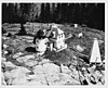
|
Vinalhaven (Penobscot Bay) |
44°01′30″N 68°51′44″W / 44.0251°N 68.8622°W | 1854 | 1984 | Active | Fifth-order Fresnel | 92 ft (28 m) |
| Indian Island Light | 
|
Rockport | 44°09′56″N 69°03′40″W / 44.1655°N 69.0610°W[19] | 1850 (Former) 1875 (Current) |
Never | 1934 | None | Unknown |
| Isle Au Haut Light | 
|
Isle au Haut | 44°03′53″N 68°39′05″W / 44.0647°N 68.6514°W | 1907 | 1934 | Active | 250mm | 48 ft (15 m) |
| Ladies Delight Light | 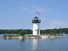
|
Winthrop, Maine (Lake Cobbosseecontee) |
1908 | 1930s | Active | Unknown | 25 ft (7.6 m) | |
| Libby Island Light | 
|
Machiasport (Machias Bay) |
44°34′06″N 67°22′03″W / 44.5683°N 67.3674°W | 1822 (Former) 1848 (Current) |
1974 | Active | VRB-25 | 91 ft (28 m) |
| Little River Light | 
|
Cutler | 44°39′03″N 67°11′32″W / 44.6509°N 67.1921°W | 1846 (Former) 1876 (Current) |
1975 | Active (Inactive: 1975–2001)[1] |
VRB-25 | 56 ft (17 m) |
| Lubec Channel Light | 
|
Lubec | 44°50′32″N 66°58′36″W / 44.8421°N 66.9766°W | 1890 | 1939 | Active | 155mm | 53 ft (16 m) |
| Machias Seal Island | Washington County, Maine (mouth of Bay of Fundy) |
44°30′06″N 67°06′06″W / 44.5018°N 67.1018°W | 1832 (Former) 1914 (Current) |
1995 | Active | Unknown | 65 ft (20 m) | |
| Marshall Point Light | 
|
Port Clyde | 43°55′03″N 69°15′41″W / 43.9174°N 69.2613°W | 1832 (Former) 1858 (Current) |
1980 | Active | 300mm | 30 ft (9.1 m) |
| Matinicus Rock Light | 
|
Matinicus Isle | 43°47′01″N 68°51′18″W / 43.7835°N 68.8550°W | 1827 (Former) 1846 (Current towers) |
1983 | 1924 (North tower) Active (South tower) |
VRB-25 | 90 ft (27 m) |
| Monhegan Island Light | 
|
Monhegan (Monhegan Island) |
43°45′53″N 69°18′57″W / 43.7648°N 69.3158°W | 1824 (Former) 1850 (Current) |
1959 | Active | VRB-25 | 178 ft (54 m) |
| Moose Peak Light | 
|
Mistake Island | 44°28′29″N 67°31′55″W / 44.4746°N 67.5320°W | 1827 (Former) 1851 (Current) |
1972 | Active | DCB-24 | 72 ft (22 m) |
| Mount Desert Light | 
|
Mount Desert Rock (Near Mount Desert Island) |
43°58′07″N 68°07′42″W / 43.9686°N 68.1283°W | 1830 (Former) 1847 (Current) |
1977 | Active | VRB-25 | 75 ft (23 m) |
| Narraguagus Light | 
|
Narraguagus Bay | 44°27′22″N 67°49′52″W / 44.456°N 67.8312°W[20] | 1853 | Never | 1934 | None | 54 ft (16 m)[21] |
| Nash Island Light | 
|
Pleasant Bay | 44°27′51″N 67°44′50″W / 44.4643°N 67.7473°W[22] | 1838 (Former) 1874 (Current) |
1958 | 1982 | None | 51 ft (16 m)[23] |
| Owls Head Light | 
|
Owls Head (Penobscot Bay) |
44°05′32″N 69°02′38″W / 44.0922°N 69.0440°W | 1825 | 1989 | Active | Fourth-order Fresnel | 100 ft (30 m) |
| Pemaquid Point Light | 
|
Bristol | 43°50′12″N 69°30′21″W / 43.8368°N 69.5058°W | 1827 (Former) 1857 (Current) |
1934 | Active | Fourth-order Fresnel | 79 ft (24 m) |
| Perkins Island Light | 
|
Georgetown (Perkins Island) |
43°47′12″N 69°47′07″W / 43.7868°N 69.7852°W | 1898 | 1959 | Active | 250mm | 41 ft (12 m) |
| Petit Manan Light | 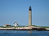
|
Milbridge (Petit Island) |
44°22′03″N 67°51′52″W / 44.3676°N 67.8644°W | 1817 (Former) 1855 (Current) |
1972 | Active | VRB-25 | 123 ft (37 m) |
| Pond Island Light | 
|
Kennebec River | 43°44′24″N 69°46′13″W / 43.7400°N 69.7703°W | 1821 (Former) 1855 (Current) |
1963 | Active | 250mm | 52 ft (16 m) |
| Portland Breakwater Light | 
|
South Portland | 43°39′20″N 70°14′06″W / 43.6555°N 70.2349°W | 1855 (Former) 1875 (Current) |
1934 | Active (Inactive: 1942–2002) |
Unknown | 30 ft (9.1 m) |
| Portland Head Light | 
|
Cape Elizabeth (Casco Bay) |
43°37′23″N 70°12′28″W / 43.6231°N 70.2079°W | 1791 | 1989 | Active | DCB-224 | 101 ft (31 m) |
| Prospect Harbor Point Light | 
|
Gouldsboro (Prospect Harbor) |
44°24′12″N 68°00′47″W / 44.4034°N 68.0130°W | 1850 (Former) 1891 (Current) |
1951 | Active | Optic | 42 ft (13 m) |
| Pumpkin Island Light | 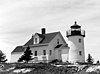
|
Deer Isle (Pumpkin Island) |
44°18′33″N 68°44′34″W / 44.3092°N 68.7428°W[24] | 1854 | Never | 1933 | None | Unknown |
| Ram Island Ledge Light | 
|
Cape Elizabeth (Casco Bay) |
43°37′53″N 70°11′15″W / 43.6315°N 70.1874°W | 1905 | 1959 | Active | Third-order Fresnel | 77 ft (23 m) |
| Ram Island Light | 
|
Boothbay Harbor | 43°48′14″N 69°35′57″W / 43.8038°N 69.5992°W | 1883 | 1965 | Active | Unknown | 36 ft (11 m) |
| Rockland Harbor Breakwater Light | 
|
Rockland | 44°06′14″N 69°04′39″W / 44.1040°N 69.0775°W | 1827 (Former) 1902 (Current) |
1964 | Active | VRB-25 | 39 ft (12 m) |
| Saddleback Ledge Light | 
|
Saddleback Ledge (Penobscot Bay) |
44°00′52″N 68°43′35″W / 44.0144°N 68.7264°W | 1839 | 1954 | Active | 300mm | 54 ft (16 m) |
| Saint Croix River Light | 
|
St. Croix River | 45°07′42″N 67°08′02″W / 45.1282°N 67.1338°W | 1857 (Former) 1976 (Current) |
1976 | Active | Unknown | 77 ft (23 m)[25] |
| Seguin Light | 
|
Georgetown | 43°42′27″N 69°45′29″W / 43.7075°N 69.7580°W | 1795 (Former) 1857 (Current) |
1985 | 2019 (Temporary)[26] |
First-order Fresnel | 180 ft (55 m) |
| Spring Point Ledge Light | 
|
South Portland | 43°39′08″N 70°13′26″W / 43.6521°N 70.2239°W | 1897 | 1934 | Active | Fifth-order Fresnel | 54 ft (16 m) |
| Squirrel Point Light | 
|
Arrowsic (Arrowsic Island) |
43°48′59″N 69°48′09″W / 43.8165°N 69.8024°W | 1898 | 1982 | Active | 250mm | 25 ft (7.6 m) |
| Tenants Harbor Light | 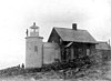
|
St. George (Southern Island) |
43°57′40″N 69°11′05″W / 43.9611°N 69.1848°W[27] | 1857 | Never | 1933 | None | 27 ft (8.2 m)[28] |
| Two Bush Island Light | 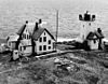
|
Two Bush Island (Penobscot Bay) |
43°57′51″N 69°04′26″W / 43.9642°N 69.0739°W | 1897 | 1964 | Active | VRB-25 | 65 ft (20 m) |
| West Quoddy Head Light | 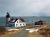
|
Lubec | 44°48′54″N 66°57′03″W / 44.8151°N 66.9507°W | 1808 (Former) 1858 (Current) |
1988 | Active | Third-order Fresnel | 83 ft (25 m) |
| Whaleback Light | 
|
Kittery (Piscataqua River) |
43°03′32″N 70°41′47″W / 43.0588°N 70.6963°W | 1820 (Former) 1872 (Current) |
1963 | Active | VLB-44 | 59 ft (18 m) |
| Whitehead Light | 
|
St. George (Whitehead Island) |
43°58′43″N 69°07′27″W / 43.9787°N 69.1243°W | 1807 (Former) 1857 (Current) |
1982 | Active | 300mm | 75 ft (23 m) |
| Whitlocks Mill Light | 
|
St. Croix River | 45°09′45″N 67°13′39″W / 45.1626°N 67.2274°W | 1892 (Former) 1910 (Current) |
1969 | Active | VLB-44 | 32 ft (9.8 m) |
| Winter Harbor Light | 
|
Winter Harbor | 44°21′41″N 68°05′15″W / 44.3614°N 68.0876°W[29] | 1856 | Never | 1933 | None | 37 ft (11 m)[29] |
| Wood Island Light | 
|
Biddeford (Biddeford Pool) |
43°27′25″N 70°19′45″W / 43.4569°N 70.3291°W | 1808 (Former) 1858 (Current) |
1986 | Active | VLB-44 | 71 ft (22 m) |
References edit
- ^ a b c "Historic Light Station Information and Photography: Maine". United States Coast Guard Historian's Office. Archived from the original on 2017-05-01.
- ^ a b Rowlett, Russ. "Lighthouses of the United States: Southern Maine". The Lighthouse Directory. University of North Carolina at Chapel Hill.
- ^ "Portland Head Light". Lighthouse Friends.
- ^ "Whitlocks Mill Light". LighthouseFriends.
- ^ "West Quoddy Head Light: History". Jeremy D'Entremont. 11 October 2023.
- ^ "Boon Island Light: History". Jeremy D'Entremont. 11 October 2023.
- ^ a b c d "Maine Lights Program: Overview and Conclusions" (PDF). Island Institute. January 2000. Archived from the original (PDF) on 2009-03-25. Retrieved 2012-08-28.
- ^ "Legendary Lighthouses: Maine Lights Program". PBS. Retrieved 27 August 2012.
- ^ "Tenants Harbor Light: History". Jeremy D'Entremont. 11 October 2023.
- ^ Light List, Volume I, Atlantic Coast, St. Croix River, Maine to Shrewsbury River, New Jersey (PDF). Light List. United States Coast Guard. 2012.
- ^ a b "Avery Rock Light". Jeremy D'Entremont. 11 October 2023.
- ^ Taken from NOAA chart 13316
- ^ estimated from Google Maps
- ^ "Crabtree Ledge Light". Jeremy D'Entremont. 11 October 2023.
- ^ a b "Crabtree Ledge Light: History". Jeremy D'Entremont. 11 October 2023.
- ^ "Dice Head Light: History". Jeremy D'Entremont. 11 October 2023.
- ^ "Grindel Point Light". LighthouseFriends.
- ^ "Hendricks Head Light". LighthouseFriends.
- ^ "Indian Island Light". LighthouseFriends.
- ^ "Narraguagus (Pond Island) Light". Lighthouse Friends.
- ^ "Narraguagus (Pond Island) Light: History". Jeremy D'Entremont. 11 October 2023.
- ^ "Nash Island Light". Lighthouse Friends.
- ^ "Nash Island Light". Jeremy D'Entremont. 11 October 2023.
- ^ "Pumpkin Island Light". Lighthouse Friends.
- ^ "St. Croix River Light". Jeremy D'Entremont. 11 October 2023.
- ^ "2020 Island Solar Powered now". 11 May 2019.
- ^ "Tenants Harbor, ME". LighthouseFriends.
- ^ "Tenants Harbor Light". Jeremy D'Entremont. 11 October 2023.
- ^ a b "Winter Harbor, ME". Lighthouse Friends.