


Summary
This is a list of all lighthouses in the U.S. state of Virginia as identified by the United States Coast Guard. There are nine active lights in the state as well as three automated caissons and eleven skeleton towers replacing previously staffed lights.
The first lighthouse in the state was erected in 1792 (the first Cape Henry Light) and it is the oldest surviving structure; the last, Chesapeake Light, was built in 1965 (ignoring automated towers erected later). The tallest extant tower is that at Cape Charles Light.
If not otherwise noted, focal height and coordinates are taken from the United States Coast Guard Light List,[1] while location and dates of activation, automation, and deactivation are taken from the United States Coast Guard Historical information site for lighthouses.[2] Locations of demolished lights have been estimated using National Oceanic and Atmospheric Administration (NOAA) navigational charts.
| Name | Image | Location | Coordinates | Year first lit | Automated | Year deactivated | Current Lens | Focal Height |
|---|---|---|---|---|---|---|---|---|
| Assateague Light | 
|
Assateague Island | 37°54′40″N 75°21′21″W / 37.9111°N 75.3558°W | 1833[3] (First) 1867[3] (Current) |
1933[3] | Active | DCB-24 | 154 ft (47 m)[4] |
| Back River Light | 
|
Hampton | 37°05′14″N 76°16′11″W / 37.0872°N 76.2698°W | 1829 | 1915 | 1936 (Destroyed in 1956) |
None | Unknown |
| Bells Rock Light | York River | 37°29′02″N 76°44′59″W / 37.4839°N 76.7498°W | 1881 | Never | 1928[4] (Dismantled) |
None | 40 ft (12 m)[4] | |
| Bowlers Rock Light | 
|
Rappahannock River | 37°49′28″N 76°43′58″W / 37.8245°N 76.7327°W | 1868[5] | Never | 1920[5] (Removed) |
None | Unknown |
| Cape Charles Light | 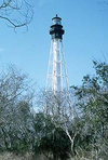
|
Cape Charles | 37°07′22″N 75°54′23″W / 37.1229°N 75.9063°W | 1828[6] (First) 1895[7] (Current) |
1963[7] | Active | 190mm | 180 ft (55 m)[4] |
| Cape Henry Light (Old) | 
|
Virginia Beach (Cape Henry) |
36°55′33″N 76°00′29″W / 36.9257°N 76.0081°W | 1792[8] | Never | 1881[8] | None | Unknown |
| Cape Henry Light (New) | 
|
Virginia Beach (Cape Henry) |
36°55′35″N 76°00′26″W / 36.9264°N 76.0072°W | 1881[9] | 1984[9] | Active | Unknown | 157 ft (48 m)[9] |
| Cherrystone Bar Light | 
|
Cape Charles (Offshore) |
37°15′23″N 76°01′57″W / 37.2564°N 76.0324°W | 1858[10] | Never | 1919[10] (Moved in 1920) |
None | Unknown |
| Chesapeake Light | Chesapeake Bay (Entrance) |
36°54′17″N 75°42′46″W / 36.90472°N 75.71278°W | 1965[11] | 1980[11] | 2016[12] | None | 117 ft (36 m) | |
| Craney Island Light | 
|
Elizabeth River (Mouth) |
36°53′31″N 76°20′13″W / 36.892°N 76.337°W | 1859[4] (First) 1884[4] (Last) |
Never | 1936[4] (Removed) |
None | 36 ft (11 m) |
| Deepwater Shoals Light | 
|
Newport News (Offshore) |
37°8′11.46″N 76°38′12.48″W / 37.1365167°N 76.6368000°W | 1855[13] (First) 1868[13] (Last) |
Never | 1936[13] (Demolished) |
None | 34 ft (10 m)[4] |
| Dutch Gap Canal Lights | James River | 37°22′35″N 77°21′34″W / 37.37639°N 77.35944°W | 1875[14] | Never | 1910[14] | None | 27 ft (8.2 m)[14] | |
| Great Wicomico River Light | Great Wicomico River (Mouth) |
37°48′15″N 76°16′03″W / 37.8042°N 76.2675°W | 1889[15] | Never | 1967[15] (Dismantled) |
None | 42 ft (13 m)[4] | |
| Hog Island Light (First tower) |
Exmore | 37°23′38″N 75°42′04″W / 37.394°N 75.701°W | 1853[16] | Never | 1896[17] (Replaced) |
None | Unknown | |
| Hog Island Light (Second tower) |
Exmore | 37°23′38″N 75°42′04″W / 37.394°N 75.701°W | 1896[16] | Never | 1948[17] (Demolished) |
None | Unknown | |
| Jones Point Light | 
|
Alexandria | 38°47′25.4″N 77°02′26.3″W / 38.790389°N 77.040639°W | 1856[18] | 1919[18] | Active[18] (Inactive: 1926–1995) |
Unknown | 35 ft (11 m)[18] |
| Jordan Point Front Range Light | None Known | James River | N/A | Unknown | Unknown | Unknown | None | Unknown |
| Jordan Point Range Rear Light | James River | 37°18′47″N 77°13′23″W / 37.313°N 77.223°W | 1855[19] (First) 1941 (Current) |
1941[19] | Active | Unknown | 35 ft (11 m) (Second tower) 65 ft (20 m) (Current tower) | |
| Killock Shoal Light | Chincoteague (Offshore) |
37°56′02″N 75°22′48″W / 37.934°N 75.380°W | 1886[20] | 1929 | 1939[20] (Dismantled) |
None | Unknown | |
| Lambert Point Light | Norfolk | 36°52′30″N 76°19′52″W / 36.875°N 76.331°W | 1872[21] | Never | 1892[21] (Collapsed in 1911) |
None | Unknown | |
| Nansemond River Light | 
|
Nansemond River (Mouth) |
36°54′43″N 76°26′42″W / 36.912°N 76.445°W | 1878[22] | Never | 1935[22] (Dismantled) |
None | Unknown |
| New Point Comfort Light | Chesapeake Bay | 36°54′43″N 76°26′42″W / 36.912°N 76.445°W | 1805[23] | 1930[23] | Active[24] (Inactive: 1963–1999[23]) |
250mm | 58 ft (18 m)[23] | |
| Newport News Middle Ground Light | 
|
Newport News | 36°56′43″N 76°23′29″W / 36.9452°N 76.3915°W | 1891[25] | 1954[25] | Active | VRB-25 | 52 ft (16 m)[4] |
| Old Plantation Flats Light | Cape Charles (Offshore) |
37°13′44″N 76°02′49″W / 37.2288°N 76.0469°W | 1886 | Never | 1962 (Demolished) |
None | 35 ft (11 m) | |
| Old Point Comfort Light | 
|
Hampton | 37°00′06″N 76°18′23″W / 37.0018°N 76.3064°W | 1804[26] | 1972 | Active | Fourth-order Fresnel[4] | 54 ft (16 m)[4] |
| Pages Rock Light | York River | 37°18′39″N 76°35′12″W / 37.3109°N 76.5866°W | 1893[27] | 1960[27] | 1967[27] (Dismantled) |
None | Unknown | |
| Point of Shoals Light | James River | 37°04′06″N 76°39′11″W / 37.0683°N 76.6530°W | 1855[28] (First) 1871[28] (Last) |
1932[28] | 1933[28] (Demolished) |
None | Unknown | |
| Pungoteague Creek Light | 
|
Chesapeake Bay | 37°39′47″N 75°53′53″W / 37.6630°N 75.8980°W | 1854[29] | Never | 1856[29] (Destroyed) |
None | Unknown |
| Smith Point Light | 
|
Potomac River (Mouth) |
37°52′48″N 76°11′02″W / 37.8800°N 76.1839°W | 1802[30] (First) 1897[30] (Current) |
1971[30] | Active | DCB-24[4] | 52 ft (16 m)[4] |
| Stingray Point Light | 
|
Rappahannock River (Mouth) |
37°33′41″N 76°16′12″W / 37.5613°N 76.2700°W | 1858[31] | 1950[32] | 1965[31] (Dismantled) |
None | 34 ft (10 m)[4] |
| Tangier Sound Light | 
|
Tangier (Offshore) |
37°47′16″N 75°58′26″W / 37.7878°N 75.9740°W | 1890 | Never | 1961 (Demolished) |
None | Unknown |
| Thimble Shoal Light | Chesapeake Bay | 37°00′53″N 76°14′24″W / 37.0146°N 76.2399°W | 1872[33] (First) 1914[33] (Current) |
1964[33] | Active | RB-355 | 55 ft (17 m)[33] | |
| Tue Marshes Light | 
|
York River (Mouth) |
37°14′08″N 76°23′09″W / 37.2356°N 76.3859°W | 1875[34] | Never | 1960[34] (Dismantled) |
None | Unknown |
| Watts Island Light | Chesapeake Bay | 37°46′55″N 75°53′38″W / 37.782°N 75.894°W | 1833[35] | 1923[35] | 1944[35] (Destroyed) |
None | Unknown | |
| White Shoal Light | James River | 37°01′18″N 76°31′39″W / 37.0218°N 76.5275°W | 1855[36] (First) 1871[36] (Last) |
Never | 1934[36] (Destroyed in the 1970s) |
None | Unknown | |
| Windmill Point Light | Rappahannock River (Mouth) |
37°35′48″N 76°14′09″W / 37.5968°N 76.2359°W | 1869[37] | 1954[37] | 1965[37] (Dismantled) |
None | Unknown | |
| Wolf Trap Light | 
|
Chesapeake Bay | 37°35′48″N 76°14′09″W / 37.5968°N 76.2359°W | 1870[38] (First) 1894[38] (Current) |
1971[38] | 2017[4] (Abandoned) |
VRB-25 | Unknown |
| York Spit Light | 
|
York River (Mouth) |
37°12′35″N 76°15′15″W / 37.2096°N 76.2542°W | 1870[39] | Never | 1960[39] (Dismantled) |
None | Unknown |
References edit
- ^ Light List, Volume II, Atlantic Coast, Shrewsbury River, New Jersey to Little River, South Carolina (PDF). Light List. United States Coast Guard. 2012.
- ^ "Historic Light Station Information and Photography: Virginia" (PDF). United States Coast Guard Historian's Office.
- ^ a b c "Assateague Lighthouse". Lighthousefriends.com. Retrieved October 17, 2017.
- ^ a b c d e f g h i j k l m n o p Rowlett, Russ. "Lighthouses of the United States: Virginia". The Lighthouse Directory. University of North Carolina at Chapel Hill. Retrieved October 17, 2017.
- ^ a b "Name: Bowlers Rock Light". Lighthouse Digest. Retrieved October 17, 2017.
- ^ Russ Rowlett. "Cape Charles Light Station, Virginia". University of North Carolina. Retrieved October 17, 2017.
- ^ a b "Cape Charles Lighthouse". Lighthousefriends.com. Retrieved October 17, 2017.
- ^ a b "Cape Henry (Old) Lighthouse". Lighthousefriends.com. Retrieved October 17, 2017.
- ^ a b c "Cape Henry (New) Lighthouse". Lighthousefriends.com. Retrieved October 17, 2017.
- ^ a b "Name: Cherrystone Bar Light". Lighthouse Digest. Retrieved October 17, 2017.
- ^ a b "Chesapeake Lighthouse". Lighthousefriends.com. Retrieved October 17, 2017.
- ^ "Station CHLV2 - Chesapeake Light, VA". NOAA. Retrieved October 17, 2017.
- ^ a b c "Deep Water Shoal Lighthouse". Chesapeake Chapter U.S.L.H.S. Retrieved October 17, 2017.
- ^ a b c "Dutch Gap Canal Lights". Chesapeake Chapter U.S.L.H.S. Retrieved October 17, 2017.
- ^ a b "Great Wicomico River". Chesapeake Chapter U.S.L.H.S. Retrieved October 17, 2017.
- ^ a b "Name: Hog Island Light (VA)". Lighthouse Digest. Retrieved October 18, 2017.
- ^ a b Jeremy D'Entremont. "Hog Island's First Order Lens Shines Again". Lighthouse Digest. Retrieved October 18, 2017.
- ^ a b c d "Jones Point Lighthouse". Lighthousefriends.com. Retrieved October 18, 2017.
- ^ a b "Jordan Point Lighthouse". Chesapeake Chapter U.S.L.H.S. Retrieved October 18, 2017.
- ^ a b "Killock Shoal". Chesapeake Chapter U.S.L.H.S. Retrieved October 18, 2017.
- ^ a b "Lamberts Point". Chesapeake Chapter U.S.L.H.S. Retrieved October 18, 2017.
- ^ a b "Nansemond River". Chesapeake Chapter U.S.L.H.S. Retrieved October 18, 2017.
- ^ a b c d "New Point Comfort Light Station Historical Documentation" (PDF). newpointcomfortlighthouse.org. Retrieved October 18, 2017.
- ^ "New Point Comfort Lighthouse". Lighthouse Friends. Retrieved October 18, 2017.
- ^ a b "Newport News Middle Ground Lighthouse". Lighthouse Friends. Retrieved October 18, 2017.
- ^ "Old Point Comfort Lighthouse". Lighthouse Friends. Retrieved October 19, 2017.
- ^ a b c "Pages Rock Lighthouse". Chesapeake Chapter U.S.L.H.S. Retrieved October 19, 2017.
- ^ a b c d "Point of Shoals". Chesapeake Chapter U.S.L.H.S. Retrieved October 19, 2017.
- ^ a b "Name: Pungoteague River Light". Lighthouse Digest. Retrieved October 19, 2017.
- ^ a b c "Smith Point Lighthouse". Lighthouse Friends. Retrieved October 19, 2017.
- ^ a b "Stingray Point". Chesapeake Chapter U.S.L.H.S. Retrieved October 19, 2017.
- ^ "Stingray Point (Replica) Lighthouse". Lighthouse Friends. Retrieved October 19, 2017.
- ^ a b c d "Thimble Shoal Lighthouse". Lighthouse Friends. Retrieved October 19, 2017.
- ^ a b "Tue Marshes Lighthouse". Chesapeake Chapter U.S.L.H.S. Retrieved October 19, 2017.
- ^ a b c "Watts Island". Chesapeake Chapter U.S.L.H.S. Retrieved October 19, 2017.
- ^ a b c "White Shoal". Chesapeake Chapter U.S.L.H.S. Retrieved October 19, 2017.
- ^ a b c "Windmill Point". Chesapeake Chapter U.S.L.H.S. Retrieved October 19, 2017.
- ^ a b c "Wolf Trap Lighthouse". Lighthouse Friends. Retrieved October 19, 2017.
- ^ a b "York Spit". Chesapeake Chapter U.S.L.H.S. Retrieved October 19, 2017.