
KNOWPIA
WELCOME TO KNOWPIA

List of locks and dams of the Upper Mississippi River 
Summary
This transport-related list is incomplete; you can help by adding missing items. (August 2008) |
This is a list of current and former locks and dams of the Upper Mississippi River which ends at the Mississippi River's confluence with the Ohio River at Cairo, Illinois.
 |
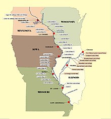 |
Locks and dams edit
| Name | Location | Miles above the Ohio | Coordinates | Pool elevation | Notes |
|---|---|---|---|---|---|
Minnesota edit | |||||
| Lake Itasca Stepping Stones / Dam | Itasca State Park | 47°14′23.2″N 95°12′27.6″W / 47.239778°N 95.207667°W | Lake Itasca 1,475 feet |
Stepping stones placed by CCC with creation of new channel / outlet for Mississippi | |
| Vekin's Dam | 8 miles north of Lake Itasca | 47°17′59.8″N 95°14′30.0″W / 47.299944°N 95.241667°W | n/a | Wooden dam from the late 1800s[1] | |
| Ottertail Power Co. Dam | 7 miles east of Bemidji | 47°29′1.0032″N 94°43′45.9156″W / 47.483612000°N 94.729421000°W | Lake Bemidji 1,335 feet |
||
| Knutson Dam | About 15 miles (24 km) east and north of city of Cass Lake | 47°27′07″N 94°29′00″W / 47.45194°N 94.48333°W | Cass Lake 1,301 feet |
||
| Winnibigoshish Lake Dam | About 15 miles (24 km) northwest of Deer River | 47°25′44.5″N 94°03′6.8″W / 47.429028°N 94.051889°W | Lake Winnibigoshish 1,290 feet |
Owned/operated by U.S. Army Corps of Engineers, Mississippi Valley Division, St. Paul District | |
| Pokegama Dam | Mile 1187 | 47°15′2.9844″N 93°35′15.5184″W / 47.250829000°N 93.587644000°W | Owned/operated by U.S. Army Corps of Engineers, Mississippi Valley Division, St. Paul District | ||
| Blandin Paper Co. Dam | Mile 1183.6 | 47°13′54.5628″N 93°31′52.9500″W / 47.231823000°N 93.531375000°W | |||
| Potlatch Dam | Brainerd, Minnesota | 46°22′40.8324″N 94°11′0.0816″W / 46.378009000°N 94.183356000°W | Rice Lake 1,174 Feet |
||
| Little Falls Dam | Little Falls, Minnesota | 45°58′32″N 94°22′06″W / 45.97556°N 94.36833°W | |||
| Blanchard Dam | Royalton, Minnesota | 45°51′39″N 94°21′36″W / 45.86083°N 94.36000°W | |||
| Sartell Dam | Sartell, Minnesota | 45°37′15″N 94°12′13″W / 45.62083°N 94.20361°W | |||
| St. Cloud Dam | St. Cloud, Minnesota | 45°32′52″N 94°08′50″W / 45.54778°N 94.14722°W | |||
| Coon Rapids Dam | Brooklyn Park / Coon Rapids, Minnesota | 45°08′36″N 93°18′43″W / 45.14333°N 93.31194°W | No locks, ends navigable portion of river | ||
| Upper Saint Anthony Falls Lock and Dam | Minneapolis, Minnesota | ~854 | 44°58′54″N 93°15′31″W / 44.98167°N 93.25861°W | 799 feet | Last lock upstream on river. Since June 9, 2015, the lock has remained closed to prevent the spread of invasive Asian Carp.[2] Located within the Mississippi National River and Recreation Area. |
| Lower Saint Anthony Falls Lock and Dam | Minneapolis, Minnesota | ~853 | 44°58′42″N 93°14′49″W / 44.97833°N 93.24694°W | 750 feet | Owned/operated by U.S. Army Corps of Engineers, Mississippi Valley Division, St. Paul District |
| Meeker Island Lock and Dam (demolished) |
Minneapolis, Minnesota / St. Paul, Minnesota | ~850 | 44°57′14″N 93°12′28″W / 44.95389°N 93.20778°W | NA | Demolished. Originally known as Lock and Dam No. 2 |
| Lock and Dam No. 1 | Minneapolis, Minnesota / St. Paul, Minnesota | ~847.8 | 44°54′55″N 93°12′02″W / 44.91528°N 93.20056°W | 725 feet | Ford Plant Powerhouse on east side. Owned/operated by U.S. Army Corps of Engineers, Mississippi Valley Division, St. Paul District |
| Lock and Dam No. 2 | Hastings, Minnesota | ~815 | 44°45′35″N 92°52′07″W / 44.75972°N 92.86861°W | 687 feet | Owned/operated by U.S. Army Corps of Engineers, Mississippi Valley Division, St. Paul District |
Minnesota–Wisconsin edit | |||||
| Lock and Dam No. 3 | Red Wing, Minnesota | 796.9 | 44°36′36″N 92°36′37″W / 44.61000°N 92.61028°W | 675 feet | Owned/operated by U.S. Army Corps of Engineers, Mississippi Valley Division, St. Paul District |
| Lock and Dam No. 4 | Alma, Wisconsin | ~753 | 44°19′32″N 91°55′13″W / 44.32556°N 91.92028°W | 667 feet | The lock is on the Wisconsin side right next to a small cafe. Owned/operated by U.S. Army Corps of Engineers, Mississippi Valley Division, St. Paul District |
| Lock and Dam No. 5 | Winona County, Minnesota | ~738.1 | 44°09′40″N 91°48′39″W / 44.16111°N 91.81083°W | 660 feet | Visitor parking next to the lock. Owned/operated by U.S. Army Corps of Engineers, Mississippi Valley Division, St. Paul District |
| Lock and Dam No. 5A | Goodview, Minnesota | ~728.5 | 44°05′18″N 91°40′08″W / 44.08833°N 91.66889°W | 651 feet | Owned/operated by U.S. Army Corps of Engineers, Mississippi Valley Division, St. Paul District |
| Lock and Dam No. 6 | Trempealeau, Wisconsin | ~714.1 | 43°59′59″N 91°26′18″W / 43.99972°N 91.43833°W | 646 feet | Owned/operated by U.S. Army Corps of Engineers, Mississippi Valley Division, St. Paul District |
| Lock and Dam No. 7 | La Crescent, Minnesota | ~702.5 | 43°52′01″N 91°18′26″W / 43.86694°N 91.30722°W | 639 feet | Adjacent to I-90 Mississippi River Bridge. Visitor parking and information next to the lock. Owned/operated by U.S. Army Corps of Engineers, Mississippi Valley Division, St. Paul District |
| Lock and Dam No. 8 | Genoa, Wisconsin | ~679.2 | 43°34′12″N 91°13′54″W / 43.57000°N 91.23167°W | 631 feet | Visitor parking right next to the lock. Owned/operated by U.S. Army Corps of Engineers, Mississippi Valley Division, St. Paul District |
Iowa–Wisconsin edit | |||||
| Lock and Dam No. 9 | Harpers Ferry, Iowa | ~647.9 | 43°12′46″N 91°06′15″W / 43.21278°N 91.10417°W | 620 feet | Parking area next to lock on Wisconsin side. Owned/operated by U.S. Army Corps of Engineers, Mississippi Valley Division, St. Paul District |
| Lock and Dam No. 10 | Guttenberg, Iowa | ~615.0 | 42°47′06″N 91°05′42″W / 42.78500°N 91.09500°W | 611 feet | Owned/operated by U.S. Army Corps of Engineers, Mississippi Valley Division, St. Paul District |
| Lock and Dam No. 11 | Dubuque, Iowa | ~583 | 42°32′25″N 90°38′39″W / 42.54028°N 90.64417°W | 603 feet | Owned/operated by U.S. Army Corps of Engineers, Mississippi Valley Division, Rock Island District |
Iowa–Illinois edit | |||||
| Lock and Dam No. 12 | Bellevue, Iowa | ~556.7 | 42°15′41″N 90°25′12″W / 42.26139°N 90.42000°W | 592 feet | Owned/operated by U.S. Army Corps of Engineers, Mississippi Valley Division, Rock Island District |
| Lock and Dam No. 13 | Fulton, IL | ~522.5 | 41°53′53″N 90°09′21″W / 41.89806°N 90.15583°W | 583 feet | Owned/operated by U.S. Army Corps of Engineers, Mississippi Valley Division, Rock Island District |
| Lock and Dam No. 14 | LeClaire, Iowa | ~493.2 | 41°34′24″N 90°23′56″W / 41.57333°N 90.39889°W | 572 feet | Owned/operated by U.S. Army Corps of Engineers, Mississippi Valley Division, Rock Island District |
| Lock and Dam No. 15 | Rock Island, Illinois | ~482.8 | 41°31′07″N 90°34′08″W / 41.51861°N 90.56889°W | 561 feet | Owned/operated by U.S. Army Corps of Engineers, Mississippi Valley Division, Rock Island District |
| Lock and Dam No. 16 | Muscatine, Iowa | ~457.2 | 41°25′32″N 91°0′35″W / 41.42556°N 91.00972°W | 545 feet | Owned/operated by U.S. Army Corps of Engineers, Mississippi Valley Division, Rock Island District |
| Lock and Dam No. 17 | New Boston, Illinois | ~437 | 41°11′27″N 91°03′37″W / 41.19083°N 91.06028°W | 536 feet | Owned/operated by U.S. Army Corps of Engineers, Mississippi Valley Division, Rock Island District |
| Lock and Dam No. 18 | Gladstone, Illinois | ~410.5 | 40°52′54″N 91°01′27″W / 40.88167°N 91.02417°W | 528 feet | Owned/operated by U.S. Army Corps of Engineers, Mississippi Valley Division, Rock Island District |
| Lock and Dam No. 19 | Keokuk, Iowa | ~364 | 40°23′41″N 91°22′29″W / 40.39472°N 91.37472°W | 518 feet | Owned/operated by U.S. Army Corps of Engineers, Mississippi Valley Division, Rock Island District |
Missouri–Illinois edit | |||||
| Lock and Dam No. 20 | Canton, Missouri | ~343 | 40°08′37″N 91°30′46″W / 40.14361°N 91.51278°W | 480 feet | Owned/operated by U.S. Army Corps of Engineers, Mississippi Valley Division, Rock Island District |
| Lock and Dam No. 21 | Quincy, Illinois | ~324.9 | 39°54′23″N 91°25′56″W / 39.90639°N 91.43222°W | 470 feet | Owned/operated by U.S. Army Corps of Engineers, Mississippi Valley Division, Rock Island District |
| Lock and Dam No. 22 | Saverton, Missouri | ~301.2 | 39°38′18″N 91°14′49″W / 39.63833°N 91.24694°W | 460 feet | Owned/operated by U.S. Army Corps of Engineers, Mississippi Valley Division, Rock Island District |
| Lock and Dam No. 24 | Clarksville, Missouri | ~273.4 | 39°22′36″N 90°54′30″W / 39.37667°N 90.90833°W | 449 feet | Owned/operated by U.S. Army Corps of Engineers, Mississippi Valley Division, St. Louis District |
| Lock and Dam No. 25 | Winfield, Missouri | ~241.4 | 39°00′17″N 90°41′11″W / 39.00472°N 90.68639°W | 434 feet | Owned/operated by U.S. Army Corps of Engineers, Mississippi Valley Division, St. Louis District |
| Lock and Dam No. 26 (historical) | Alton, Illinois | ~202.5 | 38°53′10″N 90°10′55″W / 38.88611°N 90.18194°W | 419 feet | Demolished, replaced by Melvin Price Locks and Dam. |
| Melvin Price Locks and Dam aka Lock and Dam No. 26 |
East Alton, Illinois | ~200.8 | 38°52′09″N 90°09′13″W / 38.86917°N 90.15361°W | Owned/operated by U.S. Army Corps of Engineers, Mississippi Valley Division, St. Louis District | |
| Chain of Rocks Dam aka Dam No. 27 |
Glasgow Village, Missouri | ~190.2 | 38°45′27″N 90°10′39″W / 38.75750°N 90.17750°W | 398 feet | Owned/operated by U.S. Army Corps of Engineers, Mississippi Valley Division, St. Louis District |
| Chain of Rocks Lock aka Lock No. 27 |
Granite City, Illinois | 38°42′11″N 90°10′51″W / 38.70306°N 90.18083°W | Owned/operated by U.S. Army Corps of Engineers, Mississippi Valley Division, St. Louis District | ||
Expansion proposals for upper Mississippi locks edit
The Army Corps of Engineers has studied the expansion of some locks on the Upper Mississippi.[3] Since at least 1999, the Corps has considered expanding 600 ft locks 20, 21, 22, 24, and 25 to 1,200 ft.[3][4]
- Gallery
-
 The inland and intercoastal waterways, with the Upper Mississippi highlighted in red.
 -
 Upper Mississippi River Stairway of Water.
 -
 Upper Mississippi locks expansion study
 -
Lock and Dam 6 time lapse


See also edit
References edit
- ^ Weeks, John. "Vekins Dam". Retrieved May 3, 2022.
- ^ Sepic, Matt. "End of an era: Upper St. Anthony Falls lock closes". MPR News. Retrieved 24 June 2015.
- ^ a b "Big Price - Little Benefit (The case against lock expansion on the Mississippi River)" (PDF). Nicollet Island Coalition. February 2010.
- ^ "Lock System Expansion Proposal is Aired". Milwaukee Journal Sentinel. Associated Press. August 8, 1999.
External links edit
- USACE St. Paul District Locks and Dams
- Historic American Engineering Record (HAER) historical overviews:
- HAER No. MN-20, "Upper Mississippi River 9-Foot Channel Project History, Mississippi River between Minneapolis & Guttenberg, IA, Red Wing vicinity, Goodhue County, MN", 48 data pages (Lock & Dam Nos. 3–10)
- HAER No. IA-33, "Upper Mississippi River 9-Foot Channel Project, Lock & Dams 11-22, Dubuque, Dubuque County, IA", 103 data pages
- HAER No. MO-50, "Upper Mississippi River Nine-Foot Channel Project, Lock & Dam Nos. 24-27, Clarksville, Pike County, MO", 125 data pages
- HAER documentation of individual locks and dams:
- HAER No. MN-21, "Upper Mississippi River 9-Foot Channel Project, Lock & Dam No. 3, Red Wing, Goodhue County, MN", 98 photos, 11 data pages, 7 photo caption pages
- HAER No. MN-22, "Upper Mississippi River 9-Foot Channel Project, Lock & Dam No. 5, Minneiska, Winona County, MN", 92 photos, 11 data pages, 6 photo caption pages
- HAER No. MN-23, "Upper Mississippi River 9-Foot Channel Project, Lock & Dam No. 5A, Winona, Winona County, MN", 103 photos, 10 data pages, 7 photo caption pages
- HAER No. MN-24, "Upper Mississippi River 9-Foot Channel Project, Lock & Dam No. 7, Dresbach, Winona County, MN", 76 photos, 9 data pages, 5 photo caption pages
- HAER No. MN-62, "Mississippi River 9-Foot Channel, Lock & Dam No. 1, Saint Paul, Ramsey County, MN", 30 photos, 47 data pages, 3 photo caption pages
- HAER No. IA-22, "Upper Mississippi River 9-Foot Channel, Lock & Dam No. 10, Guttenberg, Clayton County, IA", 114 photos, 11 data pages, 8 photo caption pages
- HAER No. IA-23, "Mississippi River 9-Foot Channel Project, Lock & Dam No. 11, Dubuque, Dubuque County, IA", 50 photos, 16 data pages, 3 photo caption pages
- HAER No. IA-24, "Mississippi River 9-Foot Channel Project, Lock & Dam No. 12, Bellevue, Jackson County, IA", 23 photos, 14 data pages, 2 photo caption pages
- HAER No. IA-25, "Mississippi River 9-Foot Channel, Lock & Dam No. 14, Le Claire, Scott County, IA", 54 photos, 17 data pages, 4 photo caption pages
- HAER No. IA-26, "Mississippi River 9-Foot Channel Project, Lock & Dam No. 16, Muscatine, Muscatine County, IA", 21 photos, 13 data pages, 2 photo caption pages
- HAER No. IA-27, "Mississippi River 9-Foot Channel, Lock & Dam No. 19, Keokuk, Lee County, IA", 79 photos, 17 data pages, 5 photo caption pages
- HAER No. IL-26, "Mississippi River 9-Foot Channel Project, Lock & Dam No. 13, Fulton, Whiteside County, IL", 14 photos, 16 data pages, 2 photo caption pages
- HAER No. IL-27, "Mississippi River 9-Foot Channel Project, Lock & Dam No. 15, Rock Island, Rock Island County, IL", 52 photos, 16 data pages, 4 photo caption pages
- HAER No. IL-28, "Mississippi River 9-Foot Channel Project, Lock & Dam No. 17, New Boston, Mercer County, IL", 78 photos, 14 data pages, 5 photo caption pages
- HAER No. IL-29, "Mississippi River 9-Foot Channel Project, Lock & Dam No. 18, Gladstone, Henderson County, IL", 18 photos, 15 data pages, 2 photo caption pages
- HAER No. IL-30, "Mississippi River 9-Foot Channel Project, Lock & Dam No. 21, Quincy, Adams County, IL", 27 photos, 15 data pages, 2 photo caption pages
- HAER No. IL-31, "Upper Mississippi River 9-Foot Channel Project, Lock & Dam 26, Alton, Madison County, IL", 81 photos, 10 data pages, 6 photo caption pages
- HAER No. IL-32, "Upper Mississippi River 9-Foot Channel Project, Lock & Dam 26R, Alton, Madison County, IL", 59 photos, 9 data pages, 5 photo caption pages
- HAER No. IL-33, "Upper Mississippi River 9-Foot Channel Project, Lock & Dam 27, Granite City, Madison County, IL", 92 photos, 10 data pages, 7 photo caption pages
- HAER No. MO-34, "Upper Mississippi River Nine-Foot Channel Project, Lock & Dam Complex No. 20, Canton, Lewis County, MO", 33 photos, 18 data pages, 2 photo caption pages
- HAER No. MO-35, "Upper Mississippi River Nine-Foot Channel Project, Lock & Dam Complex No. 22, Saverton, Ralls County, MO", 21 photos, 15 data pages, 2 photo caption pages
- HAER No. MO-36, "Upper Mississippi River Nine-Foot Channel Project, Lock & Dam No. 24, Clarksville, Pike County, MO", 44 photos, 9 data pages, 3 photo caption pages
- HAER No. MO-37, "Upper Mississippi River Nine-Foot Channel Project, Lock & Dam No. 25, Cap au Gris, Lincoln County, MO", 93 photos, 9 data pages, 7 photo caption pages
- HAER No. WI-47, "Upper Mississippi River 9-Foot Channel, Lock & Dam No. 4, Alma, Buffalo County, WI", 118 photos, 12 data pages, 7 photo caption pages
- HAER No. WI-48, "Upper Mississippi River 9-Foot Channel, Lock & Dam No. 6, Trempealeau, Trempealeau County, WI", 79 photos, 9 data pages, 5 photo caption pages
- HAER No. WI-49, "Upper Mississippi River 9-Foot Channel, Lock & Dam No. 8, Genoa, Vernon County, WI", 120 photos, 10 data pages, 9 photo caption pages
- HAER No. WI-50, "Upper Mississippi River 9-Foot Channel, Lock & Dam No. 9, Lynxville, Crawford County, WI", 83 photos, 12 data pages, 6 photo caption pages