
KNOWPIA
WELCOME TO KNOWPIA

List of national parks of Finland 
Summary
There are 41 national parks in Finland. They are all managed by the Metsähallitus. The national parks cover a total area of 9,892 square kilometres (3,819 sq mi) – 2.7% of Finland's total land area.
A total of 3.2 million people visited the parks in 2018.[1] During the COVID-19 pandemic, the number of national park visitors strongly increased, with a total of 8.5 million people visiting the parks in 2021.[2]

List of national parks edit
| National park | Photo | Region | Land area (km2) | Established | Visitation (2021)[3] | Coordinates |
|---|---|---|---|---|---|---|
| Archipelago | 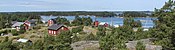
|
Southwest Finland | 500 | 1982 | 84,000 | 59°54′53″N 21°52′39″E / 59.91472°N 21.87750°E |
| Bothnian Bay | 
|
Lapland | 2.5 | 1991 | 6,300 | 65°37′N 024°19′E / 65.617°N 24.317°E |
| Teijo | 
|
Southwest Finland | 33.85 | 2015 | 104,700 | 60°13′26″N 022°57′37″E / 60.22389°N 22.96028°E |
| Salla | 
|
Lapland | 99.83 | 2022 | ||
| Bothnian Sea | 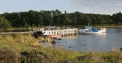
|
Southwest Finland & Satakunta | 913 | 2011 | 95,300 | 61°32′06″N 21°33′50″E / 61.53500°N 21.56389°E |
| Eastern Gulf of Finland | 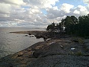
|
Kymenlaakso | 6.7 | 1982 | 16,300 | 60°17′5″N 27°16′26″E / 60.28472°N 27.27389°E |
| Ekenäs Archipelago | 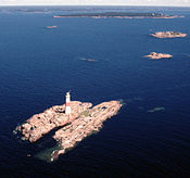
|
Uusimaa | 52 | 1989 | 59,400 | 59°49′22″N 23°27′15″E / 59.82278°N 23.45417°E |
| Helvetinjärvi | 
|
Pirkanmaa | 49.8 | 1982 | 67,000 | 62°2′N 23°51′E / 62.033°N 23.850°E |
| Hiidenportti | 
|
Kainuu | 45 | 1982 | 15,000 | 63°52′22″N 29°3′31″E / 63.87278°N 29.05861°E |
| Hossa | 
|
Kainuu | 11 | 2017 | 112,900 | 65°29′23″N 29°19′25″E / 65.48972°N 29.32361°E |
| Isojärvi | 
|
Central Finland | 19 | 1982 | 30,200 | 61°41′54″N 25°0′39″E / 61.69833°N 25.01083°E |
| Kauhaneva-Pohjankangas | 
|
Southern Ostrobothnia / Satakunta | 57 | 1982 | 29,700 | 62°10′45″N 22°24′23″E / 62.17917°N 22.40639°E |
| Koli | 
|
North Karelia | 30 | 1991 | 256,900 | 63°3′27″N 29°53′14″E / 63.05750°N 29.88722°E |
| Kolovesi | 
|
Southern Savonia | 23 | 1990 | 17,200 | 62°15′27″N 28°49′0″E / 62.25750°N 28.81667°E |
| Southern Konnevesi | 
|
Central Finland / Northern Savonia | 15.44 | 2014 | 38,600 | 62°33′30″N 26°38′50″E / 62.55833°N 26.64722°E |
| Kurjenrahka | 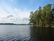
|
Southwest Finland | 29 | 1998 | 77,600 | 60°43′14″N 22°23′1″E / 60.72056°N 22.38361°E |
| Lauhanvuori | 
|
Southern Ostrobothnia | 53 | 1982 | 20,500 | 62°09′7″N 22°10′30″E / 62.15194°N 22.17500°E |
| Leivonmäki | 
|
Central Finland | 29 | 2003 | 33,400 | 61°56′N 26°2′E / 61.933°N 26.033°E |
| Lemmenjoki | 
|
Lapland | 2,850 | 1956 | 29,500 | 68°30′N 25°30′E / 68.500°N 25.500°E |
| Liesjärvi | 
|
Tavastia Proper | 22 | 1956 | 60,100 | 60°40′50″N 23°51′30″E / 60.68056°N 23.85833°E |
| Linnansaari | 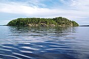
|
Southern Savonia / Northern Savonia | 38 | 1956 | 36,000 | 62°6′38″N 28°30′34″E / 62.11056°N 28.50944°E |
| Nuuksio | 
|
Uusimaa | 45 | 1994 | 314,500 | 60°18′27″N 24°29′57″E / 60.30750°N 24.49917°E |
| Oulanka | 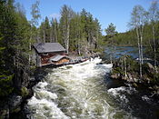
|
Northern Ostrobothnia / Lapland | 270 | 1956 | 253,300 | 66°22′32″N 29°20′19″E / 66.37556°N 29.33861°E |
| Päijänne | 
|
Päijänne Tavastia | 14 | 1993 | 15,000 | 61°23′12″N 25°23′36″E / 61.38667°N 25.39333°E |
| Pallas-Yllästunturi | 
|
Lapland | 1,020 | 2005 | 699,200 | 68°9′32″N 24°2′25″E / 68.15889°N 24.04028°E |
| Patvinsuo | 
|
North Karelia | 105 | 1982 | 20,200 | 63°6′41″N 30°42′16″E / 63.11139°N 30.70444°E |
| Petkeljärvi | 
|
North Karelia | 6 | 1956 | 29,800 | 62°35′N 31°11′E / 62.583°N 31.183°E |
| Puurijärvi-Isosuo | 
|
Pirkanmaa / Satakunta | 27 | 1993 | 21,700 | 61°14′57″N 22°34′1″E / 61.24917°N 22.56694°E |
| Pyhä-Häkki | 
|
Central Finland | 13 | 1956 | 21,400 | 62°50′44″N 25°28′21″E / 62.84556°N 25.47250°E |
| Pyhä-Luosto | 
|
Lapland | 142 | 2005 | 232,700 | 67°3′59″N 26°58′25″E / 67.06639°N 26.97361°E |
| Repovesi | 
|
Kymenlaakso / Southern Savonia | 15 | 2003 | 172,900 | 61°11′N 26°53′E / 61.183°N 26.883°E |
| Riisitunturi | 
|
Lapland | 77 | 1982 | 89,900 | 66°14′N 28°30′E / 66.233°N 28.500°E |
| Rokua | 
|
Northern Ostrobothnia / Kainuu | 4.3 | 1956 | 62,600 | 64°33′22″N 26°30′36″E / 64.55611°N 26.51000°E |
| Salamajärvi | 
|
Central Ostrobothnia / Central Finland | 62 | 1982 | 22,400 | 63°16′N 24°45′E / 63.267°N 24.750°E |
| Seitseminen | 
|
Pirkanmaa | 45.5 | 1982 | 48,200 | 61°56′N 23°26′E / 61.933°N 23.433°E |
| Sipoonkorpi | 
|
Uusimaa | 18.6 | 2011 | 146,400 | 60°18′54″N 25°13′8″E / 60.31500°N 25.21889°E |
| Syöte | 
|
Northern Ostrobothnia / Lapland | 299 | 2000 | 117,800 | 65°44′51″N 27°54′43″E / 65.74750°N 27.91194°E |
| Tiilikkajärvi | 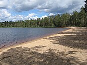
|
Northern Savonia / Kainuu | 34 | 1982 | 25,300 | 63°40′N 28°18′E / 63.667°N 28.300°E |
| Torronsuo | 
|
Tavastia Proper | 25.5 | 1990 | 55,500 | 60°44′N 23°37′E / 60.733°N 23.617°E |
| Urho Kekkonen | 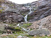
|
Lapland | 2,550 | 1983 | 446,300 | 68°13′5″N 28°8′25″E / 68.21806°N 28.14028°E |
| Valkmusa | 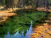
|
Kymenlaakso | 17 | 1996 | 25,400 | 60°34′N 26°44′E / 60.567°N 26.733°E |
See also edit
Other references on Wikipedia:
References edit
- ^ "The economic and health impacts of Finnish national parks increased in 2018 – positive development at risk without increase in funding". Metsähallitus. 2019-01-31. Archived from the original on 2019-04-22. Retrieved January 31, 2019.
- ^ "Käyntimäärät Maastossa". metsa.fi (in Finnish). Archived from the original on 16 December 2021. Retrieved 23 June 2022.
- ^ "Käyntimäärät Maastossa". metsa.fi (in Finnish). Archived from the original on 16 December 2021. Retrieved 23 June 2022.
External links edit
Wikivoyage has a travel guide for Finnish National Parks.
- Finland's National Parks
- National parks, hiking areas, wilderness areas
- I left my heart in Lapland, thisisFINLAND by Ministry for Foreign Affairs of Finland