
KNOWPIA
WELCOME TO KNOWPIA

List of ports and harbors of the Arctic Ocean 
Summary
This is a list of ports and harbors of the Arctic Ocean. The entries are sorted travelling east from the International Date Line.
North America edit
United States edit
| Location | State | Water body | Coordinates | Features & notes[1] | Image |
|---|---|---|---|---|---|
| Kivilina | Alaska | Chukchi Sea | 67°43′38″N 164°32′21″W / 67.72722°N 164.53917°W | US rank:86[2] | 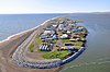
|
| Utqiaġvik | Alaska | Chukchi Sea | 71°17′26″N 156°47′19″W / 71.29056°N 156.78861°W | 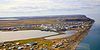
| |
| Prudhoe Bay | Alaska | Beaufort Sea | 70°19′32″N 148°42′41″W / 70.32556°N 148.71139°W | 
|
Canada edit
| Location | Province / Territory | Water body | Coordinates | Features & notes[1] | Image |
|---|---|---|---|---|---|
| Tuktoyaktuk | Northwest Territories | Beaufort Sea | 69°27′03″N 133°02′09″W / 69.45083°N 133.03583°W[3] | Port Brabant to 1950[4] | 
|
| Port of Churchill | Manitoba | Hudson Bay | 58°46′45″N 94°11′36″W / 58.77917°N 94.19333°W[5] | 
| |
| Iqaluit | Nunavut | Frobisher Bay | 63°44′58″N 68°31′18″W / 63.74944°N 68.52167°W[6] | Opened 25 July 2023[7] | 
|
Greenland edit
| Location | Municipality | Water body | Coordinates | Features & notes[1] | Image |
|---|---|---|---|---|---|
| Nuuk Port and Harbour | Sermersooq | Labrador Sea | 64°10′15″N 51°43′15″W / 64.17083°N 51.72083°W | ||
| Port of Ilulissat | Avannaata | Disko Bay | 69°13′19″N 51°05′42″W / 69.22194°N 51.09500°W | 
|
Europe edit
Iceland edit
| Location | Regions | Water body | Coordinates | Features & notes | Image |
|---|---|---|---|---|---|
| Akureyri | Northeastern | Eyjafjörður | 65°41′00″N 18°06′00″W / 65.68333°N 18.10000°W | 
|
Norway edit
| Location | County | Water body | Coordinates | Features & notes | Image |
|---|---|---|---|---|---|
| Tromsø | Troms | Grøtsundet | 69°40′58″N 18°56′34″E / 69.68278°N 18.94278°E | 
| |
| Hammerfest | Finnmark | Barents Sea | 70°39′48″N 23°40′56″E / 70.66333°N 23.68222°E | 
| |
| Honningsvåg | Finnmark | Barents Sea | 70°58′43″N 25°58′36″E / 70.97861°N 25.97667°E | 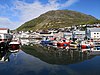
| |
| Kirkenes | Finnmark | Varangerfjord | 69°43′37″N 30°02′44″E / 69.72694°N 30.04556°E | 
| |
| Vardø | Finnmark | Barents Sea | 70°22′13″N 31°06′38″E / 70.37028°N 31.11056°E | 
|
Russia edit
| Location | Federal subject | Water body | Coordinates | Features & notes | Image |
|---|---|---|---|---|---|
| Vitino | Murmansk Oblast | Kandalaksha Gulf | 67°05′00″N 32°20′00″E / 67.08333°N 32.33333°E | ||
| Kandalaksha | Murmansk Oblast | White Sea | 67°09′25″N 32°24′42″E / 67.15694°N 32.41167°E | 
| |
| Port of Murmansk | Murmansk Oblast | Barents Sea | 68°58′48″N 33°03′22″E / 68.98000°N 33.05611°E | 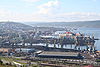
| |
| Severomorsk | Murmansk Oblast | Barents Sea | 69°04′00″N 33°25′00″E / 69.06667°N 33.41667°E | 
| |
| Belomorsk | Republic of Karelia | Onega Bay | 64°31′31″N 34°45′57″E / 64.52528°N 34.76583°E | 
| |
| Port of Arkhangelsk | Arkhangelsk Oblast | Northern Dvina | 64°32′00″N 40°30′00″E / 64.53333°N 40.50000°E | 
| |
| Naryan-Mar | Nenets Autonomous Okrug | Pechora River | 67°38′00″N 53°03′00″E / 67.63333°N 53.05000°E | 
| |
| Sabetta | Yamalo-Nenets Autonomous Okrug | Kara Sea | 71°16′24″N 72°04′21″E / 71.27333°N 72.07250°E | 
| |
| Dudinka | Krasnoyarsk Krai| | Yenisey | 69°24′23″N 86°10′35″E / 69.40639°N 86.17639°E | 
| |
| Dikson | Krasnoyarsk Krai | Kara Sea | 73°30′00″N 80°31′00″E / 73.50000°N 80.51667°E | 
| |
| Igarka | Krasnoyarsk Krai | Yenisey | 67°28′00″N 86°35′00″E / 67.46667°N 86.58333°E | 
| |
| Tiksi | Sakha Republic | Laptev Sea | 71°39′00″N 128°52′00″E / 71.65000°N 128.86667°E | 
| |
| Port of Pevek | Chukotka Autonomous Okrug | Chaunskaya Bay | 69°42′17″N 170°15′49″E / 69.70472°N 170.26361°E | 
|
References edit
- ^ a b c Seasonal, will freeze over during the winter.
- ^ Port rankings by tonnage from [AAPA website], accessed 2 October 2012
- ^ "Tuktoyaktuk". Geographical Names Data Base. Natural Resources Canada.
- ^ "Hamlet of Tuktoyaktuk". Retrieved 4 April 2024.
- ^ "Churchill Harbour". Geographical Names Data Base. Natural Resources Canada.
- ^ "Iqaluit". Geographical Names Data Base. Natural Resources Canada.
- ^ "Iqaluit Deep Sea Port Officially Opens". 25 July 2023. Retrieved 4 April 2024.