


Summary
The surface of Mars has been divided into thirty cartographic quadrangles by the United States Geological Survey. Each quadrangle is a region covering a specified range of latitudes and longitudes on the Martian surface. The quadrangles are named after classical albedo features, and they are numbered from one to thirty with the prefix "MC" (for "Mars Chart"),[1] with the numbering running from north to south and from west to east.

The quadrangles appear as rectangles on maps based on a cylindrical map projection,[1] but their actual shapes on the curved surface of Mars are more complicated Saccheri quadrilaterals. The sixteen equatorial quadrangles are the smallest, with surface areas of 4,500,000 square kilometres (1,700,000 sq mi) each, while the twelve mid-latitude quadrangles each cover 4,900,000 square kilometres (1,900,000 sq mi). The two polar quadrangles are the largest, with surface areas of 6,800,000 square kilometres (2,600,000 sq mi) each.[2][3]
History edit
In 1972, NASA's Mariner 9 mission returned thousands of photographs collectively covering more than 80% of the Martian surface. That year and the next, NASA's Jet Propulsion Laboratory collaborated with the United States Geological Survey's Astrogeology Research Program to assemble Mariner's photographs into the first detailed photomosaic maps of Mars. To organize and subdivide this work, the USGS divided the planet's surface into thirty cartographic quadrangles, each named for classical albedo features within the respective regions, and the various quadrangles were assigned to geologists at USGS and at American universities for mapping and study.[4]
As continuing missions to Mars have made increasingly accurate maps available, the International Astronomical Union has assigned names to regions of the planet's surface that reflect its actual surface features and geology. These names are also broadly inspired by classical albedo features, with the result that they generally correspond to the names of the arbitrary USGS quadrangles, though larger IAU features frequently span multiple quadrangles.[2]
Quadrangles edit
The maps below were produced by the Mars Global Surveyor's Mars Orbiter Laser Altimeter; redder colors indicate higher elevations. The maps of the equatorial quadrangles use a Mercator projection, while those of the mid-latitude quadrangles use a Lambert conformal conic projection, and the maps of the polar quadrangles use a polar stereographic projection.[1]
| Number | Name | Latitudes | Longitudes | Features | Map |
|---|---|---|---|---|---|
| MC-01 | Mare Boreum | 65–90° N | 180° W – 180° E | Features | 
|
| MC-02 | Diacria | 30–65° N | 120–180° W | Features | 
|
| MC-03 | Arcadia | 30–65° N | 60–120° W | Features | 
|
| MC-04 | Mare Acidalium | 30–65° N | 0–60° W | Features | 
|
| MC-05 | Ismenius Lacus | 30–65° N | 0–60° E | Features | 
|
| MC-06 | Casius | 30–65° N | 60–120° E | Features | 
|
| MC-07 | Cebrenia | 30–65° N | 120–180° E | Features | 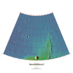
|
| MC-08 | Amazonis | 0–30° N | 135–180° W | Features | 
|
| MC-09 | Tharsis | 0–30° N | 90–135° W | Features | 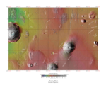
|
| MC-10 | Lunae Palus | 0–30° N | 45–90° W | Features | 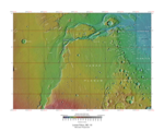
|
| MC-11 | Oxia Palus | 0–30° N | 0–45° W | Features | 
|
| MC-12 | Arabia | 0–30° N | 0–45° E | Features | 
|
| MC-13 | Syrtis Major | 0–30° N | 45–90° E | Features | 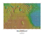
|
| MC-14 | Amenthes | 0–30° N | 90–135° E | Features | 
|
| MC-15 | Elysium | 0–30° N | 135–180° E | Features | 
|
| MC-16 | Memnonia | 0–30° S | 135–180° W | Features | 
|
| MC-17 | Phoenicis Lacus | 0–30° S | 90–135° W | Features | 
|
| MC-18 | Coprates | 0–30° S | 45–90° W | Features | 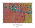
|
| MC-19 | Margaritifer Sinus | 0–30° S | 0–45° W | Features | 
|
| MC-20 | Sinus Sabaeus | 0–30° S | 0–45° E | Features | 
|
| MC-21 | Iapygia | 0–30° S | 45–90° E | Features | 
|
| MC-22 | Mare Tyrrhenum | 0–30° S | 90–135° E | Features | 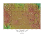
|
| MC-23 | Aeolis | 0–30° S | 135–180° E | Features | 
|
| MC-24 | Phaethontis | 30–65° S | 120–180° W | Features | 
|
| MC-25 | Thaumasia | 30–65° S | 60–120° W | Features | 
|
| MC-26 | Argyre | 30–65° S | 0–60° W | Features | 
|
| MC-27 | Noachis | 30–65° S | 0–60° E | Features | 
|
| MC-28 | Hellas | 30–65° S | 60–120° E | Features | 
|
| MC-29 | Eridania | 30–65° S | 120–180° E | Features | 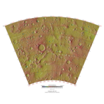
|
| MC-30 | Mare Australe | 65–90° S | 180° W – 180° E | Features | 
|
See also edit
References edit
- ^ a b c "PIA03467: The MGS MOC Wide Angle Map of Mars". Photojournal. NASA / Jet Propulsion Laboratory. 16 February 2002. Retrieved 14 May 2019.
- ^ a b Morton, Oliver (2002). Mapping Mars: Science, Imagination, and the Birth of a World. New York: Picador USA. p. 98. ISBN 0-312-24551-3.
- ^ "Online Atlas of Mars". Ralphaeschliman.com. Retrieved December 16, 2012.
- ^
- Schaber, Gerald G. (2005). "USGS Open-File Report 2005-1190: The U.S. Geological Survey, Branch of Astrogeology—A Chronology of Activities from Conception through the End of Project Apollo (1960–1973)" (PDF). United States Geological Survey. p. 314. Retrieved 14 May 2019.
- Schaber, Gerald G. (2005). "USGS Open-File Report 2005-1190: APPENDIX A (Selected Interviews with Branch of Astrogeology personnel)" (PDF). United States Geological Survey. p. 49. Retrieved 14 May 2019.