
KNOWPIA
WELCOME TO KNOWPIA

List of settlements in Illyria 
Summary
This list is incomplete; you can help by adding missing items. (December 2020) |
This is a list of settlements in Illyria founded by Illyrians (southern Illyrians, Dardanians, Pannonians), Liburni, Ancient Greeks and the Roman Empire. A number of cities in Illyria and later Illyricum were built on the sites or close to the sites of pre-existing Illyrian settlements, though that was not always the case. Some settlements may have a double entry, for example the Ancient Greek Pola, Roman Pietas Julia, and some toponyms are reconstructed.
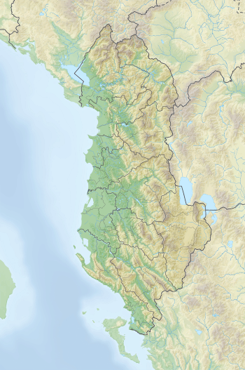
Albania edit
Identified sites edit
| # | Settlement[note 1] | Habitation | Location | Geographic coordinates | Ref. |
|---|---|---|---|---|---|
| 1 | Ad Acroceraunia | Near Llogara Pass | 40°16′52″N 19°27′20″E / 40.28111°N 19.45556°E | [1] | |
| 2 | Ad Quintum | Bradashesh | 41°05′38″N 20°00′54″E / 41.09389°N 20.01500°E | [2] | |
| 3 | Akrolissos, Lissus | Lezhë | 41°46′58″N 19°38′38″E / 41.78278°N 19.64389°E | [3] | |
| 4 | Amantia | Ploç | 40°22′37″N 19°42′0″E / 40.37694°N 19.70000°E | [1] | |
| 5 | Antipatrea | Berat | 40°42′0″N 19°57′0″E / 40.70000°N 19.95000°E | [4] | |
| 6 | Apollonia | Pojan | 40°44′2″N 19°27′46″E / 40.73389°N 19.46278°E | [1] | |
| 7 | Aulon | Vlorë | 40°28′0″N 19°29′0″E / 40.46667°N 19.48333°E | [5] | |
| 8 | Bushat | Bushat | 41°58′1″N 19°31′59″E / 41.96694°N 19.53306°E | [6] | |
| 9 | Byllis | Hekal | 40°32′25″N 19°44′15″E / 40.54028°N 19.73750°E | [7] | |
| 10 | Cerje | Cerje, Vlorë | 40°16′11″N 19°41′13″E / 40.26972°N 19.68694°E | [8] | |
| 11 | Dimale | Krotinë | 40°42′59″N 19°47′49″E / 40.71639°N 19.79694°E | [9] | |
| 12 | Dukat | Dukat | 40°15′11″N 19°34′02″E / 40.25306°N 19.56722°E | [10] | |
| 13 | Epidamnos | Durrës | 41°18′40″N 19°26′21″E / 41.31111°N 19.43917°E | [11] | |
| 14 | Gajtan | Gajtan | 42°3′23″N 19°34′20″E / 42.05639°N 19.57222°E | [12] | |
| 15 | Grunas | Grunas | 42°25′10″N 19°46′50″E / 42.41944°N 19.78056°E | [13] | |
| 16 | Kaninë | Kaninë | 40°26′23″N 19°31′8″E / 40.43972°N 19.51889°E | [14] | |
| 17 | Kratul | Kratul | 42°7′22″N 19°34′30″E / 42.12278°N 19.57500°E | [12] | |
| 18 | Kukës | Kukës | 42°4′51″N 20°25′12″E / 42.08083°N 20.42000°E | ||
| 19 | Lofkënd | Lofkënd | 40°38′28″N 19°44′45″E / 40.64111°N 19.74583°E | [15] | |
| 20 | Hija e Korbit | Maliq | 40°42′30″N 20°42′0″E / 40.70833°N 20.70000°E | [16] | |
| 21 | Margëlliç | Margëlliç | 40°40′19″N 19°39′40″E / 40.67194°N 19.66111°E | [14] | |
| 22 | Mat | Mat | 41°37′1″N 20°0′0″E / 41.61694°N 20.00000°E | ||
| 23 | Matohasanaj | Matohasanaj | 40°21′14″N 19°49′59″E / 40.35389°N 19.83306°E | [17] | |
| 24 | Nikaia | Klos | 40°31′44″N 19°45′7″E / 40.52889°N 19.75194°E | [18] | |
| 25 | Nymphaion (sanctuary) | Selenicë | 40°31′59″N 19°37′59″E / 40.53306°N 19.63306°E | [19] | |
| 26 | Nymphaion (harbour) | Shëngjin | 41°48′50″N 19°35′39″E / 41.81389°N 19.59417°E | [18] | |
| 27 | Olympe | Mavrovë | 40°24′32″N 19°35′28″E / 40.40889°N 19.59111°E | [20] | |
| 28 | Orikon | Orikum | 40°19′23″N 19°27′7″E / 40.32306°N 19.45194°E | [21] | |
| 29 | Persqopi | Tirana | 41°19′44″N 19°49′4″E / 41.32889°N 19.81778°E | ||
| 30 | Pogradec | Pogradec | 40°54′0″N 20°39′0″E / 40.90000°N 20.65000°E | [22] | |
| 31 | Rabije | Rabije | 40°28′55″N 19°56′21″E / 40.48194°N 19.93917°E | [23] | |
| 32 | Redon | Cape of Rodon | 41°35′2″N 19°27′0″E / 41.58389°N 19.45000°E | ||
| 33 | Scampa | Elbasan | 41°6′40″N 20°4′51″E / 41.11111°N 20.08083°E | ||
| 34 | Selcë e Poshtme | Selcë e Poshtme | 40°58′59″N 20°31′1″E / 40.98306°N 20.51694°E | [24] | |
| 35 | Scodra | Shkodër | 42°4′1″N 19°30′0″E / 42.06694°N 19.50000°E | [25] | |
| 36 | Tren | Tren | 40°39′58″N 21°0′0″E / 40.66611°N 21.00000°E | [26] | |
| 37 | Triport | Triport, Vlorë | 40°30′05″N 19°24′43″E / 40.50139°N 19.41194°E | [27] | |
| 38 | Zgërdhesh | Zgërdhesh | 41°28′23″N 19°48′54″E / 41.47306°N 19.81500°E | [6] |
Unidentified sites edit
| Settlement | Description | Proposed location | Ref. |
|---|---|---|---|
| Albanopolis | Zgërdhesh | [28] | |
| Bargulum | Berat | [29] | |
| Bassania | Pedhanë or Bushat | [30] | |
| Boioi | On the shore of Ohrid | [31] | |
| Chrysondyon | — | [32] | |
| Creonion | — | [32] | |
| Damastion | — | [33] | |
| Enchelanae | On the shore of Ohrid, Pogradec Castle | [34] | |
| Gertous | — | [32] | |
| Kerax | On the shore of Ohrid | [34] | |
| Kodrion | Kalaja e Irmajt near Gramsh | [35] | |
| Parthus | Berat | [36] | |
| Pelion | Near Ohrid and Prespa | [37] | |
| Sation | On the shore of Ohrid | [31] | |
| Sesarethus | Near Ohrid and Prespa | [38] | |
| Thronion | Triport, Vlorë; Kaninë | [39] | |
| Uscana | — |
Bosnia and Herzegovina edit
Identified sites edit

| # | Settlement[note 2] | Description | Location | Geographic coordinates | Ref. |
|---|---|---|---|---|---|
| 1 | Arduba | Vranduk | 44°17′34″N 17°54′14″E / 44.29278°N 17.90389°E | [40] | |
| 2 | Daorson | Near Stolac | 43°4′59″N 17°58′0″E / 43.08306°N 17.96667°E | [41] | |
| 3 | Delminium | Tomislavgrad | 43°43′0″N 17°14′0″E / 43.71667°N 17.23333°E | [42] | |
| 4 | Hedum Kastelum | Breza | 44°1′11″N 18°15′53″E / 44.01972°N 18.26472°E | ||
| 5 | Ošanjići | Ošanjići, Stolac | 43°5′24″N 17°56′24″E / 43.09000°N 17.94000°E | [43] |
Unidentified sites edit
| Settlement | Description | Proposed location | Ref. |
|---|---|---|---|
| Salvia | Near Bosansko Grahovo | [44] |
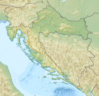
Croatia edit
Identified sites edit
| # | Settlement | Description | Location | Geographic coordinates | Ref. |
|---|---|---|---|---|---|
| 1 | Aenona | Nin | 44°14′0″N 15°11′0″E / 44.23333°N 15.18333°E | [45] | |
| 2 | Aequum | Near Čitluk | 43°45′0″N 16°38′0″E / 43.75000°N 16.63333°E | [46] | |
| 3 | Alvona | Labin | 45°5′0″N 14°7′0″E / 45.08333°N 14.11667°E | [47] | |
| 4 | Andetrium | Muć | 43°41′26″N 16°29′2″E / 43.69056°N 16.48389°E | [48] | |
| 5 | Apsorus | Osor | 44°42′0″N 14°24′0″E / 44.70000°N 14.40000°E | ||
| 6 | Arba | Rab | 44°45′22″N 14°45′40″E / 44.75611°N 14.76111°E | ||
| 7 | Argyruntum | Starigrad | 44°17′43″N 15°26′17″E / 44.29528°N 15.43806°E | ||
| 8 | Aspálathos | Split | 43°30′36″N 16°27′0″E / 43.51000°N 16.45000°E | [49] | |
| 9 | Asseria | Near Podgrađe | 44°0′36″N 15°40′4″E / 44.01000°N 15.66778°E | ||
| 10 | Burnum | Near Kistanje | 44°1′5″N 16°1′33″E / 44.01806°N 16.02583°E | [50] | |
| 11 | Colentum | Near Betina | 43°49′22″N 15°36′17″E / 43.82278°N 15.60472°E | ||
| 12 | Corinium | Near Benkovac | 44°06′16″N 15°38′01″E / 44.10444°N 15.63361°E | [51] | |
| 13 | Crepsa | Cres | 44°57′36″N 14°24′29″E / 44.96000°N 14.40806°E | ||
| 14 | Curicum | Krk | 45°1′0″N 14°34′0″E / 45.01667°N 14.56667°E | ||
| 15 | Epetium | Stobreč | 43°29′58″N 16°31′20″E / 43.49944°N 16.52222°E | [52] | |
| 16 | Epidaurum | Cavtat | 42°34′46″N 18°13′15″E / 42.57944°N 18.22083°E | [53] | |
| 17 | Flanona | Plomin | 45°8′16″N 14°10′51″E / 45.13778°N 14.18083°E | [54] | |
| 18 | Fulfinum | Near Omišalj | 45°12′42″N 14°33′15″E / 45.21167°N 14.55417°E | [55] | |
| 19 | Iader or Idassa | Zadar | 44°7′10″N 15°13′55″E / 44.11944°N 15.23194°E | ||
| 20 | Issa | Vis | 43°4′0″N 16°11′0″E / 43.06667°N 16.18333°E | [56] | |
| 21 | Lopsica | Sveti Juraj | 44°55′32″N 14°55′8″E / 44.92556°N 14.91889°E | ||
| 22 | Lumbarda | Lumbarda | 42°55′19″N 17°10′12″E / 42.92194°N 17.17000°E | [57] | |
| 23 | Melaina Korkyra | Korčula | 42°57′0″N 17°7′0″E / 42.95000°N 17.11667°E | [56] | |
| 24 | Mursa | Osijek | 45°33′20″N 18°41′40″E / 45.55556°N 18.69444°E | ||
| 25 | Narona | Momići | 43°2′47″N 17°35′55″E / 43.04639°N 17.59861°E | [58][59] | |
| 26 | Nedinum | Nadin | 44°4′27″N 15°29′53″E / 44.07417°N 15.49806°E | ||
| 27 | Nesactium | Nesactium | 44°55′0″N 13°58′11″E / 44.91667°N 13.96972°E | [60] | |
| 28 | Pharos | Hvar | 43°8′0″N 16°44′0″E / 43.13333°N 16.73333°E | [61] | |
| 29 | Pola | Pula | 44°52′0″N 13°51′0″E / 44.86667°N 13.85000°E | [56] | |
| 30 | Portunata | Novalja | 44°33′0″N 14°53′0″E / 44.55000°N 14.88333°E | ||
| 31 | Promona | Tepljuh | 43°54′0″N 16°12′0″E / 43.90000°N 16.20000°E | [62] | |
| 32 | Salona | Solin | 43°32′22″N 16°28′59″E / 43.53944°N 16.48306°E | [63][64] | |
| 33 | Senia | Senj | 44°59′25″N 14°54′11″E / 44.99028°N 14.90306°E | ||
| 34 | Tilurium | Near Trilj | 43°36′41″N 16°42′57″E / 43.61139°N 16.71583°E | [44] | |
| 35 | Tragurion or Tragorium | Trogir | 43°31′1″N 16°15′5″E / 43.51694°N 16.25139°E | [65] | |
| 36 | Varvaria | Bribir | 43°44′0″N 15°51′0″E / 43.73333°N 15.85000°E |
Unidentified sites edit
| Settlement | Description | Proposed location | Ref. |
|---|---|---|---|
| Nareste | Near Omiš | [66] | |
| Oneum | Omiš | [66] | |
| Pituntium | Podstrana | [66] | |
| Saloniana | Imotski | ||
| Setovia | Sinj | [44] | |
| Tariona | — | [67] |
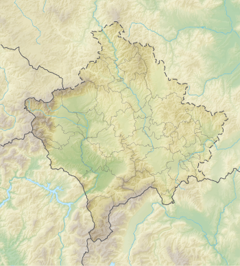
Kosovo edit
Identified sites edit
| # | Settlement[note 3] | Description | Location | Geographic coordinates | Ref. |
|---|---|---|---|---|---|
| 1 | Municipium Dardanorum | Soqanicë | 43°3′17″N 20°48′36″E / 43.05472°N 20.81000°E | [68] | |
| 2 | Romajë | Romajë | 42°17′31″N 20°35′34″E / 42.29194°N 20.59278°E | [69] | |
| 3 | Busavatë | Busavatë | 42°34′49″N 21°32′36″E / 42.58028°N 21.54333°E | [70] | |
| 4 | Ulpiana | Ulpiana | 42°35′47″N 21°10′31″E / 42.59639°N 21.17528°E | [71] | |
| 5 | Vindenis | Gllamnik | 42°51′58″N 21°10′59″E / 42.86611°N 21.18306°E | [72] | |
| 6 | Vlashnjë | Vlashnjë | 42°12′09″N 20°39′45″E / 42.20250°N 20.66250°E | ||
| 7 | Topanicë | Topanicë | 42°31′25″N 21°38′23″E / 42.52361°N 21.63972°E | [73] | |
| 8 | Dubovc | Dubovc | 42°46′37″N 20°54′37″E / 42.77694°N 20.91028°E | [74] | |
| 9 | Dardana Fortress | Kamenica | 42°35′33″N 21°33′49″E / 42.59250°N 21.56361°E | [75] |
Unidentified sites edit
| Settlement | Description | Proposed location | Ref. |
|---|---|---|---|
| Theranda | Suhareka or Prizren |
Montenegro edit
Identified sites edit

| # | Settlement[note 4] | Description | Location | Geographic coordinates | Ref. |
|---|---|---|---|---|---|
| 1 | Acruvium | Kotor | 42°25′48″N 18°46′12″E / 42.43000°N 18.77000°E | [76] | |
| 2 | Anderba, Enderon | Nikšić | 42°46′40″N 18°57′00″E / 42.77778°N 18.95000°E | [77] | |
| 3 | Buthoe | Budva | 42°17′16″N 18°50′35″E / 42.28778°N 18.84306°E | [6] | |
| 4 | Doclea | Podgorica | 42°28′5″N 19°15′54″E / 42.46806°N 19.26500°E | [6] | |
| 5 | Gostilj | Gostilj | 42°29′13″N 18°41′56″E / 42.48694°N 18.69889°E | ||
| 6 | Meteon | Medun | 42°28′23″N 19°21′43″E / 42.47306°N 19.36194°E | [6] | |
| 7 | Oblun | Oblun | 42°22′59″N 19°08′13″E / 42.38306°N 19.13694°E | [6] | |
| 8 | Perast | Perast | 42°29′13″N 18°41′56″E / 42.48694°N 18.69889°E | ||
| 9 | Rhizon | Risan | 42°30′54″N 18°41′21″E / 42.51500°N 18.68917°E | [6] | |
| 10 | Samobor | Samobor | 42°18′44″N 19°21′53″E / 42.31222°N 19.36472°E | [6] | |
| 11 | Stara Gradina | Stara Gradina | 42°49′41″N 19°17′13″E / 42.82806°N 19.28694°E | [6] | |
| 12 | Ulkinion | Ulcinj | 41°55′12″N 19°12′0″E / 41.92000°N 19.20000°E | [6] |
Unidentified sites edit
| Settlement | Description | Proposed location | Ref. |
|---|---|---|---|
| Kinna | Along the Cem River | [77] |
North Macedonia edit
Identified sites edit

| # | Settlement[note 5] | Description | Location | Geographic coordinates | Ref. |
|---|---|---|---|---|---|
| 1 | Lychnidos | Ohrid | 41°7′0″N 20°48′0″E / 41.11667°N 20.80000°E | ||
| 2 | Oaeneon, Oaeneum | Tetovo | 42°0′0″N 20°58′0″E / 42.00000°N 20.96667°E | ||
| 3 | Scupi | Skopje | 42°0′59″N 21°23′31″E / 42.01639°N 21.39194°E | [78] |
Unidentified sites edit
| Settlement | Description | Proposed location | Ref. |
|---|---|---|---|
| Damastion | — |
Serbia edit
Identified sites edit
| # | Settlement[note 6] | Description | Location | Geographic coordinates | Ref. |
|---|---|---|---|---|---|
| 1 | Navissos, Naissus | Niš | 43°19′16″N 21°53′44″E / 43.32111°N 21.89556°E | [79][80] |
Unidentified sites edit
| Settlement | Description | Proposed location | Ref. |
|---|---|---|---|
| Damastion | — |
Illyrian settlements edit
Liburnian cities edit
Venetic cities edit
Roman cities edit
- Gabuleus[citation needed]
- Crevenia[citation needed]
- Corragum[85] fortress[86]
- Clodiana[87]
- Marusium[87]
A very small part of the Roman province of Italia included Istria.
- Aruccia[88]
- Arauzona[citation needed]
- Arba, Scardona[89][90]
- Aleta, Dalmatia[citation needed]
- Berginium[citation needed]
- Ausancali[citation needed]
- Jader[76]
- Herona[citation needed]
- Senia, Liburnia[76]
- Adra, Liburnia[citation needed]
- Sicum[91]
- Blanona, Liburnia[citation needed]
- Siparuntum[92]
- Ouporum[citation needed]
- Iminacium[citation needed]
- Stulpi[citation needed]
- Ardotium[citation needed] mentioned by Pliny and Ptolemy to be at inland Liburnia
- Collentum[citation needed]
- Tediastum[88] inland Liburnia, along river Tedanius
- Curcum[88]
- Vicianum[citation needed]
- Velanis[citation needed]
Mislocated edit
See also edit
Notes edit
References edit
- ^ a b c Wilkes 2000, p. 750.
- ^ de Matteis 2017, p. 12
- ^ Wilkes 2000, pp. 750, 753; Shpuza 2014, p. 106.
- ^ Cabanes 2008, p. 35; Mesihović & Šačić 2015, p. 47; Zindel et al. 2018, pp. 278, 280.
- ^ Wilkes 2000, p. 751; Papadopoulos 2016, p. 437.
- ^ a b c d e f g h i j Shpuza 2017, p. 42; Shpuza & Dyczek 2019, p. 101; Lemke, Shpuza & Wojciechowski 2021, p. 1.
- ^ Wilkes 2000, p. 751.
- ^ Ceka & Ceka 2017, p. 491; Çipa 2020, p. 216.
- ^ Wilkes 2000, p. 752; Muka & Heinzelmann 2014, p. 223.
- ^ Shpuza 2022, p. 553; Bodinaku 2001, pp. 97–100.
- ^ Wilkes 2000, p. 752.
- ^ a b Shpuza 2014, p. 106.
- ^ Tafilica, Baze & Lafe 2023, p. 70.
- ^ a b Ceka & Ceka 2017, p. 492; Çipa 2020, p. 216.
- ^ Bejko et al. 2015, p. 4; Zindel et al. 2018, pp. 375–376.
- ^ Zindel et al. 2018, pp. 375–376.
- ^ Ceka & Ceka 2017, p. 490.
- ^ a b Wilkes 2000, p. 754.
- ^ Wilkes 2000, p. 754; Bejko et al. 2015, p. 4; Papadopoulos 2016, p. 440; Larson 2001, p. 162.
- ^ Zindel et al. 2018, p. 332
- ^ Shpuza 2022, p. 553; Wilkes 2000, p. 754; Papadopoulos 2016, p. 437.
- ^ Doka & Qiriazi 2022, p. 241.
- ^ Ceka 2012, pp. 59–60.
- ^ Wilkes 2000, p. 755; Zindel et al. 2018, p. 401.
- ^ Wilkes 2000, p. 755; Shpuza 2017, p. 42.
- ^ Wilkes 1992, p. 18.
- ^ Volpe et al. 2014, p. 300; Bereti 1993, p. 143.
- ^ Wilkes 2000, p. 750; Shpuza 2017, p. 42.
- ^ Ceka 2009, p. 17
- ^ Šašel Kos 2005, p. 286; Nauka W Polsce 2018.
- ^ a b Jaupaj 2019, p. 75.
- ^ a b c Cabanes 2008, p. 35; Mesihović & Šačić 2015, p. 47.
- ^ Wilkes 1992, p. 223; Wilkes & Fischer-Hansen 2004.
- ^ a b Jaupaj 2019, pp. 74–75; Doka & Qiriazi 2022, p. 241.
- ^ Morton 2017, p. 37
- ^ Ceka 2009, p. 7; Šašel Kos 2005, p. 282.
- ^ Winnifrith 2002, p. 282; Cabanes 2008, p. 35; Mesihović & Šačić 2015, p. 47.
- ^ Ujes 2002, p. 106.
- ^ Volpe et al. 2014, p. 300; Cabanes 2008, p. 171; Bereti 1993, p. 143; Wilkes 2000, p. 758; Papadopoulos 2016, p. 439.
- ^ Stipčević, Aleksandar, The Illyrians-History and Culture, 1974, Noyess Press
- ^ Dalmatia: research in the Roman province 1970-2001: papers in honour of J. J. Wilkes by David Davison, Vincent L. Gaffney, Emilio Marin, 2006, page 21, "completely Hellenised town."
- ^ Wilkes 1992, p. 188
- ^ Boško 2011, p. 177.
- ^ a b c Wilkes 1992, p. 190.
- ^ S. Čače, Broj liburnskih općina i vjerodostojnost Plinija(Nat. hist. 3, 130; 139–141), Radovi Filozofskog fakulteta u Zadru, 32, Zadar 1993., pages 1–36
- ^ The Princeton Encyclopedia of Classical Sites (eds. Richard Stillwell, William L. MacDonald, Marian Holland McAllister), " AEQUUM (Čitluk) Croatia, Yugoslavia. The Roman Colonia Claudia Aequum was situated 6 km N of Sinj. It was founded by the emperor Claudius sometime after AD 45 and settled with the veterans of Legio VII when they left the neighboring camp at Tilurium for Moesia."
- ^ Dalmatia by J. J. Wilkes, 1969, page 194, "By the early years of Augustus the inhabitants of Alvona the Alutrenses..."
- ^ Šašel Kos & Kos 2020: "Andetrium".
- ^ Wilkes 1992, p. 100.
- ^ The Princeton Encyclopedia of Classical Sites (eds. Richard Stillwell, William L. MacDonald, Marian Holland McAllister), "BURNUM (Ivoševci by Kistanje) Croatia, Yugoslavia.The military camp of Legio XI Claudia Pia Fidelis situated over the gorge of the Krka (Titius) river just opposite the Dalmatian hill fort on the E river bank..."
- ^ Šašel Kos & Kos 2017, Places: 197225 (Corinium); Bagendon: a Belgic oppidum: a record of the excavations of 1954–56 – page 1 by Elsie M. Clifford – 1961 – "Chapter I the Bagendon Site the Identification of Corinium ... and was therefore called by the Roman Corinium"
- ^ Boršić, Džino & Radić Rossi 2021, pp. 19, 21
- ^ Wilkes 1992, p. 216
- ^ Dalmatia by J. J. Wilkes, 1969, page 195, "At Flavona the native population was well established and stood up better to the effects of italian settlement in the first century..."
- ^ Šašel Kos & Kos 2019, Places: 197280 (Fulfinium/Fertinium); The archaeology of Roman towns: studies in honour of John S. Wacher, ISBN 1-84217-103-8, page 235, by J. S. Wacher, Peter R. Wilson, 2003, "The reward was the status of Roman colony and an infusion of new settlers, granted either by Caesar himself [...] at Fulfinium and in the south on the"
- ^ a b c Wilkes & Fischer-Hansen 2004.
- ^ Boršić, Džino & Radić Rossi 2021, pp. 19, 20
- ^ OxfordJournal, "There had been an emporion or trading post on the site from the 2nd century BC, Pola, now Pietas Julia..."
- ^ The Roman army, 31 BC-AD 337: a sourcebook – page 215 by J. B. Campbell, ISBN 0-415-07173-9, 1994, "The civilian colony of Narona had been founded at the end of Caesar's dictatorship..."
- ^ Wilkes 1992, p. 183.
- ^ Wilkes 1992, p. 114.
- ^ Wilkes 1992, p. 197.
- ^ Excavations at Salona, Yugoslavia, 1969–1972: conducted for the Department of Classics, Douglass College, Rutg, by Christoph W. Clairmont, 1975, ISBN 0-8155-5040-5, page 4, "If we are correct in our interpretation of the earliest finds from Salona, the emporion, even if very small, was a settlement in a strategic position..."
- ^ The Cambridge ancient history, Volume 10 by Alan K. Bowman, Edward Champlin, Andrew Lintott, page 845, "The colony of Salona on the Dalmatian coast used almost identical formulae in dedicating an altar of Jupiter Optimus Maximus..."
- ^ Croatia, 2nd: The Bradt Travel Guide Croatiaby Piers Letcher, 2005, ISBN 1-84162-113-7, page 225, "... History Trogir started out in the 3rd century BC; as Tragurion, an offshoot of the Greek colony of Issa (on Vis), ..."
- ^ a b c Dalmatia by J. J. Wilkes, 1969, page 227, "In this area were three small communities of the Delmatae Pituntium(Podstrana) Nareste(Jenesice) and Oneum (Omis)..."
- ^ Miletić 2008, p. 61; Catani 2008, p. 77.
- ^ Wilkes 1992, p. 258.
- ^ Schermer, Shukriu & Deskaj 2011, p. 236.
- ^ Alaj 2019, p. 41.
- ^ The Roman army as a community: including papers of a conference held at ...by Adrian Keith Goldsworthy, Ian Haynes, Colin E. P. Adams, ISBN 1-887829-34-2, 1997, page 100
- ^ Fjalor enciklopedik shqiptar, Akademia e Shkencave e Shqipërisë, Tiranë, 2009, fq. 2870 – 2871. ISBN 978-99956-10-32-6.
- ^ Alaj 2019, p. 51.
- ^ Alaj 2019, p. 65.
- ^ Alaj 2019, p. 91.
- ^ a b c Wilkes 1992, p. 213.
- ^ a b Wilkes 1996, p. 577.
- ^ The Roman army as a community: including papers of a conference held at ...by Adrian Keith Goldsworthy, Ian Haynes, Colin E. P. Adams, ISBN 1-887829-34-2, 1997, page 39, "...the colony at Scupi which lost its original title Domitiana after Domitians death..."
- ^ "Nis, Britanica". Archived from the original on 2008-10-13. Retrieved 2009-08-25.
- ^ The central Balkan tribes in pre-Roman times: Triballi, Autariatae ... by Fanula Papazoglu, 1978, page 198, "... the Peutinger Table marks 40 miles from Naissus, on the Naissus-founded by Auielian..."
- ^ The classical gazetteer: a dictionary of ancient geography, sacred and profane by William Hazlitt, 1851, "Epicaria a town of the Cavii in Illyria."
- ^ The Cambridge Ancient History, Volume 8: Rome and the Mediterranean to 133 BC by A. E. Astin, ISBN 0-521-23448-4, 1990, page 92
- ^ Dalmatia by J. J. Wilkes, 1969, page 216, "Little is known about Sidrona the city of the Sidrini."
- ^ a b c d Pliny's Natural History, Book 3, (C. Plinii Secundi Naturalis Historiæ, Liber III), Chap. 23. (19.) – Istria, Its People and Locality."In this district there have disappeared—upon the coast—Iramene, Pellaon, and Palsatium, Atina and Cælina belonging to the Veneti "
- ^ Talbert, Richard J. A. (8 October 2000). Barrington atlas. Princeton University Press. ISBN 0691049459. Archived from the original on 2016-10-12. Retrieved 2016-10-04.
- ^ "Titi Livi". Archived from the original on 2011-06-29. Retrieved 2010-02-23.
- ^ a b "MARU´SIUM". Archived from the original on 2011-06-29. Retrieved 2010-02-23.
- ^ a b c Ptolemy
- ^ Dalmatia: research in the Roman province 1970–2001: papers in honour of J.J, page 108, by David Davison, Vincent L. Gaffney, J. J. Wilkes, Emilio Marin, ISBN 1-84171-790-8, 2006, "For instance, the town walls of Arba were constructed under Augustus..."
- ^ The archaeology of Roman towns: studies in honour of John S. Wacher, page 237, by J. S. Wacher, Peter R. Wilson, ISBN 1-84217-103-8, 2003, "Roman island towns in Liburnia were Arba..."
- ^ Roman life and manners under the early Empire – page 302 – by Ludwig Friedlaender – 1965, "Claudius settled veterans at Cumae, Cologne, Sicum in Dalmatia, Camulodunum in Britain, ..."
- ^ The central Balkan tribes in pre-Roman times: Triballi, Autariatae ... by Fanula Papazoglu, 1978, page 250, "Town in the interior of Dalmatia, located between Scodra and Siparuntum."
- ^ Lepper 1988, p. 138:Stuart Jones noted the Dacian - sounding place - name ' Thermidava ' on the Lissus Naissus road : but see Miller col . 557, for the evidence on this. The place was most probably called ' Theranda ' and there is no evidence for any settlement there of pro-Roman Dacians now, nor is it very likely. (..) Most scholars, however, have supposed, as did Cichorius, that we are now north of the Danube, somewhere in the Banat area where the local inhabitants are frightened that they may lose their recently acquired 'liberty'.
Bibliography edit
- Alaj, Premtim (2019). Les habitats de l'Age du fer sur le territoire de l'actuel Kosovo (Thesis). Université de Lyon.
- Bejko, Lorenc; Morris, Sarah; Papadopoulos, John; Schepartz, Lynne (2015). The Excavation of the Prehistoric Burial Tumulus at Lofkend, Albania. ISD LLC. ISBN 978-1938770524.
- Bereti, Vasil (1993). "Gjurmë të fortifikimeve në vendbanimin në Treport / Traces de fortifications dans l'habitat à Treport". Iliria. 23: 143–159. doi:10.3406/iliri.1993.1622.
- Bodinaku, Namik (2001). "Varreza tumulare e Dukatit në rrethin e Vlorës (Gërmime 1973-74)" [The Tumulus Necropolis of Dukat in Vlora city (Excavations between 1973-74]. Iliria. 30: 9–100. doi:10.3406/iliri.2001.1724.
- Boršić, Luka; Džino, Danijel; Radić Rossi, Irena (2021). Liburnians and Illyrian Lembs: Iron Age Ships of the Eastern Adriatic. Archaeopress Publishing Ltd. ISBN 9781789699166.
- Boško, Marijan (2011). "Gradina u Ošanićima – transformacija prapovijesnoga gradinskog u urbano naselje". Histria Antiqua. 20 (20).
- Cabanes, Pierre (2008). "Greek Colonisation in the Adriatic". In Tsetskhladze, Gocha R. (ed.). Greek Colonisation: An Account of Greek Colonies and Other Settlements Overseas. Vol. 2. Brill. pp. 155–186. ISBN 9789047442448.
- Catani, Lorenzo (2008). "Arheološko-povijesne bilješke o Castellum Tariona u rimsko doba" [Archaeological and historical notes on the Castellum Tariona in the Roman Era]. Vjesnik Za Arheologiju I Povijest Dalmatinsku (in Croatian and English). 101 (1). Split: 75–86.
- Ceka, Neritan (2009). "Atintanët: një rivështrim mbi territorin dhe historinë e tyre / Les Atintanes, un nouvel aperçu de leur territoire et de leur histoire". Iliria. 34: 5–23. doi:10.3406/iliri.2009.1078.
- Ceka, Neritan (2011). "Cezari në Akrokeraune- vende dhe gjurmë / Cesare in acroceraunia-luoghi e tracce". Iliria. 35: 99–122. doi:10.3406/iliri.2011.1101.
- Ceka, Neritan; Ceka, Olgita (2017). "A Peripolarchos inscription from the castle of Matohasanaj". In Luan Përzhita; Ilir Gjipali; Gëzim Hoxha; Belisa Muka (eds.). New archaeological discoveries in the Albanian regions: proceedings of the international conference 30 - 31 January, Tirana 2017. Vol. 1. Botimet Albanologjike. Academy for Albanian Studies, Institute of Archaeology. pp. 488–508. ISBN 978-9928-141-71-2.
- Ceka, Olgita (2012). "Il koinon e la città. L'esempio di Byllis". In G. de Marinis; G.M. FabriniG. Paci; R. Perna; M. Silvestrini (eds.). I processi formativi ed evolutividella città in area adriatica. BAR International Series. Vol. 2419. Archaeopress. pp. 59–64. ISBN 978-1-4073-1018-3.
- Çipa, Kriledjan (2020). "The fortified settlement of Borshi and its role in Chaonia fortification system". In Luigi Maria Caliò; Gian Michele Gerogiannis; Maria Kopsacheili (eds.). Fortificazioni e società nel Mediterraneo occidentale: Albania e Grecia settentrionale [Fortifications and Societies in the Western Mediterranean: Albania and Northern Greece]. Quasar. ISBN 9788854910430.
- de Matteis, Mario (2017). "Stazioni di sosta (mutationes) lungo la via Egnazia". Palaver. 6 (2): 7–28. doi:10.1285/i22804250v6i2p7. ISSN 2280-4250.
- Doka, Dhimitёr; Qiriazi, Perikli (2022). The Geography of Albania: Problems and Perspectives. World Regional Geography Book Series. Springer Nature. ISBN 9783030855512.
- Fasolo, Michele (2009). "La via Egnatia nel territorio della Repubblica di Macedonia". In Cesare Marangio; Giovanni Laudizi (eds.). Παλαιά Φιλία [Palaià Philía]: studi di topografia antica in onore di Giovanni Uggeri. Journal of Ancient Topography - Rivista di Topografia Antica (in Italian). Vol. 4. Mario Congedo editore. pp. 601–612. ISBN 9788880868651.
- Jaupaj, Lavdosh (2019). Etudes des interactions culturelles en aire Illyro-épirote du VII au III siècle av. J.-C (Thesis). Université de Lyon; Instituti i Arkeologjisë (Albanie).
- Larson, Jennifer Lynn (2001). Greek Nymphs: Myth, Cult, Lore. New York: Oxford University Press. ISBN 978-0-19-514465-9.
- Lemke, Martin; Shpuza, Saimir; Wojciechowski, Bartosz (2021). "Bushat, not lost but found: a ' new ' Illyrian settlement in northern Albania". Antiquity. 95 (380): 1–9. doi:10.15184/aqy.2021.11. S2CID 232432547.
- Lepper, F. A. (1988). Trajan's Column: A New Edition of the Cichorius Plates. Alan Sutton. ISBN 9780862994679.
- Mesihović, Salmedin; Šačić, Amra (2015). Historija Ilira [History of Illyrians] (in Bosnian). Sarajevo: Univerzitet u Sarajevu [University of Sarajevo]. ISBN 978-9958-600-65-4.
- Miletić, Alen (2008). "Castellum Tariona" [The Castellum Tariona]. Vjesnik Za Arheologiju I Povijest Dalmatinsku (in Croatian and English). 101 (1). Split: 59–74.
- Miraj, Lida (2002). "The Earliest Coinage of Epidamnos/Dyrrachion as a Source". In Cambi, Nenad; Čače, Slobodan; Kirigin, Branko (eds.). Greek influence along the East Adriatic Coast. Knjiga Mediterana. Vol. 26. pp. 435–470. ISBN 9531631549.
- Morton, Jacob Nathan (2017). "Shifting Landscapes, Policies, And Morals: A Topographically Driven Analysis Of The Roman Wars In Greece From 200 Bc To 168 Bc". Publicly Accessible Penn Dissertations. 2484. University of Pennsylvania.
- Muka, Belisa; Heinzelmann, Michael (2014). "Dimal: new results of the Albanian-German research project". In Molla, Nevilla (ed.). Proceedings of the International Congress of Albanian Archaeological Studies: 65th Anniversary of Albanian Archaeology (21-22 November, Tirana 2013). Tiranë: Botimet Albanologjike. pp. 223–231. ISBN 9789928141286.
- Papadopoulos, John (2016). "Komai, Colonies and Cities in Epirus and Southern Albania: The Failure of the Polis and the Rise of Urbanism on the Fringes of the Greek World". In Molloy, Barry P.C. (ed.). Of Odysseys and Oddities: Scales and Modes of Interaction Between Prehistoric Aegean Societies and their Neighbours. Oxbow Books. pp. 435–460. ISBN 978-1-78570-232-7.
- Šašel Kos, Marjeta (2005). Appian and Illyricum. Narodni Muzej Slovenije. ISBN 978-961-6169-36-3.
- Šašel Kos, M.; Kos, P. (2017). "Places: 197225 (Corinium)". Pleiades. Retrieved 22 November 2020.
- Šašel Kos, M.; Kos, P. (2019). "Places: 197280 (Fulfinium/Fertinium)". Pleiades. Retrieved 22 November 2020.
- Šašel Kos, M.; Kos, P. (2020). "Places: 197115 (Andetrium)". Pleiades. Retrieved 2020-10-24.
- Schermer, Shirley; Shukriu, Edi; Deskaj, Sylvia (2011). Marquez-Grant, Nicholas; Fibiger, Linda (eds.). The Routledge Handbook of Archaeological Human Remains and Legislation: An International Guide to Laws and Practice in the Excavation and Treatment of Archaeological Human Remains. Taylor & Francis. ISBN 978-1136879562.
- Shpuza, Saimir (2014). Dyczek, Piotr (ed.). "Iron Age Fortifications and the Origin of the City in the Territory of Scodra". Novensia. 25. Warszawa: Ośrodek Badań nad Antykiem Europy Południowo-Wschodniej: 105–126. ISBN 978-83-934239-96. ISSN 0860-5777.
- Shpuza, Saimir (2017). Dyczek, Piotr (ed.). "Scodra and the Labeates. Cities, rural fortifications and territorial defense in the Hellenistic period". Novensia. 28. Warszawa: Ośrodek Badań nad Antykiem Europy Południowo-Wschodniej: 41–64. ISBN 978-83-946222-5-1. ISSN 0860-5777.
- Shpuza, Saimir; Dyczek, Piotr (2019). "Qyteti ilir në Bushat. Fortifikimi, kronologjia dhe probleme të identifikimit të tij" [The Illyrian city at Bushat. Fortifications, Chronology and Problems of identification]. Iliria. XLII.
- Shpuza, Saimir (2022). "D'un limên à une polis. Orikos aux périodes archaïque et classique". In Brancato, Rodolfo (ed.). Schemata: la città oltre la forma : per una nuova definizione dei paesaggi urbani e delle loro funzioni: urbanizzazione e società nel Mediterraneo pre-classico: età arcaica. Edizioni Quasar. ISBN 9788854912755.
- Tafilica, Zamir; Baze, Ermal; Lafe, Ols (2023). "Historical Background". In Galaty, Michael L.; Bejko, Lorenc (eds.). Archaeological Investigations in a Northern Albanian Province: Results of the Projekti Arkeologjik i Shkodrës (PASH): Volume One: Survey and Excavation Results. Memoirs Series. Vol. 64. University of Michigan Press. ISBN 9781951538736.
- Ujes, Dubravka (2002). "Recherche sur la localisation de Damastion et ses mines". Revue numismatique. 6th. 6 (158): 103–129. doi:10.3406/numi.2002.1438.
- Volpe, Giuliano; Disantarosa, Giacomo; Leone, Danilo; Turchiano, Maria (2014). "Porti, approdi e itinerari dell'Albania meridionale dall'Antichità al Medioevo. Il 'Progetto Liburna'". Ricerche Archeologiche in Albania. Aracne: 287–326. doi:10.4399/978885487245516 (inactive 31 January 2024). hdl:11586/257570. ISBN 978-88-548-7245-5.
{{cite journal}}: CS1 maint: DOI inactive as of January 2024 (link) - Wilkes, John (1992). The Illyrians. Wiley. ISBN 9780631146711.
- Wilkes, J. J. (2000). "Map 49 Illyricum. Compiled by J.J. Wilkes, 1995". In Talbert, Richard J. A. (ed.). Barrington Atlas of the Greek and Roman World: Map-by-map Directory. Vol. 1. Princeton University Press. pp. 749–760. ISBN 0691049459.
- Wilkes, J. J. (1996). "The Danubian and Balkan provinces". In Alan K. Bowman; Edward Champlin; Andrew Linto (eds.). The Cambridge Ancient History: The Augustan Empire, 43 B.C—A.D. 69. Vol. 10. Cambridge University Press. pp. 545–585. ISBN 0521264308.
- Wilkes, J. J.; Fischer-Hansen, Tobias (2004). "The Adriatic". In Mogens Herman Hansen; Thomas Heine Nielsen (eds.). An Inventory of Archaic and Classical Poleis. Oxford University Press. pp. 321–337. ISBN 0-19-814099-1.
- Wilkes, John J. J. (2012). "Places: 481942 (Palaeste)". Pleiades. Retrieved 21 November 2020.
- Winnifrith, Tom J. (2002). Badlands-borderlands: a history of Northern Epirus/Southern Albania. London: Duckworth. ISBN 0-7156-3201-9.
- Zindel, Christian; Lippert, Andreas; Lahi, Bashkim; Kiel, Machiel (2018). Albanien: Ein Archäologie- und Kunstführer von der Steinzeit bis ins 19. Jahrhundert (in German). Vandenhoeck & Ruprecht. ISBN 9783205200109.
External links edit
 Media related to Illyria and Illyrians at Wikimedia Commons