
KNOWPIA
WELCOME TO KNOWPIA

Listed buildings in Firbank 
Summary
Firbank is a civil parish in the South Lakeland District of Cumbria, England. It contains 15 listed buildings that are recorded in the National Heritage List for England. Of these, one is listed at Grade II*, the middle of the three grades, and the others are at Grade II, the lowest grade. The parish is almost completely rural, with no settlements of significant size. The listed buildings consist of farmhouses, farm buildings, houses, bridges, mileposts, a burial ground, and a church.
Key edit
| Grade | Criteria[1] |
|---|---|
| II* | Particularly important buildings of more than special interest |
| II | Buildings of national importance and special interest |
Buildings edit
| Name and location | Photograph | Date | Notes | Grade |
|---|---|---|---|---|
| Graveyard boundary walls 54°20′16″N 2°35′15″W / 54.33781°N 2.58753°W |
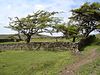 |
Before mid 17th century | The walls surround the churchyard of the former parish church which was demolished in the 1830s. They are in drystone and have an entrance on the west side. To the southeast of the walls is the site where George Fox preached in 1652, known as Fox's pulpit.[2] | II |
| Lincoln's Inn Bridge 54°19′29″N 2°34′04″W / 54.32468°N 2.56767°W |
 |
17th century (probable) | The bridge carries the A684 road over the River Lune. It is in stone, and consists of two segmental arches of unequal span with voussoirs. The pier has triangular cutwaters rising to form triangular buttresses.[3] | II |
| Packhorse bridge 54°21′44″N 2°35′31″W / 54.36211°N 2.59185°W |
 |
17th or 18th century (probable) | The packhorse bridge crosses a stream. It is in stone, and consists of a slightly flattened segmental arch. The bridge has thin voussoirs and low abutments, but no parapets.[4] | II |
| Bridge End and barn 54°19′30″N 2°34′07″W / 54.32491°N 2.56864°W |
—
|
Early 18th century (probable) | The farmhouse and the barn, which dates from the later 18th century, are in stone with slate roofs. The house has two storeys, two bays, an outshut at the right, a gabled porch with a segmental arch, and sash windows. The barn to the left is higher, with quoins, round-headed openings, a doorway, a winnowing door, a loading doorway, and square ventilation holes.[5] | II |
| Hawkrigg and outbuildings 54°19′20″N 2°34′43″W / 54.32220°N 2.57872°W |
—
|
Early 18th century (probable) | The farmhouse and flanking outbuildings are in stone, the house is rendered, and they have a slate roof. The house has two storeys, two bays, a central gabled porch with a segmental-headed entrance, and sash windows. The outbuildings contain doorways, a window, and pitching holes.[6] | II |
| High House Farmhouse 54°21′28″N 2°35′50″W / 54.35768°N 2.59711°W |
—
|
1727 | The farmhouse is in stone with a slate roof, and has two storeys, four bays, and two outshuts at the rear. The second bay has a projecting two-storey porch with a segmental arch, and the fourth bay is recessed. The windows vary; some are casements, one is mullioned, and there is a fire window.[7] | II |
| Cottage north of Moors Farmhouse 54°21′06″N 2°35′15″W / 54.35154°N 2.58752°W |
—
|
1744 | A stone house with a slate roof, two storeys, three bays, and an outbuilding to the left. On the front is a gabled porch with a datestone above, and the windows are mixed, mainly casements. At the rear is a lean-to porch, and the outbuilding has an outshut.[8] | II |
| Underknotts 54°20′17″N 2°34′31″W / 54.33806°N 2.57535°W |
—
|
1749 | A stone house with a slate roof, two storeys with an attic, and five bays. On the front is a gabled porch with a datestone, and the windows are casements. At the rear is a low projection, and a stair window.[9] | II |
| Barn, Underknotts 54°20′17″N 2°34′30″W / 54.33814°N 2.57507°W |
—
|
18th century (probable) | The barn is in stone with a slate roof. It contains a barn entrance, doorways, pigeon holes with sills in a lozenge patterns, windows, ventilation slits, and a winnowing door.[10] | II |
| Milepost approximately 100 metres to west of Bridge End 54°19′28″N 2°34′14″W / 54.32445°N 2.57049°W |
—
|
Early 19th century (probable) | The milepost stands on the route of the Sedbergh to Kendal turnpike road, now the A684 road. It is in stone and has a semicircular plan, set on a square base with broaches. It is inscribed with initials and numbers indicating the distances to Sedbergh and to Kendal.[11] | II |
| Milepost at SD 628 933 54°20′04″N 2°34′20″W / 54.33452°N 2.57222°W |
—
|
Early 19th century (probable) | The milepost stands on the route of the Sedbergh to Grayrigg turnpike road, now the B6257 road. It is in stone and has a semicircular plan, set on a square base with broaches. It is inscribed with initials and numbers indicating the distances to Borrow Bridge and to Kirkby Lonsdale.[12] | II |
| Milepost at SD 624 947 54°20′51″N 2°34′46″W / 54.34744°N 2.57951°W |
—
|
Early 19th century (probable) | The milepost stands on the route of the Sedbergh to Grayrigg turnpike road, now the B6257 road. It is in stone and has a semicircular plan, set on a square base with broaches. It is inscribed with initials and numbers indicating the distances to Borrow Bridge and to Kirkby Lonsdale.[13] | II |
| Milepost at SD 617 961 54°21′33″N 2°35′27″W / 54.35908°N 2.59079°W |
—
|
Early 19th century (probable) | The milepost stands on the route of the Sedbergh to Grayrigg turnpike road, now the B6257 road. It is in stone and has a semicircular plan, set on a square base with broaches. It is inscribed with initials and numbers indicating the distances to Borrow Bridge and to Kirkby Lonsdale.[14] | II |
| St John's Church 54°20′11″N 2°34′25″W / 54.33637°N 2.57369°W |
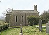 |
1842 | The church is in stone with a top cornice, and a slate roof with coped gables and finials at the east end. It consists of a nave and a chancel with an apse. At the west end is a bell turret with a string course and a projecting embattled parapet. The windows are lancets, and in the apse are three stepped lancets. The entrance at the west end has a pointed arch, and above it is a datestone.[15][16] | II |
| Lune Viaduct 54°19′54″N 2°34′10″W / 54.33168°N 2.56951°W |
 |
1857–61 | The viaduct was built by the London and North Western Railway to carry the Ingleton Branch over the River Lune at a height of 31 metres (102 ft), and was designed by Joseph Locke and John Errington. It has a symmetrical design, with a central segmental cast iron arch flanked by three round-headed sandstone arches, and has a total length of 163 metres (535 ft). The central span is 38 metres (125 ft) long, and has spandrels filled with two tiers of round-headed arches.[17][18] | II* |
References edit
Citations edit
- ^ Historic England
- ^ Historic England & 1086914
- ^ Historic England & 1384063
- ^ Historic England & 1137685
- ^ Historic England & 1312178
- ^ Historic England & 1137710
- ^ Historic England & 1335900
- ^ Historic England & 1137739
- ^ Historic England & 1312161
- ^ Historic England & 1335901
- ^ Historic England & 1086910
- ^ Historic England & 1312169
- ^ Historic England & 1086912
- ^ Historic England & 1312190
- ^ Hyde & Pevsner (2010), p. 349
- ^ Historic England & 1086913
- ^ Hyde & Pevsner (2010), pp. 349–350
- ^ Historic England & 1086911
Sources edit
- Historic England, "Graveyard boundary walls to original Parish Church, Firbank (1086914)", National Heritage List for England, retrieved 15 February 2017
- Historic England, "Lincolns Inn Bridge over the River Lune, Firbank (1384063)", National Heritage List for England, retrieved 15 February 2017
- Historic England, "Packhorse bridge to west of Lowgill Viaduct, Firbank (1137685)", National Heritage List for England, retrieved 15 February 2017
- Historic England, "Bridge End and attached barn, Firbank (1312178)", National Heritage List for England, retrieved 15 February 2017
- Historic England, "Hawkrigg and adjoining outbuildings, Firbank (1137710)", National Heritage List for England, retrieved 15 February 2017
- Historic England, "High House Farmhouse, Firbank (1335900)", National Heritage List for England, retrieved 15 February 2017
- Historic England, "Cottage to north of Moors Farmhouse, Firbank (1137739)", National Heritage List for England, retrieved 15 February 2017
- Historic England, "Underknotts, Firbank (1312161)", National Heritage List for England, retrieved 15 February 2017
- Historic England, "Barn to east of Underknotts, Firbank (1335901)", National Heritage List for England, retrieved 15 February 2017
- Historic England, "Milepost approximately 100 metres to west of Bridge End, Firbank (1086910)", National Heritage List for England, retrieved 15 February 2017
- Historic England, "Milepost at SD 628 933, Firbank (1312169)", National Heritage List for England, retrieved 15 February 2017
- Historic England, "Milepost at SD 624 947, Firbank (1086912)", National Heritage List for England, retrieved 15 February 2017
- Historic England, "Milepost at SD 617 961, Firbank (1312190)", National Heritage List for England, retrieved 15 February 2017
- Historic England, "Church of St John, Firbank (1086913)", National Heritage List for England, retrieved 15 February 2017
- Historic England, "Lune Viaduct at Newbys Dub, Firbank (1086911)", National Heritage List for England, retrieved 15 February 2017
- Historic England, Listed Buildings, retrieved 15 February 2017
- Hyde, Matthew; Pevsner, Nikolaus (2010) [1967], Cumbria, The Buildings of England, New Haven and London: Yale University Press, ISBN 978-0-300-12663-1