


Summary
Myerscough and Bilsborrow is a civil parish in the Wyre district of Lancashire, England. It contains 15 listed buildings that are recorded in the National Heritage List for England. All the listed buildings are designated at Grade II, the lowest of the three grades, which is applied to "buildings of national importance and special interest".[1] The parish contains the village of Bilsborrow, the hamlet of Myerscough, and the surrounding countryside. The Lancaster Canal and the River Brock pass through the parish. Five bridges over the canal and two over the river are listed, together with the aqueduct carrying the canal over the river. The other listed buildings include farmhouses and a farm building, entrance piers and walls, a milestone, a boundary stone, and a country house.
Buildings edit
| Name and location | Photograph | Date | Notes |
|---|---|---|---|
| Brock Side Farmhouse 53°51′50″N 2°43′32″W / 53.86393°N 2.72543°W |
—
|
1733 | A sandstone house with a slate roof, in two storeys and three bays. The windows are cross windows, and the doorway has a quoined surround. Above the doorway is an inscribed plaque.[2] |
| Entrance piers and walls, Myerscough Hall 53°51′17″N 2°44′43″W / 53.85466°N 2.74514°W |
—
|
Mid 18th century | The piers and walls are at the entrance to the drive of Myerscough Hall and are in sandstone. The inner piers flank the drive, they are square and rusticated and have dentilled cornices. Each pier has an Ionic pilaster on the west side. Curved walls link these to the smaller outer piers, which are also square and rusticated, and have pyramidal caps.[3] |
| Milestone 53°51′09″N 2°44′43″W / 53.85251°N 2.74519°W |
—
|
Late 18th century | The milestone is in sandstone and has a half-oval plan. It carries two cast iron plates, one indicating the distance in miles to Garstang, and the other to Preston.[4] |
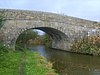
| Hankinson Bridge 53°49′32″N 2°45′01″W / 53.82554°N 2.75014°W |
 |
1797 | This is bridge No. 40, an accommodation bridge over the Lancaster Canal. It is in sandstone and consists of a single elliptical arch. The bridge has a stepped keystone below a solid parapet with a rounded top.[5] |
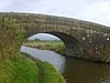
| Park Head Bridge 53°49′41″N 2°45′04″W / 53.82817°N 2.75119°W |
 |
1797 | This is bridge No. 41, an accommodation bridge over the Lancaster Canal. It is in sandstone and consists of a single elliptical arch. The bridge has a stepped keystone below a solid parapet with a rounded top.[6] |
| White Horse Bridge 53°50′15″N 2°44′58″W / 53.83753°N 2.74948°W |
 |
1797 | This is bridge No. 42 over the Lancaster Canal, and carries White Horse Lane over the canal. It is in sandstone and consists of a single elliptical arch. The bridge has a stepped keystone below a solid parapet with a rounded top.[7] |
| Head Nook Bridge 53°50′43″N 2°45′22″W / 53.84522°N 2.75608°W |
 |
1797 | This is bridge No. 43, an accommodation bridge over the Lancaster Canal. It is in sandstone and consists of a single elliptical arch. The bridge has a stepped keystone below a solid parapet with a rounded top.[8] |
| Canal bridge No. 45 53°51′17″N 2°44′45″W / 53.85463°N 2.74590°W |
 |
1797 | This is bridge No. 45 over the Lancaster Canal, and carries Myerscough Hall Drive over the canal. It is in sandstone and consists of a single elliptical arch. The bridge has a stepped keystone below a solid parapet with a rounded top.[9] |
| Brock Aqueduct 53°51′28″N 2°45′08″W / 53.85773°N 2.75219°W |
 |
1797 | This is bridge No. 46, and carries the Lancaster Canal over the River Brock. It is in sandstone and consists of a single low elliptical arch. The walls are concave on plan, and the aqueduct has a moulded cornice under a solid parapet.[10] |
| Lady Whitehead Farmhouse and barn 53°51′07″N 2°43′23″W / 53.85198°N 2.72307°W |
—
|
Early 19th century | The farmhouse and barn are in sandstone with slate roofs. The house has two storeys and two bays. The windows have plain surrounds; those in the left bay are sashes. The doorway also has a plain surround and a canopy of two pitched stone slates. The barn to the right has a wide entrance with a segmental arch, a doorway and a window.[a][11] |
| Methodist Chapel 53°51′09″N 2°44′10″W / 53.85240°N 2.73620°W |
 |
Early 19th century | The Methodist chapel is pebbledashed with a slate roof, and has a single storey and an octagonal plan. Its windows are modern with rendered reveals, and the door has a plain surround. There is a single-storey extension to the west and a lean-to addition to the north.[12][13] |
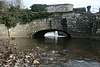
| New Bridge 53°51′47″N 2°43′38″W / 53.86292°N 2.72722°W |
 |
Early 19th century | The bridge carries Lydiate Lane over the River Brock. It is in sandstone and consists of a single elliptical arch. The bridge has voussoirs and a band below a solid parapet.[14] |
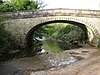
| Walmsley Bridge 53°52′03″N 2°42′37″W / 53.86761°N 2.71024°W |
 |
Early 19th century (probable) | The bridge carries Walmsley Bridge Lane over the River Brock. It is in sandstone and consists of a single elliptical arch. The bridge has voussoirs with alternate rustication, a band, and a solid parapet with coping. The western parapet has two dated inscriptions.[15] |
| Boundary stone 53°51′30″N 2°42′36″W / 53.85838°N 2.70992°W |
—
|
19th century | The boundary stone has a triangular section and a sloping top, and marked the boundaries of the Preston Rural District and the Garstang Rural District. There are inscriptions on the top and the sides.[16] |
| Bilsborough Hall 53°51′18″N 2°43′34″W / 53.85501°N 2.72613°W |
—
|
1913 | A country house that was extended in 1924–27. It is in sandstone with stone-slate roofs, in the style of the late 17th century, and has an irregular plan. Its features include gables, bay windows, and windows that are mullioned or mullioned and transomed. Inside the house are furniture and fittings in 17th-century style, including an inglenook.[12][17] |
Notes and references edit
Notes edit
- ^ Street View in March 2009 shows that the barn has been converted into domestic accommodation.
Citations edit
- ^ Historic England
- ^ Historic England & 1361937
- ^ Historic England & 1163810
- ^ Historic England & 1361960
- ^ Historic England & 1072882
- ^ Historic England & 1072883
- ^ Historic England & 1163825
- ^ Historic England & 1163805
- ^ Historic England & 1163796
- ^ Historic England & 1361959
- ^ Historic England & 1361939
- ^ a b Hartwell & Pevsner (2009), p. 109
- ^ Historic England & 1072912
- ^ Historic England & 1072911
- ^ Historic England & 1361938
- ^ Historic England & 1391234
- ^ Historic England & 1072910
Sources edit
- Hartwell, Clare; Pevsner, Nikolaus (2009) [1969], Lancashire: North, The Buildings of England, New Haven and London: Yale University Press, ISBN 978-0-300-12667-9
- Historic England, "Brock Side Farmhouse, Myerscough and Bilsborrow (1361937)", National Heritage List for England, retrieved 6 December 2015
- Historic England, "Two pairs of piers with linking walls at entrance to drive to Myerscough Hall, Myerscough and Bilsborrow (1163810)", National Heritage List for England, retrieved 6 December 2015
- Historic England, "Milestone, Myerscough and Bilsborrow (1361960)", National Heritage List for England, retrieved 6 December 2015
- Historic England, "Hankinson Bridge (No.40), Myerscough and Bilsborrow (1072882)", National Heritage List for England, retrieved 6 December 2015
- Historic England, "Park Head Bridge (No.41), Myerscough and Bilsborrow (1072883)", National Heritage List for England, retrieved 6 December 2015
- Historic England, "White Horse Bridge (No.42), Myerscough and Bilsborrow (1163825)", National Heritage List for England, retrieved 6 December 2015
- Historic England, "Head Nook Bridge (No.43), Myerscough and Bilsborrow (1163805)", National Heritage List for England, retrieved 6 December 2015
- Historic England, "Canal Bridge (No.45), Myerscough and Bilsborrow (1163796)", National Heritage List for England, retrieved 6 December 2015
- Historic England, "Brock Aqueduct (No.46), Myerscough and Bilsborrow (1361959)", National Heritage List for England, retrieved 6 December 2015
- Historic England, "Lady Whitehead Farmhouse and barn adjoining to west, Myerscough and Bilsborrow (1361939)", National Heritage List for England, retrieved 6 December 2015
- Historic England, "Methodist Chapel, Myerscough and Bilsborrow (1072912)", National Heritage List for England, retrieved 6 December 2015
- Historic England, "New Bridge, Myerscough and Bilsborrow (1072911)", National Heritage List for England, retrieved 6 December 2015
- Historic England, "Walmsley Bridge, Myerscough and Bilsborrow (1361938)", National Heritage List for England, retrieved 6 December 2015
- Historic England, "Boundary Stone, Myerscough and Bilsborrow (1391234)", National Heritage List for England, retrieved 6 December 2015
- Historic England, "Bilsborough Hall, Myerscough and Bilsborrow (1072910)", National Heritage List for England, retrieved 6 December 2015
- Historic England, Listed Buildings, retrieved 6 December 2015