


Summary
Little Tahoma Peak, also called Little Tahoma, is a satellite peak of Mount Rainier in Pierce County, Washington and in Mount Rainier National Park. It is quite noticeable from Seattle over 60 miles (97 km) away.
| Little Tahoma Peak | |
|---|---|
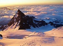 View of Little Tahoma Peak from Ingraham Glacier | |
| Highest point | |
| Elevation | 11,138 ft (3,395 m)[1] |
| Prominence | 818 ft (249 m)[1] |
| Coordinates | 46°50′58″N 121°42′44″W / 46.8495529°N 121.7123171°W[2] |
| Geography | |
| Location | Mount Rainier National Park, Pierce County, Washington, U.S. |
| Parent range | Cascades |
| Topo map | USGS Mount Rainier East |
| Geology | |
| Age of rock | Less than 500,000 years |
| Mountain type | Andesitic stratovolcanic remnant |
| Volcanic arc/belt | Cascade Volcanic Arc |
| Climbing | |
| First ascent | 1894 by JB Flett and Henry H. Garrison [3] |
| Easiest route | Rock & Ice climb |
Little Tahoma Peak is a volcanic remnant. It was part of a larger Mount Rainier which has eroded. The rock is quite unstable and in 1963 a large avalanche originating below it covered the lower section of Emmons Glacier with rock debris. The Fryingpan Glacier and Whitman Glacier are located just to the east of the peak.
Little Tahoma Peak can most easily be accessed from Summerland, an alpine meadow area in Mount Rainier National Park. The first recorded ascent was on August 29, 1894, by JB Flett and Henry H. Garrison who climbed from Summerland using the east shoulder.[3]
If considered on its own, Little Tahoma would be the third-highest peak in Washington.
Climate edit
The summit of Little Tahoma has a Tundra climate, with severely cold winters and cool summers.
| Climate data for Little Tahoma Peak 46.8496 N, 121.7103 W, Elevation: 10,007 ft (3,050 m) (1991–2020 normals) | |||||||||||||
|---|---|---|---|---|---|---|---|---|---|---|---|---|---|
| Month | Jan | Feb | Mar | Apr | May | Jun | Jul | Aug | Sep | Oct | Nov | Dec | Year |
| Mean daily maximum °F (°C) | 22.0 (−5.6) |
21.4 (−5.9) |
22.2 (−5.4) |
26.2 (−3.2) |
34.9 (1.6) |
41.2 (5.1) |
51.5 (10.8) |
52.1 (11.2) |
47.1 (8.4) |
36.8 (2.7) |
25.1 (−3.8) |
20.6 (−6.3) |
33.4 (0.8) |
| Daily mean °F (°C) | 16.7 (−8.5) |
14.7 (−9.6) |
14.5 (−9.7) |
17.3 (−8.2) |
24.9 (−3.9) |
30.6 (−0.8) |
39.5 (4.2) |
40.0 (4.4) |
35.8 (2.1) |
27.6 (−2.4) |
19.3 (−7.1) |
15.6 (−9.1) |
24.7 (−4.0) |
| Mean daily minimum °F (°C) | 11.4 (−11.4) |
8.1 (−13.3) |
6.7 (−14.1) |
8.4 (−13.1) |
14.9 (−9.5) |
19.9 (−6.7) |
27.5 (−2.5) |
28.0 (−2.2) |
24.6 (−4.1) |
18.5 (−7.5) |
13.6 (−10.2) |
10.6 (−11.9) |
16.0 (−8.9) |
| Average precipitation inches (mm) | 21.08 (535) |
18.16 (461) |
16.32 (415) |
11.00 (279) |
6.27 (159) |
4.76 (121) |
1.70 (43) |
1.92 (49) |
4.81 (122) |
11.15 (283) |
19.11 (485) |
20.00 (508) |
136.28 (3,460) |
| Source: PRISM Climate Group[4] | |||||||||||||
References edit
- ^ a b "Little Tahoma, Washington". Peakbagger.com. Retrieved 2008-11-25.
- ^ "Little Tahoma Peak". Geographic Names Information System. United States Geological Survey, United States Department of the Interior. Retrieved 2008-11-25.
- ^ a b Beckey, Fred W. (2000). Cascade Alpine Guide: climbing and high routes, Vol. 1, Columbia River to Stevens Pass (3rd ed.). Mountaineers Books. p. 126. ISBN 978-0-89886-577-6.
- ^ "PRISM Climate Group, Oregon State University". PRISM Climate Group, Oregon State University.
To find the table data on the PRISM website, start by clicking Coordinates (under Location); copy Latitude and Longitude figures from top of table; click Zoom to location; click Precipitation, Minimum temp, Mean temp, Maximum temp; click 30-year normals, 1991-2020; click 800m; click Retrieve Time Series button.
External links edit
 Media related to Little Tahoma (category) at Wikimedia Commons