
KNOWPIA
WELCOME TO KNOWPIA

Loch Hoil 
Summary
Loch Hoil is a small freshwater lochan located between the shallow hills between Strath Braan and Strath Tay valley's in Perth and Kinross. Aberfeldy is located 4.0 miles (6.4 km) to the north. [3][1][2]
| Loch Hoil | |
|---|---|
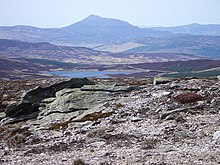
 Loch Hoil from Meall Odhar. The mountains of the Beinn a' Ghlò range are on the skyline. | |
 Loch Hoil | |
| Location | NN86004346 |
| Coordinates | 56°34′12″N 3°51′22″W / 56.56990051°N 3.85611465°W |
| Type | freshwater loch |
| Primary outflows | Cochill Burn |
| Catchment area | 114 ha (280 acres) |
| Max. length | 0.33 km (0.21 mi)[1] |
| Max. width | 0.14 km (0.087 mi)[1] |
| Surface area | 14 ha (35 acres)[2] |
| Average depth | 19 ft (5.8 m)[1] |
| Max. depth | 45 ft (14 m)[1] |
| Water volume | 29,271,000 cu ft (828,900 m3)[1] |
| Shore length1 | 2 km (1.2 mi) [2] |
| Surface elevation | 496 m (1,627 ft)[2] |
| Max. temperature | 57 °F (14 °C) |
| Min. temperature | 47 °F (8 °C) |
| Islands | 0 |
| 1 Shore length is not a well-defined measure. | |
See also edit
Gallery edit
-
 Boathouse, Loch Hoil This hut hasn't really slipped into the water, as it appears here. From the side it can be seen as standing on short posts.
 -
 View towards Loch Hoil Looking down from the track towards Loch Hoil, with Schiehallion on the skyline to the left.
 -
 Fishing hut, Loch Hoil Taken in mist.
 -
 Schiehallion from Meall Dearg. Looking north-west from the stony plateau of Meall Dearg there is a good view of Schiehallion beyond Loch Hoil and the Tay valley.
 -
 View from Meall Odhar ridge Looking down the heathery slopes of Meall Odhar, with Loch Hoil below. A vast area of forestry extends north-eastwards beyond the loch. Relatively modest hills often have excellent views and this is no exception.


References edit
- ^ a b c d e f John, Murray; Lawrence, Pullar. Bathymetrical Survey of the Fresh-Water Lochs of Scotland, 1897–1909 Lochs of the Tay Basin Volume II – Loch Hoil. p. 114. Retrieved 24 September 2020.
 This article incorporates text from this source, which is in the public domain.
- ^ a b c d "Loch Hoil". Centre for Ecology and Hydrology. Scotland and Northern Ireland Forum for Environmental Research (SNIFFER). Retrieved 24 September 2020.
- ^ Gittings, Bruce; Munro, David. "Hoil, Loch". The Gazetteer for Scotland. School of GeoSciences, University of Edinburgh and The Royal Scottish Geographical Society. Retrieved 24 September 2020.