


Summary
Lomonosov is a crater on Mars, with a diameter close to 150 km. It is located in the Martian northern plains. Since it is large and found close (64.9° north) to the boundary between the Mare Acidalium quadrangle and the Mare Boreum quadrangle, it is found on both maps. The topography is smooth and young in this area, hence Lomonosov is easy to spot on large maps of Mars.
 | |
| Planet | Mars |
|---|---|
| Coordinates | 64°54′N 9°12′W / 64.9°N 9.2°W |
| Quadrangle | Mare Acidalium |
| Diameter | 150 km |
| Eponym | Mikhail V. Lomonosov |
The crater was named in 1973 in honour of Mikhail V. Lomonosov.
The impact that created the crater has been identified as a possible source of tsunami waves which washed the shores of an ancient ocean formerly present in the basin Vastitas Borealis.[1][2][3] In July 2019, further support was reported for an ancient ocean on Mars that may have been formed by a possible mega-tsunami source resulting from a meteorite impact creating Lomonosov crater.[4][5]
Gallery edit
-
 Mosaic of Viking Oribiter 1 images, with Lomonosov at top and looking south.
 -
 Polygonial patterned ground in the interior of Lomonosov, as seen by Mars Global Surveyor.
 -
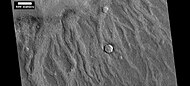 Channels made by the backwash from tsunamis, as seen by HiRISE. Tsunamis were probably caused by asteroids striking the ocean.


Interactive Mars map edit

See also edit
- 1379 Lomonosowa, asteroid
References edit
- ^ Rincon, P. (2017-03-26). "Impact crater linked to Martian tsunamis". BBC. Retrieved 2017-03-26.
- ^ Costard, F.; Séjourné, A.; Kelfoun, K.; Clifford, S.; Lavigne, F.; Di Pietro, I.; Bouley, S. (2017). "Modelling Investigation of Tsunamis on Mars" (PDF). Lunar and Planetary Science XLVIII. The Woodlands, Texas: Lunar and Planetary Institute. p. 1171. Retrieved 2017-03-26.
- ^ Costard, F., et al. 2018. Formation of the Northern Plains Lomonosov Crater During a Tsunami Generating Marine Impact Event. 49th Lunar and Planetary Science Conference 2018 (LPI Contrib. No. 2083). 1928.pdf
- ^ Andrews, Robin George (30 July 2019). "When a Mega-Tsunami Drowned Mars, This Spot May Have Been Ground Zero - The 75-mile-wide crater could be something like a Chicxulub crater for the red planet". The New York Times. Retrieved 31 July 2019.
- ^ Costard, F.; et al. (26 June 2019). "The Lomonosov Crater Impact Event: A Possible Mega-Tsunami Source on Mars". Journal of Geophysical Research: Planets. 124 (7): 1840–1851. Bibcode:2019JGRE..124.1840C. doi:10.1029/2019JE006008. hdl:20.500.11937/76439. S2CID 198401957.
External links edit
- crater Google Mars linked to the crater Lomonosov
- MGS MOC Release No. MOC2-226, 27 April 2000