


Summary
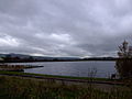
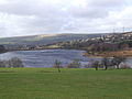
The Longdendale Chain is a sequence of six reservoirs on the River Etherow in the Longdendale Valley, in northern Derbyshire. They were constructed between 1848 and 1884 to a design by John Frederick Bateman to supply the growing population of Manchester and Salford with fresh water.[1]


The top three reservoirs (Woodhead, Torside and Rhodeswood) and Arnfield are for drinking water, and the lower reservoirs (Valehouse and Bottoms) are used as compensation reservoirs to maintain the downstream flow of the river. There was originally a seventh – Hollingworth Reservoir – which was abandoned in 1990, and has become part of the Swallows Wood nature reserve.[2][3]
Water flowed by gravity through the Mottram Tunnel to the Godley covered reservoir where it drops to the service reservoirs at Denton, Audenshaw, Gorton and Prestwich.[3]
Reservoirs edit
The reservoirs are listed from upstream to downstream i.e. from east to west:
- Woodhead Reservoir
- Torside Reservoir
- Rhodeswood Reservoir
- Valehouse Reservoir
- Bottoms Reservoir
- Arnfield Reservoir


See also edit
References edit
Notes edit
- ^ "A Tribute to John Frederick La Trobe Bateman 1810–1889". Tameside MBC web pages. Tameside Council. 12 September 2007. Archived from the original on 20 August 2008. Retrieved 8 August 2008.
- ^ "Longendale in the Peak National Park". PDNP Education Website. Peak District National Park Authority. 2000. Archived from the original on 4 January 2006. Retrieved 8 August 2008.
- ^ a b Quayle, Tom (2006). Manchester's water: the reservoirs in the hills. Stroud: Tempus. ISBN 0-7524-3198-6. p. 120.
Bibliography edit
Quayle, Tom (2006). Manchester's water: the reservoirs in the hills. Stroud: Tempus. ISBN 0-7524-3198-6.
Mansergh, James (1878). The Thirlmere water scheme of the Manchester Corporation : with a few remarks on the Longdendale Works, and water-supply generally. London: Spon. - popularising lecture, with copious plans & elevations (of Longendale chain as well as Thirlmere scheme)
53°29′34″N 1°51′51″W / 53.4927°N 1.8642°W