
KNOWPIA
WELCOME TO KNOWPIA

Loperhet 
Summary
Loperhet (French pronunciation: [lɔpeʁɛt]; also Lopérhet; Breton: Loperc'hed) is a commune in the Finistère department of Brittany in north-western France.
Loperhet
Loperc'hed | |
|---|---|
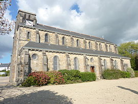 The parish church of Sainte-Brigitte | |
 Coat of arms | |
Location of Loperhet .mw-parser-output .locmap .od{position:absolute}.mw-parser-output .locmap .id{position:absolute;line-height:0}.mw-parser-output .locmap .l0{font-size:0;position:absolute}.mw-parser-output .locmap .pv{line-height:110%;position:absolute;text-align:center}.mw-parser-output .locmap .pl{line-height:110%;position:absolute;top:-0.75em;text-align:right}.mw-parser-output .locmap .pr{line-height:110%;position:absolute;top:-0.75em;text-align:left}.mw-parser-output .locmap .pv>div{display:inline;padding:1px}.mw-parser-output .locmap .pl>div{display:inline;padding:1px;float:right}.mw-parser-output .locmap .pr>div{display:inline;padding:1px;float:left}html.skin-theme-clientpref-night .mw-parser-output .od,html.skin-theme-clientpref-night .mw-parser-output .od .pv>div,html.skin-theme-clientpref-night .mw-parser-output .od .pl>div,html.skin-theme-clientpref-night .mw-parser-output .od .pr>div{background:#000;color:#fff}html.skin-theme-clientpref-night .mw-parser-output .locmap{filter:grayscale(0.6)}@media(prefers-color-scheme:dark){html.skin-theme-clientpref-os .mw-parser-output .locmap{filter:grayscale(0.6)}html.skin-theme-clientpref-os .mw-parser-output .od,html.skin-theme-clientpref-os .mw-parser-output .od .pv>div,html.skin-theme-clientpref-os .mw-parser-output .od .pl>div,html.skin-theme-clientpref-os .mw-parser-output .od .pr>div{background:#000;color:#fff}}  Loperhet  Loperhet | |
| Coordinates: 48°22′32″N 4°18′14″W / 48.3756°N 4.3039°W | |
| Country | France |
| Region | Brittany |
| Department | Finistère |
| Arrondissement | Brest |
| Canton | Pont-de-Buis-lès-Quimerch |
| Intercommunality | CA Pays de Landerneau-Daoulas |
| Government | |
| • Mayor (2020–2026) | Nathalie Godet[1] |
| Area 1 | 20.31 km2 (7.84 sq mi) |
| Population (2021)[2] | 3,951 |
| • Density | 190/km2 (500/sq mi) |
| Time zone | UTC+01:00 (CET) |
| • Summer (DST) | UTC+02:00 (CEST) |
| INSEE/Postal code | 29140 /29470 |
| Elevation | 0–162 m (0–531 ft) |
| 1 French Land Register data, which excludes lakes, ponds, glaciers > 1 km2 (0.386 sq mi or 247 acres) and river estuaries. | |
Population edit
Inhabitants of Loperhet are called in French Loperhétois.
| Year | Pop. | ±% p.a. |
|---|---|---|
| 1968 | 1,315 | — |
| 1975 | 1,411 | +1.01% |
| 1982 | 2,030 | +5.33% |
| 1990 | 2,941 | +4.74% |
| 1999 | 3,466 | +1.84% |
| 2007 | 3,530 | +0.23% |
| 2012 | 3,602 | +0.40% |
| 2017 | 3,760 | +0.86% |
| Source: INSEE[3] | ||
Breton language edit
The municipality launched a linguistic plan concerning the Breton language through Ya d'ar brezhoneg on 22 October 2008.
In 2008, 14.56% of primary-school children attended bilingual schools.[4]
See also edit
References edit
- ^ "Répertoire national des élus: les maires". data.gouv.fr, Plateforme ouverte des données publiques françaises (in French). 9 August 2021.
- ^ "Populations légales 2021". The National Institute of Statistics and Economic Studies. 28 December 2023.
- ^ Population en historique depuis 1968, INSEE
- ^ (in French) Ofis ar Brezhoneg: Enseignement bilingue
External links edit
Wikimedia Commons has media related to Loperhet.
- Official website (in French)
- Base Mérimée: Search for heritage in the commune, Ministère français de la Culture. (in French)
- Mayors of Finistère Association (in French)