


Summary
Loqueffret (French pronunciation: [lɔkefʁɛt]; Breton: Lokeored) is a commune in the Finistère department of Brittany in north-western France.
Loqueffret
Lokeored | |
|---|---|
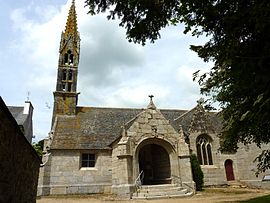 The church of Sainte-Geneviève, in Loqueffret | |
Location of Loqueffret .mw-parser-output .locmap .od{position:absolute}.mw-parser-output .locmap .id{position:absolute;line-height:0}.mw-parser-output .locmap .l0{font-size:0;position:absolute}.mw-parser-output .locmap .pv{line-height:110%;position:absolute;text-align:center}.mw-parser-output .locmap .pl{line-height:110%;position:absolute;top:-0.75em;text-align:right}.mw-parser-output .locmap .pr{line-height:110%;position:absolute;top:-0.75em;text-align:left}.mw-parser-output .locmap .pv>div{display:inline;padding:1px}.mw-parser-output .locmap .pl>div{display:inline;padding:1px;float:right}.mw-parser-output .locmap .pr>div{display:inline;padding:1px;float:left}html.skin-theme-clientpref-night .mw-parser-output .od,html.skin-theme-clientpref-night .mw-parser-output .od .pv>div,html.skin-theme-clientpref-night .mw-parser-output .od .pl>div,html.skin-theme-clientpref-night .mw-parser-output .od .pr>div{background:#000;color:#fff}html.skin-theme-clientpref-night .mw-parser-output .locmap{filter:grayscale(0.6)}@media(prefers-color-scheme:dark){html.skin-theme-clientpref-os .mw-parser-output .locmap{filter:grayscale(0.6)}html.skin-theme-clientpref-os .mw-parser-output .od,html.skin-theme-clientpref-os .mw-parser-output .od .pv>div,html.skin-theme-clientpref-os .mw-parser-output .od .pl>div,html.skin-theme-clientpref-os .mw-parser-output .od .pr>div{background:#000;color:#fff}}  Loqueffret  Loqueffret | |
| Coordinates: 48°19′20″N 3°51′14″W / 48.3222°N 3.8539°W | |
| Country | France |
| Region | Brittany |
| Department | Finistère |
| Arrondissement | Châteaulin |
| Canton | Carhaix-Plouguer |
| Government | |
| • Mayor (2020–2026) | Marcel Salaün[1] |
| Area 1 | 27.40 km2 (10.58 sq mi) |
| Population (2021)[2] | 340 |
| • Density | 12/km2 (32/sq mi) |
| Time zone | UTC+01:00 (CET) |
| • Summer (DST) | UTC+02:00 (CEST) |
| INSEE/Postal code | 29141 /29530 |
| Elevation | 87–297 m (285–974 ft) |
| 1 French Land Register data, which excludes lakes, ponds, glaciers > 1 km2 (0.386 sq mi or 247 acres) and river estuaries. | |
Located south of the monts d ' Arrée, in the eastern part of the Armorique regional natural park, it is a small rural village, former home of the Pilhaouers. Covering 2 770 hectares, the commune had in 2006 of 406 inhabitants. Served by a dense drainage network, it presents two distinct part geographical entities and other sandstone of the monts d ' Arrée domes: northern slopes covered wildfires down towards Lake Saint-Michel, South of the slopes in crops or afforested, more conducive to agricultural soils.
"The parish church, the chapel of the cross and the Manor of du Rusquec remain important heritage sites, while the quality and variety of natural sites, paths and panoramas favour activities related to tourism rural
Population edit
Inhabitants of Loqueffret are called in French Loqueffretois. In 1884 the commune of Brennilis was separated from Loqueffret.[3]
|
| ||||||||||||||||||||||||||||||||||||||||||||||||||||||||||||||||||||||||||||||||||||||||||||||||||||||||||||||||||
| Source: EHESS[3] and INSEE (1968-2017)[4] | |||||||||||||||||||||||||||||||||||||||||||||||||||||||||||||||||||||||||||||||||||||||||||||||||||||||||||||||||||
See also edit


References edit
- ^ "Répertoire national des élus: les maires". data.gouv.fr, Plateforme ouverte des données publiques françaises (in French). 2 December 2020.
- ^ "Populations légales 2021". The National Institute of Statistics and Economic Studies. 28 December 2023.
- ^ a b Des villages de Cassini aux communes d'aujourd'hui: Commune data sheet Loqueffret, EHESS (in French).
- ^ Population en historique depuis 1968, INSEE
External links edit
- Official website (in French)
- Base Mérimée: Search for heritage in the commune, Ministère français de la Culture. (in French)
- Mayors of Finistère Association (in French)