
KNOWPIA
WELCOME TO KNOWPIA

Lourmais 
Summary
Lourmais (French pronunciation: [luʁmɛ]; Gallo: L’Oumàe, Breton: An Oulmeg) is a commune in the Ille-et-Vilaine department of Brittany in northwestern France.
Lourmais
| |
|---|---|
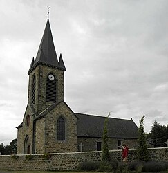 The church of Sainte-Anne, in Lourmais | |
Location of Lourmais .mw-parser-output .locmap .od{position:absolute}.mw-parser-output .locmap .id{position:absolute;line-height:0}.mw-parser-output .locmap .l0{font-size:0;position:absolute}.mw-parser-output .locmap .pv{line-height:110%;position:absolute;text-align:center}.mw-parser-output .locmap .pl{line-height:110%;position:absolute;top:-0.75em;text-align:right}.mw-parser-output .locmap .pr{line-height:110%;position:absolute;top:-0.75em;text-align:left}.mw-parser-output .locmap .pv>div{display:inline;padding:1px}.mw-parser-output .locmap .pl>div{display:inline;padding:1px;float:right}.mw-parser-output .locmap .pr>div{display:inline;padding:1px;float:left}html.skin-theme-clientpref-night .mw-parser-output .od,html.skin-theme-clientpref-night .mw-parser-output .od .pv>div,html.skin-theme-clientpref-night .mw-parser-output .od .pl>div,html.skin-theme-clientpref-night .mw-parser-output .od .pr>div{background:#000;color:#fff}html.skin-theme-clientpref-night .mw-parser-output .locmap{filter:grayscale(0.6)}@media(prefers-color-scheme:dark){html.skin-theme-clientpref-os .mw-parser-output .locmap{filter:grayscale(0.6)}html.skin-theme-clientpref-os .mw-parser-output .od,html.skin-theme-clientpref-os .mw-parser-output .od .pv>div,html.skin-theme-clientpref-os .mw-parser-output .od .pl>div,html.skin-theme-clientpref-os .mw-parser-output .od .pr>div{background:#000;color:#fff}}  Lourmais  Lourmais | |
| Coordinates: 48°27′02″N 1°43′35″W / 48.4506°N 1.7264°W | |
| Country | France |
| Region | Brittany |
| Department | Ille-et-Vilaine |
| Arrondissement | Saint-Malo |
| Canton | Combourg |
| Intercommunality | CC Bretagne Romantique |
| Government | |
| • Mayor (2020–2026) | François Bordin[1] |
| Area 1 | 7.22 km2 (2.79 sq mi) |
| Population (2021)[2] | 329 |
| • Density | 46/km2 (120/sq mi) |
| Time zone | UTC+01:00 (CET) |
| • Summer (DST) | UTC+02:00 (CEST) |
| INSEE/Postal code | 35159 /35270 |
| Elevation | 60–111 m (197–364 ft) |
| 1 French Land Register data, which excludes lakes, ponds, glaciers > 1 km2 (0.386 sq mi or 247 acres) and river estuaries. | |
Population edit
Inhabitants of Lourmais are called Lourmaisiens in French.
| Year | Pop. | ±% |
|---|---|---|
| 1962 | 255 | — |
| 1968 | 262 | +2.7% |
| 1975 | 261 | −0.4% |
| 1982 | 263 | +0.8% |
| 1990 | 274 | +4.2% |
| 1999 | 251 | −8.4% |
| 2008 | 317 | +26.3% |
See also edit
References edit
- ^ "Répertoire national des élus: les maires". data.gouv.fr, Plateforme ouverte des données publiques françaises (in French). 9 August 2021.
- ^ "Populations légales 2021". The National Institute of Statistics and Economic Studies. 28 December 2023.
External links edit
Wikimedia Commons has media related to Lourmais.
- Base Mérimée: Search for heritage in the commune, Ministère français de la Culture. (in French)
- Mayors of Ille-et-Vilaine Association (in French)