


Summary
Lower Earley is a suburb which forms the southern portion of the civil parish of Earley in the Borough of Wokingham in Berkshire, England. Along with neighbouring Earley, Winnersh, Woodley and Shinfield, It forms part of a part of the Reading/Wokingham Urban Area.
| Lower Earley | |
|---|---|
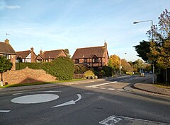 Rushey Way, Lower Earley | |
 Lower Earley Location within Berkshire | |
| Population | 32,036 (2001) |
| OS grid reference | SU742699 |
| Civil parish | |
| Unitary authority | |
| Ceremonial county | |
| Region | |
| Country | England |
| Sovereign state | United Kingdom |
| Post town | READING |
| Postcode district | RG6 |
| Dialling code | 0118 |
| Police | Thames Valley |
| Fire | Royal Berkshire |
| Ambulance | South Central |
| UK Parliament | |
History edit
Lower Earley was the part of Earley liberty in Sonning parish[1] beside the River Loddon. It mostly consisted of Earley Upper Common and Lower Wood Common and a number of farms.[2] From 1977, the Lower Earley private estate was constructed. Three new primary schools were built (Hawkedon, Hillside Primary School and Radstock Primary School), together with a large supermarket complex, which opened in 1979, and a sports centre. In 1988, a second shopping area, Maiden Place, opened.[3]

Facilities edit
Schools edit
There are three primary schools in Lower Earley, Hawkedon Primary School, Hillside Primary School and Radstock Primary School. An additional secondary school was planned roughly opposite the sports centre next to Rushey Way, possibly on the site next to the police station. However the school never materialised, and the land was built on.[3] The main secondary schools that students from the area attend are The Bulmershe School, Maiden Erlegh School, The Forest School , The Emmbrook School and The Holt School, as well as some students attending the local single-sex grammar schools, Reading School and Kendrick School. There is also a pre-school next to Chalfont Park.
Retail facilities edit
The Maiden Place Shopping Precinct was opened in 1988 on Kilnsea Drive.
Local Nature Reserve edit
There is a local nature reserve called Pearman's Copse within the borders of Lower Earley.[4]
Transport edit
Public transport edit
Earley railway station is not close to Lower Earley, as it is nearly 2 miles away. Instead, it serves Earley and the town of Woodley.
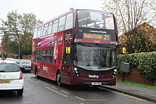
Lower Earley has two main bus links to Central Reading, the 21, and 19b, run by Reading Buses. Service 21 runs 24 hours a day, seven days a week, starting from Kilnsea Drive to Reading Station via the University. The 19b runs every 60 minutes (Monday to Saturday) from Asda/Bradmore Way to Reading Station via the Royal Berkshire Hospital.[5] There is also the 919 route which goes from Lower Earley to Reading School.
Strategic road network edit
The M4 motorway runs directly to the south of Lower Earley, with Junction 11 being the nearest junction. This major road serves places between London and Swansea, including Swindon, Bristol and Cardiff.
The Lower Earley Way connects the suburb to the A327 (for Reading, or Shinfield and Arborfield) and the A329 (for Reading, or Winnersh and Wokingham) roads, as well as to the A329(M) motorway (for Bracknell).
References edit
- ^ Ford, David Nash (2020). Mid-Berkshire Town and Village Histories. Wokingham: Nash Ford Publishing. p. 91. ISBN 978-1-905191-02-4.
- ^ Ford, David Nash (2020). Mid-Berkshire Town and Village Histories. Wokingham: Nash Ford Publishing. p. 143. ISBN 978-1-905191-02-4.
- ^ a b "Wikimapia - Lower Earley". Wikimapia.
- ^ "Natural England - Special Sites". Lnr.naturalengland.org.uk. Retrieved 30 April 2017.
- ^ "Reading Buses". Reading Buses.