


Summary
Luang Namtha (Luang Nam Tha) (Lao: ມ. ຫລວງນໍ້າທາ) is a district as well as the capital of Luang Namtha Province in northern Laos. The city lies on the Tha River (Nam Tha).
Luang Namtha
ຫລວງນໍ້າທາ | |
|---|---|
| Namtha District | |
 | |
 Luang Namtha Location in Laos | |
| Coordinates: 20°57′N 101°24′E / 20.950°N 101.400°E | |
| Country | |
| Admin. division | Luang Namtha Province |
| Population (2015)[1] | |
| • Total | 54,100 |
| • Religions | Buddhism |
| Time zone | UTC+7 (ICT) |
Luang Namtha is a popular tourist destination, and a base for treks, biking to the surrounding hill tribe villages. The Luang Namtha Museum is in the town.
History edit
From January through May 1962, troops from the Royal Lao Army (RLA) fought the Pathet Lao and People's Army of Vietnam in the Battle of Luang Namtha. The battle ended with the RLA's headlong retreat southward 150 kilometers across the Mekong River.[2]
Climate edit
| Climate data for Luang Namtha (1990–2019) | |||||||||||||
|---|---|---|---|---|---|---|---|---|---|---|---|---|---|
| Month | Jan | Feb | Mar | Apr | May | Jun | Jul | Aug | Sep | Oct | Nov | Dec | Year |
| Mean daily maximum °C (°F) | 26.2 (79.2) |
28.9 (84.0) |
31.0 (87.8) |
32.3 (90.1) |
31.4 (88.5) |
31.1 (88.0) |
30.0 (86.0) |
30.1 (86.2) |
30.5 (86.9) |
29.6 (85.3) |
27.6 (81.7) |
25.2 (77.4) |
29.5 (85.1) |
| Mean daily minimum °C (°F) | 12.3 (54.1) |
12.1 (53.8) |
14.6 (58.3) |
18.4 (65.1) |
20.9 (69.6) |
22.8 (73.0) |
22.8 (73.0) |
22.6 (72.7) |
21.8 (71.2) |
19.9 (67.8) |
16.4 (61.5) |
13.6 (56.5) |
18.2 (64.7) |
| Average precipitation mm (inches) | 26 (1.0) |
24 (0.9) |
56 (2.2) |
108 (4.3) |
201 (7.9) |
190 (7.5) |
294 (11.6) |
307 (12.1) |
172 (6.8) |
94 (3.7) |
58 (2.3) |
31 (1.2) |
1,561 (61.5) |
| Source: Food and Agriculture Organization of the United Nations[3] | |||||||||||||
Transport edit
In the rainy season, Luang Namtha can be reached by boat from the Mekong River. It is connected by Highway 3 to both the Thai border at Houayxay-Chiang Khong (197 km (122 mi)), the Chinese border at Boten-Mengla County (60 km (37 mi)), and the Burmese border at Xieng Kok-Kenglat.[4] Luang Namtha is also served by Louang Namtha Airport, 6 km (3.7 mi) south of the city.
Gallery edit

-
 Day market
 -
 Night market
 -
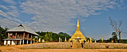
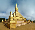 Luang Namtha stupa
 -
 Harvesting rice
 -
 Riverside guesthouse


References edit
- ^ "Results of Population and Housing Census 2015" (PDF). Lao Statistics Bureau. Retrieved 19 February 2024.
- ^ Conboy, Kenneth; Morrison, James (1995). Shadow War: The CIA's Secret War in Laos. Paladin Press. pp. 67–73. ISBN 0-87364-825-0. Retrieved 31 May 2020.
- ^ "Climatology and agroclimatology atlas of the Lao People's Democratic Republic" (PDF). Food and Agriculture Organization of the United Nations. Archived from the original (PDF) on 17 March 2024. Retrieved 17 March 2024.
- ^ Thu, Ei Ei (8 November 2018). "Myanmar-Laos border gate receives international status". Myanmar Times. Archived from the original on 2021-01-29. Retrieved 19 September 2020.
External links edit
 Media related to Luang Namtha at Wikimedia Commons
 Luang Namtha travel guide from Wikivoyage
- Biodiversity Profile for Luang Namtha Province, 2003(subscription required)
- Ethnic diversity in Luang Namtha - Laos
- Facebook photo gallery(subscription required)