
KNOWPIA
WELCOME TO KNOWPIA

Lucayan National Park 
Summary
Lucayan National Park is a national park in Grand Bahama, the Bahamas. The park was established in 1982 and has a land area of 40 acres (16 ha), and 1,937 acres (7.84 km2) in total.[1][2] The park contains an underwater cave system with 6.4 mi (10.3 km) of charted tunnels.[3]
| Lucayan National Park | |
|---|---|
 | |
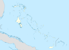 Lucayan National Park The location of Lucayan National Park within the Bahamas | |
| Location | Grand Bahama, the Bahamas |
| Nearest city | Freeport |
| Coordinates | 26°36′13″N 78°24′06″W / 26.6035°N 78.4017°W[1] |
| Area | 40 acres (16 ha) (land); 1,937 acres (7.84 km2) (total) |
| Established | March 1982[2] |
| Governing body | Bahamas National Trust |
| bnt | |
Flora and fauna edit
Prior to the creation of the park, the area was the site of the discovery of the Remipedia class of crustaceans, in the late 1970s.[2] The park is also an Important Bird Area, providing habitat for the thick-billed vireo, Bahama swallow and the olive-capped warbler, among others.[2][4][5]
References edit
- ^ a b c "Lucayan National Park in Bahamas". Protected Planet. Retrieved 3 January 2019.
- ^ a b c d "Lucayan National Park". The Bahamas National Trust. Retrieved 3 January 2019.
- ^ "Exploration". People of the Water. Retrieved 31 January 2023.
- ^ "Lucayan National Park - Data table and detailed info". BirdLife International. Retrieved 3 January 2019.
- ^ "Lucayan National Park - Text account". BirdLife International. Retrieved 3 January 2019.