
KNOWPIA
WELCOME TO KNOWPIA

Luuk, Sulu 
Summary
Luuk, officially the Municipality of Luuk (Tausūg: Kawman sin Luuk; Tagalog: Bayan ng Luuk), is a 3rd class municipality in the province of Sulu, Philippines. According to the 2020 census, it has a population of 37,873 people.[3]
Luuk
لواوق | |
|---|---|
| Municipality of Luuk | |
 Seal | |
 Map of Sulu with Luuk highlighted | |
OpenStreetMap .mw-parser-output .locmap .od{position:absolute}.mw-parser-output .locmap .id{position:absolute;line-height:0}.mw-parser-output .locmap .l0{font-size:0;position:absolute}.mw-parser-output .locmap .pv{line-height:110%;position:absolute;text-align:center}.mw-parser-output .locmap .pl{line-height:110%;position:absolute;top:-0.75em;text-align:right}.mw-parser-output .locmap .pr{line-height:110%;position:absolute;top:-0.75em;text-align:left}.mw-parser-output .locmap .pv>div{display:inline;padding:1px}.mw-parser-output .locmap .pl>div{display:inline;padding:1px;float:right}.mw-parser-output .locmap .pr>div{display:inline;padding:1px;float:left}html.skin-theme-clientpref-night .mw-parser-output .od,html.skin-theme-clientpref-night .mw-parser-output .od .pv>div,html.skin-theme-clientpref-night .mw-parser-output .od .pl>div,html.skin-theme-clientpref-night .mw-parser-output .od .pr>div{background:#000;color:#fff}html.skin-theme-clientpref-night .mw-parser-output .locmap{filter:grayscale(0.6)}@media(prefers-color-scheme:dark){html.skin-theme-clientpref-os .mw-parser-output .locmap{filter:grayscale(0.6)}html.skin-theme-clientpref-os .mw-parser-output .od,html.skin-theme-clientpref-os .mw-parser-output .od .pv>div,html.skin-theme-clientpref-os .mw-parser-output .od .pl>div,html.skin-theme-clientpref-os .mw-parser-output .od .pr>div{background:#000;color:#fff}}  Luuk Location within the Philippines | |
| Coordinates: 5°58′03″N 121°18′48″E / 5.967575°N 121.313308°E | |
| Country | Philippines |
| Region | Bangsamoro Autonomous Region in Muslim Mindanao |
| Province | Sulu |
| District | 2nd district |
| Barangays | 12 (see Barangays) |
| Government | |
| • Type | Sangguniang Bayan |
| • Mayor | Maryam N. Arbison |
| • Vice Mayor | Arnel N. Arbison |
| • Representative | Munir N. Arbison Jr. |
| • Municipal Council | Members |
| • Electorate | 25,352 voters (2022) |
| Area | |
| • Total | 313.04 km2 (120.87 sq mi) |
| Elevation | 72 m (236 ft) |
| Highest elevation | 333 m (1,093 ft) |
| Lowest elevation | 0 m (0 ft) |
| Population (2020 census)[3] | |
| • Total | 37,873 |
| • Density | 120/km2 (310/sq mi) |
| • Households | 6,554 |
| Economy | |
| • Income class | 3rd municipal income class |
| • Poverty incidence | 78.31 |
| • Revenue | ₱ 121 million (2020) |
| • Assets | ₱ 103.2 million (2020) |
| • Expenditure | ₱ 113.7 million (2020) |
| • Liabilities | ₱ 27.14 million (2020) |
| Service provider | |
| • Electricity | Sulu Electric Cooperative (SULECO) |
| Time zone | UTC+8 (PST) |
| ZIP code | 7404 |
| PSGC | 156604000 |
| IDD : area code | +63 (0)68 |
| Native languages | Tausug Tagalog |
| Website | www |
On July 14, 2007, 8 of its barangays were constituted into the separate municipality of Omar, Sulu.
History edit
Luuk was the main site of the violent Kamlon Revolt in 1951. This municipality was once a warzone where the government forces and the Muslim rebels would engage frequently for a span of 5–7 years.
Geography edit
Barangays edit
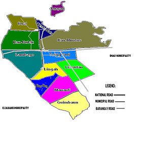
Luuk is politically subdivided into 12 barangays. Each barangay consists of puroks while some have sitios.
- Bual
- Guimbaun
- Kan-Bulak
- Kan-Mindus
- Lambago
- Lianutan
- Lingah
- Mananti
- Niog-niog
- Tandu-Bato
- Tubig-Puti (Poblacion)
- Tulayan Island
Climate edit
| Climate data for Luuk, Sulu | |||||||||||||
|---|---|---|---|---|---|---|---|---|---|---|---|---|---|
| Month | Jan | Feb | Mar | Apr | May | Jun | Jul | Aug | Sep | Oct | Nov | Dec | Year |
| Mean daily maximum °C (°F) | 27 (81) |
27 (81) |
27 (81) |
28 (82) |
28 (82) |
28 (82) |
28 (82) |
28 (82) |
28 (82) |
28 (82) |
28 (82) |
28 (82) |
28 (82) |
| Mean daily minimum °C (°F) | 27 (81) |
26 (79) |
27 (81) |
27 (81) |
28 (82) |
28 (82) |
27 (81) |
27 (81) |
27 (81) |
27 (81) |
27 (81) |
27 (81) |
27 (81) |
| Average precipitation mm (inches) | 152 (6.0) |
120 (4.7) |
125 (4.9) |
132 (5.2) |
239 (9.4) |
301 (11.9) |
281 (11.1) |
268 (10.6) |
190 (7.5) |
263 (10.4) |
234 (9.2) |
179 (7.0) |
2,484 (97.9) |
| Average rainy days | 17.4 | 14.9 | 15.8 | 15.4 | 22.7 | 24.4 | 25.0 | 23.5 | 20.5 | 22.7 | 21.2 | 18.7 | 242.2 |
| Source: Meteoblue (modeled/calculated data, not measured locally)[5] | |||||||||||||
Demographics edit
| Year | Pop. | ±% p.a. |
|---|---|---|
| 1903 | 700 | — |
| 1918 | 18,351 | +24.33% |
| 1939 | 27,878 | +2.01% |
| 1948 | 16,726 | −5.52% |
| 1960 | 18,852 | +1.00% |
| 1970 | 26,860 | +3.60% |
| 1975 | 21,354 | −4.50% |
| 1980 | 19,669 | −1.63% |
| 1990 | 29,378 | +4.09% |
| 1995 | 31,705 | +1.44% |
| 2000 | 38,819 | +4.44% |
| 2007 | 33,508 | −2.01% |
| 2010 | 29,897 | −4.06% |
| 2015 | 32,162 | +1.40% |
| 2020 | 37,873 | +3.27% |
| Source: Philippine Statistics Authority[6][7][8] | ||
Economy edit
References edit
- ^ Municipality of Luuk | (DILG)
- ^ "2015 Census of Population, Report No. 3 – Population, Land Area, and Population Density" (PDF). Philippine Statistics Authority. Quezon City, Philippines. August 2016. ISSN 0117-1453. Archived (PDF) from the original on May 25, 2021. Retrieved July 16, 2021.
- ^ a b Census of Population (2020). "Bangsamoro (BARMM)". Total Population by Province, City, Municipality and Barangay. Philippine Statistics Authority. Retrieved 8 July 2021.
- ^ "PSA Releases the 2018 Municipal and City Level Poverty Estimates". Philippine Statistics Authority. 15 December 2021. Retrieved 22 January 2022.
- ^ "Luuk, Sulu : Average Temperatures and Rainfall". Meteoblue. Retrieved 31 January 2019.
- ^ Census of Population (2015). "ARMM – Autonomous Region in Muslim Mindanao". Total Population by Province, City, Municipality and Barangay. Philippine Statistics Authority. Retrieved 20 June 2016.
- ^ Census of Population and Housing (2010). "ARMM – Autonomous Region in Muslim Mindanao" (PDF). Total Population by Province, City, Municipality and Barangay. National Statistics Office. Retrieved 29 June 2016.
- ^ Censuses of Population (1903–2007). "ARMM – Autonomous Region in Muslim Mindanao". Table 1. Population Enumerated in Various Censuses by Province/Highly Urbanized City: 1903 to 2007. National Statistics Office.
{{cite encyclopedia}}: CS1 maint: numeric names: authors list (link) - ^ "Poverty incidence (PI):". Philippine Statistics Authority. Retrieved December 28, 2020.
- ^ "Estimation of Local Poverty in the Philippines" (PDF). Philippine Statistics Authority. 29 November 2005.
- ^ "2003 City and Municipal Level Poverty Estimates" (PDF). Philippine Statistics Authority. 23 March 2009.
- ^ "City and Municipal Level Poverty Estimates; 2006 and 2009" (PDF). Philippine Statistics Authority. 3 August 2012.
- ^ "2012 Municipal and City Level Poverty Estimates" (PDF). Philippine Statistics Authority. 31 May 2016.
- ^ "Municipal and City Level Small Area Poverty Estimates; 2009, 2012 and 2015". Philippine Statistics Authority. 10 July 2019.
- ^ "PSA Releases the 2018 Municipal and City Level Poverty Estimates". Philippine Statistics Authority. 15 December 2021. Retrieved 22 January 2022.
External links edit
Wikimedia Commons has media related to Luuk, Sulu.
- Luuk Profile at PhilAtlas.com
- Philippine Standard Geographic Code
- Luuk Profile at the DTI Cities and Municipalities Competitive Index
- Philippine Census Information
- Local Governance Performance Management System