


Summary
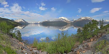
Lyngen (also known as Lyngenfjorden (Norwegian), Ivgovuotna (Northern Sami), or Yykeänvuono (Kven)) is a fjord in Troms county, Norway. The 82-kilometre (51 mi) long fjord is the longest fjord in Troms and it is often used as the dividing line between "northern Troms" and "southern Troms". The fjord is located within the municipalities of Skjervøy, Nordreisa, Lyngen, Gáivuotna–Kåfjord, and Storfjord. It stretches from the village of Hatteng in Storfjord Municipality in the south all the way north to the islands of Skjervøy Municipality. The Lyngen Alps lie along the western shore of the fjord and the European route E06 highway runs along the eastern shore. The Kåfjorden branches off of the main fjord on the east side, and the southernmost part of the fjord is also known as the Storfjorden.[1]
| Lyngen (Norwegian) | |
|---|---|
| |
 View of the fjord | |
 Lyngen Location of the fjord  Lyngen Lyngen (Norway) | |
| Location | Troms county, Norway |
| Coordinates | 69°46′47″N 20°22′58″E / 69.7797°N 20.3827°E |
| Type | Fjord |
| Basin countries | Norway |
| Max. length | 82 kilometres (51 mi) |
| Max. width | 10 kilometres (6.2 mi) |
| Settlements | Lyngseidet, Olderdalen, Skibotn |
Media gallery edit
-
 A view of the Lyngenfjorden
 -
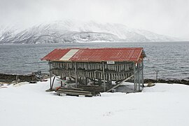 Cod drying along the fjord
 -
 View of the fjord under the northern lights
 -
 View from Rottsund, Nordreisa


See also edit
References edit
- ^ Store norske leksikon. "Lyngen – fjord i Troms" (in Norwegian). Archived from the original on 2013-02-23. Retrieved 2012-12-17.
External links edit
- Visit Lyngenfjord