
KNOWPIA
WELCOME TO KNOWPIA

M2 highway (Russia) 
Summary
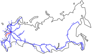
The Russian route M2 (also known as the Crimea Highway, (автодорога "Крым")) is a major trunk road that connects Moscow to Crimea. It is part of the European route E105. It is 720 kilometers long.[1]
 | ||||
|---|---|---|---|---|
| Федеральная автомобильная дорога М2 | ||||
| Crimea Highway | ||||
 | ||||
| Route information | ||||
| Part of | ||||
| Length | 720 km (450 mi) | |||
| Existed | 1950–present | |||
| Major junctions | ||||
| West end | Ukrainian border | |||
| East end | ||||
| Location | ||||
| Country | Russia | |||
| Highway system | ||||
| ||||
Inaugurated in 1950, the highway starts at the junction of the Moscow Ring Road and Varshavskoye Shosse and travels south-west, immediately bypassing the cities of Tula, Oryol, Kursk and Belgorod before terminating at the border with Ukraine.
West of the border at Hoptivka, the road continues through Kharkiv and Zaporizhia to Simferopol and Yalta as the Ukrainian M20 and M18.
See also edit
- Berlinka, the never-completed Reichsautobahn Berlin-Königsberg of the Third Reich into East Prussia.
References edit
- ^ Трасса М2 на карте (Highway M2 map), retrieved 29 January 2024
External links edit
- M2 Highway (from Tula to Moscow), August 2015