


Summary
55°32′27″N 5°18′49″W / 55.540829°N 5.313655°W
 Machrie Moor Stone Circle 2 | |
 Shown within the Isle of Arran, Scotland | |
| Location | Isle of Arran |
|---|---|
| Coordinates | 55°32′27″N 5°18′49″W / 55.540829°N 5.313655°W |
| Type | Stone Circles |
| History | |
| Periods | Neolithic / Early Bronze age |
| Site notes | |
| Ownership | Historic Scotland |
| Public access | Yes |
Machrie Moor Stone Circles is the collective name for six stone circles visible on Machrie Moor near the settlement of Machrie on the Isle of Arran, Scotland.
Description edit
Six stone circles are visible on the moor immediately east of the derelict Moss Farm.[1] Some circles are formed of granite boulders, while others are built of tall red sandstone pillars.[1] The moor is covered with other prehistoric remains, including standing stones, burial cairns and cists.[1] The stone circles are positioned over previous timber circles.[2] A radiocarbon date of 2030 ± 180 BCE has been found for the timber circle at Machrie Moor 1.[3] Several hut circles can also be seen as low rings of turf-covered stone.[1]

The six stone circles are situated below a prominent notch on the skyline to the northeast where Machrie Glen divides into two steep-sided valleys.[4] At the summer solstice the notch is intersected by the sun at sunrise, and this may explain why the circles were sited in this location.[4]
The stone circles were recorded in 1861 by James Bryce, and numbered 1 to 5.[5] Five other monuments in the area were numbered 6 to 10, and when subsequently a further stone circle was discovered almost completely submerged in peat in 1978, it was numbered Machrie Moor 11.[5] Around 1 kilometer to the west is the remains of the Moss Farm Road Stone Circle (Machrie Moor 10).[6][7]
Machrie Moor 1 edit

Machrie Moor 1 (grid reference NR91203239) is an ellipse with axes 12.7 metres and 14.6 metres.[8] It is formed from six granite boulders and five sandstone slabs, arranged alternately.[8] Four of the granite blocks have fallen.[8]
Machrie Moor 2 edit

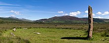
Machrie Moor 2 (grid reference NR91143241) is the most visually striking of the circles on Machrie Moor.[1] This circle has a diameter of 13.7 metres, and may originally have consisted of seven or eight tall sandstone slabs, three of which survive intact, while stumps of others may be seen.[9] The heights of the three intact stones range from 3.7 metres to 4.9 metres.[9] Within the circle are two large stones, apparently cut from a fallen pillar, one of which now has a central hole as if for conversion to a millstone.[9] Excavations in 1861 revealed a cist in the centre of the circle.[9] A food vessel was found in this central cist.[1] A second, empty, short cist was found between the centre and the northeast upright stone.[9]
Machrie Moor 3 edit
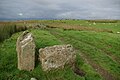
Machrie Moor 3 (grid reference NR91023244) originally consisted of nine stones.[10] Only one still stands, 4.3 metres high, but the stumps of others are still partially visible in the peat.[10] The stones form a geometrical egg-shape.[10] Excavations in 1861 uncovered a small cist in the centre containing an urn with some fragments of burnt bone and flint flakes.[10] A second cist was found 1 metre south of the centre; it contained a crouched burial, also with some flint flakes.[10]
Machrie Moor 4 edit

Machrie Moor 4 (grid reference NR91003235) consists of four granite blocks, about 0.9 metres high.[11] Excavations in 1861 uncovered a cist in the centre.[11] In it was an inhumation accompanied by a food vessel, a bronze awl, and three flint flakes.[11]
Machrie Moor 5 edit
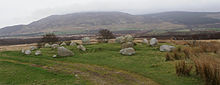
Machrie Moor 5 (grid reference NR90873234) called "Suidh Coire Fhionn" or "Fingal's Cauldron Seat" consists of two concentric rings of granite boulders.[12] The inner circle is 12.0 metres in diameter and consists of eight granite boulders.[12] Excavations in 1861 uncovered an empty, ruined cist in the centre.[12] The outer circle is approximately 18.0 metres in diameter and is formed of fifteen granite boulders.[12] The outer circle is said to form a geometrical egg-shape.[12]
Machrie Moor 11 edit

Machrie Moor 11 (grid reference NR91213242) is a low stone circle with a diameter of around 13 metres.[13] The tallest of the stones is about 1.2 metres high on the western side.[13] Excavations in 1978-9 revealed 10 upright stones, with a pit between each stone possibly representing a post-hole.[13]
Other prehistoric remains edit
James Bryce listed five other antiquities to the west of the stone circles in 1861. Machrie Moor 6 (grid reference NR90733237) is the remains of a possible chambered cairn consisting of two touching upright stone slabs at right angles.[14] Machrie Moor 7 (grid reference NR90633253) is a standing stone 1.6 metres tall.[15] Machrie Moor 8 (grid reference NR90573237) is the remains of a probable chambered cairn comprising an oval spread of stones approximately 20 metres by 16 metres.[16] The most obvious feature is a 1.8 metre tall standing stone within the east edge of the cairn surrounded by several smaller stones which may have been part of a chamber or facade.[16] Machrie Moor 9 (grid reference NR905324) was a standing stone of which no obvious trace remains.[17] Machrie Moor 10 (grid reference NR90053265) is the Moss Farm Road Stone Circle.[18]
-
 Machrie Moor 6
 -
 Machrie Moor 7
 -
 Machrie Moor 8
 -
 Machrie Moor 10


Around 1.2 kilometres to the east of the Machrie Moor Stone Circles, near the B880 road (grid reference NR92443225), is another stone-setting consisting of three granite boulders and which perhaps originally consisted of four stones.[19]
References edit
- ^ a b c d e f Machrie Moor Stone Circles, Historic Scotland, accessed 1 May 2014
- ^ Richards, Colin (2013). Building the Great Stone Circles of the North. Windgather Press. pp. 50–. ISBN 978-1-909686-15-1.
- ^ Burl, Aubrey (2005). A Guide to the Stone Circles of Britain, Ireland and Brittany. Yale University Press. p. 35. ISBN 0300114060.
- ^ a b Burl, Aubrey (2005). A Guide to the Stone Circles of Britain, Ireland and Brittany. Yale University Press. p. 118. ISBN 0300114060.
- ^ a b "Machrie Moor" in Current Archaeology (1988), page 35
- ^ Moss Farm Road Stone Circle, Historic Scotland, accessed 1 May 2014
- ^ Burl, Aubrey (2005). A Guide to the Stone Circles of Britain, Ireland and Brittany. Yale University Press. p. 114. ISBN 0300114060.
- ^ a b c Historic Environment Scotland. "Machrie Moor 1 (39703)". Canmore. Retrieved 1 May 2014.
- ^ a b c d e Historic Environment Scotland. "Machrie Moor 2 (39702)". Canmore. Retrieved 1 May 2014.
- ^ a b c d e Historic Environment Scotland. "Machrie Moor 3 (39700)". Canmore. Retrieved 1 May 2014.
- ^ a b c Historic Environment Scotland. "Machrie Moor 4 (39701)". Canmore. Retrieved 1 May 2014.
- ^ a b c d e Historic Environment Scotland. "Machrie Moor 5 (39705)". Canmore. Retrieved 1 May 2014.
- ^ a b c Historic Environment Scotland. "Machrie Moor 11 (39704)". Canmore. Retrieved 1 May 2014.
- ^ Historic Environment Scotland. "Machrie Moor 6 (39706)". Canmore. Retrieved 20 May 2014.
- ^ Historic Environment Scotland. "Machrie Moor 7 (39715)". Canmore. Retrieved 20 May 2014.
- ^ a b Historic Environment Scotland. "Machrie Moor 8 (39707)". Canmore. Retrieved 20 May 2014.
- ^ Historic Environment Scotland. "Machrie Moor 9 (39770)". Canmore. Retrieved 20 May 2014.
- ^ Historic Environment Scotland. "Machrie Moor 10 (39726)". Canmore. Retrieved 20 May 2014.
- ^ Historic Environment Scotland. "Ballymichael, Arran Bridge Farm, Stone Setting (39711)". Canmore. Retrieved 20 May 2014.
External links edit
- Highlands walks