
-
 The Dorf, Macugnaga, Italy
 -
 Traditional Walser hut located in the Dorf, Macugnaga, Italy
 -
 Stone bakery oven located in the Dorf, Macugnaga, Italy

KNOWPIA
WELCOME TO KNOWPIA
Macugnaga 
Summary
Macugnaga (Walser German: Z'Makana) is a mountain village and a comune at 1,327 metres (4,354 ft) elevation, in the province of Verbano-Cusio-Ossola, in the north of the Piedmont region of Italy.
Macugnaga | |
|---|---|
| Comune di Macugnaga | |
 | |
Location of Macugnaga .mw-parser-output .locmap .od{position:absolute}.mw-parser-output .locmap .id{position:absolute;line-height:0}.mw-parser-output .locmap .l0{font-size:0;position:absolute}.mw-parser-output .locmap .pv{line-height:110%;position:absolute;text-align:center}.mw-parser-output .locmap .pl{line-height:110%;position:absolute;top:-0.75em;text-align:right}.mw-parser-output .locmap .pr{line-height:110%;position:absolute;top:-0.75em;text-align:left}.mw-parser-output .locmap .pv>div{display:inline;padding:1px}.mw-parser-output .locmap .pl>div{display:inline;padding:1px;float:right}.mw-parser-output .locmap .pr>div{display:inline;padding:1px;float:left}html.skin-theme-clientpref-night .mw-parser-output .od,html.skin-theme-clientpref-night .mw-parser-output .od .pv>div,html.skin-theme-clientpref-night .mw-parser-output .od .pl>div,html.skin-theme-clientpref-night .mw-parser-output .od .pr>div{background:#000;color:#fff}html.skin-theme-clientpref-night .mw-parser-output .locmap{filter:grayscale(0.6)}@media(prefers-color-scheme:dark){html.skin-theme-clientpref-os .mw-parser-output .locmap{filter:grayscale(0.6)}html.skin-theme-clientpref-os .mw-parser-output .od,html.skin-theme-clientpref-os .mw-parser-output .od .pv>div,html.skin-theme-clientpref-os .mw-parser-output .od .pl>div,html.skin-theme-clientpref-os .mw-parser-output .od .pr>div{background:#000;color:#fff}}  Macugnaga Location of Macugnaga in Italy  Macugnaga Macugnaga (Piedmont) | |
| Coordinates: 45°58′N 7°58′E / 45.967°N 7.967°E | |
| Country | Italy |
| Region | Piedmont |
| Province | Verbano-Cusio-Ossola (VB) |
| Frazioni | Borca, Pestarena, Fornarelli, Isella, Motta, Stabioli, Staffa (municipal seat) |
| Government | |
| • Mayor | Alessandro Bonacci |
| Area | |
| • Total | 99.57 km2 (38.44 sq mi) |
| Elevation | 1,327 m (4,354 ft) |
| Population (1 January 2021)[2] | |
| • Total | 532 |
| • Density | 5.3/km2 (14/sq mi) |
| Demonym | Macugnaghese(i) |
| Time zone | UTC+1 (CET) |
| • Summer (DST) | UTC+2 (CEST) |
| Postal code | 28876 |
| Dialing code | 0324 |
| Patron saint | Assumption of Mary |
| Saint day | 15 August |
| Website | Official website |

It is located at the base of Monte Rosa (4,638 metres (15,217 ft)), the second-tallest mountain in western Europe, along Valle Anzasca, one of the seven valleys around the mount.
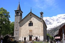
Sights in the town include the Chiesa Vecchia (old church) and its linden also of the 13th century, the Chiesa Nuova (new church) built in 1707, the 17th century Casa Pala. The town also houses a museum of mountaineering, while in the hamlet of Borca is the Walser Museum, devoted to the local German population who colonised the valley during the Middle Ages coming from the Swiss canton Wallis.
The area gives many opportunities for skiing in winter (a cableway brings from the central square of the town to the 3000 m (9800 ft) of the Passo del Monte Moro on the border with Switzerland), and hiking and mountaineering in summer. There are a swimming pool, a tennis centre, and a football field for sport activities.
The village is also known for its mine (Miniera della Guia).
Geography edit
The territory is characterised by numerous rivers, some of which are Horlovono, Pedriola, Tambach, Testa / Tieschtbach, Quarazza / Kratz and Val Rossa, all of them coming from Anza / Vispu. This last one is born from the union between the Belvedere Glacier. A lot of small lakes can be found around the village, as well as a dam, known as Lago delle Fate (lake of the fairies).
Dorf edit
The Dorf is an area of the village of Macugnaga, located near the Old Church and its cemetery, where the ancient huts made of larch trunks, in which the Walser community used to live, are located.[3]
The houses followed the style of the Nordic populations: they were made of larch wood to protect its inhabitants from the cold weather. They were equipped with a stove together with an oven, there was also a kitchen, two bedrooms and a cellar. In the most recent structures, the kitchen was built in brickwork to prevent the risk of fires. Other buildings, apart from the houses, can include farmhouses with a stable and a barn.[4]
In the Dorf, there is also a traditional stone bakery oven which was used by the Walser people once a year to bake bread. It was an important moment for the community to ensure food supplies in the following months. [5]


Twin cities edit
References edit
- ^ "Superficie di Comuni Province e Regioni italiane al 9 ottobre 2011". Italian National Institute of Statistics. Retrieved 16 March 2019.
- ^ All demographics and other statistics from the Italian statistical institute (Istat)
- ^ Guide De Agostini (1988). Scoprire l'Ossola e le sue valli [Discover Ossola and its valleys]. Istituto Geografico De Agostini. ISBN 9788840201559.
- ^ Rossi, D. Luigi (1928). Valle Anzasca e Monte Rosa [Anzasca Valley and Monte Rosa]. Domodossola: Tipografia Commerciale Nicola Zonca. p. 235.
- ^ Cresta, Renato (1984). Macugnaga tra storia e leggenda [Macugnaga between history and legend]. Turin: S.A.C.A.T. p. 22.
External links edit
- Official website
- Useful information and photos
- Information, forum and photos