


Summary
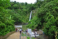
Madhabkunda Waterfall (Bengali: মাধবকুন্ড জলপ্রপাত) is one of the highest waterfalls in Bangladesh. Situated in Barlekha Upazila of Moulvibazar District, the waterfall is a popular tourist spot in Bangladesh.[1] The forest, streams, and ecological park in the vicinity attract numerous tourists for picnics and day trips.
| Madhabkunda Waterfall | |
|---|---|
| মাধবকুণ্ড জলপ্রপাত | |
 | |
 | |
| Location | Barlekha Upazila, Moulvibazar District |
| Coordinates | 24°38′18.5″N 92°13′28.4″E / 24.638472°N 92.224556°E |
| Type | Plunge waterfall |
| Total height | 162 feet (49 m) |
| Watercourse | Gangamara stream |
The area holds significance for Hindus, with a nearby temple where Hindu rituals are performed annually, accompanied by a fair. Adjacent to the pool on the right side lies a cave, revered as a pilgrimage site.[2]
Geology edit
The Gangamara stream cascades 162 feet (49 m) feet down from the rocky Patharia Hill, forming the Madhabkunda Waterfall, which then transitions into the Madhabchhara stream below. The waters of Madhabchhara flow westward and eventually converge into the Hakaluki Haor.[2]
The main stream typically maintains a steady flow throughout the year. During the monsoon season, a smaller stream forms adjacent to the main one, and as the monsoon intensifies, the two streams converge, combining into a powerful current. This robust flow cascades downward, forming a substantial pool below. The pool's depth increases continuously as water continues to fall into it.[2]
Toponymy edit
Two popular legends surround the origin of the name Madhabkunda. According to one, Raja Govardhan of Gour, the last Hindu king of Sylhet, encountered a meditating monk named Madhaveshwar while on a hunting expedition in 1335 AD. The monk expressed a desire to unite with the goddess Ganga and requested immersion in the spring. Following the monk's request, he merged with Ganga, and a divine voice uttered "Madhav Madhav Madhav" three times, giving rise to the name Madhabkunda. Another legend suggests the name originates from "Madhav," one of Shiva's names, as it is believed Shiva appeared at this location.[3]
Environment edit
A tourist site called Madhabkunda Eco Park has been established in proximity to the waterfall with an area of about 500 acres (2.0 km2), attracting numerous tourists each year.[4] Surrounding the waterfall is a vast forest area inhabited by the indigenous Khasi tribe. Another nearby attraction is the Parikunda waterfall.[2]
Transport edit
The waterfall is located at 24°38′18.5″N 92°13′28.4″E / 24.638472°N 92.224556°E. It is about five km away from Dakshinbagh Railway Station.[1] Visitors can visit Madhabkunda either from Sylhet or Moulvibazar by road, or from Kulaura Junction by train.[5]
Gallery edit
-
 View of Madhabkunda
 -
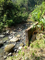 Stream near Madhabkunda Waterfall
 -
 Tribal village and stream near Madhabkunda
 -
 Stairs leading to the waterfall
 -
 Tribal village near Madhabkunda Waterfall


See also edit
References edit
- ^ a b Chowdhury, Sifatul Quader (2012). "Waterfall". In Sirajul Islam; Miah, Sajahan; Khanam, Mahfuza; Ahmed, Sabbir (eds.). Banglapedia: the National Encyclopedia of Bangladesh (Online ed.). Dhaka, Bangladesh: Banglapedia Trust, Asiatic Society of Bangladesh. ISBN 984-32-0576-6. OCLC 52727562. OL 30677644M. Retrieved 16 April 2024.
- ^ a b c d "মাধবকুণ্ড জলপ্রপাত" [Madhabkunda Waterfall]. Kaler Kantho (in Bengali). 5 April 2023. Retrieved 4 April 2024.
- ^ Husayn, Matubbar Tufahel (22 July 2019). মাধবকুণ্ডের কথা (in Bengali). SylhetView24.
- ^ Md Mojaharul Islam (2012). "Ecopark". In Sirajul Islam; Miah, Sajahan; Khanam, Mahfuza; Ahmed, Sabbir (eds.). Banglapedia: the National Encyclopedia of Bangladesh (Online ed.). Dhaka, Bangladesh: Banglapedia Trust, Asiatic Society of Bangladesh. ISBN 984-32-0576-6. OCLC 52727562. OL 30677644M. Retrieved 16 April 2024.
- ^ "Places to visit outside Dhaka". Archived from the original on 2 November 2011. Retrieved 5 October 2011. Dhaka City Portal