


Summary
Magalang, officially the Municipality of Magalang (Kapampangan: Balen ning Magalang; Tagalog: Bayan ng Magalang), is a 1st class municipality in the province of Pampanga, Philippines. According to the 2020 census, it has a population of 124,188 people.[3]
Magalang | |
|---|---|
| Municipality of Magalang | |
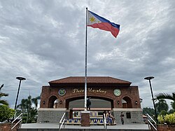 Plaza de Magalang, also known as Plaza de la Libertad | |
 Flag  Seal | |
| Nickname: Sweet Tamarind Capital of The Philippines | |
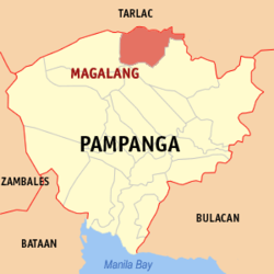 Map of Pampanga with Magalang highlighted | |
OpenStreetMap .mw-parser-output .locmap .od{position:absolute}.mw-parser-output .locmap .id{position:absolute;line-height:0}.mw-parser-output .locmap .l0{font-size:0;position:absolute}.mw-parser-output .locmap .pv{line-height:110%;position:absolute;text-align:center}.mw-parser-output .locmap .pl{line-height:110%;position:absolute;top:-0.75em;text-align:right}.mw-parser-output .locmap .pr{line-height:110%;position:absolute;top:-0.75em;text-align:left}.mw-parser-output .locmap .pv>div{display:inline;padding:1px}.mw-parser-output .locmap .pl>div{display:inline;padding:1px;float:right}.mw-parser-output .locmap .pr>div{display:inline;padding:1px;float:left}html.skin-theme-clientpref-night .mw-parser-output .od,html.skin-theme-clientpref-night .mw-parser-output .od .pv>div,html.skin-theme-clientpref-night .mw-parser-output .od .pl>div,html.skin-theme-clientpref-night .mw-parser-output .od .pr>div{background:#000;color:#fff}html.skin-theme-clientpref-night .mw-parser-output .locmap{filter:grayscale(0.6)}@media(prefers-color-scheme:dark){html.skin-theme-clientpref-os .mw-parser-output .locmap{filter:grayscale(0.6)}html.skin-theme-clientpref-os .mw-parser-output .od,html.skin-theme-clientpref-os .mw-parser-output .od .pv>div,html.skin-theme-clientpref-os .mw-parser-output .od .pl>div,html.skin-theme-clientpref-os .mw-parser-output .od .pr>div{background:#000;color:#fff}}  Magalang Location within the Philippines | |
| Coordinates: 15°13′N 120°40′E / 15.22°N 120.67°E | |
| Country | Philippines |
| Region | Central Luzon |
| Province | Pampanga |
| District | 1st district |
| Founded | April 30, 1605 |
| Barangays | 27 (see Barangays) |
| Government | |
| • Type | Sangguniang Bayan |
| • Mayor | Maria Lourdes P. Lacson |
| • Vice Mayor | Joseph G. Guzman |
| • Representative | Carmelo B. Lazatin II |
| • Councilors | List
|
| • Electorate | 78,392 voters (2022) |
| Area | |
| • Total | 97.32 km2 (37.58 sq mi) |
| Elevation | 48 m (157 ft) |
| Highest elevation | 147 m (482 ft) |
| Lowest elevation | 22 m (72 ft) |
| Population (2020 census)[3] | |
| • Total | 124,188 |
| • Density | 1,300/km2 (3,300/sq mi) |
| • Households | 28,072 |
| Economy | |
| • Income class | 1st municipal income class |
| • Poverty incidence | 4.96 |
| • Revenue | ₱ |
| • Assets | ₱ |
| • Expenditure | ₱ |
| • Liabilities | ₱ |
| Service provider | |
| • Electricity | Pampanga 1 Electric Cooperative (PELCO 1) |
| Time zone | UTC+8 (PST) |
| ZIP code | 2011 |
| PSGC | 035411000 |
| IDD : area code | +63 (0)45 |
| Native languages | Kapampangan Tagalog |
| Catholic diocese | Archdiocese of San Fernando |
History edit
Magalang was mentioned as a visita to the nearby town of Arayat on December 29, 1598. On April 30, 1605, it was separated by the Augustinians from Arayat and attained township status due to the bajo de la campana system. The Augustinians appointed Fr. Gonzalo de Salazar, OSA as the first pastor.
Magalang was initially called Magalo, derived from the Kapampangan word "Galo", which means wavy and moving, describing the dangerous flow of the Parua River.
The town proper was located in Macapsa, but due to the natural calamities and revolts led by Andres Malong and his subordinate Melchor de Vera against the Spanish in 1660, it was nearly abandoned. It was moved to San Bartolome in 1734 until it was swept by the flood due to the overflow of the Parua River in 1863. It was transferred to the present site in barrio San Pedro Talimunduc on December 13, 1863, led by the parish priest, Fr. Ignacio Manzanares, OSA and some of the members of principalia including Pablo M. Luciano, gobernadorcillo of Magalang at that time.
In 1885, the agricultural experiment station La Granja Modelo de Luzon was transferred from San Isidro, Nueva Ecija to the foothills of Mount Arayat, which became the present Pampanga State Agricultural University.
The revolutionary government took over the local government on June 12, 1898, led by General Francisco Macabulos and Colonel Lorenzo D. Camaya. During that time, Magalang was one of the revolutionary centers in Pampanga due to its proximity to Camansi, a revolutionary headquarters located in Mount Arayat. The forces of Major General Servillano Aquino defended Magalang against the Americans until it was successfully captured on November 5, 1899, led by Major General Arthur MacArthur and Colonel Jacob H. Smith.
During the Second World War, Japanese forces defeated the Filipino-American forces composed of Igorot troops led by Major Helmert Duisterhof and Capt. Russell W. Volckmann, paving the way for the capture of Magalang on January 1, 1942. It was liberated by the 148th Infantry of 37th Division, US Army with the help of Hukbalahap on January 25, 1945. It was one of the hotbeds of the Hukbalahap insurgency until the rebellion was crushed in 1954.
On December 28, 1963, Mayor Benedicto T. Dayrit was assassinated by the alleged men of Commander Sumulong during a night ball in the town plaza. In 1968, Mayor Daniel T. Lacson was sworn in as mayor of Magalang until his term ended in 1986.
In December 1993, Mayor Daniel Lacson Jr. was briefly replaced by his political rival Elpidio Lakandula when the latter was declared the victor in the 1992 election by the Angeles City Regional Trial Court on December 28, which was immediately met with protests by Lacson and his followers.[5]
During the tenure of Mayor Pastor Z. Guiao, Magalang was named one of the cleanest municipalities in the Philippines. Mayor Maria Lourdes P. Lacson was sworn in on June 30, 2016, as the first woman mayor of Magalang.[6]
The National Museum of the Philippines declared on December 23, 2015, the "Magalang Municipal Hall" as an Important Cultural Property (Philippines).[7]
Heliograph Towers edit
On August 21, 2017, the “Heliograph Towers” inside the premises of Cariyana Monastery in Barangays San Isidro and Santa Cruz were declared as Important Cultural Property (Philippines) of the National Museum of the Philippines per Resolution 14-2016. They were officially turned over by the National Museum of the Philippines to the local government unit on May 27, 2021. The "Torre" was called "imburnal", “bornal” or “batiawan” as smoke outlets for “cabiawan” or trapiche of early carabao-driven sugar mills. These solar-sun telegraphs are made of fine laryu (red bricks) and huge cut stones of pumiceous rocks and volcanic tuff. They were used as “sun writers” (mirrored communications devices for sending messages in Morse code by flashing the reflected sun's rays to a distant station).
The 1896 description states: “An instrument called the heliograph, or sun telegraph, constructed with small mirrors made to turn upon both a horizontal and vertical axis, mounted upon a tripod, so arranged as to make the flashes appear and disappear in rapid succession, is to a limited extent in use in the army; and by it, messages may be transmitted much faster than with flags or torches, and it can be used at longer ranges. It is manipulated by a key similar to the electric telegraph instrument. Mirror signaling was first used by the North American Indians.”[8]
Erected by General Don Ricardo Monet y Carretero, a Commandant of War in 1863, the Towers were used by the Spanish army as stations of communication for faster transmission of messages and signals and to destroy the revolutionary forces in Camansi in Mount Arayat led by General Francisco Macabulos. In a letter dated May 8, 1898, Monet informed the Comandancia General del Centro de Luzon of the destruction of activities of the detachment of Camansi located at Mount Arayat, transforming it into a blok-haus constructed at Magalang with some torre heliografico located in the 10 towns of Magalang and Concepcion, Tarlac with a height of 20 meters and made under the charge of the Engineering Corps. Originally, three "batiauan" or watchtowers were built but only two existed (Santa Cruz and San Isidro) and were also used to watch the coming of the enemies. Later the towers once produced muscovado sugar and panotsa.[9][10]
Geography edit
Barangays edit
Magalang is politically subdivided into 27 barangays. Each barangay consists of puroks and some have sitios.
- Ayala
- Bucanan
- Camias
- Dolores
- Escaler
- La Paz
- Navaling
- San Agustin
- San Antonio
- San Francisco
- San Ildefonso
- San Isidro
- San Jose
- San Miguel
- San Nicolas I
- San Nicolas II (Concepcion)
- San Pablo
- San Pedro I
- San Pedro II
- San Roque
- San Vicente
- Santa Cruz
- Santa Lucia
- Santa Maria
- Santo Nino
- Santo Rosario
- Turu
Climate edit
| Climate data for Magalang, Pampanga | |||||||||||||
|---|---|---|---|---|---|---|---|---|---|---|---|---|---|
| Month | Jan | Feb | Mar | Apr | May | Jun | Jul | Aug | Sep | Oct | Nov | Dec | Year |
| Mean daily maximum °C (°F) | 30 (86) |
31 (88) |
32 (90) |
34 (93) |
33 (91) |
31 (88) |
31 (88) |
29 (84) |
29 (84) |
30 (86) |
30 (86) |
29 (84) |
31 (87) |
| Mean daily minimum °C (°F) | 19 (66) |
19 (66) |
20 (68) |
22 (72) |
24 (75) |
24 (75) |
24 (75) |
24 (75) |
24 (75) |
22 (72) |
21 (70) |
20 (68) |
22 (71) |
| Average precipitation mm (inches) | 5 (0.2) |
5 (0.2) |
10 (0.4) |
23 (0.9) |
136 (5.4) |
191 (7.5) |
245 (9.6) |
241 (9.5) |
200 (7.9) |
108 (4.3) |
36 (1.4) |
12 (0.5) |
1,212 (47.8) |
| Average rainy days | 2.6 | 2.5 | 4.4 | 8.3 | 20.9 | 24.4 | 27.4 | 26.9 | 25.0 | 18.2 | 9.2 | 3.6 | 173.4 |
| Source: Meteoblue[11] | |||||||||||||
Demographics edit
|
| |||||||||||||||||||||||||||||||||||||||||||||||||||
| Source: Philippine Statistics Authority[3][12][13][14][15] | ||||||||||||||||||||||||||||||||||||||||||||||||||||
In the 2020 census, the population of Magalang, Pampanga, was 124,188 people,[3] with a density of 1,300 inhabitants per square kilometre or 3,400 inhabitants per square mile.
Religion edit


Roman Catholics account for 85% of the population; Magalang also hosts churches of Members Church of God International or Ang Dating Daan. Other major religious groups are Iglesia ni Cristo which has the adherence of 3% of the population, Evangelical Christians and others.
Aside from Catholic churches, the town has a United Methodist Church. In 1908, Protestantism was introduced and Vicente Naguit was the first convert.
San Bartolome Parish Church edit
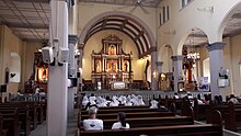
St. Bartholomew Parish Church (Roman Catholic Archdiocese of San Fernando, Vicariate of St. John the Beloved) was established by the Augustinians on April 30, 1605. The present edifice was constructed in 1866 by Fr. Ramon Sarrionandia, OSA. The 3-aisle church is made of stone and wood. It is 55m. long, 21m. wide and 7m. high. Interplay of arches, as seen on the main entrance, doors and niches, pediments and fenestrations, including those of the belltowers and adjacent convent suggest a touch of baroque.[16][17][18]
San Agustin Chapel edit
This chapel located in Dapa, San Agustin, Magalang; where the miraculous image of San Agustin is enshrined. During Spanish period, the image was believed to be carved out by a bandit nearby Mt. Arayat. The small image of San Agustin was brought to Dapa, and there, the small image gradually become larger and miraculous. The image itself cured many diseases and granting child, for those couples who are childless. The chapel is open during Fridays and Holy Week.[19]
San Padre Pio Pietrelcina Chapel edit
This chapel is located in sitio Mabato-Bato in San Francisco, Magalang. A first class relic composed of hair particles of St. Padre Pio Pietrelcina was enshrined in this chapel last 2017. Devotees of Padre Pio came to this chapel to paid visit, seek his intercession to their different personal intentions. The chapel is open during Thursdays, 8:00am to 7:00pm. A holy mass is to be offer during third Thursday of the month; and the veneration of the relic is followed after the mass.[20]
Lord's Epiphany Parish edit
This parish church located in Angeles-Magalang Road, San Francisco, Magalang was established in 1996. A first class relic of St. Francis of Assisi composed of a piece of bone and his staff, was enshrined in the church last 2016. The veneration of the relic is open during Tuesdays. A holy mass is to be offer in that same day in 6:00pm. After the holy mass, the veneration of the relic and anointing of St. Francis' oil is held after the mass.[21]
Sta Clara de Assisi Chapel edit
This chapel is located in sitio Tambacan in San Francisco, Magalang. The chapel, where the second class relic of Saint Claire of Assisi is enshrined. The relic is composed of small piece of veil used by the saint. The chapel is open during Thursdays.[22]
Banal a Bunduk, Dalan ning Krus edit
This iconic site was born due to the efforts of Soroptimist International of Magalang. The site is located in sitio Orchard, barrio Ayala, Magalang; in the rolling foothills of Mt. Arayat. This site is composed of life sized images of 14 stations of the cross of Christ. It is favorite destination of pilgrims and devotees during Holy Week.
Economy edit
Fishpond owners in Pampanga source their fingerlings (tilapia) from producers in this town, it's well known for its confectionaries (sweets) particularly the incomparable pastilla de leche, a popular item for gift-giving and a table dessert on fiestas and social gatherings. The Magalang sweets are distinct in their unique taste because of the quality of the milk from water buffalo (carabao) that feed on green grass growing on the fresh well-irrigated pastureland of the agricultural section of the town. And large amount of land is Corn or Rice Grain.[30]
Government edit
Magalang is part of the 1st Congressional District of Pampanga.
Local government edit
Like other towns in the Philippines, Magalang is governed by a mayor and vice mayor who are elected to three-year terms. The mayor is the executive head and leads the town's departments in executing the Sangguniang Bayan's ordinances and improving public services. The vice mayor heads a legislative council consisting of councilors, as members.
List of local chief executives edit
- Gobernardorcillos
- Pablo M. Luciano (1863)
- Pablo Pineda (1864)
- Jose Calalang (1865)
- Emigdio Mendoza (1866)
- Santiago C. Suing (1867)
- Manuel S. Lacson (1868)
- Valentin L. Dayrit (1869-1871)
- Anacleto S. Lacson (1871-1873)
- Luis M. Magdangal (1873-1875)
- Tereso C. Manalo (1875-1877)
- Apolonio Lising (1877-1879)
- Abdon Supan (1879-1881)
- Pablo M. Luciano (1881-1882)
- Teopisto S. Ganzon (1882)
- Domingo E. David (1882-1883)
- Raymundo Sanchez (1883-1885)
- Santiago Angeles (1885-1887)
- Tomas R. Dizon (1887-1888)
- Domingo P. Tayag (1888)
- Paulino C. Gueco (1888-1889)
- Domingo H. Gantioqui (1889-1891)
- Aniceto S. Lacson (1891-1893)
- Capitan Municipales (Regimen Maura)
- Manuel C. Gueco (1893-1895)
- Teopisto S. Ganzon (1895-1896)
- Paulino C. Gueco (1896-1898)
- Revolucion
- Buenaventura C. Paras (1898)
- Ladislao C. Dayrit (1898-1899)
- American Regime (Alcalde)
- Daniel O. Lacson (1899-1901)
- Municipal Presidents
- Juan P. Feliciano (1901-1902)
- Tomas R. Dizon (1902-1903)
- Regino P. Gamboa (1903-1904)
- Manuel C. Gueco (1904-1905)
- Jose F. Luciano (1905-1907)
- Juan P. Feliciano (1907-1909)
- Dr. Andres J. Luciano (1909-1912)
- Irineo F. Dizon (1912-1913)
- Alfredo G. Ganzon (1913-1916)
- Pablo A. Luciano (1917-1923)
- Antonio Y. Luciano (1923-1925)
- Juan P. Feliciano (1925-1928)
- Atanacio M. Baluyut (1928-1931)
- Atty. Jose C. Morales (1931-1934)
- Alcalde (Commonwealth Period)
- Dr. Servillano D. Ayuyao (1934-1937)
- Jose M. Navarro (1937-1940)
- Alcalde (Japanese Government)
- Jose M. Navarro (1940-1943)
- Atty. Isidoro D. Ayuyao (1943-1945)
- Alcalde (Liberation)
- Antonio P. Tiglao (1945-1947)
- Mayors (Republic of the Philippines)
- Dr. Ricardo Tapnio (1947-1951)
- Enrique P. Baluyut (1952-1955)
- Orencio A. Gueco (1956-1959)
- Benedicto T. Dayrit (1960-1963)
- Rogelio O. Tiglao (1964-1965)
- Dr. Gregorio S. Liwanag (1966-1967)
- Daniel T. Lacson, Sr. (1968-1986)
- Pablo David (1986-1987)
- Daniel L. Lacson, Jr. (1988-1998)
- Lamberto M. Cruz (acting) (1998)
- Pastor Z. Guiao (1998-2007)
- Lyndon A. Cunanan (2007-2009)
- Romulo F. Pecson (2009-2016)
- Maria Lourdes P. Lacson (2016-2019)
- Romulo F. Pecson (2019-2022)
- Maria Lourdes P. Lacson (2022-)
Infrastructure edit
Roads edit
During the visit of the governor in the remote barangay of Turu in Magalang, she announced the concrete pavement of the one kilometer farm to market road in the said village amounting to P6-million.[32]
- Magalang – Angeles Road – connecting between Angeles City to Magalang
- Magalang - Mabalacat Road. – connecting between Magalang to Mabalacat
- Magalang – Arayat – Santa Ana Road – connecting between Magalang to Santa Ana, bypassing Arayat
- Magalang – Concepcion Provincial Road (Ninoy Aquino Highway) – provincial road from Magalang, Pampanga to Concepcion, Tarlac
- Don Luis Dizon Drive (also known As PAC Rd.) –connecting Magalang Poblacion - AMLHS and PAC
Health care edit
On January 10, 2012, Governor Lilia Pineda led the inauguration of the P35-million Andres Luciano District Hospital (ALDH) in Barangay San Pablo.[33]
Education edit

Colleges and universities edit
- Pampanga State Agricultural University (PSAU), San Agustin
- Far East College of Information and Technology, San Francisco
Secondary schools edit
- Andres M. Luciano High School (formerly Magalang National High School and Balitucan High School Annex), San Pablo

- Dolores National High School, Dolores
- Ayala High School, Ayala
- Balitucan National High School, Balitucan, San Ildefonso
- Rodolfo V. Feliciano Memorial High School, San Pedro 2
- Tinajero National High School - Annex, Sta. Lucia
Elementary schools edit
- Magalang Elementary School (Magalang Central School), San Nicolas 1
- Bucanan Elementary School, Bucanan
- San Agustin Elementary School, San Agustin
- San Miguel Elementary School, San Miguel
- San Francisco Elementary School, San Francisco
- San Pedro 2 Elementary School, San Pedro 2
- San Pablo Elementary, San Pablo
- Navaling Elementary School, Navaling
- Santa Cruz Elementary School, Santa Cruz
- Santa Maria Elementary School, Santa Maria
- San Vicente Elementary School, San Vicente
- Turu Elementary School, Turu
- Balitucan Elementary School, San Ildefonso
- Escaler Elementary School, Escaler
- Santo Nino Elementary School, Santo Nino
- Santo Rosario Elementary School, SantoRosario, Magalang, Pampanga
- Cabalantian Elementary School, Santa Lucia
- San Roque Elementary School (SRES) - San Roque (Paligi)
Private schools edit
- Christian Vision Academy Foundation (Pampanga), Inc., Sta Lucia
- Christian Vision Academy San Isidro Annex, San Isidro
- Hillcrest Heights Institute, San Francisco
- Magalang Christian Ecumenical School, Santa Cruz
- St. Nathanael Academy, San Nicolas 1
- Magalang Institute, San Nicolas 2
- AYZ Little Saint's School, San Pedro 2
- St. Bernice School, Sta Cruz
- Golden Vine Center for Childcare and Development, San Nicolas 1
- True Light Foundation School, San Pablo
- Brighter Years Child Development Center Inc., Santa Cruz
- Magalang Christian Ecumenical School, Inc.
- Great Shepherd School of Magalang, Inc.
Festivals and Events edit
| Date | Name |
|---|---|
| April 30 | Magalang Foundation Day |
| August 24 | Magalang Town Fiesta (Camaru Festival) |
| August 28 | Feast of San Agustin |
| December 12 | Banal a Batuin or Lubenas |
| December 13 | Transfer Day |
Notable personalities edit
- Juan Severino Mallari, first Filipino serial killer who killed at least 57 people when he was the town's parish priest from 1816 to 1826.[34]
- Liza Lorena, actress
- Tonton Gutierrez, actor
- Mariel Rodriguez, actor
- Yeng Guiao, athlete and politician
- Vivencio Cuyugan, co-founder of the Hukbalahap
- Ed Ocampo, athlete
- Oscar V. Cruz, Roman Catholic prelate
- Norman Gonzales, athlete
Images edit
-
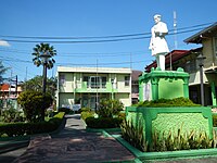
 Town hall
 -
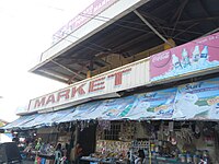 Public market
 -
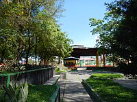
 Plaza of Rizal
 -
 The covered court
 -
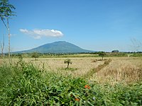 View of Mount Arayat from Magalang, Pampanga highway
 -
 The Heliograph Tower


References edit
- ^ Municipality of Magalang | (DILG)
- ^ "2015 Census of Population, Report No. 3 – Population, Land Area, and Population Density" (PDF). Philippine Statistics Authority. Quezon City, Philippines. August 2016. ISSN 0117-1453. Archived (PDF) from the original on May 25, 2021. Retrieved July 16, 2021.
- ^ a b c d Census of Population (2020). "Region III (Central Luzon)". Total Population by Province, City, Municipality and Barangay. Philippine Statistics Authority. Retrieved 8 July 2021.
- ^ "PSA Releases the 2018 Municipal and City Level Poverty Estimates". Philippine Statistics Authority. 15 December 2021. Retrieved 22 January 2022.
- ^ Burgos, Roberto (January 13, 1994). "More cops deployed to avert violence". Manila Standard. Kamahalan Publishing Corp. p. 4. Retrieved December 26, 2021.
Lakandula immediately took over the municipal hall, prompting Mayor Lacson and his supporters to stage protest actions that threatened peace and order in the town.
- ^ Bartolo, Louie Aldrin and Dizon, Lino.(2016) The Magalang Book: The Historical Life and Culture of a Kapampangan Town (1605-2015). National Commission for Culture and the Arts.
- ^ Villa, Alexandra (December 25, 2015). "National Museum bares 2015 list of cultural treasures, properties". Philippine Daily Inquirer.
- ^ Pavia, Joey (March 5, 2017). "Pampanga town promotes historical structures". BusinessMirror.
- ^ Cayabyab, Charlene (May 31, 2021). "Magalang's commitment to cultural preservation". SunStar.
- ^ "Magalang Heliograph Towers declared 'cultural properties'". SunStar. August 22, 2017.
- ^ "Magalang: Average Temperatures and Rainfall". Meteoblue. Retrieved May 5, 2020.
- ^ Census of Population (2015). "Region III (Central Luzon)". Total Population by Province, City, Municipality and Barangay. Philippine Statistics Authority. Retrieved 20 June 2016.
- ^ Census of Population and Housing (2010). "Region III (Central Luzon)" (PDF). Total Population by Province, City, Municipality and Barangay. National Statistics Office. Retrieved 29 June 2016.
- ^ Censuses of Population (1903–2007). "Region III (Central Luzon)". Table 1. Population Enumerated in Various Censuses by Province/Highly Urbanized City: 1903 to 2007. National Statistics Office.
{{cite encyclopedia}}: CS1 maint: numeric names: authors list (link) - ^ "Province of Pampanga". Municipality Population Data. Local Water Utilities Administration Research Division. Retrieved 17 December 2016.
- ^ Historical / Public - Magalang Historical and Cultural Heritage
- ^ [eK!] magalang, pampanga, philippines: profile & brief history
- ^ history
- ^ Amlat Magaleno
- ^ Amlat Magaleno
- ^ Amlat Magaleno
- ^ Amlat Magaleno
- ^ "Poverty incidence (PI):". Philippine Statistics Authority. Retrieved December 28, 2020.
- ^ "Estimation of Local Poverty in the Philippines" (PDF). Philippine Statistics Authority. 29 November 2005.
- ^ "2003 City and Municipal Level Poverty Estimates" (PDF). Philippine Statistics Authority. 23 March 2009.
- ^ "City and Municipal Level Poverty Estimates; 2006 and 2009" (PDF). Philippine Statistics Authority. 3 August 2012.
- ^ "2012 Municipal and City Level Poverty Estimates" (PDF). Philippine Statistics Authority. 31 May 2016.
- ^ "Municipal and City Level Small Area Poverty Estimates; 2009, 2012 and 2015". Philippine Statistics Authority. 10 July 2019.
- ^ "PSA Releases the 2018 Municipal and City Level Poverty Estimates". Philippine Statistics Authority. 15 December 2021. Retrieved 22 January 2022.
- ^ Magalang dot Org - Online Community for Magaleños, Magalang Pampanga Archived 2013-10-03 at the Wayback Machine
- ^ Bartolo, Louie Aldrin and Dizon, Lino.(2016) The Magalang Book: The Historical Life and Culture of a Kapampangan Town (1605-2015). National Commission for Culture and the Arts.
- ^ "Capitol spends P342M for infra in 7 towns". SunStar. 28 February 2014.
- ^ Reynaldo G. Navales (January 10, 2012). "P35-Million(or 800 thousand USD) Magalang hospital opens". SunStar. Sun.Star Publishing, Inc. Retrieved 13 December 2012.
- ^ "Victim or Villain? The Untold Story of the Priest Who Became the First Filipino Serial Killer". Esquire. 28 August 2021. Retrieved 27 October 2022.
External links edit
- Magalang Profile at PhilAtlas.com
- magalang-heritage.weebly.com
- Magalang Online
- Philippine Standard Geographic Code
- Philippine Census Information
- Local Governance Performance Management System