


Summary
Majalgaon Dam is an earthfill dam on the Sindphana River near Majalgaon, Beed district in the state of Maharashtra, India.[1]
| Majalgaon Dam | |
|---|---|
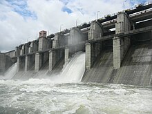 | |
 Location of Majalgaon Dam in Maharashtra | |
| Official name | Jayakwadi Stage-II Dam |
| Location | Majalgaon |
| Coordinates | 19°09′02″N 76°10′54″E / 19.150458°N 76.1816186°E |
| Opening date | 1987 |
| Construction cost | Rs 54,300 Lakhs |
| Owner(s) | Government of Maharashtra, India |
| Dam and spillways | |
| Type of dam | Earthfill |
| Impounds | Sindphana River |
| Height | 31.19 m (102.3 ft) |
| Length | 6,488 m (21,286 ft) |
| Dam volume | 5.759 million cubic meters |
| Spillway type | Gated Ogee |
| Spillway capacity | 14,500 Cumecs |
| Reservoir | |
| Creates | Majalgaon |
| Total capacity | 0.311300 km3 (0.074685 cu mi) |
| Catchment area | 3,840 sq.km |
| Surface area | 78.130 km2 (30.166 sq mi) |
| Power Station | |
| Turbines | 3 |
| Installed capacity | 750 KW each 2250 KW total (max) |
History edit
Majalgaon dam and Majalgaon Right Bank Canal are components of the Jaikwadi Project Stage II. A dam has been constructed across the Sindhaphana river, which is a major tributary of the Godawari river, also known as Dakshin Ganga. The project was approved by the government of Maharashtra in 1976 for an estimated cost of Rs 5433 lakhs.
Majalgon Dam is to be built from earth berms on either side of a gated concrete spillway. The spillway will be approximately 2 kilometers upstream from the town of Majalgaon. The dam will have three hydroelectric generators, each capable of generating 750 kilowatts. In addition, a canal 165 kilometers long was constructed to irrigate 93885 hectares (ICA) of land in Beed, Parbhani & Nanded districts.
Land acquisition and Rehabilitation edit
34 Villages were affected by construction of the dam. Out of these 34, 18 are submerged and two are partly under water. The total area of land covered by water is 7813 ha. No forest land was flooded, and affected villages are relocated in 26 new gawthans.
The height of the dam from its foundation is 31.19 m (102.3 ft) while the length is 6,488 m (21,286 ft). The volume content of dam is 5.759 million cubic meters and gross water storage capacity behind the dam is 0.453640 km3 (0.108834 cu mi).[2]
Purpose edit
Specifications edit
- River : Sindhfana river, Kundlika river, feeding from Nathsagar through P.R.B. Canal
- Location of Dam: 2 km upstream of Majalgaon
- Taluka : Majalgaon
- District: Beed
Yield and Utilization edit
- catchment area : 3840 km2
- average annual yield : 3888.42 m.cum
- 75% dependable yield:2833.83 m.cum
- gross average annual Utilization : 1185.75 m.cum
- % of annual utilization : 72.8%
Dam and reservoir edit
- gross storage: 453.64 m.cum
- dead storage: 142.30 m.cum
- live storage: 311.34 m.cum
- minimum draw down level (MDDL) : 426.11 m. for irrigation 428.35 m. for hydro
- M.W.L: 434.8 m
- F.R.L: 431.8 m
- T.B.L : 435.6 m
- River Bed : 405.4 m
- Crest (क्रेस्ट) Level : 423.8 m
- Canal Sill Level : 424.7 m
Outlet details edit
- Irrigation outlet: 4950 m on right flank
- Power outlet: 4975.25 m on right flank
type Conduct Conduct F.S Discharge 83.8 Cumecs 20 Cumeecs
- M.R.B.C
- Full supply 83.6 Cumecs
- discharge at head
- Length 165 km
- type Lined
- Command Area
- Grass Command area 131520 ha
- Cultivable Command Area 119400 ha
- Net irrigation Area 93885 ha
- Annual Cropped Area 96225 ha
Crops in irrigation area edit
- Sugar cane 3%
- Other perennials 1.5%
- Rice 10%
- L.S.Cotton 25%
- Two Seasonal 3%
- Rabi Seasonal Jawar 15%
- Wheat 25%
- Hot weather 3%
- Kharif Jawar 12%
- gram 5%
District wise Benefited area (I.C.A. in ha)
- Beed 28300
- Parbhani 58385
- Nanded 7200
- Total 93885
Power generation edit
- F.R.L:431.80 m
- M.W.L. (PRESENT): 434.80 m
- T.B.L. :435.60 m
- area of submergence: 7813 ha.
- no. of villages affected due to submergence: 20
Dimensions edit
Height
- above river bed: 31.0 m
- above the foundation: 35.60 m
- RIVER BED : 405.4 m
- Canal sill level : 424.70 m
- Crest level :423.80 m
- free board (present): 00.80 m
QUANTITY:
- earthwork: 5600 T.cum
- masonry: 116 T.cum
- concrete : 43 T.cum
- total length :6488 m
- earth dam : 6143.5 m
- masonry dam : 344.5 m
Spillway edit
- type : gated ogee spillway
- inflow: 19718 cumecs
- outflow: 14500 cumecs
- length of spillway : 239 m
- size of gate : 15x 8 m
- no.of gates : 16
See also edit
References edit
- ^ "Majalgaon D02996". Retrieved 1 March 2013.
- ^ Specifications of large dams in India Archived 21 July 2011 at the Wayback Machine