(Learn how and when to remove this template message)
Majayjay (Tagalog:[mɐhaɪ̯ˈhaɪ̯]), officially designated as the Municipality of Majayjay (Tagalog: Bayan ng Majayjay), is a 4th-class municipality in the province of Laguna, Philippines. As of the 2020 census, the city has a population of 27,893 residents.[3]
Clockwise from the top: Taytay Falls, Saint Gregory the Great Parish Church, Town Proper, Ancestral House, Chapel of Nuestra Señora de la Portería (Ermita).
Geographically, Majayjay is situated at the base of Mount Banahaw; approximately 1,000 feet (300 meters) above sea level. It lies 120 kilometers (75 miles) south of Manila and Manila, shares borders with Magdalena on the north-west, Lucban in Quezon province to the southeast, by Luisiana to the north-east, and Liliw to the west.
Etymologyedit
The original name of Majayjay was Malay Barangay, but many residents assume that Spaniards found it difficult to pronounce, which may have led to early colonizers shortening it to Malay-ay until it became Majayjay.[citation needed] Legends, however, say that it was the difficult journey to Majayjay which gave the town its name; tired travelers supposedly sighed, “Hay!” after scaling a cliff, “Hay!” after ascending a hill, and “Hay!” after crossing a raging river.[5] Thus, guests referred to the place as “Mahayhay,” meaning many sighs, and the Spaniards then spelled this “Majayjay.”
Historyedit
The old Puente de Capricho, an unfinished bridge built in the 1850s
In 1571, The Spanish colonial government made Majayjay into a town,[6] which at the time was one of the most populated settlements in the newly founded province. It competed with Bay and Pagsanjan during the selection of the province's capital.
The popularity of the new town grew during the Spanish period, in part due to its location at the foot of the mountain, which gave it an abundant supply of fresh mountain spring water. Four rivers flowed through the town: Initian, Oobi, Olla, and Balanac (from the falls of Botocan) where all the rivers meet.[citation needed]
Botocan Falls and the town's scenery were uniquely famous, which led to many Europeans and wealthy natives from Manila frequently visiting the town. However, the road to Malay Barangay was considered to be tough.[citation needed] Guests have to be ferried from Manila through the Pasig River to Laguna de Bay. Land travel is done by mounting on horses through a path in the forest and then being be borne by natives in hammocks on the way up to Malay Barangay.[citation needed]
Immediately after the conversion of the natives of Malay Barangay, a makeshift church was built near the May-it River,[citation needed] but it was destroyed by a fire in 1578.[citation needed] Believers built a new church made of bamboo and cogon thatch; however, another fire destroyed it again. A stone church was then built, which was also burned down.[citation needed] In spite of the repeated incidents of fire, the image of their patron saint, San Gregorio Papa Magno survived.[citation needed]
Through the efforts of Padre José de Puertollano, contributions enforced by parishioners, and forced labor of natives, a new church was built in 1730[citation needed], its construction taking nineteen years.[citation needed]
Geographyedit
Majayjay is a geographically landlocked area situated in the southernmost part of the province of Laguna. It nestles at the foot of Mt. Banahaw, and due to its higher altitude at some 2,700+ ft above sea level, the town makes for a popular vacation destination during summer in the Philippines. It was once branded as the 'Summer Capital of the Philippines' 300–400 years ago during the Spanish era, when most of the prominent names in the Spanish colonial Philippines visited the area. Other sights along the streets include the remnants of the said era of Spanish-inspired houses that still stand at periodic key locations, mostly in the town square. Affluent families still have their ancestral houses maintained.[citation needed]
Climateedit
Majayjay is classified as Am in the Köppen–Geiger climate classification, which refers to a tropical monsoon climate. There is significant rainfall in most months of the year, with the annual rainfall averaging 2,571 mm, and the precipitation between the driest month and the wettest month differing by 332 mm. The short dry season has little effect on the overall climate. The temperature here averages 25.8 °C, and during the year, the average temperatures vary by 3.2 °C. The warmest month of the year is May, with an average temperature of 27.4 °C. January has the lowest average temperature of the year, which is 24.2 °C.
Majayjay is politically subdivided into 40 barangays,[8] which is the smallest administrative division in the Philippines. Each barangay consists of puroks, or unofficial divisions within a barangay, and some barangays also have sitios, which are also another unofficial division in a barangay.
Poblacion with town hall on right, public market on left, and St. Gregory church in the background.
In the 2020 census, the population of Majayjay was 27,893 people,[3] with a density of 400 inhabitants per square kilometer or 1,000 inhabitants per square mile.
Majayjay is home to one of the oldest Roman Catholic churches in the Philippines, the Saint Gregory the Great Parish Church. It was built in 1575 through forced labour by the town folks. Inside the church are antique statues of saints brought by the Spaniards in the early era of propagating Christianity. It is somehow true to every church built in the country experienced arson (1576, 1606, and 1660) but later underwent reconstructions and rehabilitation works. Atop the roof of the church is seen the scenic view of Laguna de Bay.
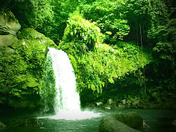
Taytay Falls2. Taytay Falls
Majayjay is also home to the Taytay Falls. Others call it the Majayjay Falls or even Imelda Falls because ex-First Lady Imelda Marcos financed the promotion of tourism in this place. It is a two-story high fall located in remote scenery where forestry is abundant. To reach Taytay Falls, one has to go down the stone steps leading to a kilometre-long trail, constructed in 2008. Recently, the World Bank has sponsored the promotion of tourism in Taytay Falls.
3. Dalitiwan Resort
Dalitiwan Resort is well known for being a running water-typed resort showcasing icy cold water flowing from Mount Banahaw Springs. It is located in barangay Ilayang Banga. To get there, you'll have to ride a jeep or a trike for three minutes or so from the town proper going far down the area before ascending to the zigzag road.
4. Costales Nature Farm
Costales Nature Farm is well known for its unique way of cultivating agricultural and farm products. Organic farming which was first introduced in Majayjay, became a boom and a success. Many people who are after doing the same technique usually visit the farm located in Barangay Gagalot.
5. Coconut Arrack
Commonly called Lambanog. This lambanog is a liquor produced from the extracted Tuba, a sap that is gotten from the coconut tree. However, as you pass along the National Highways, you can probably see Mangangarit skillfully climbing the tree and gliding all the way from one tree to another with the use of two bamboo logs horizontally knotted. There are several stores selling this type of wine, for you to experience its taste just visit the town.
6. Puente de Capriccio
In Rizal's El Filibusterismo, he spoke of an old Spanish bridge made of stone in the year 1851. It was a one-arch bridge since it was not finished, early natives put a bamboo footbridge to connect the opposite sides to make it accessible. Puente de Capriccio was initiated by Spanish Franciscan priest Victoriano del Moral. But the priest was cruel and autocratic, anyone who did not labour in the construction would be later punished by whipping the buttocks. The workers were reportedly not paid a single centavo. Because of his cruelty, the workers campaigned against him, thus, the bridge's construction never resumed since 1851. The bridge is still standing firm today crossing the Olla River. It is called Tulay ng Pige (Bridge of Buttocks) by modern Majayjayenos. The bridge now symbolizes the defiance of Filipino workers against the oppressive Spanish colonialists during the colonial period.
Majayjay is located at the foot of this majestic mountain. In the early Spanish era, Mount Banahaw was called Monte de Majayjay, because it was the town the only way to travel to the mountain. Many European elites visited the town because of its fresh air and the scenic view of Mount Banahaw.
8. Carayan Resort
A resort right at the heart of Majayjay, Laguna, foothills near Mt. Banahaw situated in Barangay Panglan, Majayjay, Laguna - Philippines.
9. Scenic View Resort and Restaurant
Located in Brgy. Ilayang Banga.
10. APA Farms
11. Hillarion's Heritage Farm
12. Bukal Falls
Popular to most tourists as the Enchanted Falls
13. Botocan Hydroelectric Power Plant and Dam
It is the first hydroelectric power plant ever constructed in the Philippines in the 20th century (1930). It is now owned by the CBK Power Company Limited.
14. Ermita Church
Then, a tribunal. This holy place houses the image of Nuestra Señora de la Portería.
15. Our Lady of the Gate Grotto
Situated along the Olla riverbank is a sacred place where masses at times are being held. It is a small tourist destination for religious excursionists.
Cultureedit
Festivalsedit
Majayjay Day is celebrated every year on October 2 as part of the celebration of the founding anniversary of the town. It brags off-farm and agricultural products produced primarily from the 40 barangays composing it. This day has been given a new life and breathing in its new brand name AniLinang Festival. The 1st AniLinang Festival was held on October 2, 2016, as an initiative of the local government to promote the town's laid-back, and peaceful way of life seen in its agricultural produce as well as in its indigenous cuisines.
SaGreMa Festival (San Gregorio Magno Majayjay), is a parochial festivity celebrated on September 3 and March 12, the dates when Saint Gregory, the town's patron saint became a pope and the day he died, respectively. In this time of the year, the Majayjayenos honor the saint for the bountiful year it has been for the town.
Transportationedit
Visiting the town is very accessible and convenient at all four (4) of its entry points: Magdalena-Majayajay Road to the north, Liliw-Majayjay Road to the west, Luisiana-Majayjay Road to the east, and Lucban-Majayjay Road to the south. Public utility vehicles are dispersed such as the local jeepneys and tricycles based in the town centre.
Infrastructureedit
Communicationedit
The town of Majayjay possesses different communication lines including PLDT, and cellular communications such as Globe, Smart, and DITO. Any traveller would find this place very convenient for accessing the online, digital world during their vacation trip.
Educationedit
Secondary schools:
Liceo de Majayjay (High School)
Sta Catalina National High School (Barangay San Miguel, Main Campus and Barangay Bakia, ext.)
Suba National High School (Barangay San Isidro, Main Campus and Barangay Gagalot, ext.)
Elementary schools:
Liceo de Majayjay (Elementary)
Majayjay Elementary School
Sta Catalina Elementary School
Bakia-Botocan Elementary School
Paaralang Elementarya ng Gagalot - Taytay
Suba Elementary School
Bucal Elementary School
Munting Kawayan Elementary School
Governmentedit
Majayjay Municipal Hall
Elected officialsedit
The current municipal council of Majayjay (2022-2025)
^"2015 Census of Population, Report No. 3 – Population, Land Area, and Population Density" (PDF). Philippine Statistics Authority. Quezon City, Philippines. August 2016. ISSN 0117-1453. Archived (PDF) from the original on May 25, 2021. Retrieved July 16, 2021.
^ abcCensus of Population (2020). "Region IV-A (Calabarzon)". Total Population by Province, City, Municipality and Barangay. Philippine Statistics Authority. Retrieved 8 July 2021.
^"PSA Releases the 2018 Municipal and City Level Poverty Estimates". Philippine Statistics Authority. 15 December 2021. Retrieved 22 January 2022.
^Ahlborn, Richard (1960). "The Spanish Churches of Central Luzon (I)". Philippine Studies. 8 (4): 802–813. ISSN 0031-7837.
^
"Majayjay: Average Temperatures and Rainfall". Meteoblue. Retrieved 11 May 2020.
^"Philippine Standard Geographic Code (PSGC) | Philippine Statistics Authority".
^"Official COMELEC Website :: Commission on Elections".
^Census of Population (2015). "Region IV-A (Calabarzon)". Total Population by Province, City, Municipality and Barangay. Philippine Statistics Authority. Retrieved 20 June 2016.
^Census of Population and Housing (2010). "Region IV-A (Calabarzon)" (PDF). Total Population by Province, City, Municipality and Barangay. National Statistics Office. Retrieved 29 June 2016.
^Censuses of Population (1903–2007). "Region IV-A (Calabarzon)". Table 1. Population Enumerated in Various Censuses by Province/Highly Urbanized City: 1903 to 2007. National Statistics Office.{{cite encyclopedia}}: CS1 maint: numeric names: authors list (link)