


Summary
Malekan County (Persian: شهرستان ملکان) is in East Azerbaijan province, Iran. Its capital is the city of Malekan.[2]
Malekan County
Persian: شهرستان ملکان | |
|---|---|
County | |
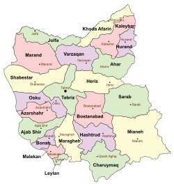 Location of Malekan County in East Azerbaijan province (bottom left, pink) | |
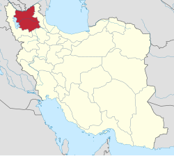 Location of East Azerbaijan province in Iran | |
| Coordinates: 37°06′N 46°12′E / 37.100°N 46.200°E[1] | |
| Country | |
| Province | East Azerbaijan |
| Capital | Malekan |
| Districts | Central, Leylan |
| Population (2016) | |
| • Total | 111,319 |
| Time zone | UTC+3:30 (IRST) |
| Malekan County can be found at GEOnet Names Server, at this link, by opening the Advanced Search box, entering "9205879" in the "Unique Feature Id" form, and clicking on "Search Database". | |
At the 2006 census, the county's population was 100,366 in 24,823 households.[3] The following census in 2011 counted 106,118 people in 29,686 households.[4] At the 2016 census, the county's population was 111,319 in 33,598 households.[5] The county is one of the most productive regions for grapes in Iran.
Etymology edit
The word Malekan is derived from Malek Kandi, "the village of the king." However, there are various theories pertaining to the origin of the name "Malekan Kandi." The first theory is that because the grounds are owned by "GAJAR" government, the city has been named after the founder and the king of the government. The second theory holds that because there have been several kings that have come and gone in the past, it has been named this way. The third and the last theory is that the name Malek Kandi is derived from the name of a king named Maleknia.[citation needed]
Administrative divisions edit
The population history and structural changes of Malekan County's administrative divisions over three consecutive censuses are shown in the following table. The latest census shows two districts, five rural districts, and three cities.[5]
| Administrative Divisions | 2006[3] | 2011[4] | 2016[5] |
|---|---|---|---|
| Central District | 77,132 | 81,949 | 85,938 |
| Gavdul-e Gharbi RD | 19,256 | 20,762 | 17,573 |
| Gavdul-e Markazi RD | 26,623 | 28,383 | 29,010 |
| Gavdul-e Sharqi RD | 7,264 | 7,492 | 7,468 |
| Malekan (city) | 23,989 | 25,312 | 27,431 |
| Mobarak Shahr (city)1 | 4,456 | ||
| Leylan District | 23,234 | 24,169 | 25,381 |
| Leylan-e Jonubi RD | 13,317 | 13,656 | 14,853 |
| Leylan-e Shomali RD | 3,838 | 4,338 | 4,172 |
| Leylan (city) | 6,079 | 6,175 | 6,356 |
| Total | 100,366 | 106,118 | 111,319 |
| RD: Rural District 1Formerly the village of Mobarakabad[6] | |||
References edit
- ^ OpenStreetMap contributors (4 April 2023). "Malekan County" (Map). OpenStreetMap. Retrieved 4 April 2023.
- ^ Habibi, Hassan (22 July 1374). "Divisional reforms in East Azerbaijan province". Qavanin (in Persian). Ministry of Interior, Political and Defense Commission. Archived from the original on 1 January 2022. Retrieved 5 December 2023.
- ^ a b "Census of the Islamic Republic of Iran, 1385 (2006)". AMAR (in Persian). The Statistical Center of Iran. p. 03. Archived from the original (Excel) on 20 September 2011. Retrieved 25 September 2022.
- ^ a b "Census of the Islamic Republic of Iran, 1390 (2011)". Syracuse University (in Persian). The Statistical Center of Iran. p. 03. Archived from the original (Excel) on 16 January 2023. Retrieved 19 December 2022.
- ^ a b c "Census of the Islamic Republic of Iran, 1395 (2016)". AMAR (in Persian). The Statistical Center of Iran. p. 03. Archived from the original (Excel) on 13 November 2020. Retrieved 19 December 2022.
- ^ Jahangiri, Ishaq. "Approval letter regarding reforms of country divisions in East Azerbaijan province". Research Center of the System of Laws of the Islamic Council of the Farabi Library of Mobile Users (in Persian). Ministry of Interior, Council of Ministers. Archived from the original on 6 March 2014. Retrieved 21 February 2024.