
KNOWPIA
WELCOME TO KNOWPIA

Manirang 
Summary
Manirang is one of the highest mountains in the Indian state Himachal Pradesh. It lies on the border between Kinnaur district and Lahaul and Spiti district. Close to the peak is the high Manirang pass, which was one of the early trade routes between Spiti and Kinnaur, before the motorable road was built. The trail over the pass starts from Mane Yogma on the Spiti side and runs to the Ropa valley in Kinnaur.[3]
| Manirang | |
|---|---|
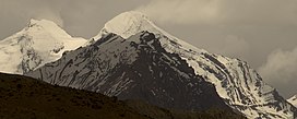 Manirang peak from NW direction | |
| Highest point | |
| Elevation | 6,593 m (21,631 ft)[1] |
| Prominence | 1,727 m (5,666 ft)[1] |
| Listing | Ultra |
| Coordinates | 31°57′12″N 78°22′00″E / 31.95333°N 78.36667°E[1] |
| Geography | |
 Manirang Location in Himachal Pradesh  Manirang Manirang (India) | |
| Location | Himachal Pradesh, India |
| Parent range | Himalaya |
| Climbing | |
| First ascent | 1952, Dr. J. de V. Graaff[2] |
See also edit
References edit
Wikimedia Commons has media related to Manirang.
- ^ a b c "High Asia I: The Karakoram, Pakistan Himalaya and India Himalaya (north of Nepal)". Peaklist.org. Retrieved 28 May 2014.
- ^ Harish Kapadia, High Himalaya Unknown Valleys, fourth edition (Indus Publishing Company, New Delhi, 2001) ISBN 81-7387-117-5
- ^ Kapadia, H. (1999). Spiti: Adventures in the Trans-Himalaya (2nd ed.). New Delhi: Indus Publishing Company. ISBN 81-7387-093-4.