
KNOWPIA
WELCOME TO KNOWPIA

Manneville-la-Goupil 
Summary
Manneville-la-Goupil is a commune in the Seine-Maritime department in the Normandy region in northern France.
Manneville-la-Goupil | |
|---|---|
 The church in Manneville-la-Goupil | |
 Coat of arms | |
Location of Manneville-la-Goupil .mw-parser-output .locmap .od{position:absolute}.mw-parser-output .locmap .id{position:absolute;line-height:0}.mw-parser-output .locmap .l0{font-size:0;position:absolute}.mw-parser-output .locmap .pv{line-height:110%;position:absolute;text-align:center}.mw-parser-output .locmap .pl{line-height:110%;position:absolute;top:-0.75em;text-align:right}.mw-parser-output .locmap .pr{line-height:110%;position:absolute;top:-0.75em;text-align:left}.mw-parser-output .locmap .pv>div{display:inline;padding:1px}.mw-parser-output .locmap .pl>div{display:inline;padding:1px;float:right}.mw-parser-output .locmap .pr>div{display:inline;padding:1px;float:left}html.skin-theme-clientpref-night .mw-parser-output .od,html.skin-theme-clientpref-night .mw-parser-output .od .pv>div,html.skin-theme-clientpref-night .mw-parser-output .od .pl>div,html.skin-theme-clientpref-night .mw-parser-output .od .pr>div{background:#000;color:#fff}html.skin-theme-clientpref-night .mw-parser-output .locmap{filter:grayscale(0.6)}@media(prefers-color-scheme:dark){html.skin-theme-clientpref-os .mw-parser-output .locmap{filter:grayscale(0.6)}html.skin-theme-clientpref-os .mw-parser-output .od,html.skin-theme-clientpref-os .mw-parser-output .od .pv>div,html.skin-theme-clientpref-os .mw-parser-output .od .pl>div,html.skin-theme-clientpref-os .mw-parser-output .od .pr>div{background:#000;color:#fff}}  Manneville-la-Goupil  Manneville-la-Goupil | |
| Coordinates: 49°36′40″N 0°21′14″E / 49.6111°N 0.3539°E | |
| Country | France |
| Region | Normandy |
| Department | Seine-Maritime |
| Arrondissement | Le Havre |
| Canton | Saint-Romain-de-Colbosc |
| Intercommunality | CC Campagne de Caux |
| Government | |
| • Mayor (2020–2026) | Christian Solinas[1] |
| Area 1 | 8.75 km2 (3.38 sq mi) |
| Population (2021)[2] | 1,052 |
| • Density | 120/km2 (310/sq mi) |
| Time zone | UTC+01:00 (CET) |
| • Summer (DST) | UTC+02:00 (CEST) |
| INSEE/Postal code | 76408 /76110 |
| Elevation | 103–136 m (338–446 ft) (avg. 140 m or 460 ft) |
| 1 French Land Register data, which excludes lakes, ponds, glaciers > 1 km2 (0.386 sq mi or 247 acres) and river estuaries. | |
Geography edit
A farming village in the Pays de Caux situated some 12 miles (19 km) northeast of Le Havre, at the junction of the D10 and D52 roads.
Heraldry edit
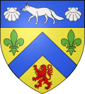 |
The arms of Manneville-la-Goupil are blazoned : Or, a chevron azure between 2 fleurs-de-lys vert and a lion gules, on a chief azure a fox between 2 escallops argent.
|
Population edit
| Year | Pop. | ±% p.a. |
|---|---|---|
| 1968 | 596 | — |
| 1975 | 583 | −0.31% |
| 1982 | 567 | −0.40% |
| 1990 | 809 | +4.54% |
| 1999 | 932 | +1.59% |
| 2007 | 981 | +0.64% |
| 2012 | 1,021 | +0.80% |
| 2017 | 1,021 | +0.00% |
| Source: INSEE[3] | ||
Places of interest edit
- The church of Notre-Dame, dating from the eighteenth century.
- The château de Bourdemare.
See also edit
References edit
- ^ "Répertoire national des élus: les maires". data.gouv.fr, Plateforme ouverte des données publiques françaises (in French). 2 December 2020.
- ^ "Populations légales 2021". The National Institute of Statistics and Economic Studies. 28 December 2023.
- ^ Population en historique depuis 1968, INSEE
Wikimedia Commons has media related to Manneville-la-Goupil.